WKN Weer, Klimaat en Natuurrampen
Lees alles over het onstuimige weer op onze planeet, volg orkanen en tornado's, zie hoe vulkanen uitbarsten en hoe Moeder Aarde beeft bij een aardbeving. Alles over de verwoestende kracht van onze planeet en tal van andere natuurverschijnselen.


Ik dacht dat hij bedoelde "Near PR sat" dat die nu bij Puerto Rico zat, maar daar zie ik niets, afgezien van dat 60% gebied wat de oceaan op trekt en niet richting FL/Golfquote:Op woensdag 20 juli 2011 16:56 schreef aloa het volgende:
[..]
ik denk dat hij voor volgende week bedoelt. Dan lijkt daar inderdaad iets te ontstaan.
ecmwf laat daar volgende week een lage druk zien op de kaarten. Gfs trouwens niet.quote:Op woensdag 20 juli 2011 16:59 schreef Frutsel het volgende:
[..]
Ik dacht dat hij bedoelde "Near PR sat" dat die nu bij Puerto Rico zat, maar daar zie ik niets, afgezien van dat 60% gebied wat de oceaan op trekt en niet richting FL/Golf
Nu zie ik daar ook nietd bijzonders.

http://www.wunderground.c(...)t.html?entrynum=1851quote:An African wave worth watching
An African wave near 45W, midway between the coast of Africa and the Lesser Antilles Islands, is currently generating a limited amount of heavy thunderstorms due to the presence of a large amount of dust and dry air from the Sahara. However, this wave has a modest degree of spin to it, and it is possible it could develop once it finds a moister environment near the Bahama Islands early next week. The last few runs of the UKMET model have shown development of this wave by Tuesday over the Bahamas. The ECMWF and NOGAPS models show that this wave will become a strong tropical disturbance by Tuesday over the Bahamas, while the GFS model shows no development. If this wave does develop, it may recurve before hitting the U.S., since the models agree that there will be a large trough of low pressure present over the U.S. East Coast early next week.


Nieuwe invest in de west pacific. GFS laat deze op de lange termijn tussen Taiwan en de Filipijnen zien. Ook ECMWF laat op de lange termijn een systeem in de buurt van de Filipijnen verschijnen.

op 1 mile na...quote:
Nu 929 en 135kts...
Op het randje van een cat.5

quote:Hurricane Dora in the Eastern Pacific close to Category 5
Hurricane Dora in the Eastern Pacific put on an impressive burst of intensification over the past 24 hours, and is now a very impressive Category 4 storm with 155 mph winds, just 1 mph short of Category 5 status. Dora is expected to move parallel to the coast of Mexico, and should not cause any major trouble in that country. Dora is the second major hurricane in the East Pacific this year; Hurricane Adrian topped out as a Category 4 storm with 140 mph winds in early June.
[ Bericht 5% gewijzigd door #ANONIEM op 21-07-2011 19:03:13 ]
20% inmiddels voor dat gebied. Althans, ik denk dat het die is. Zal dit dan de eerste echte orkaan worden of gaat die ook afbuigen. Krijgen we dit jaar weer zon jaar dat alles afbuigt, net als 2010quote:
[..]
ik denk dat hij voor volgende week bedoelt. Dan lijkt daar inderdaad iets te ontstaan.
Die hittegolf gaat nu naar de oostkust dus misschien word er een blokkade neergezet om afbuiging naar het oosten tegen te gaanquote:
[..]
20% inmiddels voor dat gebied. Althans, ik denk dat het die is. Zal dit dan de eerste echte orkaan worden of gaat die ook afbuigen. Krijgen we dit jaar weer zon jaar dat alles afbuigt, net als 2010Geen idee wat die hittegolf daar voor invloed op heeft.
En invest 90L is up.
Zou een orkaan kunnen gaan worden een koers richting cuba gaan zetten.
Het eerste echte gevaar van 2011.
Zou een orkaan kunnen gaan worden een koers richting cuba gaan zetten.
Het eerste echte gevaar van 2011.

Arlene heeft ook voor flink wat ellende en doden gezorgd. Was net geen orkaan.quote:
En invest 90L is up.
Zou een orkaan kunnen gaan worden een koers richting cuba gaan zetten.
Het eerste echte gevaar van 2011.
[ afbeelding ]
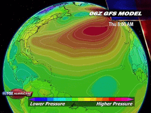
GFS en ECMWF laten nog niets zien. Het NOGAPS model laat begin volgende week wel ontwikkeling zien.
[ Bericht 1% gewijzigd door #ANONIEM op 22-07-2011 19:27:44 ]
Bronquote:Invest 90L: an African wave worth watching
An African wave (Invest 90L) near 14N 55W, 400 miles east of the Lesser Antilles Islands, is moving west-northwest at about 15 - 20 mph. This wave is generating a limited amount of heavy thunderstorms due to the presence of a large amount of dust and dry air from the Sahara, and will spread heavy rain showers and strong gusty winds to the northern Lesser Antilles tonight through Saturday. The wave has a modest degree of spin to it, and is under low wind shear, 5 - 10 knots.
Dry air will continue to be a problem for 90L through Sunday, but once it finds a moister environment near the Bahama Islands early next week, it could develop. However, the expected track of the disturbance takes it over the rugged terrain of Hispaniola, which would inhibit development. Furthermore, wind shear is expected to rise to the moderate range, 10 - 20 knots, on Saturday, and could increase further by Monday, according to most of the computer models. Of the latest 00Z and 06Z runs of the four reliable models for predicting formation of a tropical depression, only the NOGAPS model shows development of 90L. The NOGAPS predicts the wave could attain tropical depression status on Tuesday, over the northwestern Bahama Islands just off the coast of Southeast Florida. The other models generally depict too much wind shear for the wave to develop. Right now, the deck appears stacked against development for 90L through at least Monday. NHC is predicting a 20% chance of development by Sunday. The eventual track of 90L next week has been trending more to the south in recent model runs, as they are generally depicting a weaker trough of low pressure developing over the Eastern U.S. This reduces the chances 90L will move up the U.S. East Coast, and increases the chances that it will enter the Gulf of Mexico.
[ Bericht 1% gewijzigd door #ANONIEM op 22-07-2011 19:27:44 ]
Ben benieuwd of het nog wat gaat worden in de Atlantic. Het ziet er niet heel overtuigend uit nu. Het is niet terug te vinden in de kaarten.
Gebied voor de west pacific ziet er dreigender uit. Dat kan een probleem worden voor de Filipijnen/Taiwan. Halverwege volgende week.
Gebied voor de west pacific ziet er dreigender uit. Dat kan een probleem worden voor de Filipijnen/Taiwan. Halverwege volgende week.


Saffir-Simpson orkaan schaalverdeling wordt aangepast
Het National Hurricane Center (NCH) heeft aangekondigd, dat de schaal betreffende de windsnelheden van orkanen aangepast gaat worden. De verandering in de Saffir-Simpson Hurricane Wind Scale zal minimaal zijn en alleen betrekking hebben op de indeling van de categorie 3, 4 en 5 stormen. De reden waarom de veranderingen worden doorgevoerd is om de conversies tussen knopen, kilometer per uur en mijlen per uur meer accuraat te maken in relatie tot de verschillende orkaan categorieën.
Hoe gaat de Hurricane Wind Speed Scale veranderen?
De grootste verandering vindt plaats in de categorie vier schaal. Momenteel loopt deze van 131 tot 155 mph, 114 tot 135 knopen en 210 tot 249 km/h. Het voorstel van de NHC is om deze te veranderen naar 130 tot 156 mph, 113 tot 136 knopen en 209 tot 251 km/h. Dit impliceert, dat er pas bij een hogere windsnelheid sprake is van een categorie 5 orkaan. De huidige drempel voor een categorie 5 orkaan ligt op 156 mph, 250 km/h en 136 knopen. Na de aanpassing komt de grens te liggen op 157 mph, 252 km/h en 137 knopen. Evenredig gaat ook de bovengrens van de categorie 3 orkanen omlaag; een categorie 3 storm valt binnen de volgende grenzen 111-129 mph, 178-208 km/h en 96-112 knopen.
Alhoewel het geen dramatische veranderingen zijn, maken ze wel een significant verschil bij de conversie tussen de verschillende notatie-eenheden voor windsnelheid en de daarbij behorende waarschuwingen. Hoe zit dit in elkaar?
Het NHC meet de orkaansnelheid in windsnelheid in eenheden van 5 knopen en converteert deze metingen naar mph of km/h wanneer het centrum adviezen cq. waarschuwingen uitgeeft. De meting wordt altijd afgerond naar de dichtstbijzijnde 5 mph of 5 km/h. Dus wanneer een categorie 4 storm maximale windsnelheden heeft van 115 knopen ontstaat er een probleem. De 115 knopen is gelijk aan 132.3 mph. Dit wordt afgerond naar 130 mph, welke onder de categorie 3 intensiteit valt. Met de voorgestelde veranderingen zal het NHC de windsnelheden kunnen converteren voor adviezen en waarschuwingen en blijft daarbij dan in dezelfde categorie. De aanpassing zal geen effect hebben op de historische orkaan gegevens.
Huidige Saffir-Simpson orkaan windsnelheid categorieën
Momenteel zijn er vijf opeenvolgende schalen in de windsterkte. Categorie 1 is de zwakste orkaan en categorie 5 de sterkste, zwaarste orkaan. Iedere storm met windsnelheden minder dan 119 km/h wordt niet geclassificeerd als een orkaan maar als een tropische storm. Het is belangrijk om te onthouden, dat de windsnelheid binnen een orkaan niet evenredig verdeeld is. De hoogste windsnelheden komen vooral voor aan de rechterkant van de orkaan of nabij het oog van de orkaan
* Categorie 1: 74-95 mph; 119-153 km/h; 64-82 knopen
* Categorie 2: 96-110 mph; 154-177 km/h; 83-95 knopen
* Categorie 3: 111-130 (111-129*) mph; 178-209 (178-208*) km/h; 96-113 (96-112*) knopen
* Categorie 4: 131-155 (130-156*) mph; 210-249 (209-251*) km/h; 114-135 (113-136*) knopen
* Categorie 5: Groter of gelijk aan: 156 (157*) mph; 250 (252*) km/h; 136 (137*) knopen
* Voorgestelde windsnelheden
©onweer-online

Negen doden na doortocht tropische storm op Filippijnen
In het oosten van de Filippijnen zijn minstens negen mensen om het leven gekomen door grondverschuivingen en overstromingen veroorzaakt door de tropische storm Nock-Ten.
In de provincie Albay, zo'n 360 kilometer ten zuidoosten van Manilla, vielen zeven slachtoffers. 'Alle dorpen in de provincie staan onder water', aldus provinciaal gouverneur Joey Salceda.
Talloze wegen zijn ontoegankelijk geworden waardoor reddingsteams moeilijk ter plaatse raken. In de naburige provincie Catanduanes kwamen twee mensen om.
Bron
90l staat weer op de kaart. 20% nu.
NHC Invest 90L, Born Again
Invest 90L spiked in thunderstorm activity and circulation yesterday, leading NHC to re-invest the system. 90L is still south of Cuba moving ever-so-slowly to the west. While low level (850mb) circulation has increased since yesterday morning, the system is tilted southeast with height. This is likely due to the westerly wind shear it's facing right now. As the system moves into the Gulf, shear will become more favorable (if there's shear present, easterly is better than westerly). The wave is still moist and moisture is expected to remain high (4 to 5.5 g/kg specific humidity) as it tracks into the Gulf of Mexico.
Again this morning, none of the models are suggesting meaningful development of Invest 90L. However, the GFS (finally) has come around to resolving the circulation at all. Dr. Rob Carver and I spoke this morning, and we came to the conclusion that the lack of observations in this region, combined with the small size of the system, is causing the models to not have the best handle on the situation. The Hurricane Center has a Hurricane Hunter mission scheduled for 18z (2pm EDT) tomorrow, after which we could see the models starting to favor development again. Today the Hurricane Center is forecasting a 20% chance of development over the next 48 hours. I agree with that, but I also think that beyond 48 hours this wave is going to have a better shot at developing a closed circulation at the surface.
NockTen zal voor veel meer doden gaan zorgen wat die is nu ineens enorm aan kracht aan het toenemen.

Het is nu een categorie 1.quote:
NockTen zal voor veel meer doden gaan zorgen wat die is nu ineens enorm aan kracht aan het toenemen.
[ afbeelding ]
Gebied in de Atlantic is nu 70%
[ Bericht 2% gewijzigd door #ANONIEM op 27-07-2011 09:10:16 ]
Als het al wat gaat worden. De kaarten laten nog steeds weinig zien.quote:
70?
die heeft zich ineens ontwikkeld zeg
dat lijkt het eerste serieuze gevaar te worden?
Afwachten maar.
NOCK-TEN trekt na de Filipijnen door richting het zuiden van China en vervolgens is Vietnam weer aan de beurt.
Het dodental op de Filipijnen is opgelopen tot 25. (volgens media op internet).
Het dodental op de Filipijnen is opgelopen tot 25. (volgens media op internet).
![[UGC] Casiguran, Aurora bares the brunt of Juaning](http://i.ytimg.com/vi/YJV6ueZTVEM/default.jpg)
New Tropical Depression Should Form, May Target Texas
"AccuWeather.com meteorologists have pinpointed landfall to occur either late on Friday or Friday night."
A strong tropical wave in the northwestern Caribbean is not only on the verge of organizing into a tropical depression, but may also eventually target Texas.
Interaction with land prevented the tropical wave from wrapping up into an organized tropical system during the past few days.
Now with the wave away from Cuba and over the deep warm water of the northwestern Caribbean, there are signs that an area of low pressure (the next phase of any developing tropical system) is beginning to take shape.
If this trend continues, the birth of the next tropical depression in the Atlantic Basin should occur as early as later today.
The system is forecast to then track through the western Gulf of Mexico tonight into Friday, likely strengthening into Tropical Storm Don in the process.
Without cool water or disruptive wind shear (strong winds high in the atmosphere) ahead of the system to bring about its demise, it is inevitable that the system will make landfall after it enters the western Gulf of Mexico.
AccuWeather.com meteorologists have pinpointed landfall to occur either late on Friday or Friday night. The question is where?
"The key to [the system's] movement will be the strength of the Bermuda high pressure ridge which is nosing westward across Florida into the northern Gulf of Mexico," stated AccuWeather.com Expert Senior Meteorologist John Feerick.
If the ridge maintains its strength, the system will be forced toward South Texas or northern Mexico. The ridge weakening would open the door for the system to target the northwestern Gulf Coast.
Heavy rain and strong, gusty winds would accompany the system wherever it moves inland as a tropical storm (or even a depression).
While flash flooding problems could evolve, the prospect of rain along the western Gulf Coast is definitely news residents want to hear.
Most of coastal Louisiana and Texas are suffering from an extreme to exceptional drought, according to the United States Drought Monitor.
Bron: Accuweather
Tropische storm Nock-ten eist 25 doden in Filipijnen
De tropische storm Nock-ten, die sinds gisteren de Filipijnen teistert, heeft minstens 25 doden gemaakt op Luzon, het grootste eiland van het land. Dat hebben de autoriteiten bericht. Er raakten ook 9 mensen vermist.
Volgens de civiele bescherming zijn de meeste van de 25 dodelijke slachtoffers verdronken of bedolven door aardverschuivingen. (afp/adha)
hln
[ Bericht 0% gewijzigd door #ANONIEM op 27-07-2011 14:26:38 ]

De tropische storm Nock-ten, die sinds gisteren de Filipijnen teistert, heeft minstens 25 doden gemaakt op Luzon, het grootste eiland van het land. Dat hebben de autoriteiten bericht. Er raakten ook 9 mensen vermist.
Volgens de civiele bescherming zijn de meeste van de 25 dodelijke slachtoffers verdronken of bedolven door aardverschuivingen. (afp/adha)


hln
[ Bericht 0% gewijzigd door #ANONIEM op 27-07-2011 14:26:38 ]

Volgens tropical storm risk gaat 'Don' de 50 kts halen. Dat is vergelijkbaar met een windkracht 10 Beaufort. Dus waarschijnlijk gaat het geen orkaan worden.
Maar je weet het maar nooit, soms worden ze ineens sterker dan men verwacht.
Maar je weet het maar nooit, soms worden ze ineens sterker dan men verwacht.
Echt een actief seizoen daar. Zou wat zijn als deze ook al orkaan gaat worden.quote:Op donderdag 28 juli 2011 11:24 schreef aloa het volgende:
20% in de oost pacific. Deze lijkt wel weer een orkaan te gaan worden, volgens GFS.