WKN Weer, Klimaat en Natuurrampen
Lees alles over het onstuimige weer op onze planeet, volg orkanen en tornado's, zie hoe vulkanen uitbarsten en hoe Moeder Aarde beeft bij een aardbeving. Alles over de verwoestende kracht van onze planeet en tal van andere natuurverschijnselen.


Negen doden na doortocht tropische storm op Filippijnen
In het oosten van de Filippijnen zijn minstens negen mensen om het leven gekomen door grondverschuivingen en overstromingen veroorzaakt door de tropische storm Nock-Ten.
In de provincie Albay, zo'n 360 kilometer ten zuidoosten van Manilla, vielen zeven slachtoffers. 'Alle dorpen in de provincie staan onder water', aldus provinciaal gouverneur Joey Salceda.
Talloze wegen zijn ontoegankelijk geworden waardoor reddingsteams moeilijk ter plaatse raken. In de naburige provincie Catanduanes kwamen twee mensen om.
Bron
90l staat weer op de kaart. 20% nu.
NHC Invest 90L, Born Again
Invest 90L spiked in thunderstorm activity and circulation yesterday, leading NHC to re-invest the system. 90L is still south of Cuba moving ever-so-slowly to the west. While low level (850mb) circulation has increased since yesterday morning, the system is tilted southeast with height. This is likely due to the westerly wind shear it's facing right now. As the system moves into the Gulf, shear will become more favorable (if there's shear present, easterly is better than westerly). The wave is still moist and moisture is expected to remain high (4 to 5.5 g/kg specific humidity) as it tracks into the Gulf of Mexico.
Again this morning, none of the models are suggesting meaningful development of Invest 90L. However, the GFS (finally) has come around to resolving the circulation at all. Dr. Rob Carver and I spoke this morning, and we came to the conclusion that the lack of observations in this region, combined with the small size of the system, is causing the models to not have the best handle on the situation. The Hurricane Center has a Hurricane Hunter mission scheduled for 18z (2pm EDT) tomorrow, after which we could see the models starting to favor development again. Today the Hurricane Center is forecasting a 20% chance of development over the next 48 hours. I agree with that, but I also think that beyond 48 hours this wave is going to have a better shot at developing a closed circulation at the surface.

NockTen zal voor veel meer doden gaan zorgen wat die is nu ineens enorm aan kracht aan het toenemen.

Het is nu een categorie 1.quote:Op woensdag 27 juli 2011 02:05 schreef SoldMayor het volgende:
NockTen zal voor veel meer doden gaan zorgen wat die is nu ineens enorm aan kracht aan het toenemen.
[ afbeelding ]
Gebied in de Atlantic is nu 70%
[ Bericht 2% gewijzigd door #ANONIEM op 27-07-2011 09:10:16 ]

Als het al wat gaat worden. De kaarten laten nog steeds weinig zien.quote:
70?
die heeft zich ineens ontwikkeld zeg
dat lijkt het eerste serieuze gevaar te worden?
Afwachten maar.
NOCK-TEN trekt na de Filipijnen door richting het zuiden van China en vervolgens is Vietnam weer aan de beurt.
Het dodental op de Filipijnen is opgelopen tot 25. (volgens media op internet).
Het dodental op de Filipijnen is opgelopen tot 25. (volgens media op internet).
![[UGC] Casiguran, Aurora bares the brunt of Juaning](http://i.ytimg.com/vi/YJV6ueZTVEM/default.jpg)
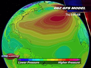
New Tropical Depression Should Form, May Target Texas
"AccuWeather.com meteorologists have pinpointed landfall to occur either late on Friday or Friday night."
A strong tropical wave in the northwestern Caribbean is not only on the verge of organizing into a tropical depression, but may also eventually target Texas.
Interaction with land prevented the tropical wave from wrapping up into an organized tropical system during the past few days.
Now with the wave away from Cuba and over the deep warm water of the northwestern Caribbean, there are signs that an area of low pressure (the next phase of any developing tropical system) is beginning to take shape.
If this trend continues, the birth of the next tropical depression in the Atlantic Basin should occur as early as later today.
The system is forecast to then track through the western Gulf of Mexico tonight into Friday, likely strengthening into Tropical Storm Don in the process.
Without cool water or disruptive wind shear (strong winds high in the atmosphere) ahead of the system to bring about its demise, it is inevitable that the system will make landfall after it enters the western Gulf of Mexico.
AccuWeather.com meteorologists have pinpointed landfall to occur either late on Friday or Friday night. The question is where?
"The key to [the system's] movement will be the strength of the Bermuda high pressure ridge which is nosing westward across Florida into the northern Gulf of Mexico," stated AccuWeather.com Expert Senior Meteorologist John Feerick.
If the ridge maintains its strength, the system will be forced toward South Texas or northern Mexico. The ridge weakening would open the door for the system to target the northwestern Gulf Coast.
Heavy rain and strong, gusty winds would accompany the system wherever it moves inland as a tropical storm (or even a depression).
While flash flooding problems could evolve, the prospect of rain along the western Gulf Coast is definitely news residents want to hear.
Most of coastal Louisiana and Texas are suffering from an extreme to exceptional drought, according to the United States Drought Monitor.
Bron: Accuweather
Tropische storm Nock-ten eist 25 doden in Filipijnen
De tropische storm Nock-ten, die sinds gisteren de Filipijnen teistert, heeft minstens 25 doden gemaakt op Luzon, het grootste eiland van het land. Dat hebben de autoriteiten bericht. Er raakten ook 9 mensen vermist.
Volgens de civiele bescherming zijn de meeste van de 25 dodelijke slachtoffers verdronken of bedolven door aardverschuivingen. (afp/adha)
hln
[ Bericht 0% gewijzigd door #ANONIEM op 27-07-2011 14:26:38 ]

De tropische storm Nock-ten, die sinds gisteren de Filipijnen teistert, heeft minstens 25 doden gemaakt op Luzon, het grootste eiland van het land. Dat hebben de autoriteiten bericht. Er raakten ook 9 mensen vermist.
Volgens de civiele bescherming zijn de meeste van de 25 dodelijke slachtoffers verdronken of bedolven door aardverschuivingen. (afp/adha)


hln
[ Bericht 0% gewijzigd door #ANONIEM op 27-07-2011 14:26:38 ]

Volgens tropical storm risk gaat 'Don' de 50 kts halen. Dat is vergelijkbaar met een windkracht 10 Beaufort. Dus waarschijnlijk gaat het geen orkaan worden.
Maar je weet het maar nooit, soms worden ze ineens sterker dan men verwacht.
Maar je weet het maar nooit, soms worden ze ineens sterker dan men verwacht.
Echt een actief seizoen daar. Zou wat zijn als deze ook al orkaan gaat worden.quote:Op donderdag 28 juli 2011 11:24 schreef aloa het volgende:
20% in de oost pacific. Deze lijkt wel weer een orkaan te gaan worden, volgens GFS.