WKN Weer, Klimaat en Natuurrampen
Lees alles over het onstuimige weer op onze planeet, volg orkanen en tornado's, zie hoe vulkanen uitbarsten en hoe Moeder Aarde beeft bij een aardbeving. Alles over de verwoestende kracht van onze planeet en tal van andere natuurverschijnselen.


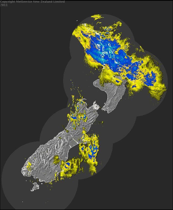
Zodan dat is dan aardig wat, de neerslagkaart hierboven is van de afgelopen 12 uur, mss 200+mm. Moet er niet aan denken, vriendin van mijn broertje gaat vandaag terug naar Auckland, zal een drama zijn daarquote:Op vrijdag 28 januari 2011 12:17 schreef aloa het volgende:
[..]
Ik heb het net gelezen.
Er wordt nog zo'n 80 - 150 mm verwacht.
[..]
Weer of geen weer, altijd actueel www.onweer-online.nl

Het regent hard in het noorden. De wind is afgezwakt naar 80 km/uur met windstoten nog boven de 100 km/uur.quote:Op vrijdag 28 januari 2011 12:25 schreef meteo-online het volgende:
[..]
Zodan dat is dan aardig wat, de neerslagkaart hierboven is van de afgelopen 12 uur, mss 200+mm. Moet er niet aan denken, vriendin van mijn broertje gaat vandaag terug naar Auckland, zal een drama zijn daar
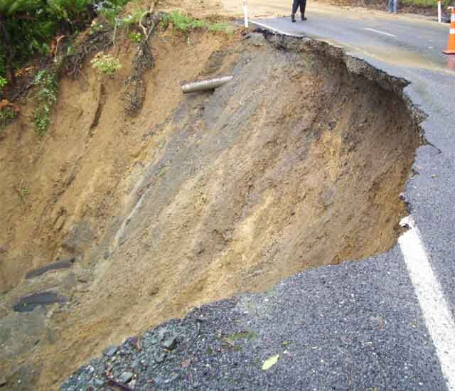
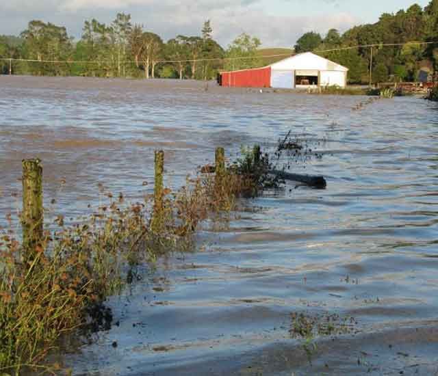
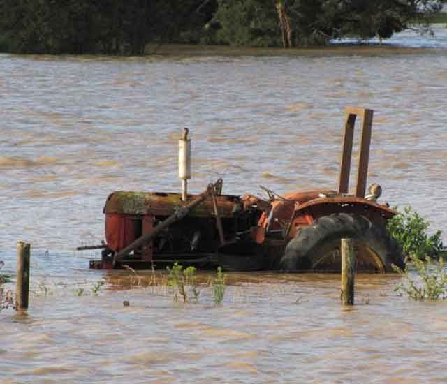
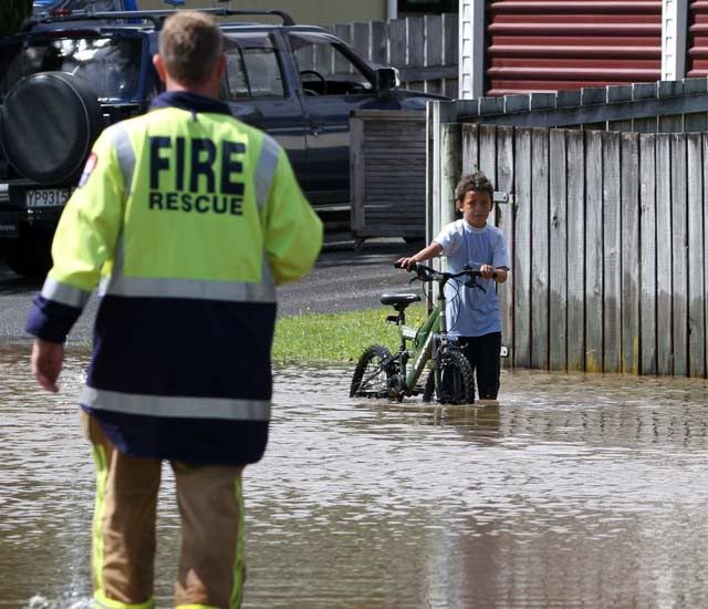
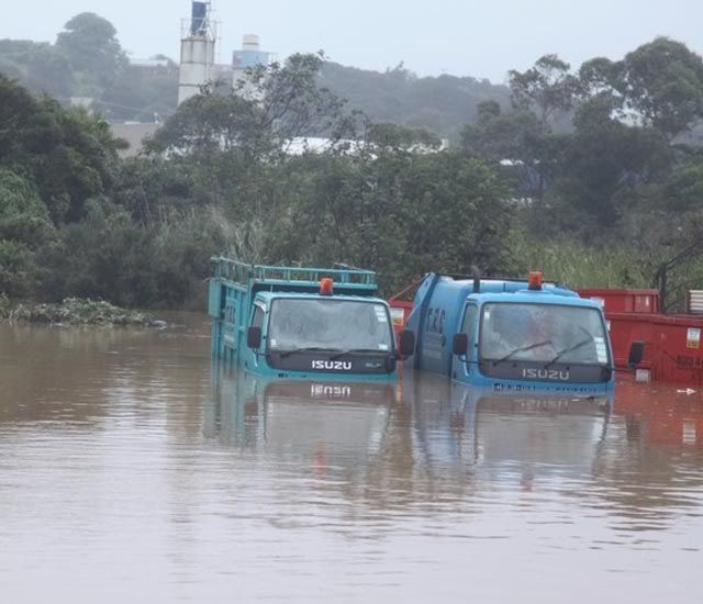
In New Zeeland zijn meldingen van omgevallen bomen en overstromingen waardoor een aantal wegen afgesloten zijn. Er wordt gewaarschuwd om niet de weg op te gaan
[ Bericht 17% gewijzigd door #ANONIEM op 28-01-2011 14:04:06 ]
quote:Cyclone Wilma hits Northland
Flooding has trapped two Kaeo families in their homes and another two people in their car as the remnants of Cyclone Wilma cause havoc across Northland.
Police Inspector Shawn Rutene said slips, flooding and fallen trees had caused a number of road closures.
Emergency services were working to rescue two families were trapped in their homes by the rising Kaeo River, he said.
Elsewhere in Northland, police were trying to rescue two people trapped after logs blocked the road at Okaihau and in the Coromandel two people were trapped in a car.
Emergency services throughout Northland were stretched and police were asking people to keep off the roads, Rutene said.
Police expected when high tide hit around 4am some low lying roads would be impassable due to water.
There was also understood to be flooding in Matakana, Mangawhai and along the waterfront at Paihia.
Earlier, MetService warned that Wilma's remnants would bring heavy rain to Northland, Auckland, Waikato, the Coromandel Peninsula, Bay of Plenty and Gisborne.
Rainfall rates were forecast to reach up to 25 to 40mm per hour for a time.
Strong or gale force winds were also forecast. Winds were forecast to reach severe gale overnight in parts of eastern Northland and Great Barrier Island where gusts of 130 km/h were possible, MetService said.
Northeast swells and very rough seas were forecast for eastern coastal areas from Northland to East Cape.
Rain should clear from most areas by midday tomorrow, though it may continue into the afternoon for Gisborne, MetService said.
[ Bericht 17% gewijzigd door #ANONIEM op 28-01-2011 14:04:06 ]
quote:The Bay of Plenty, Northland and the Coromandel have a clean up job on their hands after tropical cyclone Wilma battered the regions over night.
For the second weekend in a row coastal towns and rivers were flooded, closing roads and causing evacuations.
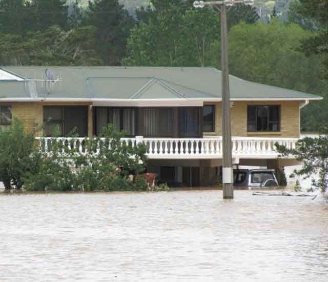
The bucketing rain left roads up north underwater, and homes, as well as water and sewage treatment plants were damaged.
State Highway One heading north from Auckland was closed with traffic having to be diverted.
The New Zealand Transport Authority says people should only drive if absolutely necessary, and if they do they should take extreme care.
The Bay of Plenty also copped it again after being soaked last weekend.
On State Highway 2 between Tauranga and Whakatane there were three slips within two kilometres. Trucks were trapped in between them, drivers couldn't get out but they were lucky just to be able to stop in time.
Campers at the Mt Maunganui campground were woken at 4am by the flooding.
Despite the rain, Tauranga City residents are being urged to conserve water for the next 24 hours.
Both of the city's water processing plants have been shut down because of the heavy rain, and a major water main's broken meaning the city's relying on reservoir storage.
Some campers though have still been able to enjoy themselves.
I thought better transport kayaking down than walking down so I thought I would give it a go, says camper Shaun Middleton.
In Waipuna nine patients were evacuated from a hospice as river water surged from the Kaimai Ranges.
We had volunteers with four wheel drives ferrying people back and forwards across the flood, they became our ferry for the day, says Waipuna Hospice CEO Richard Thurlow.
Further north in the Coromandel it was a similar story.
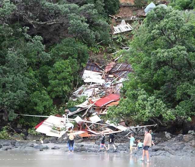
A slip on the Thames Coast road forced the evacuation of two houses, one of which could still come down with the moving earth.
Some of the boulders that have come through are the size of cars. There's a pine tree on the beach that was on the front yard of one of the houses that was evacuated, so it's reasonably dangerous, says Thames volunteer fire brigade station officer Ken Brokenshire.
Tropical cyclone Wilma has now passed over the North Island, however the MetService is warning that gale force winds will hit exposed places in the Far North, Auckland, East Coast and Taranaki.

Neerslagtotalen van de afgelopen 24-uur in Nieuw-Zeeland

Weer of geen weer, altijd actueel www.onweer-online.nl
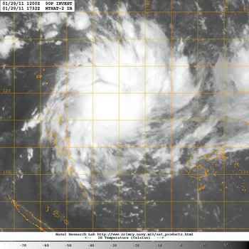
Yasi is zich inmiddels aan het ontwikkelen ter hoogte van de Vanuatu eilanden en zal waarschijlijk donderdag Queensland treffen.
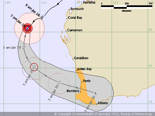
quote:Two cyclones threaten flood-ravaged Qld
Communities along almost 2000 kilometres of Queensland coastline are preparing for the first of two tropical cyclones to hit.
By 7pm (AEST) on Saturday, Tropical Cyclone Anthony was about 830 kilometres northeast of Townsville and was expected to cross the coast late on Sunday or early Monday as a category one or low category two system.
The Bureau of Meteorology (BOM) is expecting high rainfall for north and central Queensland and abnormally high tides are expected between Townsville and Bowen.
It comes amid concern a second cyclone, named Yasi, will develop from an intense tropical low currently near Fiji and hit the Queensland coast next Thursday.
The area of concern extends 1700 kilometres from Cooktown down to Hervey Bay, including several major population centres - Cairns, Townsville, Mackay, Rockhampton, Gladstone and Bundaberg.
State disaster management coordinator Ian Stewart urged people living in these areas to prepare.
"The reason we are considering this broader area, is to ensure that the preparations of the community and emergency service personnel are adequate for Tropical Cyclone Anthony ... and a further cyclone Yasi, later in the week," he said.


quote:Cycloon Anthony nadert Queensland
De cycloon Anthony nadert langzaam richting de kust van Queensland, momenteel gelden er al waarschuwingen voor voor de kustplaatsen van Innisfail tot aan Saint Lawrence. Anthony is al de gehele week Queensland aan het "teisteren", nadat hij zich eerst ontwikkelde voor de noordoost kust in de buurt van Willis Island. Terwijl velen al dachten de cycloon uit beeld was, had Anthony andere plannen en maakte een drastische ommezwaai.
De categorie een cycloon is nog steeds meer dan 900 kilometer ten oost-noordoosten van Townsville en trekt langzaam naar het zuidwesten. Doordat de cycloon eerst nog door de warme wateren van de Coral Sea trekt, kan het zijn dat de cycloon Anthony nog licht gaat intensiveren als hij de kust nadert van Queensland. Tegen het eind van zondag kunnen er zware wind en windstoten zich ontwikkelen aan de kustgebieden en eilanden tussen Innisfail en St Lawrence. De verwachting is dat Anthony in de buurt van Townsville vanaf zondagavond of in de vroege ochtenduren van maandag aan land komt.
Zware regenval wordt er ook verwacht in het noordoosten, voornamelijk in Herbert en Neder-Burdekin districten. Overstromingen zijn niet uitgesloten. Queensland is momenteel nog herstellende van de overstromingen die zich eind vorig jaar en begin dit jaar voordeden.

Weer of geen weer, altijd actueel www.onweer-online.nl
Nieuw noodweer koerst af op Australië
BRISBANE - Het oosten van Australië zet zich schrap voor nieuw noodweer. Twee cyclonen koersen af op de staat Queensland. In de loop van zondag komt de eerste, Anthony genaamd, aan land.
Het Australische weersinstituut BOM waarschuwt voor zware windstoten en extreme regenval.
Tegen het einde van komende week krijgt het oosten van Australië te maken met de tweede cycloon, Yasi. Die hangt nu boven Vanuatu, een eilandengroep in de Grote Oceaan ten oosten van Australië. Yasi lijkt nog zwaarder te worden dan Anthony.
De premier van Queensland, Anna Bligh, noemde de twee cyclonen zondag ''David en Goliath
Binnenlandse tsunami
Queensland werd onlangs getroffen door zware overstromingen na de cycloon Tasha. Een enorm gebied kwam onder water te staan. Ongeveer dertig mensen kwamen om het leven. Sommige dorpen kregen te maken met wat een ''binnenlandse tsunami werd genoemd.
De weersoverlast wordt vermoedelijk veroorzaakt door het klimaatverschijnsel La Niña, een zeestroming die vanuit Zuid-Amerika richting Australië en de Indische Oceaan gaat. Door La Niña, de tegenhanger van het bekendere El Niño, is het zeewater bij Australië al maanden warmer dan gemiddeld.
Daardoor verdampt meer water dan normaal, wat leidt tot zware regenval in kustgebieden.
nu.nl
[ Bericht 0% gewijzigd door #ANONIEM op 30-01-2011 13:25:03 ]
Cycloon Anthony is aan land gekomen tussen de steden Ayr en Mackay. Daarbij zijn windstoten tot 155 km geregistreerd. Naast de wind is ook de neerslag op dit moment een probleem. Er is in het district Clarke Range tot nu toe 171 mm gevallen. In de steden Bowen, Airlie Beach and Sarina zitten 10.000 huishoudens zonder elektriciteit.
Weer of geen weer, altijd actueel www.onweer-online.nl
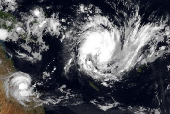
Qua omvang is Yasi echt de Goliath onder de cyclonen.
Anthony en Yasi
Yasi heeft nu een windsnelheid van 80 km/uur en windstoten tot 105 km/uur.
De storm zal verder in kracht toenemen en naar verwachting zal deze zelfs een categorie 3 sterkte bereiken. De cycloon zal in hetzelfde gebied landfall gaan maken als Anthony.
Anthony en Yasi
Yasi heeft nu een windsnelheid van 80 km/uur en windstoten tot 105 km/uur.
De storm zal verder in kracht toenemen en naar verwachting zal deze zelfs een categorie 3 sterkte bereiken. De cycloon zal in hetzelfde gebied landfall gaan maken als Anthony.
Anthony heeft nog windsnelheden behaald tot 150 km/uur. (dichtbij de kern van het systeem).
Het trekt nu weg als tropische depressie met nog steeds veel neerslag, op sommige plaatsen is tegen de 300 mm regen gevallen.
Het trekt nu weg als tropische depressie met nog steeds veel neerslag, op sommige plaatsen is tegen de 300 mm regen gevallen.
quote:Tropical Cyclone Anthony has been downgraded to a tropical low after crossing the Queensland coast but is still causing severe conditions in the state's north.
Tropical Cyclone Anthony crossed the coast near Bowen about 10pm (AEST) as a category two system.
It was packing winds of up to 150 kilometres an hour near its core.
Weather bureau senior forecaster Ben Annells says there has been falls of up to 300 millimetres in the Pioneer River catchment near Mackay.
"That heavier rain is starting to move inland as well and we're starting to see some falls above 50 millimetres through parts of the central interior of Queensland," he said.
Even though the system has since been downgraded to a tropical low, the bureau is still warning of heavy rainfall and damaging wind gusts about the central coast, the Whitsundays, and the northern parts of the Central Highlands and coalfields.
Jammer dat ik geen neerslaggegevens binnen krijg van Australie 
Weer of geen weer, altijd actueel www.onweer-online.nl
Alle ogen gericht op cycloon Yasi
De bewoners van Rockhampton, die afgelopen maand getroffen werden door overstromingen kunnen hun borst nat maken. De bewoners zijn gewaarschuwd om zich voor te bereiden. Yasi zal naar alle waarschijnlijkheid een potentiële gevaarlijke cycloon gaan worden, die woensdagavond of donderdag met een categorie 3 aan land zal komen. Momenteel berekenen de weermodellen van de US Navy dat er windstoten voor kunnen gaan komen die op kunnen lopen tot 200 kilometer per uur.
Verwacht wordt dat cycloon Yasi aan land komt tussen Cooktown en Hervey Bay. De cycloon is minstens vier keer zo groot als cycloon Anthony. Naarmate de dag vordert zal er meer informatie volgen door het meteorologisch bureau (BOM), die hebben de verantwoordelijkheid op dat gebied. De computer modellen suggereren dat het heel snel naar het oosten zal trekken in de komende paar dagen.
Er moet niet alleen gekeken worden naar de wind die de cycloon met zich meebrengt, ook enorme hoeveelheden neerslag worden er verwacht in het centraal Queensland later deze week. De verwachtte neerslag loopt momenteel uiteen van meer dan 200mm voor St Lawrence, 150mm voor Rockhampton en bijna 300mm bij Mackay. Deze enorme hoeveelheden neerslag kunnen makkelijk leiden tot overstromingen.
©onweer-online
[ Bericht 0% gewijzigd door meteo-online op 31-01-2011 09:50:08 ]
De bewoners van Rockhampton, die afgelopen maand getroffen werden door overstromingen kunnen hun borst nat maken. De bewoners zijn gewaarschuwd om zich voor te bereiden. Yasi zal naar alle waarschijnlijkheid een potentiële gevaarlijke cycloon gaan worden, die woensdagavond of donderdag met een categorie 3 aan land zal komen. Momenteel berekenen de weermodellen van de US Navy dat er windstoten voor kunnen gaan komen die op kunnen lopen tot 200 kilometer per uur.

Verwacht wordt dat cycloon Yasi aan land komt tussen Cooktown en Hervey Bay. De cycloon is minstens vier keer zo groot als cycloon Anthony. Naarmate de dag vordert zal er meer informatie volgen door het meteorologisch bureau (BOM), die hebben de verantwoordelijkheid op dat gebied. De computer modellen suggereren dat het heel snel naar het oosten zal trekken in de komende paar dagen.
Er moet niet alleen gekeken worden naar de wind die de cycloon met zich meebrengt, ook enorme hoeveelheden neerslag worden er verwacht in het centraal Queensland later deze week. De verwachtte neerslag loopt momenteel uiteen van meer dan 200mm voor St Lawrence, 150mm voor Rockhampton en bijna 300mm bij Mackay. Deze enorme hoeveelheden neerslag kunnen makkelijk leiden tot overstromingen.
©onweer-online
[ Bericht 0% gewijzigd door meteo-online op 31-01-2011 09:50:08 ]
Weer of geen weer, altijd actueel www.onweer-online.nl

Yasi gaat een categorie 4 worden. Er wordt gewaarschuwd voor een windveld van 260 km/uur.
quote:People in north Queensland have been warned to expect wind speeds of up to 260 kilometres per hour when a "big, ugly sister" cyclone makes landfall later this week.
Emergency Management Queensland (EMQ), police and weather officials are meeting across the state's far north today to discuss the possible threat of Tropical Cyclone Yasi.
The category-one system is north-west of Vanuatu but is expected to intensify before crossing the Queensland coast on Wednesday or Thursday.
Authorities fear the massive cyclone could be as intense as Cyclone Larry, which devastated parts of far north Queensland in 2006.
Queensland Police says it is the "big, ugly sister" to Cyclone Anthony, which caused only minor damage as it crossed the state's north coast near Bowen, south of Townsville, overnight.

Sommige plaatsen meer dan 100mm afgelopen 24 uur.
Anthony heeft goed zijn werk gedaan en er komt een nog veel grotere aan

Doomsdaydonderdag voor Queenslandquote:Thursday's cyclone to be 'a state event'
North Queensland has endured the destructive winds of Cyclone Anthony, but the weather bureau is warning a bigger cyclone that's likely to affect a much larger area of the state is on the way.
Cyclone Yasi is just north of Vanuatu, about 2000 kilometres east-northeast of Bowen, which suffered only minor damage when Anthony crossed the coast on Sunday night.
Unlike Anthony, which weakened into a low pressure system after crossing land, Yasi is expected to menace Queensland as a strong cyclone even after crossing the coast.
Advertisement: Story continues below
Queensland's Bureau of Meteorology says it's likely to cross the north coast either on Wednesday night or Thursday morning.
The bureau's senior forecaster Gordon Banks said Yasi would be big and intense, bringing destructive winds and heavy rain across the state.
He said like January's devastating floods, Yasi will most likely be a state event.
"It's going to affect a much larger area [than Anthony] both with rainfall and wind and because of its size and strength, it's likely to persist as a cyclone even after it crosses land," Mr Banks told ABC Radio.
"I think eventually Yasi will be a whole state event."