WKN Weer, Klimaat en Natuurrampen
Lees alles over het onstuimige weer op onze planeet, volg orkanen en tornado's, zie hoe vulkanen uitbarsten en hoe Moeder Aarde beeft bij een aardbeving. Alles over de verwoestende kracht van onze planeet en tal van andere natuurverschijnselen.


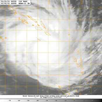
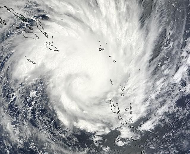
Yasi op weg naar Queensland Australie.
zie ook:
Overstromingen Australie: Ergste in honderd jaar
Hurricane Season 2011
[ Bericht 2% gewijzigd door Frutsel op 31-01-2011 12:26:55 ]


quote:Alle ogen gericht op cycloon Yasi
De bewoners van Rockhampton, die afgelopen maand getroffen werden door overstromingen kunnen hun borst nat maken. De bewoners zijn gewaarschuwd om zich voor te bereiden. Yasi zal naar alle waarschijnlijkheid een potentiële gevaarlijke cycloon gaan worden, die woensdagavond of donderdag met een categorie 3 aan land zal komen. Momenteel berekenen de weermodellen van de US Navy dat er windstoten voor kunnen gaan komen die op kunnen lopen tot 200 kilometer per uur.
Verwacht wordt dat cycloon Yasi aan land komt tussen Cooktown en Hervey Bay. De cycloon is minstens vier keer zo groot als cycloon Anthony. Naarmate de dag vordert zal er meer informatie volgen door het meteorologisch bureau (BOM), die hebben de verantwoordelijkheid op dat gebied. De computer modellen suggereren dat het heel snel naar het oosten zal trekken in de komende paar dagen.
Er moet niet alleen gekeken worden naar de wind die de cycloon met zich meebrengt, ook enorme hoeveelheden neerslag worden er verwacht in het centraal Queensland later deze week. De verwachtte neerslag loopt momenteel uiteen van meer dan 200mm voor St Lawrence, 150mm voor Rockhampton en bijna 300mm bij Mackay. Deze enorme hoeveelheden neerslag kunnen makkelijk leiden tot overstromingen.
©onweer-online
zie ook:
Overstromingen Australie: Ergste in honderd jaar
Hurricane Season 2011
[ Bericht 2% gewijzigd door Frutsel op 31-01-2011 12:26:55 ]
Wat een drama voor die mensen daar. Hebben ze net het ergste achter de rug, en begint het allemaal weer opnieuw. 
Ze hebben vannacht 100mm water gehad in Queensland, door Cycloon Anthonyquote:Op maandag 31 januari 2011 11:14 schreef Infection het volgende:
Wat een drama voor die mensen daar. Hebben ze net het ergste achter de rug, en begint het allemaal weer opnieuw.
Komt dit er nog achteraan

Yasi kan de grootste cycloon worden die Australie ooit heeft gezien. De verwachting is dat de cycloon met windsnelheden tot 260 km landfall gaat maken en een enorme hoeveelheid aan neerslag gaat achterlaten.
[ Bericht 0% gewijzigd door #ANONIEM op 31-01-2011 12:50:05 ]

quote:Premier Anna Bligh says the cyclone bearing down on the Queensland coast has the potential to be the biggest the state has ever seen.
Ms Bligh is calling on Queenslanders to prepare for gale-force winds, torrential rain and massive storm surges when Cyclone Yasi crosses the coast on Wednesday night.
Authorities fear the massive cyclone, which could pack winds up to 260 kilometres per hour, may be as intense as Cyclone Larry, which devastated parts of far north Queensland in 2006.
"[Yasi] may well be one of the largest and most significant cyclones that we have ever had to deal with," Ms Bligh said.
"This is an event we have to take seriously. I know cyclones can at the last minute turn off the coast, and I certainly hope this one does.
"But the bureau advises me in the most serious terms, that all of the modelling right now says this is going to cross our coast."
Ms Bligh says Yasi is expected to turn into a category-four system by Wednesday.
She says while areas between Cooktown and Maryborough are likely to be affected, the Innisfail to Mackay region will bear the brunt of the cyclone.
"We expect to see gales in that Innisfail to Mackay region of more than 100kph by mid-morning on Wednesday," she said.
"We are encouraging people in that region to start stocking up and begin preparing yourselves, your homes and your families for a very significant event."
She says the threat of the cyclone is compounded by severe rainfall in areas already saturated by a wet summer.
"In addition to the effects of a cyclone, we are preparing in that Innisfail to Mackay region for potential flooding of low-lying waterfront areas," she said.
"The best advice we can give to people in those areas is to start considering possible relocation on Tuesday."
Ms Bligh says the rain could affect areas in central and western Queensland still reeling from December's floods.
"We expect to see this event to become a significant rainfall event in areas to the south and surrounding where it crosses the coast.
"That means we can expect very significant rainfall, in some cases up to a metre, into catchments that are already saturated."
"We are currently doing modelling into what that might mean, particularly into areas such as the central and western areas of Queensland... which we have already seen significant flooding in."
All ports from Cairns to Mackay will be closed by tomorrow afternoon and the Premier is urging those with waterfront properties in the affected areas to evacuate.
Evacuations have already started at some nursing homes in the main danger zone and at Hamilton Island in the Whitsundays.
Weather forecasters says it is very unusual to have two cyclones tracking the same path only days apart.
Yasi is tracking a very similar path to Cyclone Anthony that crossed the coast near Bowen on Sunday night.
Forecaster Greg Connors says he cannot remember anything quite like it.
"Usually at this time of year the Coral Sea is constantly changing, but for the next few days it's showing a general westerly flow and that flow is capturing not only Anthony but also the upstream Tropical Cyclone Yasi," he said.
[ Bericht 0% gewijzigd door #ANONIEM op 31-01-2011 12:50:05 ]
Ze vergelijken hem al met de cycloon Larry die in 2006 voor veel ellende heeft gezorgd
Weer of geen weer, altijd actueel www.onweer-online.nl

Wat een joekel joh 
Ik dacht dat ze hem zouden vergelijk die met eind 19e eeuw, Larry of Vance, maar Larry dus.
Arm Queensland 
Ik dacht dat ze hem zouden vergelijk die met eind 19e eeuw, Larry of Vance, maar Larry dus.
Arm Queensland

quote:Yasi could be Qld's worst storm
QUEENSLAND'S island resorts are being evacuated and ports closed ahead of Cyclone Yasi, which threatens to develop into one of the worst storms the state has seen.
Premier Anna Bligh on Monday said Hamilton Island, in the Whitsundays, was starting to evacuate its guests, and other resort islands were preparing to evacuate on Tuesday.
Yasi will be a severe category three or four cyclone when it crosses the coast on Thursday morning, likely between Innisfail and Proserpine.
Ms Bligh told reporters that authorities were preparing for the cyclone to trigger a storm surge that could flood low-lying areas between Innisfail and Mackay.
Residents in low-lying waterfront areas there should consider staying with friends from Tuesday, she said.
"This is a very serious threat," Ms Bligh told reporters in Brisbane.
"We have to take this very seriously and we're preparing for it.
"In addition to a very significant cyclone, possibly one of the largest we have ever seen in Queensland, we expect to see this event become a significant rainfall event in areas to the south and surrounding where it crosses the coast."
Falls of up to one metre could hit areas that have already been flooded this month, and the government was working on models to show what that would mean for central Queensland.
Ports from Cairns to Mackay will be closed from late on Tuesday.
Yasi was not expected to dissipate quickly, or turn off the coast, Ms Bligh said.
"All of the modeling right now says this is going to cross our coast ... and it may well be one of the largest and most significant cyclones that we've ever had to deal with," she said.
"We will need to take every precaution and make every preparation and that is what we are doing."
Yasi could rival Larry: BoM
A SEVERE cyclone expected to hit Queensland on Thursday is likely to rival, and on some measures, dwarf Cyclone Larry, which devastated parts of north Queensland.
The Bureau of Meteorology says Cyclone Yasi will be a severe category three or four cyclone when it crosses the Queensland coast, likely early on Thursday morning.
Bureau senior forecaster Ann Farrell said the latest modelling suggested Yasi would make landfall somewhere between Innisfail, in the north, and Proserpine, in the south.
If it hits as a category three, wind gusts up to 200km/h can be expected, and 250km/h if it builds to a four, as Cyclone Larry was when it devastated Innisfail and surrounding communities in March 2006.
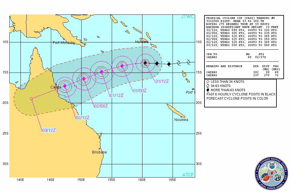
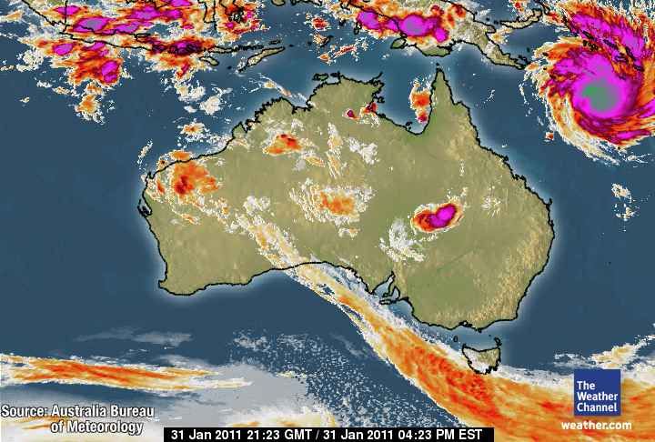
It's currently off Vanuatu, about 1975km east, northeast of Townsville, and moving westward at about 30km/h.
"At this stage we're expecting it to continue moving towards the Queensland coast and intensify ... and it's likely to reach the coast early on Thursday morning," Ms Farrell told AAP on Monday.
"By that stage we will be looking at a severe tropical cyclone so certainly at least a (category) three, and a category four we wouldn't be ruling that out by any means."
She said the last cyclone of that magnitude to hit Queensland was category four Cyclone Larry.
Larry left a trail of destruction including damage to 10,000 homes and a repair bill of more than a billion dollars.
Ms Farrell said there were many measures on which to judge cyclones, including wind strength and the physical size of the storm.
In terms of wind strength, Yasi had the potential to rival Larry, but it was of a far greater physical size.
"One measure is how far do the gales extend from the central eye. In this case, Yasi is certainly a bigger storm," she said.
She said forecasts for Yasi would be refined as it approached, but all the modelling showed it was on course to hit the coast.
She said Yasi was a fairly fast moving system, meaning it was unlikely, on current information, to stay in the same location and dump vast amounts of rain on an already flood-devastated state.
She said the other factor to consider was the storm surge that would likely accompany the cyclone.
"The more intense the system, the greater the concern about storm surges," Ms Farrell said.
"Certainly that is a distinct threat with this system.
"How far up above the normal high water mark it reaches will depend on the timing and what the tide is. Whether it is high tide or low tide will make a difference."
Meanwhile, Brisbane District Disaster Co-ordinator Peter Martin warned residents in the southeast not to be complacent.
"We do live in the tropics and the sub-tropics and equally cyclones can impact the southeast corner of Queensland," he said on Monday.
"Their history shows that they can impact upon us directly or they can impact upon us indirectly as a result of a significant pattern including increased rain that can occur in the context of a cyclonic event."
Mr Martin said people should stock up on torches, battery-operated radios, water, food, medicine, fuel and first-aid and monitor weather alerts.
"This is not a time to be alarmed but certainly a time to (take) precaution," he said.
Disaster management groups across north Queensland are meeting to plan for Yasi's arrival, the Department of Community Safety told AAP.
Premier Anna Bligh is also in talks with Emergency Management Queensland chiefs.
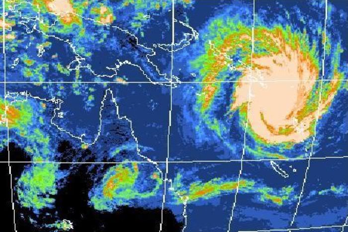
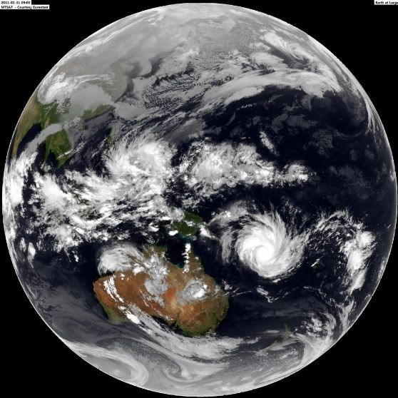
Queensland: na de overstromingen komen de cyclonen
2011 is slecht begonnen in het Australische Queensland. Eerst stond een groot deel van de staat onder water, nu raast de cycloon Anthony over de regio. En Anthony is nog maar de voorbode van de veel sterkere cycloon Yasi, die het gebied binnen enkele dagen zal treffen.
De tropische cycloon Anthony liet al een spoor van vernieling achter: daken werden losgerukt en hele straten kwamen blank te staan. Maar de echte vrees is er voor cycloon Yasi, die woensdag de kustlijn zal bereiken. Anna Bligh, premier van Queensland, vergeleek Anthony en Yasi al met 'David en Goliath'. 'Dit is een ernstige bedreiging voor onze regio', zei ze. 'Yasi wordt waarschijnlijk de krachtigste cycloon waar we ooit mee te maken kregen.'
Er wordt voorspeld dat Yasi tot 'categorie 4' zal behoren eens hij aan land komt. Dat betekent windstoten tot meer dan 250 kilometer per uur en maakt hem even sterk als orkaan Katrina, die in 2005 een groot deel van het Amerikaanse New Orleans met de grond gelijk maakte.
De ellende houdt dus voorlopig nog niet op voor Queensland, dat eerder deze maand werd getroffen door niets ontziende overstromingen. Zeker 35 mensen kwamen om het leven, 30.000 huizen kwamen blank te staan, wegen en spoorlijnen werden vernietigd en het economische leven stond stil.
Het zou nu al tot maart geduurd hebben voor de koolmijnen en de suikerindustrie (de voornaamste industrieën uit de regio, red.) weer op volle toeren konden draaien. Het is nog onduidelijk hoeveel roet de twee cyclonen daarbij in het eten zullen gooien.
bron
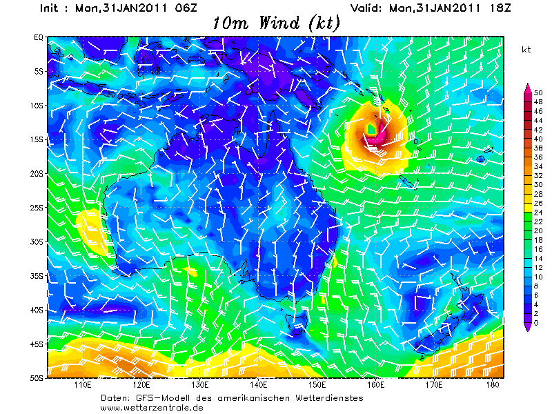
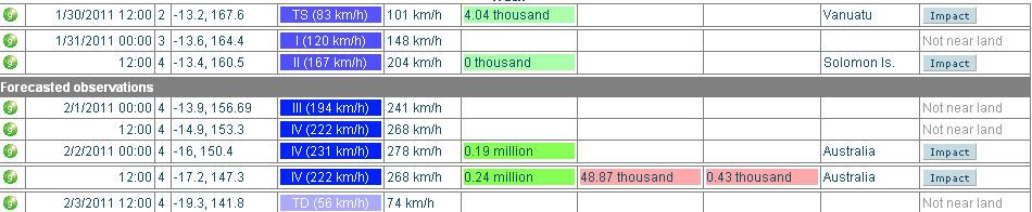
Het is nu een categorie 1 met windsnelheden tot net boven de 120 km/uur en windstoten tot 144 km/uur. Met een snelheid van 32 km/uur trekt de cycloon, in kracht toenemend, westwaarts richting Australie.

Het is nu een categorie 2. (windsnelheid 168 km/uur met windstoten tot net boven de 200 km/uur).
Neemt wel heel snel in kracht toe... morgen is het al een categorie 4.
[ Bericht 28% gewijzigd door #ANONIEM op 31-01-2011 15:05:52 ]
Neemt wel heel snel in kracht toe... morgen is het al een categorie 4.
[ Bericht 28% gewijzigd door #ANONIEM op 31-01-2011 15:05:52 ]
quote:Very dangerous Tropical Cyclone Yasi headed for Australia's flooded Queensland
With February nearly upon us, the traditional peak of the Southern Hemisphere tropical cyclone season is here, and the waters surrounding Australia have been exceptionally active over the past week. We had the year's first two Category 4 tropical cyclones last week, Tropical Cyclone Wilma and Tropical Cyclone Bianca. Wilma passed over American Samoa as a strong tropical storm, and hit Tonga as a Category 3 storm, causing substantial damage to the islands, but no deaths or injuries. Wilma brushed New Zealand, bringing flooding and landslides to the North Island, and was the strongest tropical cyclone to affect that country in fourteen years, according to weatherwatch.co.nz. Tropical Cyclone Bianca skirted the west coast of Australia and dissipated before making landfall. Tropical Cyclone Anthony hit flood-ravaged Queensland, Australia, over the weekend, as a weak tropical storm with 40 - 50 mph winds. Fortunately, Anthony dropped only modest amounts of rain, and no new flooding disaster occurred in Queensland, which is struggling to recover from record floods. As reported in the latest Australian Bureau of Meteorology climate statement and flood summary, the past four months (September - December) have been the rainiest such period in Queensland's history, and the resulting flooding disaster has been Australia's most expensive natural disaster in history.
Queensland is in serious danger of renewed extreme flooding this week from Tropical Cyclone Yasi. Yasi has intensified to a Category 2 storm with 105 mph winds, and is undergoing a period of rapid intensification that is expected to take it to Category 4 strength. Yasi is expected to hit Queensland on Wednesday, probably as a major Category 3 or stronger storm. In addition the storm's damaging winds and storm surge, Yasi will bring torrential rains. The GFS model is predicting that Yasi will dump 5 - 10 inches of rain over a large swath of Queensland, which would likely cause destructive flooding.
One positive note: the European Center model was remarkably accurate predicting the formation of Yasi over a week in advance, so Queensland has had plenty of time to prepare for the arrival of the storm.
Wunderground

quote:Evacuations begin ahead of cyclone Yasi
Evacuations will begin today in Queensland as a severe cyclone is expected to strike the flood ravaged state.
Authorities are preparing as far north as Cooktown and as far south as Maryborough, with nursing homes in the danger zone and Whitsunday's Hamilton Island already evacuating.
Yasi is expected to be a severe category four cyclone when it crosses the coast on Wednesday evening, likely between Innisfail and Proserpine.
Advertisement: Story continues below
Daydream Island will evacuate guests and staff on Tuesday and Tourism Whitsundays is arranging extra flights out of nearby Proserpine to cope with numbers.
Ports from Cairns to Mackay will close by late on Tuesday and other resort islands are working on their evacuation plans.
Whether schools would need to close was still being considered.
Authorities warn a storm surge could occur between Innisfail and Mackay and residents in low-lying, waterfront areas should consider staying with friends from Tuesday.
The Bureau of Meteorology said the last cyclone of a similar magnitude to hit Queensland was category four Cyclone Larry in March 2006.
Larry left a trail of destruction including damage to 10,000 homes and a repair bill of more than a billion dollars.
Volgens mij is het landfallpunt naar het noorden opgeschoven. Volgens mij was het eerst meer richting Townsville en Bowen, nu bijna direct-hit met Cairns
Inderdaad ja. Larry heeft daar in 2006 ook al flink huisgehouden.quote:
Volgens mij is het landfallpunt naar het noorden opgeschoven. Volgens mij was het eerst meer richting Townsville en Bowen, nu bijna direct-hit met Cairns
quote:Main article: Cyclone Larry
Tropical Cyclone Larry struck areas to the south of Cairns at 7 a.m. on 20 March 2006. Cyclone Larry crossed land near the town of Innisfail, 100 km (62 mi) south of Cairns as a category five cyclone. It was downgraded to a category four cyclone shortly before midday, and further downgraded to a category three cyclone a few hours later. Wind gusts of up to 300 km/h (186 mph) were recorded around the Cairns region, with wind gusts up to 180 km/h (112 mph) reported in the city. It is estimated that about one in four houses in Cairns and surrounding areas were affected by Cyclone Larry
O jee, ANP heeft vertaald en heeft Yasi met Katrina vergeleken  Terwijl er toch duidelijk Wilma staat:
WeatherWatch.co.nz says that while Yasi has the same strength as Wilma it is much bigger in size. Wilma is about 2500kms in diameter. To compare, New Zealand is just 1500kms long.
WeatherWatch.co.nz says that while Yasi has the same strength as Wilma it is much bigger in size. Wilma is about 2500kms in diameter. To compare, New Zealand is just 1500kms long.
Weer of geen weer, altijd actueel www.onweer-online.nl

