WKN Weer, Klimaat en Natuurrampen
Lees alles over het onstuimige weer op onze planeet, volg orkanen en tornado's, zie hoe vulkanen uitbarsten en hoe Moeder Aarde beeft bij een aardbeving. Alles over de verwoestende kracht van onze planeet en tal van andere natuurverschijnselen.


Handige linkjes:
· Onweerlinks 'live'
· Stormvue-sites
· Cape en voorspellende kaarten
· Wolkenkaarten en foto's
· Diverse weersites
· Achtergrond informatie
· Golven en wind
· Buienradar Nederland
· Buienradar West Europa
Overige informatie:
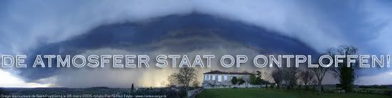
· Vorige delen 'De atmosfeer staat op ontploffen'
· Openingpost 'De atmosfeer staat op ontploffen'
Voeten in een bak met koud water blijft fijn met dit weer. 
Winnaar Agnes Kant knuffel 2010.
Indeed, what are the roots of western geometry? Nothing else but the Egyptian techniques of surveying property.
Indeed, what are the roots of western geometry? Nothing else but the Egyptian techniques of surveying property.
nix doen en toch weten niet...
Never Stop Exploring!
Life begins at the end of your comfort zone!
Follow me on Twitter: https://twitter.com/EdwinKr83 Instagram: https://www.instagram.com/edwinkr83/
Life begins at the end of your comfort zone!
Follow me on Twitter: https://twitter.com/EdwinKr83 Instagram: https://www.instagram.com/edwinkr83/
records gaan er niet gebroken worden denk ik, maar warm wordt het zekerquote:
[b]Op maandag 6 september 2010 00:28 schreef tong80 het volgende:[/b]
GVD Wat moet jij een trotse vader zijn :)
:P
GVD Wat moet jij een trotse vader zijn :)
:P

Misschien wordt dit zo'n topic waar je in gepost moet hebben.
Who the fuck can sleep with all this shit going on?
Geef mij maar een koude douche. Of effe met m'n kop onder de kouwe kraanquote:Op donderdag 1 juli 2010 19:58 schreef ethiraseth het volgende:
Voeten in een bak met koud water blijft fijn met dit weer.
Even wat anders;
Weet degene die daarover gaat, dat die links naar wiki.fok.nl niet meer kloppen?
Deze dus:
· Onweerlinks 'live'
· Stormvue-sites
· Cape en voorspellende kaarten
· Wolkenkaarten en foto's
· Diverse weersites
· Achtergrond informatie
· Golven en wind
Weet degene die daarover gaat, dat die links naar wiki.fok.nl niet meer kloppen?
Deze dus:
· Onweerlinks 'live'
· Stormvue-sites
· Cape en voorspellende kaarten
· Wolkenkaarten en foto's
· Diverse weersites
· Achtergrond informatie
· Golven en wind
Mooie Level 1 over heel Nederland
To summarize all that, we expect thunderstorm initiation already during the late morning hours from N-Spain all the way to the Netherlands, but more isolated to scattered in nature. Nevertheless, well organized multicells/isolated supercells are possible with an attendant large hail and strong wind gusts risk. Further east, over central/eastern France, a few thunderstorms may evolve during the peak time heating (afternoon hours) with abundant CAPE, weak shear and a very dry/mixed subcloud layer. Hence, isolated large hail and locally severe downbursts remain the main hazard, but too isolated for a level 1. Later on, during the evening hours, thunderstorms over N-Spain and SW-France increase in coverage and intensity, moving to the northeast. During the initiation stage, large hail (an isolated significant event is possible) and strong wind gusts remain the main hazard. Betimes, probably numerous thunderstorm clusters move over W-France northeastwards with an heavy rain, severe wind gusts and marginal hail risk. Also, an isolated tornado event is possible, given increasing LL directional shear and lower LCLs along the front itself. This activity also affects Belgium and the Netherlands during the night/morning hours. We decided to stick with a level 1 for now, as final moisture return and placement of the boundary remain a bit uncertain, but an upgrade may be performed later the day, if a more concentrated swath of severe events looks probable.
Stel je eens voor.quote:Op donderdag 1 juli 2010 21:57 schreef APK het volgende:
Misschien wordt dit zo'n topic waar je in gepost moet hebben.
Het knmi zegt alleen dit:
Dan zit ik wel goed.quote:In de avond is er in het zuidwesten kans op een onweersbui.
Life is Music
Ik ook.. Maar liever toch niet morgenavondquote:Op donderdag 1 juli 2010 22:35 schreef Stephan1237 het volgende:
In de avond is er in het zuidwesten kans op een onweersbui.
Ik zit ook goed
Mja, het is echt te warm nog steeds. Zelfs als ik op mijn balkon sta is het warm. 
Winnaar Agnes Kant knuffel 2010.
Indeed, what are the roots of western geometry? Nothing else but the Egyptian techniques of surveying property.
Indeed, what are the roots of western geometry? Nothing else but the Egyptian techniques of surveying property.

De hoogste temperatuur ooit op een KNMI-station in Nederland gemeten bedraagt 38,6 ºC op 23 augustus 1944 in Warnsveld.quote:
Wat is de hoogste temperatuur die ooit in NL is gemeten?
Doe mee met het voorspellen van het weer!
Weekvoorspelling | Week 12 (invullen tot 16-03 - 11:59)
Maandvoorspelling Maart (Inzendingen gesloten)
Jaarvoorspelling 2025 / 2026
Weekvoorspelling | Week 12 (invullen tot 16-03 - 11:59)
Maandvoorspelling Maart (Inzendingen gesloten)
Jaarvoorspelling 2025 / 2026
Dat gaan we hier morgen niet halen denk ik. Valt nu onder de gemeente Zutphen en ik woon er zo'n beetje 500m vandaan.quote:Op vrijdag 2 juli 2010 00:24 schreef Roel_Jewel het volgende:
[..]
De hoogste temperatuur ooit op een KNMI-station in Nederland gemeten bedraagt 38,6 ºC op 23 augustus 1944 in Warnsveld.
Never Stop Exploring!
Life begins at the end of your comfort zone!
Follow me on Twitter: https://twitter.com/EdwinKr83 Instagram: https://www.instagram.com/edwinkr83/
Life begins at the end of your comfort zone!
Follow me on Twitter: https://twitter.com/EdwinKr83 Instagram: https://www.instagram.com/edwinkr83/