WKN Weer, Klimaat en Natuurrampen
Lees alles over het onstuimige weer op onze planeet, volg orkanen en tornado's, zie hoe vulkanen uitbarsten en hoe Moeder Aarde beeft bij een aardbeving. Alles over de verwoestende kracht van onze planeet en tal van andere natuurverschijnselen.


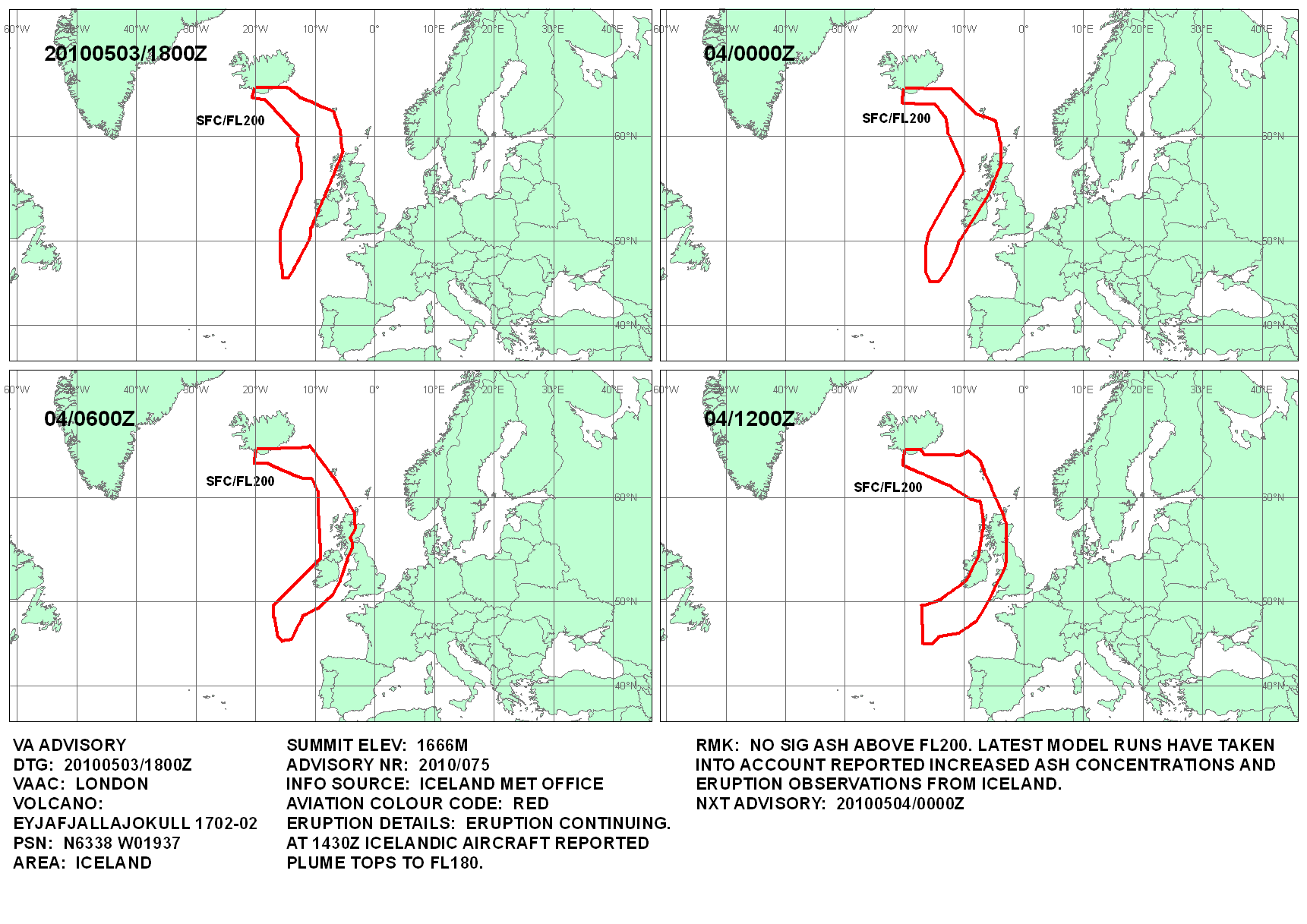
Weer 2 nieuwe rode stippen waarvan 1 dichtbij Katla.

Opgeblazen gevoel of winderigheid? Zo opgelost met Rennie!
Volgens mij zeggen die stippen niet zo heel veel.. althans, er volgt niet zo heel veel actie uit, behalve hier op het forum 
Vroegah, toen we voor een loempia nog naar Vietnam moesten.
Die stippen zeggen volgens mij meer dan omhooggaande grafiekjes.quote:Op donderdag 29 april 2010 15:51 schreef djayzz het volgende:
Volgens mij zeggen die stippen niet zo heel veel.. althans, er volgt niet zo heel veel actie uit, behalve hier op het forum
Opgeblazen gevoel of winderigheid? Zo opgelost met Rennie!

Stippen zijn bevingen, vlak voordat Eyjafjallajökull uit ging barsten zagen we veel bevingen, een cluster, bij elkaar, nu begint Katla te rommelen, als er nu weer een cluster bevingen is moet jij eens zien hoe gezellig het hier weer wordt.quote:Op donderdag 29 april 2010 15:51 schreef djayzz het volgende:
Volgens mij zeggen die stippen niet zo heel veel.. althans, er volgt niet zo heel veel actie uit, behalve hier op het forum
be nice or go away
dat bedoel ik.quote:Op donderdag 29 april 2010 15:57 schreef Frutsel het volgende:
En hoe vaak waren die stippen zichtbaar 'voordat' we hier gezellig zaten te keuvelen dan?
Vroegah, toen we voor een loempia nog naar Vietnam moesten.
Hmm, goed punt, maar zelfs op Icenews hadden ze het er over dat er bijna nooit zo veel bevingen bij elkaar zaten dus ik vermoed dat dit wel een teken zou zijn.quote:Op donderdag 29 april 2010 15:57 schreef Frutsel het volgende:
En hoe vaak waren die stippen zichtbaar 'voordat' we hier gezellig zaten te keuvelen dan?
be nice or go away
Misschien moet je sowieso niet uitgaan van alle vulcanologen hier op het forumquote:
Als de mensen die ervoor geleerd hebben al moeite hebben om te voorspellen wanneer een vulkaan uitbarst, lijkt het me niet dat wij hier op basis van een paar grafiekjes kunnen vertellen wanneer het wel gaat gebeuren.
Damn, those alien bastards are gonna pay for shooting up my ride!

Fok!kers zijn wel uitermate goed hoorquote:
[..]
Misschien moet je sowieso niet uitgaan van alle vulcanologen hier op het forum
Als de mensen die ervoor geleerd hebben al moeite hebben om te voorspellen wanneer een vulkaan uitbarst, lijkt het me niet dat wij hier op basis van een paar grafiekjes kunnen vertellen wanneer het wel gaat gebeuren.
Vroegah, toen we voor een loempia nog naar Vietnam moesten.
Hoiquote:Op donderdag 29 april 2010 16:49 schreef djayzz het volgende:
[..]
Fok!kers zijn wel uitermate goed hoor
Huilen dan.
Laatste dagen geen grafiekjes gevolgd, zal van 't weekend eens kijken als ik er weer aan toe kom en 't kreng is nog niet ontploft  .
.
Huilen dan.
Topic kan dus wel op slot, tot er meer nieuws isquote:
Ik moet jullie teleurstellen
Ik ben vannacht gewoon een paar keer uit me bed gevallen, en dat rommelt altijd een beetje....
Had een paar nachtmerries over betonnen ballen in me strot
Dus dan bepaald 1 mod wanneer iets 'nieuws' isquote:Op donderdag 29 april 2010 17:05 schreef Frutsel het volgende:
[..]
Topic kan dus wel op slot, tot er meer nieuws is
Opgeblazen gevoel of winderigheid? Zo opgelost met Rennie!
In IJsland zijn de geleerde het ook niet overeens waarom de slapende vulkanen zo actief zijn op Fok!.quote:Op donderdag 29 april 2010 16:46 schreef Drumfire het volgende:
[..]
Misschien moet je sowieso niet uitgaan van alle vulcanologen hier op het forum
Als de mensen die ervoor geleerd hebben al moeite hebben om te voorspellen wanneer een vulkaan uitbarst, lijkt het me niet dat wij hier op basis van een paar grafiekjes kunnen vertellen wanneer het wel gaat gebeuren.
Dan kan de Katlaah zelf een topic openen of nietquote:
[..]
Dus dan bepaald 1 mod wanneer iets 'nieuws' is
Daar hoef je niet eens een mod voor te zijn, zelfs ik kan datquote:Op donderdag 29 april 2010 17:31 schreef Katlaah het volgende:
[quote]
Kan, of ik wordt gewoon een mod en open dan weer dit topic
Dare to unleash my rage..
That's my secret Captain... I'm always angry...
There's nothing like a trail of blood, to find your way back home.
That's my secret Captain... I'm always angry...
There's nothing like a trail of blood, to find your way back home.
Huh?! Als Fruts een topic sluit kun jij dat weer openen?quote:Op donderdag 29 april 2010 18:17 schreef Burner82 het volgende:
[..]
Daar hoef je niet eens een mod voor te zijn, zelfs ik kan dat
be nice or go away
Nee, ik open dan een ander, maar toch weer hetzelfde topicquote:Op donderdag 29 april 2010 18:20 schreef kahaarin het volgende:
[..]
Huh?! Als Fruts een topic sluit kun jij dat weer openen?Ik dacht het toch niet hoor.
Dare to unleash my rage..
That's my secret Captain... I'm always angry...
There's nothing like a trail of blood, to find your way back home.
That's my secret Captain... I'm always angry...
There's nothing like a trail of blood, to find your way back home.
Dat kan! Geen punt.quote:Op vrijdag 30 april 2010 07:11 schreef Burner82 het volgende:
[..]
Nee, ik open dan een ander, maar toch weer hetzelfde topic
Ondertussen is het smeltwaterstroompje een smeltwatermeer geworden: http://eldgos.mila.is/eyjafjallajokull-fra-fimmvorduhalsi/
En nog een leuk berichtje:
quote:Many Volunteers Help Clean Ash in South Iceland
The cleaning begins. Around 100 people, including search and rescue team members, volunteered to help out with the ash cleaning last weekend. Photo by Benedikt Jóhannesson.
At least 100 people have volunteered to help clean ash from farms and other inhabited areas below the Eyjafjöll mountain range this weekend that were subject to the most extensive ash fall from the volcano in Eyjafjallajökull glacier.

be nice or go away
En hier een hele mooie fotoserie: http://gallery.me.com/thorleifur#100082&bgcolor=black&view=grid
be nice or go away
Status report van gisteren:
Sluiten lijkt me nog een beetje voorbarig Frutsel.quote:Eruption in Eyjafjallajökull - Status Report: 18:00 GMT, 29 April 2010
Icelandic Meteorological Office and Institute of Earth Sciences, University of Iceland
Compiled by: MJR / HB / MTG / SSJ / GS / BO
Based on: IMO seismic monitoring; IES-IMO GPS monitoring; IMO river gauges; web cameras of the eruption site from Vodafone, Mila, and Múlakot; IMO weather radar measurements; information from the local police; and aerial observations from a scientific flight with the Icelandic Coastguard (observation plane TF-SIF).
Eruption plume:
Height (a.s.l.): Not visible above clouds at 3.6–5.1 km (12–17,000 ft), but most likely below 3.6 km (12,000 ft). Before the overflight this morning, the eruption plume was not seen on radar images from Keflavík, nor on satellite images.
Heading: West and possibly southwest from the eruption site, but probably remaining close to Eyjafjallajökull due to light winds.
Colour: Cloud-cover obscured direct observations.
Tephra fallout: Light, fine-grained ash-fall reported in the morning during rain at
Ásólfsskáli, located 10.5 km south-west of the eruption site. Similar conditions also reported from a farm 12 km south-southwest of the eruption site at 15:00 GMT.
Lightning: Four lightning strikes detected over the summit of Eyjafjallajökull between 19:47 and 20:03 GMT on 28 April.
Noises: Booming sounds were reported yesterday evening, and again this morning, from Selsund, located ~40 km north-northwest of the eruption site.
Additional note: 16:13 GMT:Asulphur smell was detected at 3 km a.s.l. (10,000 ft) by pilots on a passenger flight 50–60 nautical miles east of Keflavík Airport.
Meltwater: Web-camera views show continued discharge of water from Gígjökull due to lava-ice interactions. On 28 April, the discharge of Markarfljót was measured twice at the old bridge, ~18 km downstream from Gígjökull. The flood that began at Gígjökull at ~11:30 GMT yesterday reached a peak discharge of 250 m3 s–1 two hours later at the bridge. Both yesterday and today, mean discharge from Gígjökull was 130–150 m3 s–1, which is higher than in previous days. The electrical conductivity of Krossá and Steinholtsá remains high (see report from 28 April for details).
Conditions at eruption site:
Airborne radar surveys from TF-SIF show a well-formed crater. Lava is spreading northward from the crater toward the head of Gígjökull. Ice continues to be melted by the propagating lava
front.
Seismic tremor: Intensity comparable to the preceding six days of eruptive activity.
Earthquakes: At 13:10 GMT, an Ml 1.5 earthquake was detected at shallow depth beneath the summit caldera; it is possible that this earthquake was a seismic explosion from the erupting crater.
GPS deformation: Horizontal displacement towards the centre of the volcano, in addition to vertical subsidence. These observations are consistent with deflation of a magma reservoir
beneath Eyjafjallajökull.
Magma flow: No measurements possible today.
Other remarks: No measurable geophysical changes within the Katla volcano.
Overall assessment: Plume elevations and magma discharge levels remain similar to the preceding six days of activity. Lava continues to flow north from the eruption site toward the head of the Gígjökull glacier. Today's explosive activity and ash production represents a fraction of conditions during the height of the eruption (14–17 April). Presently, there are no measurable indications that the eruption is about to end.
be nice or go away

Zeggen die drie aarbevingen op de Katla niets dan? 
http://en.vedur.is/earthquakes-and-volcanism/earthquakes/
http://en.vedur.is/earthquakes-and-volcanism/earthquakes/
Op zich niet veel, het is natuurlijk een actieve vulkaan (dwz met magmakamer e.d.) die hebben altijd wat activiteit, een beving kan domweg een uitstoot van wat overtollig gas oid zijn.quote:Op vrijdag 30 april 2010 15:17 schreef Mountainwatcher het volgende:
Zeggen die drie aarbevingen op de Katla niets dan?
http://en.vedur.is/earthquakes-and-volcanism/earthquakes/
Pas als er over een langere periode continu kleine oprispingen, bevingen en verschuivingen zijn icm een verandering in temperatuur en een ophoging van de grond door opbouw van magma gaat men denken aan bang worden voor een uitbarsting. En dan nog hoeft het geen grote te zijn, een uitbarsting is niet altijd enorm explosief compleet met pyroclastic flows en rondvliegende lavabommen, levensgevaarlijk gas en allesvernietigende aardschokken.
Nieuw dagraport van vanavond (altijd leuk nieuwe links. ) http://www2.norvol.hi.is/page/ies_Eyjafjallajokull_eruption
quote:Eruption in Eyjafjallajökull - Status Report: 17:00 GMT, 30 April 2010
Icelandic Meteorological Office and Institute of Earth Sciences, University of Iceland
Compiled by: MJR / MTG / FS / GS / SSJ
Based on: IMO seismic monitoring; IES-IMO GPS monitoring; IMO hydrological data; web cameras of the eruption site from Vodafone, Mila, and Múlakot; IMO weather radar measurements; information from scientists at Gígjökull; and aerial observations from the Icelandic Coastguard (observation plane TF-SIF).
Eruption plume:
Height (a.s.l.): Detected by weather radar at 15:20 GMT at an elevation of 2.8 km over the eruption site. TF-SIF observations at 15:40 GMT confirmed a steam plume rising to 4.5–5.1 km (15–17,000 ft). Clouds of ash at lower elevations observed drifting south of the eruption site.
Heading: South and south-west from the eruption site, but probably remaining close to Eyjafjallajökull due to light winds.
Colour: White (steam) clouds at higher elevation; dark grey (ash) clouds seen intermittently at lower elevation (see above).
Tephra fallout: Dark, fine-grained ash-fall reported over a 10 km region south of Eyjafjallajökull between Núpur and Skógar.
Lightning: No detections today over the eruption site (17:00 GMT).
Noises: Booming sounds reported in the vicinity of Eyjafjallajökull.
Additional note: Plumes of white plume were noticed over Gígjökull (15:40 GMT); this steam probably represents the position of the northward-flowing lava flow.
Meltwater: Web-camera views show continued discharge of water from Gígjökull due to lava-ice interactions. At 05:00 GMT a flood was detected leaving the Gígjökull lake basin. The flood reached a maximum discharge about two hours later at the old bridge over Markarfljót, ~18 km downstream. The flood was comparable in size to yesterday's gauged flows. At 14:00 GMT, meltwater flow beneath the bridge was ~200 m3 s–1. Discharge from Gígjökull decreased during the afternoon. Steaming blocks of rock are being deposited in the Gígjökull basin; these blocks are probably solidified lava from eruption. The electrical conductivity of Krossá and Steinholtsá remains high (see reports from 28 and 29 April for details).
Conditions at eruption site:
Airborne radar surveys from TF-SIF show a well-formed crater. Lava is spreading northward from the crater toward the head of Gígjökull. Ice continues to be melted by the propagating lava front.
Seismic tremor: Intensity comparable to the preceding six days of eruptive activity.
Earthquakes: No locatable seismicity detected beneath Eyjafjallajökull.
GPS deformation: Horizontal displacement towards the centre of the volcano, in addition to vertical subsidence. These observations are consistent with deflation of a magma reservoir beneath Eyjafjallajökull.
Magma flow: No measurements possible today.
Other remarks: No measurable geophysical changes within the Katla volcano.
Overall assessment: Plume elevations and magma discharge levels remain similar to the preceding seven days of activity. Lava continues to flow north from the eruption site and down the Gígjökull glacier. Today's explosive activity and ash production represents a fraction of conditions during the height of the eruption (14–17 April). Presently, there are no measurable indications that the eruption is about to end.
be nice or go away
Het lijkt wel of door de eruptie van EyFrutselNogwat de geologen op aarde wakker worden gemaakt..
quote:The eruption of Iceland’s Eyjafjallajökull set geologists on frantic runs to monitor possible volcano eruptions
Next on their radar is volcano Vesuvius located in the Bay of Naples, Italy.
Italian volcanologists are keeping track of two active sites after Guido Bertolaso, the president of Italy’s Civil Protection Department, announced that there is a possibility that the island of Ischia, a close neighbor of Vesuvius, will erupt very soon.
An estimated 650,000 people inhabit the slopes of Vesuvius and are at high risk. Due to the potentially detrimental effects of the island’s volcanos, the Italian minister called for a reevaluation of the emergency response team in the region around the two volcanoes. Up to 1 million people may need to be evacuated.
Katla, another volcano in Iceland is also under surveillance, according to recent speculations that Eyjafjallajökull might have upset Katla’s 92-year-long sleep.The reason for the prediction is historical evidence that the previous three times Eyjafjallajökull erupted, Katla followed.
“As bad as Eyjafjallajökull is, Katla could be much, much worse,” said Jay Miller, manager of Technical & Analytical Services at the A&M University in Texas, according to the Texas A&M University website.
Other volcanoes that are also getting special attention now include Mauna Loa, Hawaii; Sakurajima and Mount Hokodate-yama both in Japan; St. Helens, Washington; and Popocatepelt, Mexico.
Most of these volcanoes are among the most active in the world, so geologists have been watching them since their formation.
According to AFP, Bertolaso said, "Unfortunately, no one in the world can predict when a volcano will wake up … or predict an earthquake. There's a week or 10 days from the first signs until the moment it's too late
Lol @ deze zin:quote:Op vrijdag 30 april 2010 23:30 schreef Frutsel het volgende:
Het lijkt wel of door de eruptie van EyFrutselNogwat de geologen op aarde wakker worden gemaakt..
[..]
In het kader van op naar de volgende, next!quote:Next on their radar is volcano Vesuvius located in the Bay of Naples, Italy.
Wat me opvalt aan de dagrapporten is dat er steeds wordt gezegd dat er geen zicht is op het einde van de uitbarsting en dat er nog steeds veel water smelt. De doemdenkers van de klimaatlobby hadden het over het gevaar van verhoogde seismische activiteit als de gletsjers smelten omdat dit de druk op de aardkorst zou verminderen. Ik vraag me af of dat ook geldt voor IJsland. Het lijkt mij vergezocht.
be nice or go away
Op IJsland verwachten ze weer wat as:
De stoom/aswolken blijven voor het grootste gedeelte verstopt onder de wolken, ik vind het tijd voor opklaringen rondom IJsland.
@mountainwatcher: np.
[ Bericht 3% gewijzigd door kahaarin op 01-05-2010 16:10:47 ]
quote:Iceland volcano rumbles on, life does too
Posted on01 May 2010. Tags: Eyjafjallajokull, Iceland, Iceland volcano picture, volcano
The Iceland volcano erupting from Eyjafjallajokull is expected to cause ash fall in the southeast of Iceland today due to gentle north-westerly winds. Relatively small amounts of ash fell to the south of the volcano yesterday and Thursday, which temporarily stopped the farm clean-up operation.
Weather radar shows that the gas cloud reached around three kilometres high yesterday afternoon but the skies over the Eyjafjallajokull glacier began to clear again yesterday evening. Webcams pointing at the volcano showed clouds of steam coming from the rift on the Gigjokull glacial tongue, indicating that the lava running over the glacier is melting more ice under the brand new crust, RUV reports.
The ongoing eruption remains relatively stable and all Icelandic airports and main roads are open as usual, causing an increasing flow of visitors eager to see the volcano – although close-up viewing remains prohibited by police.
Photographer: Anders Peter Amsnæs / www.imagix.dk

De stoom/aswolken blijven voor het grootste gedeelte verstopt onder de wolken, ik vind het tijd voor opklaringen rondom IJsland.
@mountainwatcher: np.
[ Bericht 3% gewijzigd door kahaarin op 01-05-2010 16:10:47 ]
be nice or go away

Hmm, dat valt en staat met de Katla en of er een nieuwe krater opent onder de gletsjer, dan begint het feest namelijk van voor af aan. Het is nu stabiel, wel met nog immer verhoogde seismische rommels maar niet urgent paniek opwekkend. Zelfs de geleerden zijn het er over eens dat er nog niets anders van valt te zeggen als dat de uitbarsting stabiel is maar er nog geen zicht is op het einde van de uitbarsting of juist een nieuwe......quote:Op zaterdag 1 mei 2010 16:04 schreef Re het volgende:
ik moet over 2 weken weer 3x vliegen...
verkapte tvp dus
be nice or go away
Zo, opgeklaard, steamy as ever. (pun intended. )
http://eldgos.mila.is/eyjafjallajokull-fra-thorolfsfelli/
http://eldgos.mila.is/eyjafjallajokull-fra-thorolfsfelli/
be nice or go away


Het is nu helder, en het is zeker geen dooie boel.
http://eldgos.mila.is/eyjafjallajokull-fra-fimmvorduhalsi/
http://eldgos.mila.is/eyjafjallajokull-fra-fimmvorduhalsi/
Ziet er mooi uit 
Dare to unleash my rage..
That's my secret Captain... I'm always angry...
There's nothing like a trail of blood, to find your way back home.
That's my secret Captain... I'm always angry...
There's nothing like a trail of blood, to find your way back home.
Jammer dat we niet kunnen inzoomen
Dare to unleash my rage..
That's my secret Captain... I'm always angry...
There's nothing like a trail of blood, to find your way back home.
That's my secret Captain... I'm always angry...
There's nothing like a trail of blood, to find your way back home.
Dagrapport van gisteren:
Er is nog wel een beetje asuitstoot bij de orginele krateruitgang en de uitbarsting is op een vergelijkbaar niveau als de afgelopen dagen.
Het betreft dus geen 2e krater maar een goot die door de lava in de gletsjer is uitgesmolten, daarom is de 2e pluim zo wit, het is alleen maar stoom.quote:Eruption in Eyjafjallajökull - Status Report: 18:00 GMT, 1 May 2010
Icelandic Meteorological Office and Institute of Earth Sciences, University of Iceland
Compiled by: MJR / HB / FS / SSJ / BO
Based on: IMO seismic monitoring; IES-IMO GPS monitoring; IMO hydrological data; web cameras of the eruption site from Vodafone, Mila, and Múlakot; IMO weather radar measurements; information from scientists at Gígjökull; aerial observations from two scientific overflights: TF-SIF (10:30–11:00 GMT) and Eagle Air (16:40–17:15 GMT).
Eruption plume:
Height (a.s.l.): TF-SIF observations at 10:30 GMT confirmed an ash plume rising to 4–5.4 km (13–18,000 ft) near to Eyjafjallajökull. Clouds of ash at lower elevations observed drifting south-east of the eruption site. No verifiable detections from the weather radar at Keflavík Airport.
Heading: South-east from the eruption site. Plume track detected up to 400 km from the eruption site on AHRR and MODIS satellite imagery (12:11 GMT and 13:30 GMT).
Colour: Dark grey (ash) clouds observed up to 4 km a..s.l. (~13,000 ft). White (steam) plumes rising from Gígjökull, north of the eruption site.
Tephra fallout: Dark, coarser-grained ash-fall reported at Ytri Sólheimar (11:00 GMT), located 22 km south-east of Eyjafjallajökull.
Lightning: No detections today over the eruption site (18:00 GMT).
Noises: Booming sounds reported in the vicinity of Eyjafjallajökull.
Additional note: Plumes of white steam extend partway down Gígjökull. The uppermost plume represents the position of the northward-flowing lava flow, whereas the lower plumes are from hot meltwater.
Meltwater:
Discharge remains high from Gígjökull due to lava-ice interactions. Aerial observations of Gígjökull show that warm meltwater has carved a trench partway down the glacier. The electrical conductivity of Krossá and Steinholtsá remains high (see reports from 28–30 April for details).
Conditions at eruption site:
A 200-m-wide eruptive crater is visible within the ice cauldron. The rim of the crater appears to be ~30 m lower than the adjacent ice surface. Lava has propagated ~1 km north from the crater toward Gígjökull. Although steam is forming over the lava front, no large emissions of steam originate from the eruptive crater.
Seismic tremor:
Intensity comparable to the preceding eight days of eruptive activity.
Earthquakes:
No locatable seismicity detected beneath Eyjafjallajökull.
GPS deformation:
Horizontal displacement towards the centre of the volcano, in addition to vertical subsidence. These observations are consistent with deflation of a magma reservoir beneath Eyjafjallajökull.
Magma flow:
No measurements possible today.
Other remarks:
No measurable geophysical changes within the Katla volcano.
Overall assessment:
Plume elevations and magma discharge levels remain similar to the preceding eight days of activity. Lava continues to flow north from the eruption site and down the Gígjökull glacier. Today's explosive activity and ash production represents a fraction of conditions during the height of the eruption (14–17 April). Presently, there are no measurable indications that the eruption is about to end.
Er is nog wel een beetje asuitstoot bij de orginele krateruitgang en de uitbarsting is op een vergelijkbaar niveau als de afgelopen dagen.
be nice or go away

Was me paar dagen geleden al opgevallen dat er veel meer rook uit de buurt van de gletsjertong kwam, benieuwd of we straks ook lava gaan zien als de goot de rivier bereikt. Vanacht was het ook weer een mooi schouwspel.quote:Op zondag 2 mei 2010 12:06 schreef kahaarin het volgende:
Dagrapport van gisteren:
[..]
Het betreft dus geen 2e krater maar een goot die door de lava in de gletsjer is uitgesmolten, daarom is de 2e pluim zo wit, het is alleen maar stoom.
Er is nog wel een beetje asuitstoot bij de orginele krateruitgang en de uitbarsting is op een vergelijkbaar niveau als de afgelopen dagen.
Als deze stijging in de grafieken ziet... ik kan het helaas niet interpreteren. Wat denken jullie?
http://hraun.vedur.is/ja/Katla2009/gosplott.html
[ Bericht 0% gewijzigd door Mountainwatcher op 02-05-2010 22:19:16 ]
http://hraun.vedur.is/ja/Katla2009/gosplott.html
[ Bericht 0% gewijzigd door Mountainwatcher op 02-05-2010 22:19:16 ]
Ik denk dat het niks betekent!quote:Op zondag 2 mei 2010 21:48 schreef Mountainwatcher het volgende:
Als deze stijging in de grafieken ziet... ik kan het helaas niet interpreteren. Wat denken jullie?
http://hraun.vedur.is/ja/Katla2009/gosplott.html
Kijk eens naar de grote zwarte letters bovenaan de pagina die er sinds kort staan
Ik zag ze ook pas net
Opgeblazen gevoel of winderigheid? Zo opgelost met Rennie!
Nee, voor de Katla, maar voor de moeilijke naam ;-) Het ziet er nogal stijgend uit, sommige pieken zitten al hoger dan tijdens het begin van de eruptie
Hmm, misschien zo eens ff kijken.quote:Op zondag 2 mei 2010 17:19 schreef mouzzer het volgende:
[..]
Was me paar dagen geleden al opgevallen dat er veel meer rook uit de buurt van de gletsjertong kwam, benieuwd of we straks ook lava gaan zien als de goot de rivier bereikt. Vanacht was het ook weer een mooi schouwspel.
Over de grafieken, bedenk dat een verandering van windrichting al voor trillingen kan zorgen, ik denk dat het smeltwater is en ijs dat zich aan het zetten is, het dagrapport rept ook over lawaai van brekend ijs dus denk ik dat het niet in de berg zit maar dat het ligt aan het ijs dat er bovenop ligt.
be nice or go away
Eyjafjallajökull?quote:Op zondag 2 mei 2010 22:41 schreef Mountainwatcher het volgende:
Nee, voor de Katla, maar voor de moeilijke naam ;-) Het ziet er nogal stijgend uit, sommige pieken zitten al hoger dan tijdens het begin van de eruptie
be nice or go away
Dan zou ik nu even kijkenquote:Op zondag 2 mei 2010 23:03 schreef kahaarin het volgende:
[..]
Hmm, misschien zo eens ff kijken.
Over de grafieken, bedenk dat een verandering van windrichting al voor trillingen kan zorgen, ik denk dat het smeltwater is en ijs dat zich aan het zetten is, het dagrapport rept ook over lawaai van brekend ijs dus denk ik dat het niet in de berg zit maar dat het ligt aan het ijs dat er bovenop ligt.
http://eldgos.mila.is/eyjafjallajokull-fra-fimmvorduhalsi/
Jup, pwetty lights en warm water in het smeltwaterriviertje. Nog geen bevingen, die lava stroomt er gewoon rustig uit. Dit is het dag rapport van vandaag:quote:Op maandag 3 mei 2010 00:39 schreef mouzzer het volgende:
[..]
Dan zou ik nu even kijken
http://eldgos.mila.is/eyjafjallajokull-fra-fimmvorduhalsi/
Lol, hij snottert hete lava en de metingen komen waarschijnlijk van ijs-lava interactie of omstandigheden op de eruptiesite, klinkt logisch. Wat me opvalt is dat de patronen in de gletsjer wat veranderen. Ik weet niet wat dat betekent maar het lijkt me dat er dan dingen veranderen, of dat goed of slecht is weet ik niet....quote:Eruption in Eyjafjallajökull - Status Report: 21:00 GMT, 02 May 2010
Icelandic Meteorological Office and Institute of Earth Sciences, University of Iceland
Compiled by: MJR / MTG / FS / BO / SSJ / SH
Based on: IMO seismic monitoring; IES-IMO GPS monitoring; IMO hydrological data; web cameras of the eruption site from Vodafone, Mila, and Múlakot; IMO weather radar measurements; information from scientists at Gígjökull. [No scientific overflight today.]
Eruption plume:
Height (a.s.l.): Estimated from web-camera views and observers on the ground at an elevation of 4–5.4 km (13–18,000 ft). Clouds of ash at lower elevations observed drifting south-east of the eruption site. No verifiable detections from the weather radar at Keflavík Airport.
Heading: South-east from the eruption site. Plume track visible at least 200 km from the eruption site on MODIS (12:35 GMT) and EUMETSAT (17:15 GMT) satellite imagery.
Colour: Dark grey (ash) clouds observed over the eruptive site. White (steam) plumes rising from Gígjökull, north of the eruption site.
Tephra fallout: Moderate ash-fall reported in the village of Vík (12:00 GMT), located 40 km south-east of Eyjafjallajökull.
Lightning: No detections today over the eruption site (18:00 GMT).
Noises: Booming sounds heard during the night and throughout the day up to 40 km south-east of the eruption site.
Additional note: Plumes of white steam extend partway down Gígjökull. Lava appears to have advanced further down Gígjökull overnight. Aerial observations at 18:25 GMT confirmed a dense cloud of ash between 3–3.3 km a.s.l. (10,000–11,000 ft) at 60° N, 16° W (~470 km south-east of Iceland). London VAAC have been informed about this siting.
Meltwater:
Before 16:00 GMT, discharge levels at the old Markarfljóts bridge, ~18 km downstream from Gígjökull, were noticeably lower than yesterday's levels. Between 16:00–17:00 GMT, a meltwater pulse was detected at the bridge; the flood was comparable in size to earlier floods on 30 April. At 19:40 GMT, web-camera images of Gígjökull showed plumes of steam rising from the glacier edge. Additionally, steam is rising from the delta that occupies the lake basin, suggesting
the discharge of near-boiling meltwater.
Conditions at eruption site:
Explosive activity has increased somewhat over the last 2–3 days; mass flux in the plume is estimated at 10–20 tonnes/s. A scoria cone continues to form at the eruption site. Lava is propagating down Gígjökull and most of its energy is being used to melt ice. As lava advances down-glacier, the size of the ice canyon increases. Large plumes of steam are produced where lava is in contact with ice and meltwater.
Seismic tremor:
During the last 30 hours, tremor levels have intensified. This intensification could be due to lava-ice interactions within Gígjökull, or conditions at the eruption site.
Earthquakes:
No locatable seismicity detected beneath Eyjafjallajökull.
GPS deformation:
Horizontal displacement towards the centre of the volcano, in addition to vertical subsidence. In the last couple of days increased subsidence has been observed at stations closest to the eruptive crater. These observations are consistent with deflation of a magma reservoir beneath Eyjafjallajökull, although the deformation pattern has changed somewhat.
Magma flow:
See overall assessment.
Other remarks:
No measurable geophysical changes within the Katla volcano.
Overall assessment:
The eruption is mixed, with the lava-producing phase being larger than the explosive phase. During the last 2–3 days, the plume has been darker and wider than in the preceding week. Tephra fall-out in the vicinity of Eyjafjallajökull has increased. From the location of the steam plume over Gígjökull, lava has advanced over 3 km north of the eruption. Steam plumes over the glacier edge from 19:40 GMT suggest that lava may have advanced even further. A rough order-of-magnitude estimate of lava volume can be obtained from the dimensions of the ice canyon. This estimate gives a lava production rate of-the-order 20 m3 /s (i.e. 50 tonnes/s). The explosive phase may be 10–20 tonnes/s. The explosive phase has increased somewhat in intensity during the last few days. Presently, there are no measurable indications that the eruption is about to end.
Bron: http://www2.norvol.hi.is/page/ies_Eyjafjallajokull_eruption
be nice or go away
Het zijn vijf bevingen! Oei! Zie hier close-up van de kaart: http://en.vedur.is/earthq(...)uakes/myrdalsjokull/
Allemaal tegelijk rond 5 uur. Er wordt nog nergens over gesproken en er zijn te veel wolken om op de cams te kijken.quote:Op maandag 3 mei 2010 10:27 schreef Mountainwatcher het volgende:
Het zijn vijf bevingen! Oei! Zie hier close-up van de kaart: http://en.vedur.is/earthq(...)uakes/myrdalsjokull/
Op de grafiekjes nog immer veel activiteit, ik kan er de bevingen niet op terugvinden, geen idee wat en hoe, bij het dagrapport vanavond zullen we het wel lezen denk ik.
be nice or go away
Even een jaar oude kick
Mount St.Helens - Mei 1980 - Toen en Nu
KABOOEEEMM zei de vulkaan... één van de roemruchtigste uitbarstingen van de 20e eeuw
30 jaar geleden deze maand
Mount St.Helens - Mei 1980 - Toen en Nu
KABOOEEEMM zei de vulkaan... één van de roemruchtigste uitbarstingen van de 20e eeuw
30 jaar geleden deze maand
Nee, dit is nog niet eng, dan moet er meer gebeuren, de eerste dag van de uitbarsting was er bijna niets anders te zien dan stipjes, ik gok op een stuk gletjer dat is ingestort door zijn eigen gewicht boven de gaten die de lava hebben gemaakt, daarom wil ik graag beeld zien op de cams maar het is te bewolkt.quote:Op maandag 3 mei 2010 11:23 schreef Mountainwatcher het volgende:
Is het dan een clusterbeving? Die gaan toch meestal vooraf aan een nieuwe uitbarsting?
be nice or go away
Weet jij wat er gebeurt als er een stuk gletsjer gaat rommelen? Ik ook niet.quote:Op maandag 3 mei 2010 12:32 schreef Isdatzo het volgende:
Met een diepte van rond de 18km (4) en 2km (2) lijkt dat niet bepaald 't geval
be nice or go away

Ik welquote:
[..]
Weet jij wat er gebeurt als er een stuk gletsjer gaat rommelen? Ik ook niet.
Moet sowieso een héél groot stuk gletsjer zijn om boven de 1 op de richterschaal uit te komen. En dan niet op een diepte van 18km natuurlijk.
Huilen dan.
Lol, echt waar?!quote:Op maandag 3 mei 2010 12:50 schreef Isdatzo het volgende:
[..]
Ik wel.
Moet sowieso een héél groot stuk gletsjer zijn om boven de 1 op de richterschaal uit te komen. En dan niet op een diepte van 18km natuurlijk.
be nice or go away
Neuh, geen reden tot paniek. Misschien wel een reden om nog maar eens een optie op een vliegticket te nemen misschienquote:
[..]
Lol, echt waar?!
Huilen dan.
Oeh, dan wel foto's maken en hier posten!quote:Op maandag 3 mei 2010 14:59 schreef Isdatzo het volgende:
[..]
Neuh, geen reden tot paniek. Misschien wel een reden om nog maar eens een optie op een vliegticket te nemen misschien
quote:Increased Explosive Activity in Iceland Volcano
The explosive activity in the volcano in Eyjafjallajökull glacier seems to be increasing as the volcanic cloud has been larger and darker in color in the past few days than what it was the week prior, according to a new report from the Icelandic Meteorological Office.
The eruption in Eyjafjallajökull. Photo by Páll Stefánsson.
The same applies to the eruption activity. The report says this increase might be caused because of the interplay between ice and lava in the Gígjökull glacial tongue or changes to the volcanic channel. There is nothing that indicates that the eruption is ending, visir.is reports.
The water flow in the Markarfljót river, which originates in Gígjökull, increased temporarily yesterday and reached the same level as during the flooding of April 30.
Around 7:30 last night webcams showed a steam cloud at the edge of the glacial tongue, which indicates that the ice which has melted has heated up.
A dust storm raged in the area where the most ash had fallen below the Eyjafjöll mountain range yesterday afternoon, Morgunbladid reports.
A dense volcanic cloud filled with ash emerged from the clouds overhanging the mountains and blew across the farmstead of Raufarfell, while old ash was carried with the northwestern wind from the slopes of the mountains, blocking the view.
Close to midnight last night the lava flow from the volcano appeared to have reached the end of Gígjökull. Eyewitnesses told police in Hvolsvöllur that the lava is flowing by the edge of the glacial tongue. A red glow was seen at Gígjökull.

be nice or go away

Yup, had ook begrepen dat de lava ondertussen het einde van de gletsjer bereikt had. Da's dus een mooie bonus als ik ga .
* Isdatzo weer eens met reiscompagnon gaat overleggen.
* Isdatzo weer eens met reiscompagnon gaat overleggen.
Huilen dan.
Ja, dat las ik ook, ik hoop dat je reiscompagnon er ook zin in heeft.quote:Op maandag 3 mei 2010 17:00 schreef Isdatzo het volgende:
Yup, had ook begrepen dat de lava ondertussen het einde van de gletsjer bereikt had. Da's dus een mooie bonus als ik ga
* Isdatzo weer eens met reiscompagnon gaat overleggen.
oh ja, bron voor het artikel: http://icelandreview.com/icelandreview/daily_news/?cat_id=16539&ew_0_a_id=361709
be nice or go away
Maar die lava stroomt nu dus langzaam dat dal in als het goed begrijp ? Vet, kun je hem straks helemaal volgen tot aan de zee
Ja, jammer genoeg is het steeds bewolkt, als het helder was dan was het een veel spectaculairder gezicht geweest denk ik.quote:Op maandag 3 mei 2010 17:05 schreef Ermanon het volgende:
Maar die lava stroomt nu dus langzaam dat dal in als het goed begrijp ? Vet, kun je hem straks helemaal volgen tot aan de zee
Tot aan zee trouwens? Je weet dat de gletsjer 10km van de zee af is?

be nice or go away

Yup, zag 't op twitter voorbijkomen...quote:
Waarschijnlijk het luchtruim van Ierland weer dicht.
quote:@drivetimerte: Breaking News: IAA may be forced to restrict flights over Irish airspace because of volcanic ash #ashtag on air now @RTERadio1
quote:Vliegvelden Ierland morgen gesloten
Vanaf morgenvroeg is het vliegverkeer
van en naar Ierland niet mogelijk.De
Ierse luchtvaartautoriteiten hebben
besloten geen vluchten toe te laten
vanwege vulkaanas dat vanuit IJsland
over Ierland waait.Er staat morgen een
noordelijke wind.
Om 8.00 uur Nederlandse tijd wordt het
vliegverkeer stilgelegd.Vooralsnog
geldt het vliegverbod tot 14.00 uur
morgenmiddag,dan wordt de situatie
opnieuw bekeken.
Vluchten die op grote hoogte over
Ierland heengaan vallen niet onder het
vliegverbod.
Never in the entire history of calming down did anyone ever calm down after being told to calm down.
Yup, dagrapport heeft het ook over de verhoogde activiteit.quote:
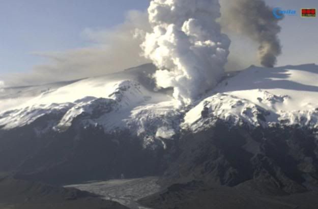
Hmm, ik krijg een beetje een snelkookpan idee, alle ingredienten zijn er, stoom, een hittebron en een vat. (de berg zelf)quote:Eruption in Eyjafjallajökull - Status Report: 16:00 GMT, 03 May 2010
Icelandic Meteorological Office and Institute of Earth Sciences, University of Iceland
Compiled by: Sigurlaug Hjaltadóttir, Freysteinn Sigmundsson, Björn Oddsson, Sigrún Hreinsdóttir, Þórdís Högnadóttir.
Based on: IMO seismic monitoring; IES-IMO GPS monitoring; IMO hydrological data; web cameras of the eruption site from Vodafone; IMO weather radar measurements, MODIS satellit image; information from scientists at Gígjökull, information from the Icelandic Coast Guard flight.
Eruption plume:
Height (a.s.l.): Largest plumes observed at 5-5,5 km height (17-18,000 ft) estimated from the Icelandic Coast Guard (ICG) flight at 14:30. The plume has also been observed on IMO's weather radar at 4.0-5.2 km height between 13:00 and 15:00 GMT. The plume rises higher after large explosions.
Heading: East-south-east to south-east from the eruption site. Plume track clearly visible at least 200 km from the eruption site and probably another 200 further to the SE on MODIS (11:20 GMT) satellite imagery.
Colour: Observation from ICG-flight: Dark grey (ash) clouds observed over the eruptive site. White (steam) plumes rising from Gígjökull otulet glacier, north of the eruption site (similar as yesterday).
Tephra fallout: Moderate ash-fall reported in Álftaver, 65-70 km east-south-east of Eyjafjallajökull (07:00-10:00 GMT. An ash cloud also observed over village of Vík (10:00 GMT), 40 km south-east of Eyjafjallajökull.
Lightning: No detections today over the eruption site (16:00 GMT).
Noises: Scientists working at Gígjökull regularly hear explosions and booming sounds and feel the ground vibrate. The vibrations are not felt in 3-4 km distance.
Additional note: The scientists at Gígjökull experienced discomfort due to gas.
Meltwater: Today water temperature at the Markarfljot bridge was measured 11°C but about 3°C in a 2 km distance from Gígjökull. Water is flowing on both sides of the glacier and pulses of meltwater flow down the channels every 10 minutes or so (according to scientists at Gígjökull). Water level gauge at Gígjökull also records the pulses. Temperature measurements at Markarfljot bridge show a pulse of water temperature up to 17°C at 06:00 GMT this morning and another smaller pulse reaching about 15°C between 08:00 and 09:00. Water temperature has now dropped down below 4°C.
Conditions at eruption site: The eruption site was seen on a vido camera around noon (13:00 GMT). Dark ash clouds propagating eastwards. The lava is probably still propagating down Gígjökull producing more meltwater and steam.
Seismic tremor: Tremor levels intensified last night (2 May) and have remained high since. This intensification is seen in the frequency range 0,5-2 Hz but not above 2Hx (2-4 Hz).
Earthquakes: A few earthquakes occurred early this morning. They seem to be located at about 18 km depth just south of the eruption site.
GPS deformation: Horizontal displacement towards the center of Eyjafjallajökull volcano. Vertical displacement at stations closest to the eruption site had indicated increased subsidence rate in the last few days but now the deformation is similar as before 29. April.
Other remarks: No measurable geophysical changes within the Katla volcano.
Overall assessment: The overall activity has not changed much since yeasterday (from the last report). Presently there are no indications that the eruption is about to end.
Sorry, weer bron vergeten: http://www2.norvol.hi.is/page/ies_Eyjafjallajokull_eruption
be nice or go away
Allerlei vreemde lichtstrepen op de camcorder van Hvolvelli, zijn dat een soort bliksem schichten of wat kan het anders zijn 
Condens op de lensquote:Op dinsdag 4 mei 2010 00:50 schreef smeltwater het volgende:
Allerlei vreemde lichtstrepen op de camcorder van Hvolvelli, zijn dat een soort bliksem schichten of wat kan het anders zijn
Mooi gezicht maar niet waar ik naar wilde klijken
[ Bericht 100% gewijzigd door smeltwater op 04-05-2010 01:03:30 ]
[ Bericht 100% gewijzigd door smeltwater op 04-05-2010 01:03:30 ]
Ondergaande zon in de lens, geen paniek.quote:Op dinsdag 4 mei 2010 00:54 schreef smeltwater het volgende:
Het ziet er heel vreemd uit ik hoop dat iemand die er verstand van heeft dit ook ziet en uitleg kan geven.
be nice or go away
Ik hoorde het radio journaal geen vlucht verkeer, dacht meteen ff kieken hier en verrek, weer wat activiteit enzo.
[b]Hobbelicious is back!
[/b]
[/b]
Ja echt vervelend, nu moet het daar mooi weer zijn en dan blijven die bewolking en mist maar hangen.quote:
Lol, had je dat nog niet eerer gezien?quote:Op dinsdag 4 mei 2010 09:08 schreef Isdatzo het volgende:
http://hraun.vedur.is/ja/Katla2009/stodvaplott.html
Ahaha dat zinnetje bovenaan de pagina
Nieuwe link: http://www.metoffice.gov.(...)no/volcano_blog.html
Dit is een blogger die post op de John Seach manier, John Seach is nu op IJsland als het goed is dus twittert hij niet.
be nice or go away
Neuh, afgelopen dagen niet zo heel veel tijd gehadquote:
[..]
Lol, had je dat nog niet eerer gezien?
Joah was 'm eerder ook al eens tegengekomen.. hij geeft wel aardige samenvattingen.quote:Nieuwe link: http://www.metoffice.gov.(...)no/volcano_blog.html
Dit is een blogger die post op de John Seach manier, John Seach is nu op IJsland als het goed is dus twittert hij niet.
Huilen dan.
Mgoed, nog even over die aardbevingen.. dat kan eigenlijk maar 2 dingen betekenen:
1. Er komt meer lava omhoog op grote diepte waardoor de druk op de rotsbodem toeneemt tot 'ie breekt. Voila, aardbeving.
2. De lava zakt terug waardoor de bodem inzakt en breekt. Voila, aardbeving.
Dat laatste komt wel overeen met de gpsmetingen die laten zien dat de bodemdaling nog steeds doorzet alleen niet met de toegenomen activiteit die nu toch echt plaatsvindt.
Alhoewel, in geval van optie 2 zou je de aardbevingen op een geringere diepte verwachten eigenlijk.
Huilen dan.
vlak in deze gassen niet uit, die kunnen ook best voor opschudding zorgen.quote:Op dinsdag 4 mei 2010 11:21 schreef Isdatzo het volgende:
Mgoed, nog even over die aardbevingen.. dat kan eigenlijk maar 2 dingen betekenen:
1. Er komt meer lava omhoog op grote diepte waardoor de druk op de rotsbodem toeneemt tot 'ie breekt. Voila, aardbeving.
De lavakomt er ook nog uit natuurlijk, daardoor verschilt de druk op de aardkorst af en toe. Hoe dan ook, de uitbarsting is nog niet over, ik vind de recente bevingen en hernieuwde intensiteit best wel een aandachtspuntje.quote:2. De lava zakt terug waardoor de bodem inzakt en breekt. Voila, aardbeving.
Dat laatste komt wel overeen met de gpsmetingen die laten zien dat de bodemdaling nog steeds doorzet alleen niet met de toegenomen activiteit die nu toch echt plaatsvindt.
Alhoewel, in geval van optie 2 zou je de aardbevingen op een geringere diepte verwachten eigenlijk.
Oh, weather forecast geeft opklaringen, wie weet kunnen we straks af en toe zien wat er gebeurt op de enige overgebleven webcam. http://en.vedur.is/weather/forecasts/areas/#view=table
be nice or go away
Maar op 18km diepte is dat niet echt iets om rekening mee te houdenquote:
[..]
vlak in deze gassen niet uit, die kunnen ook best voor opschudding zorgen.
Maar bij het afnemen van druk zie je meestal geen aardbevingen omdat de bodem dan toch min of meer 'rustig' inzakt. Mja, blijft lastig om precies te achterhalen waardoor die aardbevingen ontstaan.quote:[..]
De lavakomt er ook nog uit natuurlijk, daardoor verschilt de druk op de aardkorst af en toe. Hoe dan ook, de uitbarsting is nog niet over, ik vind de recente bevingen en hernieuwde intensiteit best wel een aandachtspuntje.
Beetje speculatie: die bevingen kunnen oorzaak of gevolg zijn van het vinden van een nieuwe doorgang en evt. menging van hete basaltlava met oudere lavareservoirs (ryoliet of andere lava op silicabasis) kan voor een nieuw spectakelstuk zorgen.
Huilen dan.
aardbevingen van 1-2 op Richter is toch meestal niet meer dan een vrachtwagen die voorbij rijdt qua intentie?
04-08-11, 02-02-12, 20-06-14, 13-08-15
Aha, het rommelt weer daar. Ik lees weer even mee
Dus dit is niets anders dan een TVP
Dus dit is niets anders dan een TVP
'Please don't sit on my imaginaire friend'
Joah, je merkt er niet veel van maar ook om een kleine aardbeving te veroorzaken is een enorme hoeveelheid energie nodigquote:Op dinsdag 4 mei 2010 12:01 schreef Re het volgende:
aardbevingen van 1-2 op Richter is toch meestal niet meer dan een vrachtwagen die voorbij rijdt qua intentie?
Huilen dan.
Ja dan trillen je ruiten, maar de laatste beving was 1 van 2,9.quote:Op dinsdag 4 mei 2010 12:01 schreef Re het volgende:
aardbevingen van 1-2 op Richter is toch meestal niet meer dan een vrachtwagen die voorbij rijdt qua intentie?
Dat is al wat meer als een vrachtwagen.
Nee, dat klopt, de meer aan de oppervlakte gesignaleerde bevingen wel. Lol, het zou wat zijn, op 18 km diepte.quote:Op dinsdag 4 mei 2010 11:59 schreef Isdatzo het volgende:
[..]
Maar op 18km diepte is dat niet echt iets om rekening mee te houden
Van wat ik heb begrepen kan er, als er op een gegeven moment veel lava uit komt, een beving ontstaan door het weer opvullen van het 'tekort' aan lava. Categorietje wet van de communicerende vaten.quote:Maar bij het afnemen van druk zie je meestal geen aardbevingen omdat de bodem dan toch min of meer 'rustig' inzakt. Mja, blijft lastig om precies te achterhalen waardoor die aardbevingen ontstaan.
Ja, iig een andere samenstelling van de aswolk/gassen die vrijkomen. Wat ik me eigenlijk ook afvroeg, stel dat de lopening, die nu wordt uitgehold door de lava, instort, dan kan er toch weer opnieuw een situatie ontstaan waarbij de kratermond onder water komt te staan? Ik bedoel eigenlijk dat er dan weer een boel water in terecht kan komen? Dan zouden we weer terug bij af zijn....quote:Beetje speculatie: die bevingen kunnen oorzaak of gevolg zijn van het vinden van een nieuwe doorgang en evt. menging van hete basaltlava met oudere lavareservoirs (ryoliet of andere lava op silicabasis) kan voor een nieuw spectakelstuk zorgen.
be nice or go away
Het ijs rond de krater is nu wel zo'n beetje helemaal weg, daar valt weinig aan in te storten. De lava die onder 't ijs doorglijdt, tja als daar water en ijs op komt krijg je vooral veel stoom en smeltwater. Dat gebeurt nu al. En dat smeltwater stroomt mooi de berg af  .
.
Huilen dan.
De Ierse luchthavens gaan om 14.00 uur Nederlandse tijd weer open. Dat maakte de Ierse luchtverkeersleiding dinsdag bekend.
De autoriteiten besloten het vliegverkeer vanaf 08.00 uur stil te leggen, omdat er te veel vulkaanas uit IJsland in de atmosfeer aanwezig was. De luchtverkeersleiding houdt de komende dagen een vinger aan de pols om te zien of de luchthavens open kunnen blijven.
Vorige maand werd het vliegverkeer in grote delen van Europa een week lang ontregeld na een vulkaanuitbarsting op IJsland.
We kunnen weer vliegen
Dare to unleash my rage..
That's my secret Captain... I'm always angry...
There's nothing like a trail of blood, to find your way back home.
That's my secret Captain... I'm always angry...
There's nothing like a trail of blood, to find your way back home.
Als de aarde dan nog bestaat ga ik kijkenquote:Op dinsdag 4 mei 2010 12:49 schreef Isdatzo het volgende:
Zondag 21.00 special op NG over de ejfrutseljoekel.
Vroegah, toen we voor een loempia nog naar Vietnam moesten.
goeie tipquote:
Zondag 21.00 special op NG over de ejfrutseljoekel.
Net op het nieuws, vliegtuigen vanuit Ierland vertrekken niet.
Over Ierland vliegen kan dan weer wel, want zo hoog komt de as niet.
Edit: ik heb maar half geluisterd, ze vliegen nu wel weer blijkbaar.
Over Ierland vliegen kan dan weer wel, want zo hoog komt de as niet.
Edit: ik heb maar half geluisterd, ze vliegen nu wel weer blijkbaar.
Vliegvelden zijn inmiddels toch weer geopend?quote:
Net op het nieuws, vliegtuigen vanuit Ierland vertrekken niet.
Over Ierland vliegen kan dan weer wel, want zo hoog komt de as niet.
Zie edit..quote:Op dinsdag 4 mei 2010 14:03 schreef Roel_Jewel het volgende:
[..]
Vliegvelden zijn inmiddels toch weer geopend?
blame the painkillers, ik hoor alles maar half
Rechtsvoor in beeld bij bórólfsfelli camera begint hij nu ook een beetje stoom te blazen.
Was blijkbaar maar tijdelijk, maar kwam uit een rotsspleet.
Was blijkbaar maar tijdelijk, maar kwam uit een rotsspleet.


Voor elk wat wilsquote:
Ik zie witte rook, stoom en zwarte rook
[ afbeelding ]
Huilen dan.
Begint behoorlijk te roken daar, kan ik niet tegen op  Gaan we dan toch even knallen binnenkort, of gewoon wishful thinking
Er staat nu iemand voor de camera Ga eens aan de kant man!
Wel geweldig gezicht zo, jammer dat ik pas op z'n vroegst midden juli naar IJsland kan.
Wel geweldig gezicht zo, jammer dat ik pas op z'n vroegst midden juli naar IJsland kan.
Aantal vandaag (1+) 16 04-05-'10
Laatste kr. 1+ 1.3 04-05-'10 16:35
Laatste kr. 2+ 2.9 04-05-'10 03:42
Laatste kr. 3+ 3.1 27-04-'10 18:30
Laatste kr. 4+ 4.3 20-02-'10 14:59
Laatste kr. 5+ 5.1 14-07-'08 03:23
Laatste kr. 1+ 1.3 04-05-'10 16:35
Laatste kr. 2+ 2.9 04-05-'10 03:42
Laatste kr. 3+ 3.1 27-04-'10 18:30
Laatste kr. 4+ 4.3 20-02-'10 14:59
Laatste kr. 5+ 5.1 14-07-'08 03:23
Wow ziet er gaaf uit!quote:Op woensdag 5 mei 2010 01:17 schreef mouzzer het volgende:
http://eldgos.mila.is/eyjafjallajokull-fra-fimmvorduhalsi/
De lava is nu erg dichtbij!
Kan niet inschatten of het nu een grote uitbarsting is of gewoon iets wat doorsukkeld zeg maar..
Heb het niet helemaal gevolgd zeg maar.
[b]Hobbelicious is back!
[/b]
[/b]
Tis nu vooral heel erg mistig voor de cam
Dare to unleash my rage..
That's my secret Captain... I'm always angry...
There's nothing like a trail of blood, to find your way back home.
That's my secret Captain... I'm always angry...
There's nothing like a trail of blood, to find your way back home.
Dagrapport van gisteren:
http://www2.norvol.hi.is/page/ies_Eyjafjallajokull_eruptionquote:Eruption in Eyjafjallajökull - Status Report: 15:00 GMT, 04 May 2010
Icelandic Meteorological Office and Institute of Earth Sciences, University of Iceland
Compiled by: Sigurlaug Hjaltadóttir, Freysteinn Sigmundsson, Björn Oddsson, Sigrún Hreinsdóttir, Matthew J Roberts, Hjörleifur Sveinbjörnsson.
Based on: IMO seismic monitoring; IES-IMO GPS monitoring; IMO hydrological data; web cameras of the eruption site from Vodafone, Milan and Mulakot; IMO weather radar measurements, NOAA satellite image; information from an eye witness at Fljótshlíð (MJR), information from the Icelandic Coast Guard flight.
Eruption plume:
Height (a.s.l.): Plume observed at 5.8-6 km height (19-20,000 ft) estimated from the Icelandic Coast Guard (ICG) flight at 10:40 and 15:30 GMT. The plume has also been observed on IMO's weather radar at 5.2-5.4 km height between 13:05 and 14:00 GMT.
Heading: East-south-east to south-east from the eruption site. Plume track clearly visible up to 300-400 km distance from the eruption site on a noaa satellite image at 13:13 GMT.
Colour: Observation from web cameras and from pilots in ICG-flight: Dark grey ash plume observed over the eruptive site, larger than yesterday. White (steam) plumes rising from Gígjökull outlet glacier, north of the eruption site smaller than yesterday.
Tephra fallout: According to the police at Hvolsvöllur there was ash-fall in Álftaver and Meðalland, 65-80 km east-south-east of Eyjafjallajökull, where people could hardly see next farms (in a few kilometres distance).
Lightning: No detections today over the eruption site.
Noises: An eye witness in Fljótshlíð (9-10 N of eruption site) heard explosions every few seconds. He also hears seperate noises from Gígjökull outlet glacier.
Meltwater:
Water levels have been rather constant. Water temperature at Markarfljot bridge was low this morning (below 2°C) but seems to be rising (about 5°C at noon). Water level seems to be slightly decreasing.
Conditions at eruption site:
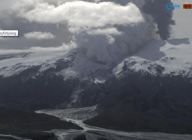
Explosive activity and ash production is strong and has increased since yesterday. Dark ash plume rises above the crater. Lava is still flowing northwards, forming a lava fall down the steep hill under Gígjökull, about 4 km north of the crater. Blue gas is seen rising from the lava and white steam plumes are seen somewhat lower and mark the front of the lava stream. Radar images from ICG-flight today show tunnels in Gígjökull increasing in size and continuing the build up of the cone at the crater. The size of the eruptive crater is 280 x 190 m. Lava splashes are thrown at least a few hundred meters into the air.
Seismic tremor:
Tremor levels decreased last night (3 May) and have decreased even further this morning at around 11:00 GMT. They now seem to be at a similar level as on 18 April.
Earthquakes:
Several earthquakes were detected beneath Eyjafjallajökull yesterday evening and early this morning. As yesterday, they seem to originate deep in the crust (14 -20 km).
GPS deformation:
Irregular oscillations in vertical component of stations next to the volcano.
Other remarks:
No measurable geophysical changes within the Katla volcano.
Overall assessment:
More explosive activity and ash production than was observed yesterday. Progression of the lava seems to be slower than yesterday. Presently there are no indications that the eruption is about to end.
be nice or go away
Hmm, luchthavens niet dicht maar wel geschrapte vluchten:
quote:Woensdag mogelijk driehonderd Europese vluchten geschrapt
05-05-2010
BRUSSEL - Ongeveer driehonderd van de geplande 29.000 Europese vluchten in Europa zullen woensdag (5 mei) waarschijnlijk worden geannuleerd. Dit als gevolg van het sluiten van het luchtruim boven Ierland en het westen van Schotland vanwege hoge concentraties vulkanische as afkomstig uit IJsland. Dat heeft Eurocontrol, de Europese luchtverkeersleider bekendgemaakt.
"Heel Ierland, het westen van Schotland en het noordwesten van Engeland kunnen hier last van hebben", aldus Eurocontrol in een verklaring. Vooral vluchten van en naar de luchthavens van Manchester en Liverpool kunnen hier volgens Eurocontrol door in het gedrang komen.
be nice or go away

3 nieuwe aardbevingen, waarvan 1 op de Katla! Zie kaart http://www.vedur.is/skjal(...)lftar/myrdalsjokull/

@ Roel_Jewel Weet je misschien wat dat betekent? Alvast bedankt!
[ Bericht 1% gewijzigd door Mountainwatcher op 05-05-2010 20:22:24 ]
[ Bericht 1% gewijzigd door Mountainwatcher op 05-05-2010 20:22:24 ]
Hoeft op zich niet veel te betekenen. Het zijn geen heel zware bevingen. Bovendien is de aarde daar natuurlijk nu letterlijk in beweging door de uitbarsting, mede door de reactie van lava in combinatie met ijs.quote:
@ Roel_Jewel Weet je misschien wat dat betekend? Alvast bedankt!
Waarvan 1tje richting de katlaquote:
Het zijn nu inmiddels 5 nieuwe beving http://en.vedur.is/earthq(...)uakes/myrdalsjokull/
Hier een mooie video waarbij de moeilijke naam beelden van 4 mei versneld worden getoond
[ Bericht 23% gewijzigd door Mountainwatcher op 05-05-2010 20:48:24 ]

[ Bericht 23% gewijzigd door Mountainwatcher op 05-05-2010 20:48:24 ]
nicequote:Op woensdag 5 mei 2010 20:20 schreef Mountainwatcher het volgende:
Hier een mooie video waarbij de moeilijk naam beelden van 4 mei versneld worden getoond
Als ik op sat 24 kijk lijkt het of de meeste damp op IJsland zelf wordt veroorzaakt.
http://www.sat24.nl/Eyjafjallajokull-volcano.aspx

http://www.sat24.nl/Eyjafjallajokull-volcano.aspx
He wat raar, de beving bij Katla is weggehaald... die zou toch gewoon van kleur moeten veranderen tot blauw en dan verdwijnen?? Weet iemand hoe dat zit?
http://en.vedur.is/earthq(...)uakes/myrdalsjokull/
http://en.vedur.is/earthq(...)uakes/myrdalsjokull/
al 24 schokjes vandaag 
Aardbevingen meer..
Aantal vandaag (1+) 24 05-05-'10
Laatste kr. 1+ 1.9 05-05-'10 17:51
Laatste kr. 2+ 2.2 05-05-'10 08:11
Laatste kr. 3+ 3.8 04-05-'10 20:40
Laatste kr. 4+ 4.3 20-02-'10 14:59
Laatste kr. 5+ 5.1 14-07-'08 03:23
Aardbevingen meer..
Aantal vandaag (1+) 24 05-05-'10
Laatste kr. 1+ 1.9 05-05-'10 17:51
Laatste kr. 2+ 2.2 05-05-'10 08:11
Laatste kr. 3+ 3.8 04-05-'10 20:40
Laatste kr. 4+ 4.3 20-02-'10 14:59
Laatste kr. 5+ 5.1 14-07-'08 03:23
Dit is trouwens een heel fijn forum en heel erg uptodate! http://scienceblogs.com/e(...)_eyjaf_explosive.php
Joah, vooral de comments zijn vaak erg interessant  .
.
Jammer dat ik de laatste tijd even geen tijd heb om 't allemaal even goed te volgen .
.
Jammer dat ik de laatste tijd even geen tijd heb om 't allemaal even goed te volgen
Huilen dan.
Dat gebeurd constant. Stipjes komen er soms opeens als geel bij ipv rood, en soms verdwijnen ze weer. Denk gewoon foutjes in sensoren/software/databases.quote:Op woensdag 5 mei 2010 21:36 schreef Mountainwatcher het volgende:
He wat raar, de beving bij Katla is weggehaald... die zou toch gewoon van kleur moeten veranderen tot blauw en dan verdwijnen?? Weet iemand hoe dat zit?
http://en.vedur.is/earthq(...)uakes/myrdalsjokull/
Opgeblazen gevoel of winderigheid? Zo opgelost met Rennie!
30-04-2010
Vulkaanuitbarsting IJsland: waarom?
Stof op de auto verklaart oorzaak vulkaanuitbarsting
Manfred van Bergen (Universiteit Utrecht) en collega’s onderzochten één gram as van de IJslandse vulkaan Eyjafjallajökull. Het blijkt dat een prop gesteente van de vorige serie uitbarstingen in 1821-1823 dé reden is van de grote aswolk van half april die het vliegverkeer lamlegde. Het vervolg van de uitbarsting zal daarom waarschijnlijk minder explosief zijn.
De uitbarsting van de Eyjafjallajökull vulkaan is inmiddels in kracht afgenomen. Een nauwkeurig inzicht in de samenstelling van de aswolk is van belang voor het vliegverkeer, voor het inschatten van gezondheidsrisico’s en om het verloop van de vulkaanuitbarsting te begrijpen. Vulkanoloog Manfred van Bergen (Universiteit Utrecht) is samen met collega’s Martyn Drury en Igor Nikogosian bezig de asdeeltjes in laboratoria te onderzoeken. De eerste resultaten laten zien wat je kunt leren van het stof op je auto…
In Nederland zijn slechts minieme hoeveelheden as op de grond terechtgekomen. De IJslandse as, die nu bestudeerd wordt in de Utrechtse laboratoria, heeft wel een heel bijzondere route naar Utrecht gevolgd. Bij toeval waren twee studenten, Annique van der Boon en Anouk Beniest vanwege een veldwerk voor hun bachelorscriptie in Engeland, juist op het moment dat daar de as neerkwam. Met een laag stof op hun huurauto reden ze terug naar Utrecht. De schoonmaakbeurt luidde een speurtocht naar de oorzaak van de vulkaanuitbarsting in.
Verspreiding van de aswolk op 15 april. Afbeelding: © Met Office
.Samenstelling van de “as van het kwaad”
De vulkanische as wordt met een electronen-microscoop en een electronen-microsonde geanalyseerd. Met deze instrumenten kunnen niet alleen de grootte en de vorm, maar ook de chemische samenstelling van zeer kleine stofdeeltjes vastgesteld worden.
De eerste resultaten laten zien dat de asdeeltjes maximaal zo’n 50 micrometer groot zijn, een paar uitzonderingen daargelaten (1 micrometer = 1/1000-ste millimeter). De korreltjes zijn heel gevarieerd van samenstelling. De overgrote meerderheid bestaat uit kristalletjes van zeker 10 verschillende mineralen, die gevormd moeten zijn bij geleidelijke afkoeling van heet magma. Ook werden minuscule gesteentefragmentjes aangetroffen. Een klein percentage van het stof bestaat uit vulkanisch glas. Dat ontstaat wanneer de afkoeling heel snel verloopt. De kristalvorm van de mineralen is vaak goed te herkennen. Een kleine hoeveelheid asdeeltjes is naaldvormig. De mineraal- en glasdeeltjes bestaan vooral uit de elementen silicium, aluminium, zuurstof, ijzer, magnesium, calcium, kalium, natrium, titanium en fosfor, bouwstenen die in wisselende verhoudingen aanwezig zijn.
Electronen-microcoop opname die grootte, vorm en veelsoortigheid van de asdeeltjes laat zien. De samenstelling is kenmerkend voor vulkanisch materiaal De lijn rechtsonder geeft een lengte van 50 micrometer aan.
.Waarom begon de tweede uitbarsting zo explosief?
De eerste eruptie op de flank van de vulkaan die op 20 maart begon verliep vrij rustig. Uit een spleet kwam silicium-arm, bazaltisch magma tevoorschijn dat zich als lavastromen in de directe omgeving verspreidde. De heftige tweede uitbarsting in het centrale deel van de vulkaan die op 14 april begon produceerde de aswolk. Niet alleen het water van de smeltende gletsjer en het vrijkomende vulkanische gas droegen bij aan de explosiviteit van de eruptie. Nu blijkt uit de samenstelling van de as ook dat er nog een andere factor in het spel was. Vrijwel alle gevonden mineraalsoorten (onder meer kwarts) kunnen niet in een bazaltisch magma ontstaan zijn maar wijzen op een rhyolitisch magma dat silicium-rijk en daardoor veel minder vloeibaar is. Deze eigenschap geeft doorgaans aanleiding tot grote explosiviteit.
Het silicium-rijke magma is vermoedelijk een semi-gestold restant dat bij de vorige uitbarsting in 1821-1823 in de vulkaan is blijven zitten. Het is ook mogelijk dat silicium-rijk gesteente in de berg door de hitte van het omhoogkomende bazaltische magma smolt. Diens gebruikelijke temperatuur van zo’n 1200 graden Celcius is daarvoor meer dan genoeg.
Electronen-microcoop opname met details van enkele asdeeltjes. De veldspaatkorrel in het midden laat een mooie kristalvorm zien. De lijn rechtsonder geeft een lengte van 10 micrometer aan.
.“Smoking gun” van een explosief mengsel
Hardnekkig speurwerk tussen de asdeeltjes levert inderdaad het bewijs op voor een samenspel tussen twee verschillende magma’s: één van de glasdeeltjes blijkt vrijwel dezelfde samenstelling te hebben als het silicium-arme bazaltische magma van de eerdere uitbarsting op de flank. Andere glasdeeltjes bevatten veel meer silicium. Samen met de mineraalkristallen vertegenwoordigen ze het silicium-rijke magma, het hoofdbestanddeel van het mengsel.
Met deze voorlopige resultaten, verkregen uit nog geen volle gram as, en de waarnemingen ter plaatse laat het machtige ontwaken van de Eyjafjallajökull vulkaan zich volgens een aannemelijk scenario verklaren. Bazaltisch magma, afkomstig van grote diepte baande zich gedurende langere tijd een weg naar boven. Waarschijnlijk was dit proces al jaren aan de gang. De vrije doorgang naar buiten werd belemmerd door een silicium-rijke ‘prop’ van sterk gekristalliseerd magma of volledig gestold gesteente uit een eerdere periode van activiteit. Deze barrière bevond zich in het centrale deel van de vulkaan ergens onder de gletsjer.
Het geaccumuleerde bazaltische magma vond een eerste weg naar buiten via een zijwaartse route. Dit leidde tot de eerste eruptie op de flank van de vulkaan. Enkele weken later was de “prop” zover aangetast en onder druk gezet dat hij het begaf en verbrijzelde. Deze latere uitbarsting op de top van de vulkaan produceerde uiteindelijk de aswolk die het vliegverkeer lamlegde. Dat daarbij ook flink wat zwaveldioxide de lucht in ging blijkt uit een verhoogde concentratie aan opgelost sulfaat die in spoelwater van het asmonster werd gemeten.
Minuscule kristalletjes van een bonte verzameling mineralen
Volgens eerste voorlopige resultaten bestaat het onderzochte monster van de aswolk uit minuscule kristalletjes van een bonte verzameling mineralen. Fragmentjes vulkanisch glas met verschillende samenstellingen vormen een veel kleiner bestanddeel.
Het overgrote merendeel van de asdeeltjes is niet afkomstig van silicium-arm bazaltisch magma waar IJsland zo bekend om staat. Het zijn fragmenten van silicium-rijk materiaal uit een vorige actieve periode dat zich in de vulkaan bevond. Dit verklaart waarom de tweede eruptie in het centrale deel van de vulkaan zo heftig begon en de aswolk kon ontstaan.
Nu deze “oude” barrière is opgeruimd kan het bazaltische magma makkelijker naar buiten. Het ligt daarmee voor de hand dat de verminderde explosiviteit die we nu zien van blijvende duur zal zijn, waarschijnlijk tot de activiteit volledig ophoudt.
De manier waarop de Eyjafjallajökull vulkaan tot uitbarsting kwam past in het gedragspatroon van andere vulkanen in de “Eastern Volcanic Zone” van IJsland.
De buurvulkaan Katla heeft in het verleden ook twee soorten magma geproduceerd. Een vergelijkbaar scenario kan daar leiden tot nog veel heftiger uitbarstingen en veel grotere aswolken. De vraag is wanneer dat gebeurt …
Zie ook:
•Klimaatgevolgen uitbarsting IJsland beperkt (Kennislinkartikel)
•As vulkaan IJsland beperkt luchtvaart (Kennislinkartikel)
•Dagelijkse update over de Eyjafjallajökull (technisch Engels)
•Vulkanen (Kennislinkdossier)
•Vulkanen – Directe en indirecte gevolgen (Kennislinkartikel)•Vulkaanobservatie en economie (Kennislinkartikel)
•Vulkanen – Opbouw, vorm/type en locatie (Kennislinkartikel)
•Supervulkanen bedreigen de aarde (Kennislinkartikel van Explore Magazine)
•Plaattektoniek(Kennislinkdossier)
•Vulkaan op IJsland zorgt voor mooie beelden en problemen (VU)
*IJslands vulkaanas helpt bij klimaatvoorspellingen (Universiteit Utrecht)
(Kennislink)
Vulkaanuitbarsting IJsland: waarom?
Stof op de auto verklaart oorzaak vulkaanuitbarsting
Manfred van Bergen (Universiteit Utrecht) en collega’s onderzochten één gram as van de IJslandse vulkaan Eyjafjallajökull. Het blijkt dat een prop gesteente van de vorige serie uitbarstingen in 1821-1823 dé reden is van de grote aswolk van half april die het vliegverkeer lamlegde. Het vervolg van de uitbarsting zal daarom waarschijnlijk minder explosief zijn.
De uitbarsting van de Eyjafjallajökull vulkaan is inmiddels in kracht afgenomen. Een nauwkeurig inzicht in de samenstelling van de aswolk is van belang voor het vliegverkeer, voor het inschatten van gezondheidsrisico’s en om het verloop van de vulkaanuitbarsting te begrijpen. Vulkanoloog Manfred van Bergen (Universiteit Utrecht) is samen met collega’s Martyn Drury en Igor Nikogosian bezig de asdeeltjes in laboratoria te onderzoeken. De eerste resultaten laten zien wat je kunt leren van het stof op je auto…
In Nederland zijn slechts minieme hoeveelheden as op de grond terechtgekomen. De IJslandse as, die nu bestudeerd wordt in de Utrechtse laboratoria, heeft wel een heel bijzondere route naar Utrecht gevolgd. Bij toeval waren twee studenten, Annique van der Boon en Anouk Beniest vanwege een veldwerk voor hun bachelorscriptie in Engeland, juist op het moment dat daar de as neerkwam. Met een laag stof op hun huurauto reden ze terug naar Utrecht. De schoonmaakbeurt luidde een speurtocht naar de oorzaak van de vulkaanuitbarsting in.

Verspreiding van de aswolk op 15 april. Afbeelding: © Met Office
.Samenstelling van de “as van het kwaad”
De vulkanische as wordt met een electronen-microscoop en een electronen-microsonde geanalyseerd. Met deze instrumenten kunnen niet alleen de grootte en de vorm, maar ook de chemische samenstelling van zeer kleine stofdeeltjes vastgesteld worden.
De eerste resultaten laten zien dat de asdeeltjes maximaal zo’n 50 micrometer groot zijn, een paar uitzonderingen daargelaten (1 micrometer = 1/1000-ste millimeter). De korreltjes zijn heel gevarieerd van samenstelling. De overgrote meerderheid bestaat uit kristalletjes van zeker 10 verschillende mineralen, die gevormd moeten zijn bij geleidelijke afkoeling van heet magma. Ook werden minuscule gesteentefragmentjes aangetroffen. Een klein percentage van het stof bestaat uit vulkanisch glas. Dat ontstaat wanneer de afkoeling heel snel verloopt. De kristalvorm van de mineralen is vaak goed te herkennen. Een kleine hoeveelheid asdeeltjes is naaldvormig. De mineraal- en glasdeeltjes bestaan vooral uit de elementen silicium, aluminium, zuurstof, ijzer, magnesium, calcium, kalium, natrium, titanium en fosfor, bouwstenen die in wisselende verhoudingen aanwezig zijn.

Electronen-microcoop opname die grootte, vorm en veelsoortigheid van de asdeeltjes laat zien. De samenstelling is kenmerkend voor vulkanisch materiaal De lijn rechtsonder geeft een lengte van 50 micrometer aan.
.Waarom begon de tweede uitbarsting zo explosief?
De eerste eruptie op de flank van de vulkaan die op 20 maart begon verliep vrij rustig. Uit een spleet kwam silicium-arm, bazaltisch magma tevoorschijn dat zich als lavastromen in de directe omgeving verspreidde. De heftige tweede uitbarsting in het centrale deel van de vulkaan die op 14 april begon produceerde de aswolk. Niet alleen het water van de smeltende gletsjer en het vrijkomende vulkanische gas droegen bij aan de explosiviteit van de eruptie. Nu blijkt uit de samenstelling van de as ook dat er nog een andere factor in het spel was. Vrijwel alle gevonden mineraalsoorten (onder meer kwarts) kunnen niet in een bazaltisch magma ontstaan zijn maar wijzen op een rhyolitisch magma dat silicium-rijk en daardoor veel minder vloeibaar is. Deze eigenschap geeft doorgaans aanleiding tot grote explosiviteit.
Het silicium-rijke magma is vermoedelijk een semi-gestold restant dat bij de vorige uitbarsting in 1821-1823 in de vulkaan is blijven zitten. Het is ook mogelijk dat silicium-rijk gesteente in de berg door de hitte van het omhoogkomende bazaltische magma smolt. Diens gebruikelijke temperatuur van zo’n 1200 graden Celcius is daarvoor meer dan genoeg.

Electronen-microcoop opname met details van enkele asdeeltjes. De veldspaatkorrel in het midden laat een mooie kristalvorm zien. De lijn rechtsonder geeft een lengte van 10 micrometer aan.
.“Smoking gun” van een explosief mengsel
Hardnekkig speurwerk tussen de asdeeltjes levert inderdaad het bewijs op voor een samenspel tussen twee verschillende magma’s: één van de glasdeeltjes blijkt vrijwel dezelfde samenstelling te hebben als het silicium-arme bazaltische magma van de eerdere uitbarsting op de flank. Andere glasdeeltjes bevatten veel meer silicium. Samen met de mineraalkristallen vertegenwoordigen ze het silicium-rijke magma, het hoofdbestanddeel van het mengsel.
Met deze voorlopige resultaten, verkregen uit nog geen volle gram as, en de waarnemingen ter plaatse laat het machtige ontwaken van de Eyjafjallajökull vulkaan zich volgens een aannemelijk scenario verklaren. Bazaltisch magma, afkomstig van grote diepte baande zich gedurende langere tijd een weg naar boven. Waarschijnlijk was dit proces al jaren aan de gang. De vrije doorgang naar buiten werd belemmerd door een silicium-rijke ‘prop’ van sterk gekristalliseerd magma of volledig gestold gesteente uit een eerdere periode van activiteit. Deze barrière bevond zich in het centrale deel van de vulkaan ergens onder de gletsjer.
Het geaccumuleerde bazaltische magma vond een eerste weg naar buiten via een zijwaartse route. Dit leidde tot de eerste eruptie op de flank van de vulkaan. Enkele weken later was de “prop” zover aangetast en onder druk gezet dat hij het begaf en verbrijzelde. Deze latere uitbarsting op de top van de vulkaan produceerde uiteindelijk de aswolk die het vliegverkeer lamlegde. Dat daarbij ook flink wat zwaveldioxide de lucht in ging blijkt uit een verhoogde concentratie aan opgelost sulfaat die in spoelwater van het asmonster werd gemeten.
Minuscule kristalletjes van een bonte verzameling mineralen
Volgens eerste voorlopige resultaten bestaat het onderzochte monster van de aswolk uit minuscule kristalletjes van een bonte verzameling mineralen. Fragmentjes vulkanisch glas met verschillende samenstellingen vormen een veel kleiner bestanddeel.
Het overgrote merendeel van de asdeeltjes is niet afkomstig van silicium-arm bazaltisch magma waar IJsland zo bekend om staat. Het zijn fragmenten van silicium-rijk materiaal uit een vorige actieve periode dat zich in de vulkaan bevond. Dit verklaart waarom de tweede eruptie in het centrale deel van de vulkaan zo heftig begon en de aswolk kon ontstaan.
Nu deze “oude” barrière is opgeruimd kan het bazaltische magma makkelijker naar buiten. Het ligt daarmee voor de hand dat de verminderde explosiviteit die we nu zien van blijvende duur zal zijn, waarschijnlijk tot de activiteit volledig ophoudt.
De manier waarop de Eyjafjallajökull vulkaan tot uitbarsting kwam past in het gedragspatroon van andere vulkanen in de “Eastern Volcanic Zone” van IJsland.
De buurvulkaan Katla heeft in het verleden ook twee soorten magma geproduceerd. Een vergelijkbaar scenario kan daar leiden tot nog veel heftiger uitbarstingen en veel grotere aswolken. De vraag is wanneer dat gebeurt …
Zie ook:
•Klimaatgevolgen uitbarsting IJsland beperkt (Kennislinkartikel)
•As vulkaan IJsland beperkt luchtvaart (Kennislinkartikel)
•Dagelijkse update over de Eyjafjallajökull (technisch Engels)
•Vulkanen (Kennislinkdossier)
•Vulkanen – Directe en indirecte gevolgen (Kennislinkartikel)•Vulkaanobservatie en economie (Kennislinkartikel)
•Vulkanen – Opbouw, vorm/type en locatie (Kennislinkartikel)
•Supervulkanen bedreigen de aarde (Kennislinkartikel van Explore Magazine)
•Plaattektoniek(Kennislinkdossier)
•Vulkaan op IJsland zorgt voor mooie beelden en problemen (VU)
*IJslands vulkaanas helpt bij klimaatvoorspellingen (Universiteit Utrecht)
(Kennislink)
Death Makes Angels of us all
And gives us wings where we had shoulders
Smooth as raven' s claws...
And gives us wings where we had shoulders
Smooth as raven' s claws...


quote:Ash and steam continued billowing from Eyjafjallajökull Volcano in early May 2010. The Advanced Land Imager (ALI) on NASA’s Earth Observing-1 (EO-1) satellite captured this natural-color image on May 2, 2010.
The volcano’s summit is near the left edge of this image, capped by a dark plume. The plume is dull gray-brown, indicating that its principal visible component is volcanic ash. Ash from the plume blows toward the east-southeast, passing over a charcoal-colored ash field on the land surface. Just to the north of Eyjafjallajökull’s summit are white puffs of steam, likely from surface lava flows vaporizing snow and glacial ice.
On May 4, 2010, the Icelandic Meteorological Office warned that Eyjafjallajökull showed no signs of ending its eruptive activity in the near future. The Met Office reported that ash from the volcano had reached a height of 5.8 to 6.0 kilometers (19,000 to 20,000 feet) above sea level, and had spread 65 to 80 kilometers (40 to 50 miles) east-southeast of the volcano, where it impeded visibility for local residents. The Met Office also reported that lava continued flowing down a steep hill north of the crater
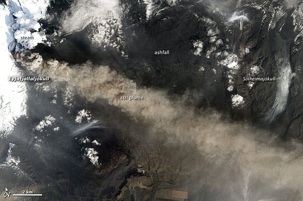
quote:Volcano still shows signs of increasing activity
Iceland's erupting volcano has showed signs of increased activity, but the cloud of ash which wreaked havoc on European air travel is blowing clear of busy flight paths, a panel of scientists said on Thursday.
High altitude winds were pushing the ash cloud directly south over the north Atlantic at a height of about nine kilometers with little impact on flight patterns in northern Europe, except in parts of Ireland, the scientists said.
"The effect on European air traffic should be negligible but that, of course, is up to aviation authorities in each country," meteorologist Gudrun Nina Peterson told a news conference.
The ash cloud rising from the Eyjafjallajokull volcano, located beneath a glacier in southern Iceland, disrupted air travel over northern Europe for a week last month, robbing cash-starved airlines of billions of euros in revenue.
The cloud had shot up as high as 10 kilometers into the air on Tuesday, higher than during the crisis last month, before subsiding somewhat on Wednesday, Peterson said.
Experts said they had picked up signs of increasing seismic activity deep under the volcano which indicated that magma was forcing its way up through layers of rock and approaching the volcanic crust.
"The eruption is going at full speed," said geophysicist Sigurlaug Hjaltadottir. "This is evident by our measurements and by the fact that there is still quite a bit of ash production in the volcano, coupled with massive explosions."
So far the eruption has produced little lava and large amounts of ash -- the result of a fragmentation process by which magma breaks down on its way to the surface under pressure of expanding gases to form tiny, abrasive particles.
If absorbed into the engines of an airplane, the ash particles can cause serious damage.
Hjaltadottir added that ash was still falling over the sparsely populated farm land around the volcano, some 120 kilometers southeast of Reykjavik, but at a far lower rate than at the start of the eruption.
Earlier on Thursday, Ireland lifted all restrictions on its airports on Thursday after a volcanic ash cloud blew away from Europe after having disrupted flights for days.
http://eldgos.mila.is/eyjafjallajokull-fra-fimmvorduhalsi/
2 cams, is die onderste nightview?
thermische camera!
[ Bericht 8% gewijzigd door MarMar op 06-05-2010 21:16:40 ]
2 cams, is die onderste nightview?
thermische camera!
[ Bericht 8% gewijzigd door MarMar op 06-05-2010 21:16:40 ]