WKN Weer, Klimaat en Natuurrampen
Lees alles over het onstuimige weer op onze planeet, volg orkanen en tornado's, zie hoe vulkanen uitbarsten en hoe Moeder Aarde beeft bij een aardbeving. Alles over de verwoestende kracht van onze planeet en tal van andere natuurverschijnselen.


Zou wel wat zijn dat de restanten van de eerste storm in de pacific uitgroeien tot de eerste storm in de Atlantische Oceaan.
Wel Wind Shear in de Golf.
Wel Wind Shear in de Golf.


dan zou Agatha Alex gaan heten...quote:Op dinsdag 1 juni 2010 18:47 schreef aloa het volgende:
Zou wel wat zijn dat de restanten van de eerste storm in de pacific uitgroeien tot de eerste storm in de Atlantische Oceaan.
Wel Wind Shear in de Golf.
[ afbeelding ]


180 doden
quote:Agatha deaths rise to 180 in Central America
By JUAN CARLOS LLORCA (AP) – 5 hours ago
GUATEMALA CITY — Villagers used hoes and pick axes on Tuesday to hunt for victims of landslides that have killed at least 180 people in Central America while officials in Guatemala's capital tried to cope with a vast sinkhole that swallowed a clothing factory.
Thousands remained homeless and dozens still missing following the season's first tropical storm. Rescue crews struggled to reach isolated communities to distribute food and water.
"This is a total tragedy," said Jose Vicente Samayoa, president of a neighborhood group in Amatitlan, a flooded town south of Guatemala's capital.
Officials in Guatemala reported 152 dead but said 100 people were still missing. In the department of Chimaltenango — a province west of Guatemala City — landslides buried rural Indian communities and killed at least 60 people.
Curious onlookers also gathered at a massive and almost perfectly circular sinkhole that swallowed an entire intersection in Guatemala City over the weekend, gulping down a clothing factory but causing no deaths or injuries.
Authorities estimate the hole is 66 feet (20 meters) wide and nearly 100 feet (30 meters) deep, but they are still investigating what caused it.
Nearly 125,000 people were evacuated in Guatemala and thousands more fled their homes in neighboring Honduras, where officials raised the death toll rose to 18 late Tuesday.
Most schools also resumed classes on Tuesday in Honduras.
In El Salvador, 11,000 people were evacuated. The death toll rose to 10 and two others were missing, President Mauricio Funes said Monday night.
About 95 percent of the country's roads were affected by landslides, but most remained open, Transportation Minister Gerson Martinez said. He said 179 bridges had been wrecked.
Agatha made landfall near the Guatemala-Mexico border on Saturday with tropical storm winds of up to 45 mph (75 kph). It dissipated the following day over the mountains of western Guatemala.
The rising death toll is reminding nervous residents of Hurricane Mitch, which hovered over Central America for days in 1998, causing flooding and mudslides that killed nearly 11,000 people and left more than 8,000 missing and unaccounted for.
Bah wat veel. En het seizoen is nu pas echt begonnen.....quote:Op woensdag 2 juni 2010 10:23 schreef aloa het volgende:
180 doden
be nice or go away
Oman krijgt de voltreffer.  Ik heb er ook een apart topic voor geopend.
Orkaan Phet richting Pakistan/India
Orkaan Phet richting Pakistan/India
Ben benieuwd wanneer het in de Atlantische Oceaan gaat beginnen...
Pakistan heeft geluk dat Phet is afgezwakt.
Pakistan heeft geluk dat Phet is afgezwakt.
's Avonds een man, overdags rustig an
Ik ben gisteren aangekomen in Veracruz, golf van Mexico. Hier (nog) geen last van de olie, maar men maakt zich wel grote zorgen.
En in Guatemala is de toestand dramatisch. Mijn distributeur daar vertelde me eergisteren, toen ik eindelijk telefonisch contact met hem kon krijgen, dat het halve land in puin lag. Wel jammer, want ik had er een unit kunnen verkopen, maar de overheid heeft besloten dat de komende maanden al het geld naar de wederopbouw van de infrastructuur gaat. Dus mijn project wordt een paar maanden opgeschoven.
Ik vrees dat het dit jaar wel goed los gaat met orkanen in de Atlantic, hoewel ik het niet hoop natuurlijk
Was het maar waar.quote:Op dinsdag 8 juni 2010 17:59 schreef kahaarin het volgende:
Olielek Golf van Mexico bijna onder controle
Hopelijk lukt het nu dan, iig 1 zorg minder.
Volgens mij stroomt er meer olie uit dan eerder het geval was.
De olieramp en het lek van BP - deel 4.
http://edition.cnn.com/video/flashLive/live.html?stream=stream3&hpt=T1
[ Bericht 9% gewijzigd door #ANONIEM op 08-06-2010 18:13:17 ]
Als je naar de webcam kijkt, lijkt dit bericht niet te kloppen, waarschijnlijk lekt er veel meer uit dan men dacht.quote:Op dinsdag 8 juni 2010 17:59 schreef kahaarin het volgende:
Olielek Golf van Mexico bijna onder controle
Hopelijk lukt het nu dan, iig 1 zorg minder.
Zit wat tropisch geneuzel bij de Windwards (Martinique tot kust Venezuela zeg maar) maar zeer lage kans op ontwikkeling. Het blijft even wachten op onze eerste 'storm'
Weer een Tropische storm op komst boven de Arabische Zee (indische Oceaan).
Dat kan de derde worden in korte tijd.
[ Bericht 1% gewijzigd door #ANONIEM op 10-06-2010 22:03:08 ]
Dat kan de derde worden in korte tijd.

quote:In the midst of cleaning up after Tropical Cyclone Phet, Oman and Pakistan could be in the line of fire as another tropical system begins to develop.
According to AccuWeather.com meteorologists, models continue to suggest a tropical cyclone will develop in the Arabian Sea this weekend.
Heavy rain will continue across southwestern India over the next few days. Rainfall of 2-4 inches can be expected through the end of the day on Friday.
Meteorologists foresee this system moving off the shore over the open water of the Arabian Sea on Saturday.
This most recent tropical development could be the fourth named system of the tropical season in the Indian Ocean.
Tropical Cyclone Phet made landfall over Oman, northwest India and southern Pakistan last week, causing several deaths and many injuries and resulted in thousands becoming displaced after flooding and mudslides.
The National Aeronautics and Space Administration (NASA) provided rainfall estimates of Tropical Cyclone Phet from its Tropical Rainfall Measuring Mission satellite (TRMM) between May 31 and June 6.
TRMM reported rainfall totals of 23.6 inches as Phet traveled over the Arabian Sea. The highest reported totals out of northeastern Oman reached 17.7 inches and between 5.9 and 11.8 inches in Pakistan as Phet made landfall.
Tropical cyclones in the Indian Ocean and South Pacific are the equivalent to the naming of tropical systems as hurricanes in the Atlantic, and typhoons in the Western Pacific.
[ Bericht 1% gewijzigd door #ANONIEM op 10-06-2010 22:03:08 ]


Het water waar dit systeem nu zit is hoger dan vorig jaar September
[ Bericht 0% gewijzigd door #ANONIEM op 13-06-2010 19:43:27 ]
quote:Climatology argues against development of 92L, since only one named storm has ever formed between Africa and the Lesser Antilles Islands in the month of June--Tropical Storm Ana of 1979 (Figure 2). However, sea surface temperatures (SSTs) underneath 92L are an extremely high 28 - 30°C, which is warmer than the temperatures reached during the peak of hurricane season last year, in August - September. In fact, with summer not even here, and three more months of heating remaining until we reach peak SSTs in the Atlantic, ocean temperatures across the entire Caribbean and waters between Africa and the Lesser Antilles are about the same as they were during the peak week for water temperatures in 2009 (mid-September.) While 92L will cross over a 1°C cooler patch of water on Monday, the storm will encounter very warm SSTs of 28-29°C again by Tuesday.
[ Bericht 0% gewijzigd door #ANONIEM op 13-06-2010 19:43:27 ]
Ligt aan de koers die het gaat volgen.quote:Op zondag 13 juni 2010 13:05 schreef SoldMayor het volgende:
Ziet er goed ik denk eerst storm van het jaar
En kan btw meteen een sterke worden
De koers moet dan zuidelijk blijven. De windshear is naar het noorden toe hoger dan in het zuiden.
quote:The forecast for 92L
A major issue for 92L, like it is for most June disturbances, is wind shear. The subtropical jet stream has a branch flowing through the Caribbean and tropical Atlantic north of 10° N that is bringing 20 - 40 knots of wind shear to the region. Our disturbance is currently located at 7°N, well south of this band of high shear, and is only experiencing 5 - 15 knots of shear. This moderate amount of shear should allow for some steady development of 92L over the next few days as it tracks west-northwest at 10 - 15 mph. The National Hurricane Center is giving 92L a medium (30% chance) of developing into a tropical depression by Tuesday morning. Based on visible satellite imagery over the past few hours, I believe this forecast is not aggressive enough, and that 92L has a 50% chance of developing into a tropical depression by Tuesday morning. Another factor holding 92L back is its proximity to the Equator. I would give 92L higher chances of developing if it were not so close to the Equator. The system is organizing at about 7°N latitude, which is so close to the Equator that it cannot leverage the Earth's spin much to help it get spinning. It is quite unusual for a tropical depression to form south of 8°N latitude.
The farther south 92L stays, the better chance it has at survival. With the system's steady west-northwest movement this week, 92L should begin encountering hostile wind shear in excess of 30 knots by Thursday, which should be able to greatly weaken or entirely destroy the storm before it gets to the Lesser Antilles Islands. However, residents of the islands--particularly the northern Lesser Antilles--should follow the progress of 92L closely, and anticipate heavy rains and high winds moving through the islands by Saturday or Sunday next weekend. The GFDL and HWRF models are predicting that 92L will develop into a moderate strength tropical storm that will then be weakened or destroyed by the end of the week, before it reaches the islands. This looks like a reasonable forecast.
volgens andere sites 30 tot 40% kans... en idd watertemperatuur zegt niet alles... kan zijn dat Alex toch nog even op zich laat wachten
Waarschijnlijk gaat het Tropische storm Alex worden.quote:Op zondag 13 juni 2010 22:04 schreef Frutsel het volgende:
volgens andere sites 30 tot 40% kans... en idd watertemperatuur zegt niet alles... kan zijn dat Alex toch nog even op zich laat wachten
Afwachten maar..
Inmiddels is de kans op een Tropische storm opgehoogd naar 60%
quote:1. A LARGE LOW PRESSURE SYSTEM LOCATED ABOUT 1025 MILES WEST-SOUTHWEST
OF THE CAPE VERDE ISLANDS HAS CHANGED LITTLE DURING THE PAST SEVERAL
HOURS. HOWEVER...ENVIRONMENTAL CONDITIONS ARE EXPECTED TO REMAIN
CONDUCIVE FOR ADDITIONAL DEVELOPMENT OF THIS DISTURBANCE AS IT
MOVES WEST-NORTHWESTWARD TO NORTHWESTWARD AT ABOUT 15 MPH. THERE
REMAINS A HIGH CHANCE...60 PERCENT...OF THIS SYSTEM BECOMING A
TROPICAL CYCLONE DURING THE NEXT 48 HOURS.
Alles is gunstig voor ontwikkeling maar het gebeurd (nog) nietquote:There has been an increase in convection or thunderstorm activity with 92L over night. Deep tropical thunderstorms are what drive the heat engine of tropical cyclones. Without convection and upward motion in the atmosphere, the chain reaction cycle cannot be sustained. It will be important now to see if the convection persists or if it comes in bursts. Persistent convection will indicate a steadily strengthening system while bursting indicates one that is struggling.
All of the factors that lead to additional development seem to be in place and thus the NHC is indicating a 60% chance that this will go on to become at least a tropical depression over the next 48 hours. In fact, sea surface temps along the path of 92L are running about two degrees F above normal and are only getting warmer. Upper level winds are favorable in the region as a large area of upper level high pressure builds out over the eastern Atlantic. This acts to shield tropical systems from strong winds high in the atmosphere, giving them room to grow and strengthen. What is odd, however, is the lack of development shown in computer models such as the GFS, ECMWF or UKMET. These are typically reliable models for picking up on the birth of tropical cyclones (tropical cyclogenesis) but are notably reluctant to develop 92L very much. I am very interested to see what happens- whether or not these models are that good and nothing much happens with this system or if it in fact goes on to become a tropical storm, how the models missed it. As I said, there are no obvious reasons for this not to develop but it is extremely early in the season for us to be talking about central Atlantic, deep tropical development
Kans dat het nog wat wordt is gedaald naar 40 %
quote:SHOWERS AND THUNDERSTORMS ASSOCIATED WITH AN AREA OF LOW PRESSURE
LOCATED ABOUT 1375 MILES EAST OF THE WINDWARD ISLANDS HAVE BECOME
LESS ORGANIZED TODAY. ENVIRONMENTAL CONDITIONS ARE MARGINALLY
CONDUCIVE FOR DEVELOPMENT...BUT ARE EXPECTED TO BECOME LESS
FAVORABLE IN A DAY OR TWO. THERE IS A MEDIUM CHANCE...40
PERCENT...OF THIS SYSTEM BECOMING A TROPICAL CYCLONE DURING THE 48
HOURS AS IT MOVES WEST-NORTHWESTWARD TO NORTHWESTWARD AT ABOUT 15
MPH.
Dat onweerscomplex daarachter lijkt er ook wel veelbelovend uit te zien:

's Avonds een man, overdags rustig an
Deze lost denk ik helemaal op dus wachten op de volgendequote:Op maandag 14 juni 2010 22:38 schreef Burnie88 het volgende:
Dat onweerscomplex daarachter lijkt er ook wel veelbelovend uit te zien:
[ afbeelding ]
quote:GLOBAL MODELS CORRECT THIS TIME AROUND
There was apparently a reason why the global models did not show 92L developing in to anything significant. The reason being that, in fact, it looks like the system will not develop much over the coming days. As impressive as it appeared on satellite imagery, it's just too early in the season to look for east Atlantic tropical cyclone formation. Upper level winds are still just too strong and other subtle environmental conditions are not in place. However, the tropical wave has an obvious well defined low pressure center associated with it and the entire mass of energy will move off to the west to west-northwest over the next several days. We'll have to wait and see if more conducive conditions await farther west, perhaps in the western Caribbean Sea. The very fact that this system looked (and still does to some extent) so well organized for this time of year is important because it signifies a change in the deep tropics over last season. Instead of dry, stable, sinking air, which was the rule for most of last year, we are seeing a much more favorable pattern of lower pressures, higher sea surface temps and overall upward motion in the atmosphere. Once we get closer to August, I believe things will become very active and remain so through the rest of the season. 92L is a warning shot for us to take notice that the season could be very serious. For now, we are doing okay in that no significant development is expected with this feature, or elsewhere, for the next few days at least.


LOL  Bizar plaatje idd
quote:DEVELOPMENT POTENTIAL ON THE INCREASE THIS WEEK
It looks as though the quiet start to the season could come to an end soon. The ECMWF model, one of the more reliable global computer models, has been indicating the possibility of tropical cyclone formation in the Caribbean Sea for the past few days. Other models are also suggesting this but none seem to be as bullish as the ECMWF. The trigger would appear to be a tropical wave moving through the eastern Caribbean Sea now which has been labeled by the NHC as having a low chance of development over the next 48 hours. Beyond that time, perhaps four days from now, it should reach the western Caribbean and show signs of organization as an upper level high pressure area builds in across the region. This would provide the shelter needed from relentless strong winds aloft and allow for development. I am going to outline all of this on today's Weekly Hurricane Outlook video which will be broadcast live at 11am ET right here on the homepage. I will go over several of the models, including the ECMWF, to show what they are suggesting will happen. The bottom line is that it appears the pattern is going to change and allow for the potential for the first named storm of the season to develop over the coming week.

quote:A LARGE AREA OF SHOWERS AND THUNDERSTORMS OVER THE EASTERN CARIBBEAN
SEA IS ASSOCIATED WITH A STRONG TROPICAL WAVE THAT IS MOVING
WESTWARD AT 10 TO 15 MPH. ALTHOUGH THERE IS NO EVIDENCE OF A
SURFACE CIRCULATION...THIS SYSTEM IS SHOWING SOME SIGNS OF
ORGANIZATION AND ENVIRONMENTAL CONDITIONS APPEAR CONDUCIVE FOR
GRADUAL DEVELOPMENT DURING THE NEXT COUPLE OF DAYS. THIS WAVE
COULD PRODUCE LOCALLY HEAVY RAINFALL AND GUSTY WINDS OVER PORTIONS
OF NORTHERN VENEZUELA...THE NETHERLANDS ANTILLES...PUERTO
RICO...THE DOMINICAN REPUBLIC...AND HAITI OVER THE NEXT DAY OR SO.
THERE IS A MEDIUM CHANCE...30 PERCENT...OF THIS SYSTEM BECOMING A
TROPICAL CYCLONE DURING THE NEXT 48 HOURS.
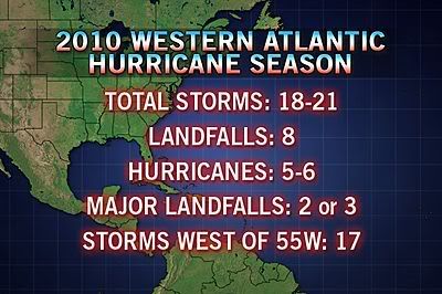
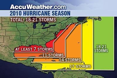
Even More Hurricanes Expected this Season, Three Could Hit Oil Spill
[ Bericht 1% gewijzigd door #ANONIEM op 21-06-2010 22:59:23 ]
quote:The 2010 hurricane season is set to become even more extreme, with 18-21 named storms now in the forecast, and some of those storms will impact the oil spill in the Gulf.
AccuWeather.com Chief Hurricane Meteorologist Joe Bastardi has upped his original forecast from 16-18 storms, to 18-21, with at least eight impacts and six hurricanes, and two or three of those hurricanes will have major landfalls. Only five years in the 160 years of records had 18 or more storms in a season.
"The hurricane season should have several hits on the U.S. coast from July through September, mainly in the Southeast and Gulf," said Bastardi.
Bastardi suggests that based on years with a similarly active hurricane forecast as 2010, at least two hurricanes and one tropical storm are set to move through the area of the Gulf oil spill by the end of the tropical season.
As many as three other tropical systems have the potential to track close enough to the spill to impact cleanup and capping operations, as well as other oil rig operations in the Gulf.
"Above-normal tropical activity should feature four named storms in July, with one or two impacting the coastal areas," said Bastardi.
August will also feature an influx of storms.
"August should have six named storms, with two of three impacts on the U.S. coastline," said Bastardi.
Bastardi predicts the heart of this season's storms will occur between Aug. 15 and Oct. 15.
"Not only will that period be more active than normal, but the run up to it, and the time after it," said Bastardi. "There could be a period where there is a group of naming, two or three going on at once and five in a 15-20 day period."
He is confident that tropical activity will occur before mid-August in the Gulf of Mexico, the estimated time frame at which BP expects the oil leak to be capped.
Back in February, Bastardi based his predictions for the 2010 season on the tropical activity of analog years 1995, 1998, 2005 and 2008.
Most of the past analog years Bastardi considered in his 2010 forecast for the Gulf had tropical activity before the middle of August.
Even later into the summer, hurricane season will continue to ramp up.
"By late August and September, the hurricane season should be front and center," said Bastardi. "Expect eight named storms in September and three or four U.S. impacts."
An extreme winter and now an above-normal hurricane season could place 2010 in the record books.
"It's hard to fathom another 12-month period where such wild swings would make weather so significant for such a large area of the population," said Bastardi.
Hurricane season begins June 1 and ends Nov. 30.

[ Bericht 1% gewijzigd door #ANONIEM op 21-06-2010 22:59:23 ]
Die depressie bij Venezuela en de Bovenwindse eilanden gaat inderdaad Alex worden, hij krijgt zelfs al enigszins de vorm van een hurricane. Er hangt ook nog een sliert bewolking achter dat volgens mij nummer 2 gaat worden. En ik zag dat voor van de Kaapverdische eilanden zich ook e.e.a. ontwikkeld. Kijken wat dat gaat doen. Morgen verlaat ik het Caribische gebied gelukkig weer 
Net nieuwe update gezien, nu 50% kans op tropische storm. En aan de Pacific kant gaat het ook lekker, Celia naar categorie 2 en het systeem erachter 60% kans op ontwikkeling.
quote:9:30PM EDT Update 21 June 2010
The first signs of a low level circulation are beginning to appear, upping chances for development to about 50%. The circulation is roughly around 14.0N 72.0W. Assuming it maintains itself, it may be upgraded to a depression tomorrow, or more likely after recon gets out there on Wednesday.
Models are still a bit too soon to believe, the latest GFDL run appears too far to the north.

quote:6PM EDT Update 21 June 2010
The wave in the Eastern Caribbean Sea (93L) is a rather large system, but currently lacks a low level circulation. Conditions around it support a low chance for tropical development, but if it can hold together the largest chances will be when it reaches the western Caribbean sea later in the week.
Earlier forecast model runs overdid the system. This system has a better chance to develop than last week's 92L, but still the overall odds are against development. The most likely scenario is that it remains a wave or a tropical depression and moves its way into the Yucatan. While the system does not have a low level circulation, models won't be of much use.
Watching the model trends over the week, and signs for more circulation is important. There is a recon flight scheduled out for Wednesday, which is probably the best opportunity for real data and I don't expect it to be upgraded (if it is at all) before that.
Again the June factor along with the Jet are probably the biggest factors against development right now. If it has a circulation when it enters the west Caribbean, then chances go up quite a bit and could actually form into something.
In short watch it closely, but ihe wave known as 93L is most likely to impact Mexico with rain.