WKN Weer, Klimaat en Natuurrampen
Lees alles over het onstuimige weer op onze planeet, volg orkanen en tornado's, zie hoe vulkanen uitbarsten en hoe Moeder Aarde beeft bij een aardbeving. Alles over de verwoestende kracht van onze planeet en tal van andere natuurverschijnselen.


Hehe goedzo, dat was ook precies mijn gedachte. Uiteraard blijven het briljante beelden.quote:Op zondag 9 mei 2010 20:50 schreef Burnie88 het volgende:
Dat wordt weer heftig morgen...
Ik zit nu Tornado Road te kijken. Inderdaad erg amateuristisch Drasss. Ik erger me na een kwartier kijken al aan die kale homo. Beetje wijs lopen doen bovenop een heuvel met heftig veel blikseminslagen om hem heen. En kijk hem eens stoer zijn... Daarentegen wel gave beelden!
Eens kijken of ik de stormen die de poster boven ons postte kan volgen morgen.
"We're in a tornado now"
"We're in a tornado now"
"We're in a tornado now"
"We're in a tornado now"
"We're in a tornado now"
"We're in a tornado now"
"We're in a tornado now"
"We're in a tornado now"
Wat een kneuzen! Ondertussen is iedereen bang om in de kern/rotatie te komen. Dan zie ik toch liever Storm Chasers ja
"We're in a tornado now"
"We're in a tornado now"
"We're in a tornado now"
"We're in a tornado now"
"We're in a tornado now"
"We're in a tornado now"
"We're in a tornado now"
Wat een kneuzen! Ondertussen is iedereen bang om in de kern/rotatie te komen. Dan zie ik toch liever Storm Chasers ja
's Avonds een man, overdags rustig an

De eerste post uit dit topic gaat over dat padvinderskamp, waar ze het over hadden in Tornado Road .
http://www.tornadovideos.(...)ak-possible-tomorrow
Jaja het zal los gaan. Vooral bij OKC en richting Kansas.. Dat gebied ken ik erg goed dus straks maar eens gaa volgen.
Jaja het zal los gaan. Vooral bij OKC en richting Kansas.. Dat gebied ken ik erg goed dus straks maar eens gaa volgen.
Dat wordt wat vandaag.
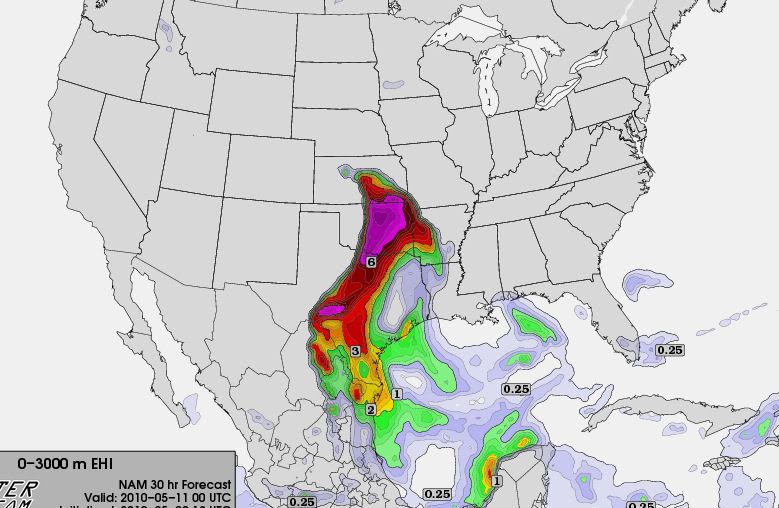
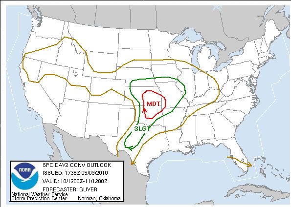
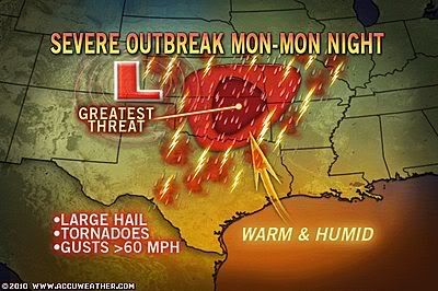
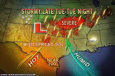
quote:May 10, 2010 could go down as a day storm chasers, weather enthusiasts and residents of the southern Plains remember for a long time. Current data suggests that a significant outbreak of severe weather and tornadoes is likely to occur across parts of Oklahoma and Kansas, and possibly stretching into western Missouri. As such, the Storm Prediction Center has issued a Day-2 Moderate risk, which is very likely to be upgraded to High Risk for tomorrow.
Intense thunderstorms are expected to develop along and just east of a dryline that will enter western Oklahoma during the afternoon. For several days leading up to this event, there was some indication that a strong cap could prevent storms from firing until around dark (or at all), but more recent model runs have shown weaker CIN, as well as precipitation breaking out on the NAM reflectivity model; at this time, it does appear that the cap will break. A very moist, unstable air mass will be in place across the risk area, along with tremendous wind energy. Directional shear will be favorable for strongly rotating supercells, which are likely to be long-lived and would have the potential to produce strong to violent tornadoes. Right now there is a question as to how many storms people should expect. That is hard to predict; there could be 2-3 isolated monster storms all day, or multiple supercells could explode across the region and continue into the evening. Regardless of that, people in the risk area should definitely take some time now to review all critical weather safety information. Be sure you have a plan in place, and pay close attention to watches and warnings. This could easily be the biggest chase day of the year as well, with numerous storm chasers flocking to Oklahoma and Kansas from as far away as Montana, Michigan, Minnesota and even Europe! Vortex2 will also be out. It goes without saying that tomorrow will be a memorable weather day on a variety of levels. Be safe if you're heading out!
Hmm High risk gebied zit momenteel alleen de grote stad Tulsa OK in. Oklahoma City gelukkig net op het randje.
OMG, ze verwachten dus toch wel wat heftigs vandaag. En dat allemaal op zo'n klein gebied... Ben erg benieuwd, ga het zeker volgen vanavond/vannacht.
's Avonds een man, overdags rustig an
Ik heb hem al heel de dag openstaan dus ik zal het ook allemaal gaan volgen.quote:Op maandag 10 mei 2010 19:16 schreef Burnie88 het volgende:
OMG, ze verwachten dus toch wel wat heftigs vandaag. En dat allemaal op zo'n klein gebied... Ben erg benieuwd, ga het zeker volgen vanavond/vannacht.
quote:Op maandag 10 mei 2010 19:29 schreef Drassss het volgende:
[..]
Ik heb hem al heel de dag openstaan dus ik zal het ook allemaal gaan volgen.
Tornadovideos.net?
quote:Tracking High-Wind Warning in Woodward OK
Wat houdt dat in ? Possible tornado bij Woodward?quote:High Wind warning means an Hazardous High Wind Event is Expected or Occuring
Klopt, maar internet is nogal zwak hier. Dus ik ga even opzoek naar mijn oude vertrouwde sites die ik gebruikte toen ik daar ook wasquote:Op maandag 10 mei 2010 19:33 schreef Frutsel het volgende:
[..]Wat heb je precies open staan?
Tornadovideos.net?
Thx
Sorry, had je al gepm'ed
ik zit naar die trackingdingetjes te kijken, maar das nou niet echt spectaculair
Sorry, had je al gepm'ed
ik zit naar die trackingdingetjes te kijken, maar das nou niet echt spectaculair
Hehe het is nog vroeg daar he. 12.49 ongeveer dus het moet allemaal nog op gang komen.
Die high wind is volgens mij gewoon een windwaarschuwing. Dus windstoten.
http://www.srh.noaa.gov/oun/
Wel een goede site voor alle warning/watches, Hierop kan je ook je wind warning zien in Woodward.
Die high wind is volgens mij gewoon een windwaarschuwing. Dus windstoten.
http://www.srh.noaa.gov/oun/
Wel een goede site voor alle warning/watches, Hierop kan je ook je wind warning zien in Woodward.
Morgen en woensdag worden ook weer zware buien verwacht.
In zo'n beetje hetzelfde gebied.
De extreem warning is voor vandaag. Noaa heeft inmiddels een tornado watch uitgegeven.
In zo'n beetje hetzelfde gebied.
De extreem warning is voor vandaag. Noaa heeft inmiddels een tornado watch uitgegeven.
http://www.intellicast.co(...)px?location=USOK0400
Deze site geeft altijd goed weer waar de stormen zich precies bevinden.
Edit: Watch momenteel West-Kansas
Deze site geeft altijd goed weer waar de stormen zich precies bevinden.
Edit: Watch momenteel West-Kansas
Ik post lekker door 
Er onstaat nu een lijn met nieuwe cellen op het grens gebied van Oklahoma/Kansas. Deze gaan richting het gebied met de 30% kans op tornado's in Oklahoma ( Tulsa ).
Er onstaat nu een lijn met nieuwe cellen op het grens gebied van Oklahoma/Kansas. Deze gaan richting het gebied met de 30% kans op tornado's in Oklahoma ( Tulsa ).
Jep Fruts. In Oklahoma heb je een shitload aan chasers en die gaan nu uiteraard Allemaal! op pad hehe.
Ik zou zeggen dat het over een uurtje of 2 los zal gaan in Oklahoma...
Ik zou zeggen dat het over een uurtje of 2 los zal gaan in Oklahoma...
Er ontstaan inderdaad superieurecellen momenteel. Hopelijk wordt het geen buienlijn, daar heeft niemand wat aan. Gewoon losse cellen is het beste. Een gigantische wallcloud zou wel vette beelden opleveren
's Avonds een man, overdags rustig an
Die cell bij Dodge City is wel een monster zeg.
Alle chasers zitten net ten noorden van OKC, dus dat lijkt me het gebied waar het los zal gaan.
Alle chasers zitten net ten noorden van OKC, dus dat lijkt me het gebied waar het los zal gaan.
Je moet even in het kaartje bij "weather" Warning aanklikken. Dan krijg je counties in het kaartje en waar momenteel warnings zijn.
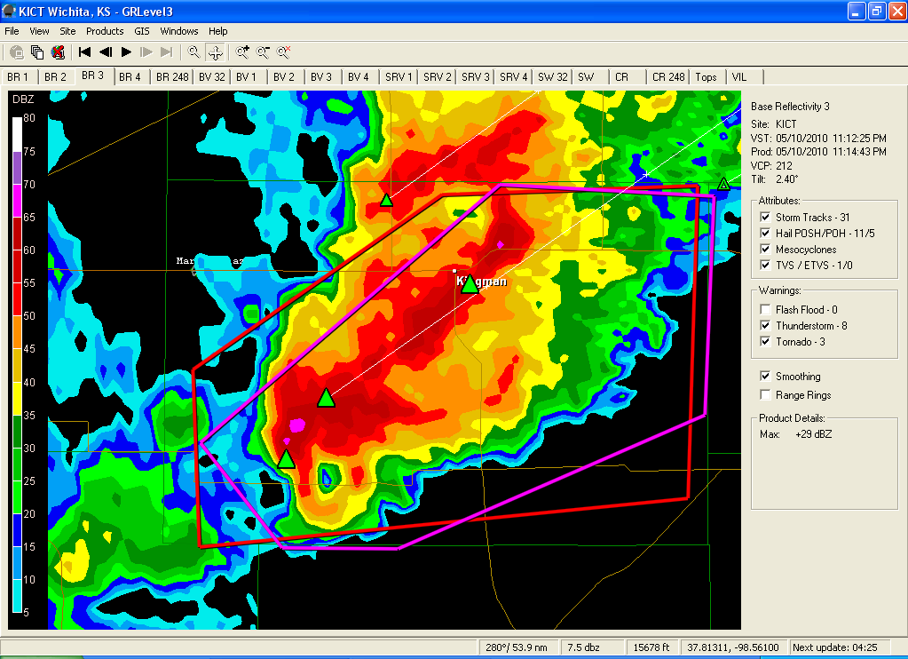
In Kansas momenteel 4 counties met een tornado warning. Tevens is er bij Greensburg ( paar jaar terug die F5) een cell aan het ontwikkelen. Daar zit nu een chasers midden in..
In Kansas momenteel 4 counties met een tornado warning. Tevens is er bij Greensburg ( paar jaar terug die F5) een cell aan het ontwikkelen. Daar zit nu een chasers midden in..
Hop 2 min na men bericht meteen Tornado warning erop.quote:Op maandag 10 mei 2010 21:23 schreef Drassss het volgende:
Grote cell nu oost van Woodward die naar het oosten gaat. Dat kan wel eens een goede worden.
Gaat dus om de cel Oost van Woodward die noordoost gaat richting de grens van Kansas.
Tja de cell is Woodward al voorbij dus eigenlijk 1tje verder al. Tevens nu thunderstorm in het noorden oost van Dodge City.quote:
Klopt die beelden lopen niet echt lekker.
Die cell nu noord-west van Greensburg heeft nu ook een tornado warning...
Die cell nu noord-west van Greensburg heeft nu ook een tornado warning...

Zit iedereen in NL te kijken ofzo? 
Vi är Borg. Motstånd är meningslöst. Ni kommer att bli assimilerade!!
Weer een nieuwe cell aan het vormen. Deze is onder Woodward en gaat net ten noorden van Oklahoma City trekken ( gelukkig maar ).
Kloptquote:Op maandag 10 mei 2010 21:48 schreef Frutsel het volgende:
De tornadowarning bij Greensburg zie ik nog niet op het kaartje
Cell bij Woodward lijkt me nu het boeiendste.
Tornado aan het vormen oost van Woodward. Als je op de livecam van Wes Luginbyhl gaat kan je hem zien!
Cel daar boven lijkt een goede te worden. Hopelijk verliezen ze niet hun kracht doordat ze dicht bij elkaar liggen.
WTF hee, de supercells ontwikkelen zich in rap tempo nu. Reed Timmer zit nu bij een vette supercel en er lijkt zich een haak te vormen in de bui. Dat kon nog wel eens een grote tornado gaan vormen.
Eerst maar eens even douchen en dan straks weer kijken
Eerst maar eens even douchen en dan straks weer kijken
's Avonds een man, overdags rustig an
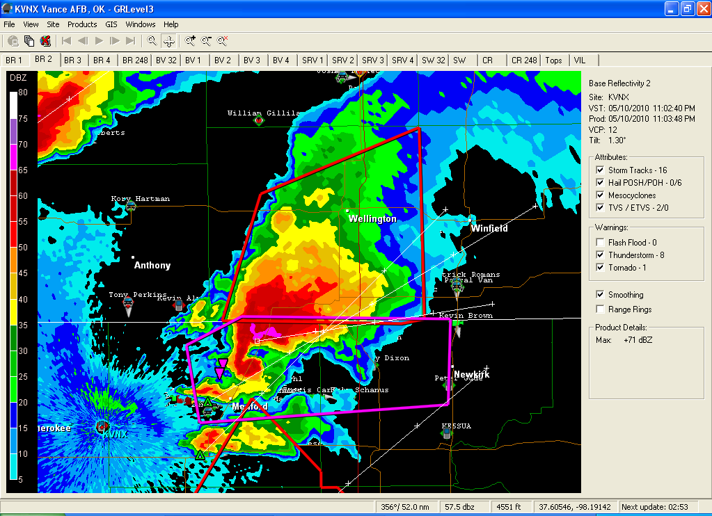
Hmmz vrees dat een tornado het stadje Cherokee in Oklahoma heeft geraakt. Hij is nu noordoost aan het gaan richting de grens van Kansas. Met de radar zie ik wel iets van een haak wat op een flinke tornado kan duiden...
Arkansas City zit ook gevaarlijk... Zat gisteren nog te kijken naar een report over Greensburg EF5, alles duidt erop dat zo'n ramp er vandaag weer in zit... Gigantische supercellen en superveel CAPE, vocht en temperatuurverschillen.
's Avonds een man, overdags rustig an
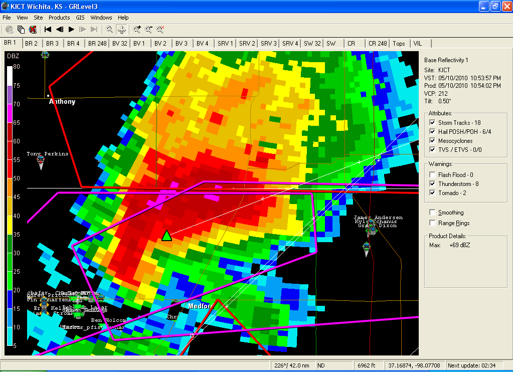
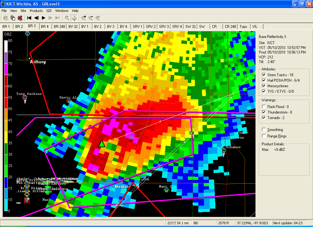
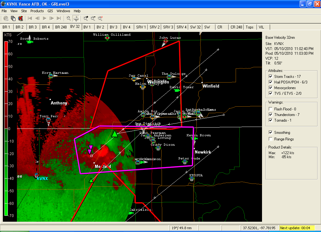
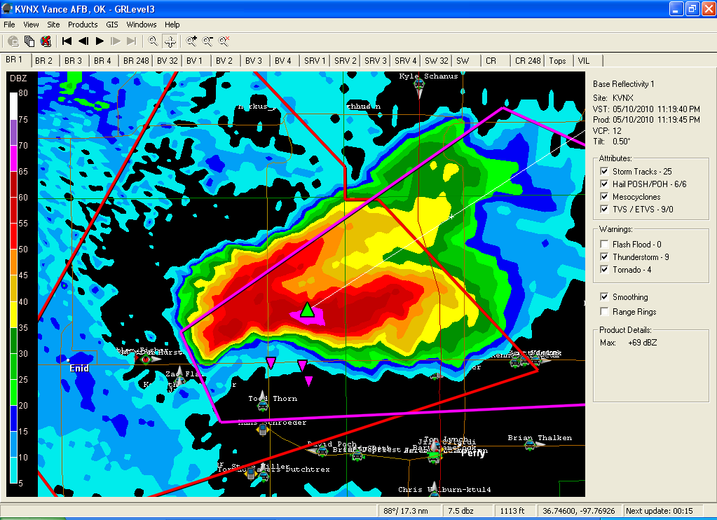
Die supercel tussen Arkansas City en Medicine Lodge moet wel een tornado bevatten. Wat een haak zit daar aan zeg!
's Avonds een man, overdags rustig an
Ja dat is echt een ziekelijke cell. Al lijkt de cell eronder toch nog enormer. Alle chasers zitten er pal zuid van waar je ook een enorme haak ziet. Dat ding gaat vol richting een klein dorpje, Wakita momenteel.quote:Op maandag 10 mei 2010 22:42 schreef Burnie88 het volgende:
Die supercel tussen Arkansas City en Medicine Lodge moet wel een tornado bevatten. Wat een haak zit daar aan zeg!
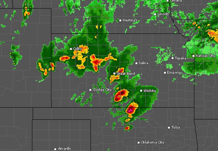

Wakita en Renfrow kunnen wel een tornado verwachten denk ik... Alles zit er op en er aan:
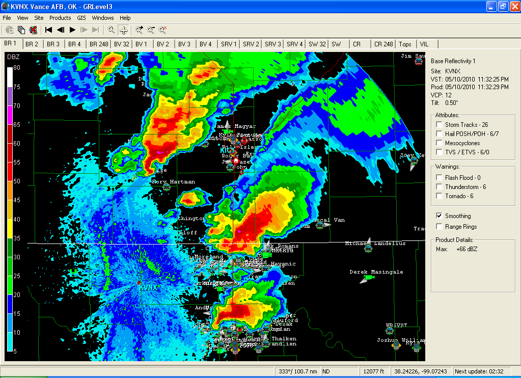
Flinke circulatie (de groen en rode punt: rood: neerslag nadert de radar / groen: gaat van radar weg)
WER (weak echo region) (gebied op hoogte met weinig neerslag door de sterke stijgstroom)
Flinke circulatie (de groen en rode punt: rood: neerslag nadert de radar / groen: gaat van radar weg)
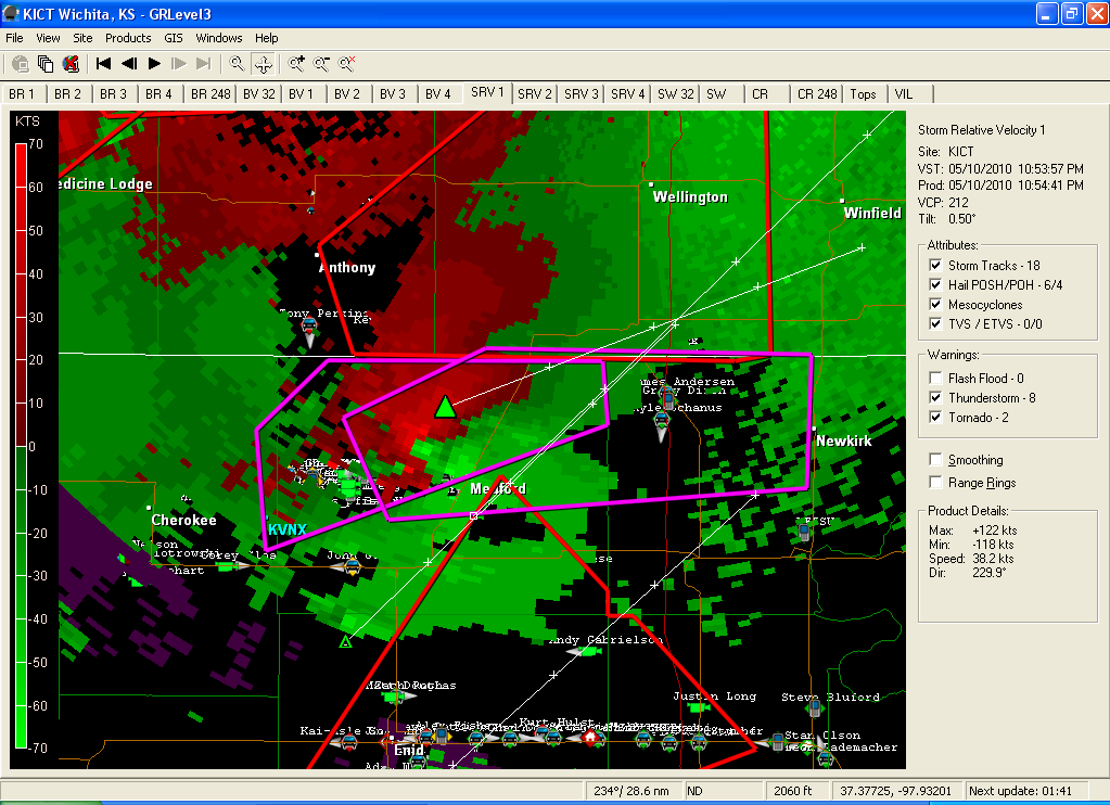
WER (weak echo region) (gebied op hoogte met weinig neerslag door de sterke stijgstroom)
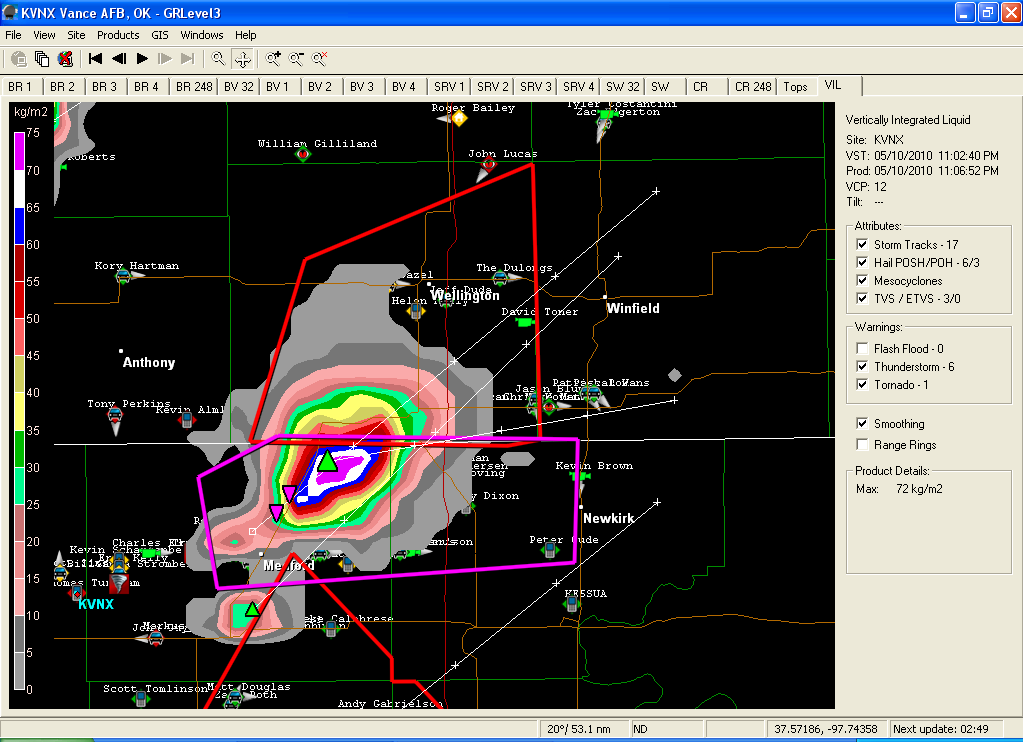
Inmiddels 6 tornado's confirmed en het feest gaat nog beginnen.
's Avonds een man, overdags rustig an
Ten zuiden van die monstersupercell ontstaat ook iets flinks...
's Avonds een man, overdags rustig an
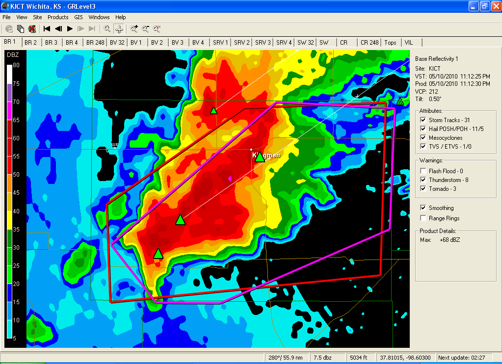
Tevens stevenen er nu 2 ontwikkelende supercells op OKC af...
http://radar.weather.gov/radar.php?rid=TLX&product=NCR&overlay=11101111&loop=yes
http://radar.weather.gov/radar.php?rid=TLX&product=NCR&overlay=11101111&loop=yes
's Avonds een man, overdags rustig an
Ja, klopt. Die zal binnen niet te lange tijd ook wel tornadowarned worden. Mist alleen nog een haak. Die andere bui blijft echt heerlijk:quote:Op maandag 10 mei 2010 23:09 schreef Burnie88 het volgende:
Ten zuiden van die monstersupercell ontstaat ook iets flinks...
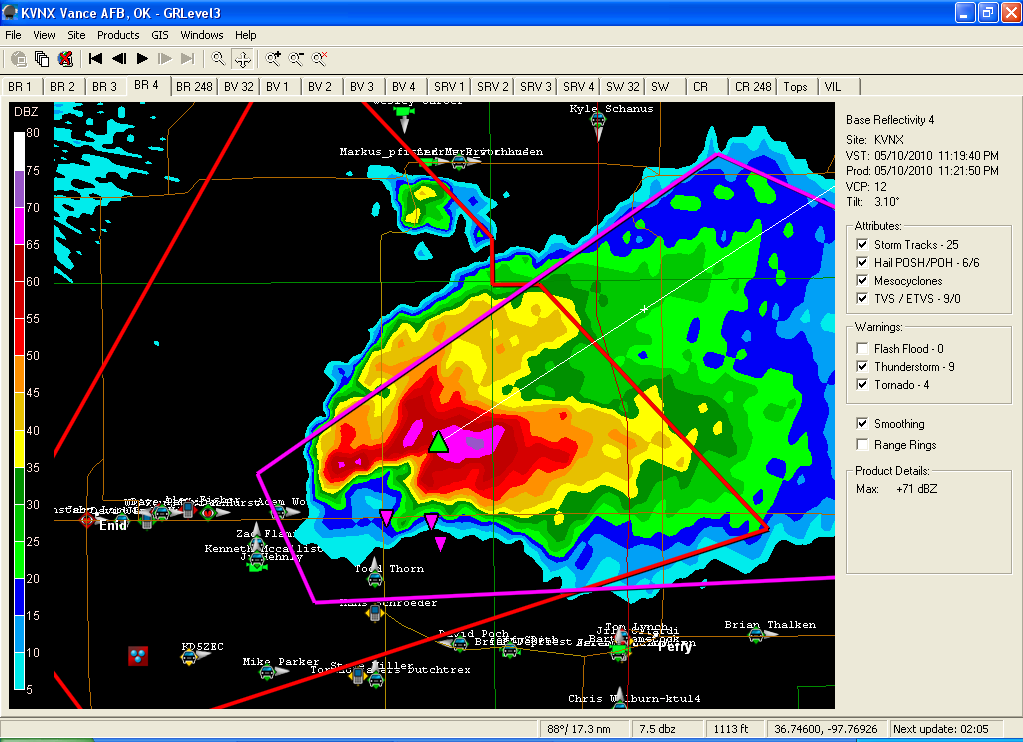
Haak
Circulatie
De cel zit vol neerslag
Wat een fantastische afbeeldingen i2. Dat programma is zeker niet gratis?
Die monstercel gaat dus recht op Arkansas City af...
Die monstercel gaat dus recht op Arkansas City af...
's Avonds een man, overdags rustig an
Officieel niet gratis, maar er gaat wel een torrent rond. Dan is het wel gratis. Is de moeite. Het programma heet: GRLevel3 Weather Radar. Je kan het volgens mij ook 15 dagen gratis proberen. Als je het programma hebt is deze site aan te raden: http://www.supercell.nl/grlevel3.html . Helpt je een beetje op pad.
Nu zijn al de 3 cellen tornado warned. Was te verwachten!
Nu zijn al de 3 cellen tornado warned. Was te verwachten!
Thnx!
Arkansas City is very fucked. De haak gaat recht op het centrum af. Kan niet goed gaan gewoon.
Arkansas City is very fucked. De haak gaat recht op het centrum af. Kan niet goed gaan gewoon.
's Avonds een man, overdags rustig an
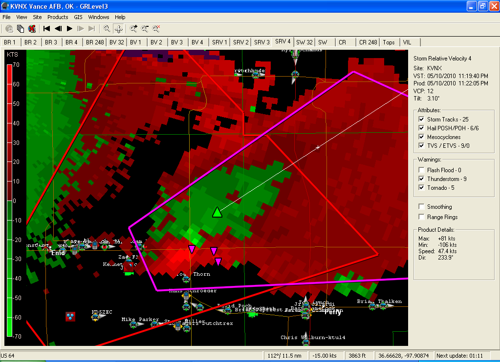
Die cel daaronder vormt nu ook een hele mooi haak. Goed te zien: http://radar.weather.gov/radar.php?rid=vnx&product=N0R&loop=yes
Met linkermuisknop inzoomen
Met linkermuisknop inzoomen
's Avonds een man, overdags rustig an
En het is daar gewoon overdag? Ja dus, en dan zo donkerquote:Op maandag 10 mei 2010 23:23 schreef aloa het volgende:
deze rijd dus bij die bui bij arkansas city
http://www.chasertv.com/a(...)197_steve-polley.php
's Avonds een man, overdags rustig an
Medicine Lodge ook een tornado lijkt me. Mooie haak gevormd. Zo kut dat ik weer vroeg uit bed moet morgen...
's Avonds een man, overdags rustig an
Klopt. Een hele vette is daar aan het ontwikkelen.
OK noteert de eerste 'significante schade', geen verdere informatie bekend. Kan niet goed zijn.
Nog veel plezier vanavond mannen, ik ga me bed opzoeken!
OK noteert de eerste 'significante schade', geen verdere informatie bekend. Kan niet goed zijn.
Nog veel plezier vanavond mannen, ik ga me bed opzoeken!
's Avonds een man, overdags rustig an
Heel hard aan het ontwikkelen. Is op het moment al een supercell.quote:Op maandag 10 mei 2010 23:31 schreef Burnie88 het volgende:
Klopt. Een hele vette is daar aan het ontwikkelen.
OK noteert de eerste 'significante schade', geen verdere informatie bekend. Kan niet goed zijn.
Nog veel plezier vanavond mannen, ik ga me bed opzoeken!
Komt goed hier

Waren zeker 17 tornado's(allen al! ) in de buurt van Oklahoma City een aantal die toch een paar dorpen ( vooral zuid van OKC ) hebben geraakt.
quote:5 doden door tornado's in de VS
OKLAHOMA-STAD (ANP) - Tornado's hebben maandag een eind gemaakt aan zeker vijf mensenlevens in de staat Oklahoma. Tientallen mensen werden met botbreuken en hoofdwonden opgenomen in ziekenhuizen, meldde CNN. Een aantal van hen verkeert in kritieke toestand.
Alleen in en rond Oklahoma-Stad, de hoofdstad van de centraal gelegen staat, kwamen al 35.000 mensen zonder stroom te zitten als gevolg van het natuurgeweld. Diverse wijken en voorsteden zijn zwaar getroffen door de tornado's. Huizen raakten zwaar beschadigd, bomen en elektriciteitsmasten braken en op sommige plaatsen belandden zelfs auto's op daken van woningen.
In de naburige staat Kansas sloegen tornado's eveneens toe. De kracht van de windhozen was hier minder sterk, waardoor de schade meevalt.


Filmpje --> http://video.foxnews.com/v/4187085/funnel-cloud-caught-on-tapequote:NORMAN, Oklahoma -- Tornadoes ripped through Oklahoma on Monday in an outbreak of violent weather that killed five people, tossed cars off highways, flipped mobile homes and sent baseball-size hail crashing through windshields, officials said.
Oklahoma Department of Emergency Management spokesman Jerry Lojka said two people were killed in Oklahoma City and three were killed in Cleveland County, south of the city. Oklahoma City officials said the fatalities there involved a young boy who was hit by debris in his home and a man whose recreational vehicle flipped over on top of him. Details on the Cleveland County deaths weren't immediately available.
Officials reported that at least 58 others suffered injuries throughout Oklahoma in the daylong onslaught. Two of the injuries were critical. In some neighborhoods in Oklahoma City, emergency workers were going door to door to make sure everyone was accounted for.
The storms were part of a violent weather system that also spawned twisters in Kansas and that forecasters had been predicting since last week.
"You could just hear stuff hitting the house," Linda Sugg said, who rode out the storm in her home in Norman, the largest city in Cleveland County. After the weather cleared, she walked through her litter-filled front yard, picking up debris.
Power was out to more than 37,000 homes and businesses statewide.
Many Oklahoma residents had been prepared for the bad weather. TV broadcasters dedicated their entire day to storm coverage, with some showing live video of the twisters as they rolled across the countryside.
"The kids and I got in the closet and prayed," said Jamie Keyes, of Norman, about 20 miles (30 kilometers) south of Oklahoma City. "I heard a hiss. It was like something was whistling very loud," she said. "We're all very fortunate."
Near Seminole, about 60 miles (100 kilometers) east of Oklahoma City, at least two homes were leveled after a tornado went through, Emergency Management Director Ernie Willis said. Emergency responders were going through the area to determine if anyone was hurt or trapped, he said.
Widespread destruction led authorities to close Interstate 40, a major east-west route, in both directions just east of Oklahoma City. Traffic was backed up three miles (five kilometers).
A Love's truck stop took a direct hit.
"Miracle of all miracles, we don't have any injuries from that location," Love's spokeswoman Christina Dukeman said. "We will rebuild and reopen."
Interstate 35, which runs from Mexico to Minnesota, also was closed briefly at the Kansas-Oklahoma border because overturned tractor-trailers blocked all lanes. At Moore, near Oklahoma City, trucks were overturned in the median but the road remained open.
In Kansas, the most serious damage was reported in Belmont. Several homes were damaged in the town east of Topeka and widespread power outages were reported. No injuries were reported.
Hours after hitting Oklahoma, the tornado-producing storm cell was moving into Arkansas.
Oklahoma City and its suburbs saw three storms develop just to the west and each caused damage as they moved across an area home to 1.2 million people.
The northern storm caused property damage near Edmond; two storms to the south turned into killers -- the one fatality near the truck stop and the three at Tecumseh, on the metro area's eastern edge.
"We've had a very strange event: multiple tornadic portions with this event as it came through," said David Barnes, the emergency management director for Oklahoma County. "We have multiple vehicles overturned, a housing addition has had multiple homes destroyed."
Tornado warnings in the Plains states and Midwest had all expired by 11:15 p.m. CDT (0315 GMT).
Jep Fruts ik kreeg het allemaal te horen van mensen die ik ken in de omgeving Edmond (Oklahoma). In 2009 was daar ook al een tornado, maar ook deze keer komen ze daar goed weg. Gister zijn dus wat tornado's dwars door het druk bevolkte gebied van Oklahoma City gegaan..

Gisteren toch weer 4 tornado's geweest. Voorlopig even rustig.
's Avonds een man, overdags rustig an

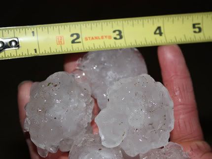
Ongelofelijke hagelbui in OKC momenteel. Hagel groter dan tennisballen... Auto's over de kop etc door iets van een tornado.
Storm cell is nu 1 mega regenvlek op de kaart geworden.
Er komen nu wel nieuwe cellen in het westen van Oklahoma opzetten.
Er komen nu wel nieuwe cellen in het westen van Oklahoma opzetten.
Die moet je niet op je hoofd krijgenquote:Op maandag 17 mei 2010 12:43 schreef Drassss het volgende:
http://www.news9.com/global/story.asp?s=12490042
Veel hagelschade.