WKN Weer, Klimaat en Natuurrampen
Lees alles over het onstuimige weer op onze planeet, volg orkanen en tornado's, zie hoe vulkanen uitbarsten en hoe Moeder Aarde beeft bij een aardbeving. Alles over de verwoestende kracht van onze planeet en tal van andere natuurverschijnselen.


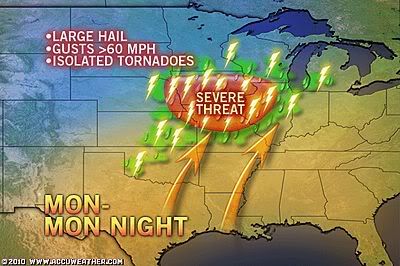
Kans op tornado's
quote:Building warmth and the arrival of more humid air has opened the door for dangerous thunderstorms stretching from the Mississippi Valley to the Atlantic Seaboard this week.
Among the usual risks from the storms, ranging from lightning strikes to blinding downpours, is potential for large hail, damaging wind gusts and even tornadoes in the strongest storms.
Over the four-day period, storms will affect much of the eastern half of the nation.
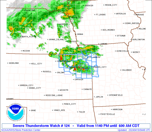
The severe thunderstorm threat into tonight will stretch from eastern Kansas and Nebraska to southern Wisconsin and northern Illinois. Storms will fire along and ahead of a northward-advancing warm front. Kansas City is one of several major metropolitan areas at risk for damaging thunderstorms.
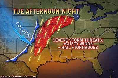
A cold front will be the trigger for nasty thunderstorms Tuesday, Wednesday and Thursday.
The threat Tuesday will stretch from north-central Texas to southern Wisconsin.
During Wednesday, the severe thunderstorm risk area will advance farther to the east, stretching from the upper Texas coast and much of Louisiana to eastern Illinois, much of Indiana, and southern Lower Michigan.
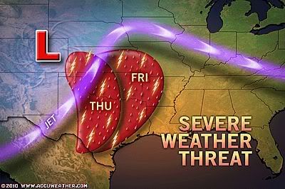
quote:Severe storms are expected to develop from central Kansas to northwestern Texas on Thursday and push east into areas from eastern Kansas to northeastern Texas by Friday. The central and lower Mississippi Valley will be targeted on Saturday and the Tennessee Valley on Saturday night.
These storms will likely produce large and damaging hail, gusty winds and tornadoes. Flooding rain is possible across the lower and mid-Mississippi Valley on Saturday.
Expected Disruptions
Disruptions to travel are expected across the South over the next several days as the severe weather moves through.
Highway travel will be affected most as debris, downed trees and power lines could make driving a nightmare in some spots.
Interstate 40 from Oklahoma City to Nashville could be most affected over the next several days, while all other highways in the region could be prone to delays and detours.
Meanwhile, flights into and out of the region's airports will also face delays as this line of storms moves east.

Het wordt eindelijk spannend de komende dagen. Op SPC staat dat het zaterdag severe gaat worden.
's Avonds een man, overdags rustig an

Ben benieuwd wat het gaat worden. De eerste hagel en tornado meldingen zijn al binnen.quote:Op woensdag 21 april 2010 23:44 schreef Burnie88 het volgende:
Het wordt eindelijk spannend de komende dagen. Op SPC staat dat het zaterdag severe gaat worden.
Men verwacht zwaar onweer met tornado's
quote:The stage is set for a major outbreak of potentially life-threatening and destructive thunderstorms over Texas and the southern Plains this afternoon through Friday.
The situation now through Saturday represents the greatest severe thunderstorm and tornado threat for 2010 this far.

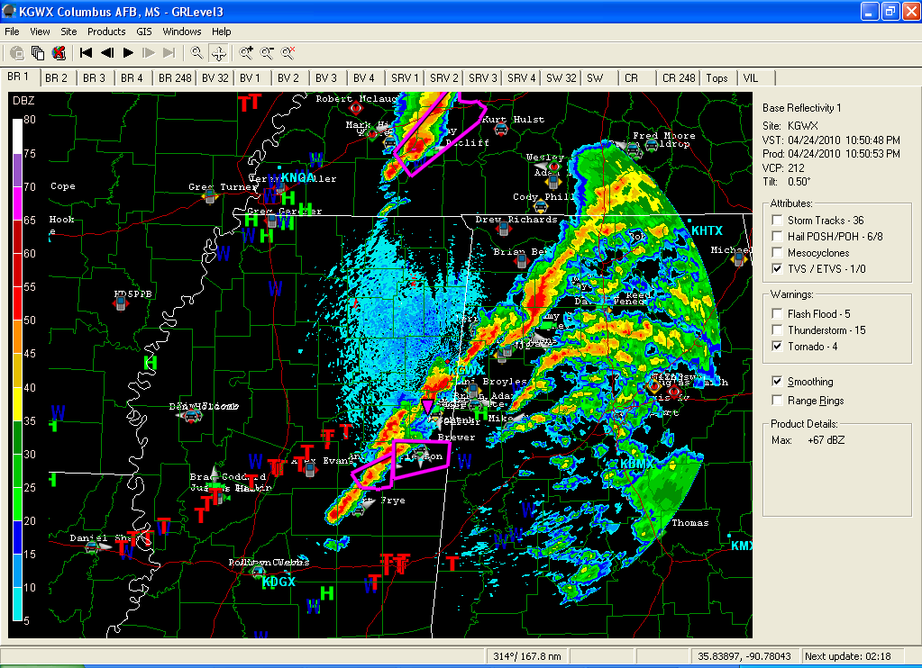
Begint wat los te komen nu. Op het moment staan er een aantal tornadowarnings uit, en zijn er ook een paar mooie cellen op de radar te zien.
Ook al een 'large cone shaped' tornado gemeld.
Ook al een 'large cone shaped' tornado gemeld.

quote:Update: Yazoo City, Miss. tornado destroys businesses, trees down, unknown number of injuries - NBC News
quote:Tornado in Yazoo City, Miss. demolishes buildings; severe tornado warning in effect for southwestern Miss. and Alabama

Zijn genoeg tornado's gemeld idd. En er zullen er vast nog wel meer komen. Staan nog wel een aantal warnings uit.quote:Op zaterdag 24 april 2010 22:41 schreef Roel_Jewel het volgende:
Pic van Yazoo City: http://twitpic.com/1i5g1f.
Zie updates @ http://twitter.com/rodrigobno
Oef het seizoen is echt begonnen. Vorig jaar was het nogal laf, maar dit is helaas een goed begin... Spijtig van het prachtige natuurgeweld dat het meteen ook levens kost  Want het is 1 van de beste wereld wonderen die er is moet ik zeggen...
10 doden inmiddels en waarschijnlijk stijgt het nog.
Een tornado van 1.5 kilometer
[ Bericht 8% gewijzigd door #ANONIEM op 25-04-2010 07:23:57 ]
Een tornado van 1.5 kilometer
quote:A tornado almost a mile wide tore through Mississippi on Saturday, killing at least 10 people and causing significant injuries and damage as it raked cities from the central western border with Louisiana northeastward to Alabama.
Two of the dead were children and one was a 3-month-old baby, according to Mississippi Emergency Management Agency (MEMA) spokesman Jeff Rent.
The death toll is expected to rise as rescue crews reach hard-hit areas where structures have been badly damaged, said another MEMA spokesman, Greg Flynn.
[ Bericht 8% gewijzigd door #ANONIEM op 25-04-2010 07:23:57 ]

In het noorden van Florida momenteel zware onweersbuien.
[ Bericht 25% gewijzigd door #ANONIEM op 25-04-2010 19:55:33 ]
[ Bericht 25% gewijzigd door #ANONIEM op 25-04-2010 19:55:33 ]
Op het moment daar nog steeds zware buien. Verder vooral zware buien in Pennsylvania.quote:Op zondag 25 april 2010 19:49 schreef aloa het volgende:
In het noorden van Florida momenteel zware onweersbuien.


Klopt ja, meer dan een mijl breed. Op www.tornadovideos.net een mooie footage. Flinke schade zeg... Ook 10 doden, niet best.
's Avonds een man, overdags rustig an
Het is gewoon jammer dat sommige staten minder gespecialiseerd zijn in tornado's en het veilig stellen van mensen dan andere staten..
Thx... filmpjes zegquote:Op maandag 26 april 2010 22:16 schreef Burnie88 het volgende:
Klopt ja, meer dan een mijl breed. Op www.tornadovideos.net een mooie footage. Flinke schade zeg... Ook 10 doden, niet best.
Bizar
Komend weekend worden er weer zware buien met tornado's verwacht.
In dezelfde regio als afgelopen zaterdag.
Als er geen weeralarm was geweest, dan waren er veel meer doden gevallen.
In dezelfde regio als afgelopen zaterdag.
Als er geen weeralarm was geweest, dan waren er veel meer doden gevallen.
quote:But there is a silver lining: Without the warnings, Saturday's tornado death toll would likely have been in the hundreds. There were 55 tornadoes in seven states, including one that caused considerable damage in the St. Louis area. Each of these had the potential to cause death or injury.
Een post hierboven zei ik ook al dat staten zoals Mississippi of Alabama minder warnings uitgeven en informatie voorzieningen hebben richting de inwoners. Kijk maar naar Oklahoma / Texas, daar worden tv programma's , radio's shows etc onderbroken voor het weer. Helicopters die naast tornado's vliegen en iedereen die gaat kijken naar het natuur geweld. Heel ander cultuur en ik moet zeggen dat ik het wel erg kon waarderen.quote:Op dinsdag 27 april 2010 19:24 schreef aloa het volgende:
Komend weekend worden er weer zware buien met tornado's verwacht.
In dezelfde regio als afgelopen zaterdag.
Als er geen weeralarm was geweest, dan waren er veel meer doden gevallen.
[..]
quote:The severe weather season continues to heat up, as numerous tornado outbreaks are likely later this week! Tornado chances begin to ramp up Thursday with a possible outbreak of severe weather in the Southern Plains states, with the best tornado chances likely to occur in Oklahoma around sunset. Then, on Friday a high risk for tornadoes appears likely to unfold, centered on Arkansas, Louisiana, and Mississippi. Tornado chances will continue in this region for several days, possibly extending as far west as Oklahoma and as far east as Alabama, as a powerful storm system over the Northern Plains combines extremely rich Caribbean moisture and instability with unusually strong wind shear. Ominously, the latest weather model output from the GFS centers the tornado risk over western Mississippi Friday through Sunday, so workers assisting in the cleanup efforts from Saturday's Yazoo City storm will need to keep a sharp eye on the weather.
However, Mother Nature has another, potentially even more damaging threat in store. As an immense amount of moisture is pulled northward from the tropics, it will collide with a warm front forecast to set up over western Tennessee, northern Mississippi, western Kentucky, and northeast Arkansas. This could lead to a dangerous flash flooding situation as thunderstorms train over the same area for an extended period of time.
Here are images of the 850 mb wind flow Friday through Saturday (left to right), as well as temperature on Saturday and 96-hour cumulative rainfall by Monday. Note how the storm system is pulling air in from deep in the Caribbean, and then depositing it as heavy rainfall in the mid-Mississippi valley near the warm front in northern Mississippi. Stay tuned to TVN for more updates as we follow this dangerous weather situation!
http://www.aolnews.com/na(...)y-this-week/19454495
Momenteel gekkenhuis in de VS. High risk op large tornadoes...
's Avonds een man, overdags rustig an
Live chasebeelden, vanavond kon dat wel eens hele vette beelden gaan opleveren:
http://www.tornadovideos.net/live
http://www.tornadovideos.net/live
's Avonds een man, overdags rustig an
Sowieso tornado's in de namiddag/avond. Waarschijnlijk zeer grote (F4, F5 zit er dik in)... Je bent nu niet blij als je in Mississippi woont.
's Avonds een man, overdags rustig an

Heftig zeg  Ging het wat de afgelopen 12 uur ?
quote:Zeker vijf doden bij overstromingen in Tennessee
Ernstige overstromingen hebben gisteren minstens vijf dodelijke slachtoffers geëist in de Amerikaanse staat Tennessee. Dat heeft de omroep NBC gemeld.
Honderden evacuaties
Over de hele staat waren er overstromingen en hevige regenval. Het natuurgeweld kostte aan zeker vijf mensen het leven, honderden mensen werden geëvacueerd. Overal in Tennessee werden er noodonderkomens ingericht voor mensen die waren gestrand op snel en onverwacht ondergelopen wegen.
Met tornado's is het meegevallen, 'slechts' 13 en voor zover bekend geen killer tornadoes. Maar inderdaad, nog wel ontzettend veel regen/hagel enz. Bizar. Gisteren op de live chasebeelden zag je alleen maar muren van regen, niet voor te stellen.
's Avonds een man, overdags rustig an
Een zware zomerse onweersbui in Nederland doet ook vaak zijn werk. Nadeel daar in Amerika is dat die buien soms 10x zo groot zijn en na een paar uur gewoon nog 1tje kan komen. Hier is het dan vaak ook klaar na 1 fikse knaller.quote:Op zondag 2 mei 2010 14:04 schreef Burnie88 het volgende:
Met tornado's is het meegevallen, 'slechts' 13 en voor zover bekend geen killer tornadoes. Maar inderdaad, nog wel ontzettend veel regen/hagel enz. Bizar. Gisteren op de live chasebeelden zag je alleen maar muren van regen, niet voor te stellen.
Het land daar helpt ook niet mee, zodat er altijd wateroverlast is. Een klein buitje en alles staat gewoon al blank, dat kan je eigenlijk ook niet geloven.
Het is trouwens ook maar een " matig " seizoen qua tornado's. Vooral in centraal Amerika valt het allemaal best mee. Oke die ene zware is natuurlijk ontzettend erg geweest, maar voor de rest is er weinig spektakel geweest.
Maar het seizoen is toch nog lang niet over?quote:Op zondag 2 mei 2010 14:09 schreef Drassss het volgende:
[..]
Een zware zomerse onweersbui in Nederland doet ook vaak zijn werk. Nadeel daar in Amerika is dat die buien soms 10x zo groot zijn en na een paar uur gewoon nog 1tje kan komen. Hier is het dan vaak ook klaar na 1 fikse knaller.
Het land daar helpt ook niet mee, zodat er altijd wateroverlast is. Een klein buitje en alles staat gewoon al blank, dat kan je eigenlijk ook niet geloven.
Het is trouwens ook maar een " matig " seizoen qua tornado's. Vooral in centraal Amerika valt het allemaal best mee. Oke die ene zware is natuurlijk ontzettend erg geweest, maar voor de rest is er weinig spektakel geweest.
's Avonds een man, overdags rustig an


Jemig hee, wat een water!
Vrijdag weer kans op heftig onweer in de VS.
Vrijdag weer kans op heftig onweer in de VS.
's Avonds een man, overdags rustig an
quote:Doden door noodweer zuidoosten VS
***************************************
` Door overstromingen in het zuidoosten
van de Verenigde Staten zijn zeker 19
mensen om het leven gekomen.De staat
Tennessee is het zwaarst getroffen.
Door hoosbuien die al een paar dagen
duren zijn rivieren overstroomd en
staan grote delen van de staat blank.
In verschillende steden zijn hele
woonwijken geëvacueerd.Reddingswerkers
gaan van deur tot deur om mensen uit
hun huis te halen.
Een waterzuiveringsinstallatie is uit
voorzorg gesloten en ingenieurs houden
een lekkende dam in de gaten.Naast
Tennessee zijn er ook mensen omgekomen
in de staten Mississippi en Kentucky.
Never in the entire history of calming down did anyone ever calm down after being told to calm down.

quote:26 deaths in disaster area
At least 26 people have been killed in America's south after severe storms caused flooding and tornados.
Heavy rain in Tennessee caused rivers to burst their banks, forcing thousands to evacuate their homes and overflowing many roads.
As many as 16 people died in the state, with some victims found in submerged vehicles and inundated houses.
Many famous tourist spots in the US country music capital were also flooded, including the Country Music Hall of Fame and the Grand Ole Opry.
Nashville mayor Karl Dean said damage to the city was worse than he had originally thought.
"The magnitude of the damage to our community was much more than what I expected. The safety of some of our infrastructure is questionable," he said.
He also asked residents to conserve water because treatment plants had to be shut down after more than 30cm of rain fell.
Iemand dit nieuwe falende tornado programma op discovery aan het kijken? Mensen die gewoon stormen binnen rijden met camera's en maar gokken waar tornado's zitten enzo? Echt ongelofelijk dit :S
Weet niet of dit het goede topic is maargoed!
Weet niet of dit het goede topic is maargoed!
Je bedoelt toch niet Storm Chasers? Denk het niet, die hebben alle mogelijke weerinfo ter beschikking. Wel lekker link om zo te werk te gaan in ieder gevalquote:Op woensdag 5 mei 2010 22:07 schreef Drassss het volgende:
Iemand dit nieuwe falende tornado programma op discovery aan het kijken? Mensen die gewoon stormen binnen rijden met camera's en maar gokken waar tornado's zitten enzo? Echt ongelofelijk dit :S
Weet niet of dit het goede topic is maargoed!
's Avonds een man, overdags rustig an
Tornado Road, het was gister om 21.35 op tv. Leken die met een laptop met wat internetsites iets van een storm inrijden en maar kijken wat er op hun afkomt :S maar wel denken dat ze geweldig zijn.... Ik heb met afschuw zitten kijken hoe dom hun strategisch plan, of eigenlijk geen plan van ze was...
Storm Chasers is daarin tegen een geweldig programma
Storm Chasers is daarin tegen een geweldig programma
Inderdaad, alleen dit jaargang van Storm Chasers is wat minder omdat er in 2009 gewoon geen heftige tornado's waren. Alleen de laatste aflevering is erg vet (al gezien op youtube). Ik erger me wel een beetje aan die Josh van Storm Chasers, zo ongelovelijk koppig die kerel.quote:Op donderdag 6 mei 2010 10:26 schreef Drassss het volgende:
Tornado Road, het was gister om 21.35 op tv. Leken die met een laptop met wat internetsites iets van een storm inrijden en maar kijken wat er op hun afkomt :S maar wel denken dat ze geweldig zijn.... Ik heb met afschuw zitten kijken hoe dom hun strategisch plan, of eigenlijk geen plan van ze was...
Storm Chasers is daarin tegen een geweldig programma
's Avonds een man, overdags rustig an
Nou geloof me, jij gaat dat Tornado Road programma zeker niet waarderen, omdat al die lui zo erg geilen op onweer/tornado's dat ze niet logisch nadenken dat het best gevaarlijk kan zijn... en als ze er eenmaal inzitten gaan ze voor de camera schreeuwen dat het gevaarlijk is wat ze doen blablaquote:Op donderdag 6 mei 2010 19:30 schreef Burnie88 het volgende:
[..]
Inderdaad, alleen dit jaargang van Storm Chasers is wat minder omdat er in 2009 gewoon geen heftige tornado's waren. Alleen de laatste aflevering is erg vet (al gezien op youtube). Ik erger me wel een beetje aan die Josh van Storm Chasers, zo ongelovelijk koppig die kerel.
Leuke van 2009 seizoen voor mij was, dat ik daar toen zat. Een tornado 28 feb was toen 5 mile van me vandaan. Eén van die kerels ging in zijn eentje 25km verderop die tornado bekijken.
Volgens mij was het een F1, maar had hij wel 1 huis helemaal opgeraapt. Alleen de fundering stond er nog toen ik er langs reed.. Zelf heb ik op de campus waar ik was in de verte iets vaags kunnen zien, maar niet 100% zeker dat het de tornado was.
Morgen wordt er weer extreem weer verwacht.
quote:Violent tornado outbreak to endanger Plains Monday
.Lives and property will become endangered across the central and southern Plains on Monday as a violent outbreak of tornadoes erupts.
Tornadoes will start touching down Monday afternoon across south-central Kansas and west-central Oklahoma. This includes Wichita, Kan., and Oklahoma City.
It is not out of the question that an isolated tornado or two is also sighted in central Texas from Wichita Falls to San Angelo.
The tornado threat will shift to northeastern Oklahoma, eastern Kansas and western Missouri early Monday night. In this danger zone lies Tulsa, Okla., Chanute, Kan., and Kansas City, Mo.
The potential exists for these tornadoes to be extremely large and long-tracking. One or more of these tornadoes could leave a trail of death and destruction, similar to the deadly tornado that tore through central Mississippi in late April.
However, a tornado does not have to be on the ground for dozens of miles to cause devastation. Loss of life and damage could happen if just one tornado rips through one community.
The tornado danger will not be confined to residents of the central and southern Plains. Motorists traveling on interstates 35, 40, 44 and 70 will also be threatened. Remember, your vehicle is one of the worst places to be during a tornado.
Seek shelter immediately if a tornado siren sounds or a tornado warning is issued for the area you reside at or are traveling through. Be sure to stay alert and not sleep through these warnings Monday night.
The powerful thunderstorms threatening to spawn the violent tornadoes could also produce strong winds, hail and downpours.
The winds could overturn semi-trucks and campers, as well as damage trees and structures. The hail will be large enough to shatter windows of homes and vehicles, and could injure people and livestock.
The threat of tornadoes will become more isolated late Monday night as the severe weather shifts toward the Mississippi River in Missouri. Damaging winds and hail will become the greater dangers.

Dat wordt weer heftig morgen...
Ik zit nu Tornado Road te kijken. Inderdaad erg amateuristisch Drasss. Ik erger me na een kwartier kijken al aan die kale homo. Beetje wijs lopen doen bovenop een heuvel met heftig veel blikseminslagen om hem heen. En kijk hem eens stoer zijn... Daarentegen wel gave beelden!
Ik zit nu Tornado Road te kijken. Inderdaad erg amateuristisch Drasss. Ik erger me na een kwartier kijken al aan die kale homo. Beetje wijs lopen doen bovenop een heuvel met heftig veel blikseminslagen om hem heen. En kijk hem eens stoer zijn... Daarentegen wel gave beelden!
's Avonds een man, overdags rustig an