WKN Weer, Klimaat en Natuurrampen
Lees alles over het onstuimige weer op onze planeet, volg orkanen en tornado's, zie hoe vulkanen uitbarsten en hoe Moeder Aarde beeft bij een aardbeving. Alles over de verwoestende kracht van onze planeet en tal van andere natuurverschijnselen.


Ja, waarschijndelijk zelfs zwaar onweerquote:Op zondag 13 mei 2007 02:32 schreef MissHobje het volgende:
Komt er onweer ??
Ohh das wel tof..
En ja ik zat niet op te letten enzo
Weet je, ik gun heel NL een dikke wolkbreuk van 1 uur lang, veel onweer en storm.quote:Op zondag 13 mei 2007 02:32 schreef Xenwolfie het volgende:
[..]
En mij hoop je niks toe he, gemenerik! .
* Xenwolfie voegt SpeedyGJ toe aan zijn lijstje voor het geval het geen noodweer wordt .
Neerslag: 140mm!
Bliksem: 100 per 10 sec!
Wind: 100km/h gemiddeld.
Windstoten: 150km/h!
Zo
Doe mee met het voorspellen van het weer!
Weekvoorspelling | Week 41 (Inschrijven tot 6-10, 11:59)
Maandvoorspelling oktober (Gesloten)
Jaarvoorspelling 2024 / 2025
Weekvoorspelling | Week 41 (Inschrijven tot 6-10, 11:59)
Maandvoorspelling oktober (Gesloten)
Jaarvoorspelling 2024 / 2025
en wanneer ongeveer?
Ik ben vanmiddag op visite bij familie.. ( soort tuin achtig feest) en dan peer ik hem dus op tijd
Ik ben vanmiddag op visite bij familie.. ( soort tuin achtig feest) en dan peer ik hem dus op tijd
[b]Hobbelicious is back!
[/b]
[/b]
We krijgen eerst te maken met een flinke regenband. In de ochtend begint in het zuiden te regenen, deze trekt redelijk snel naar het noorden. Daarachter klaart het op, maar dan komen de buien, dus rond 14:00 / 15:00 zouden de buien dus ongeveer het zuiden bereiken, deze breiden zich dan uit over het hele land. Het noorden krijgt hier in de avond pas mee te maken, waardoor nachterlijk onweer daar mogelijk het grootst is omdat er niet al te veel wind staat, zullen er geen zware windstoten voor komen, hooguit 50km/h, daar houd het ook wel mee opquote:Op zondag 13 mei 2007 02:39 schreef MissHobje het volgende:
en wanneer ongeveer?
Ik ben vanmiddag op visite bij familie.. ( soort tuin achtig feest) en dan peer ik hem dus op tijd
Doe mee met het voorspellen van het weer!
Weekvoorspelling | Week 41 (Inschrijven tot 6-10, 11:59)
Maandvoorspelling oktober (Gesloten)
Jaarvoorspelling 2024 / 2025
Weekvoorspelling | Week 41 (Inschrijven tot 6-10, 11:59)
Maandvoorspelling oktober (Gesloten)
Jaarvoorspelling 2024 / 2025
Ow crap ik zit in brabant rond die tijd
Zul je net zien dat ik thuis veel krijg ofzo
Ja of daar
Thanks.. en we wachten het maar af
Zul je net zien dat ik thuis veel krijg ofzo
Ja of daar
Thanks.. en we wachten het maar af
[b]Hobbelicious is back!
[/b]
[/b]
Wie wat allemaal gaat krijgen is nog maar even de vraag, dus ja, kan zijn dat het zuiden het meeste krijgt, maar kan ook het oosten zijn of het noorden, of iedereen krijgt wat
Doe mee met het voorspellen van het weer!
Weekvoorspelling | Week 41 (Inschrijven tot 6-10, 11:59)
Maandvoorspelling oktober (Gesloten)
Jaarvoorspelling 2024 / 2025
Weekvoorspelling | Week 41 (Inschrijven tot 6-10, 11:59)
Maandvoorspelling oktober (Gesloten)
Jaarvoorspelling 2024 / 2025
De wind, ik ga me terug trekken. We gaan dus toch wel zware windstoten krijgen. De wind gaat namelijk toenemen naar kracht 5 in het binnenland tot 7 langs de kust.
Doe mee met het voorspellen van het weer!
Weekvoorspelling | Week 41 (Inschrijven tot 6-10, 11:59)
Maandvoorspelling oktober (Gesloten)
Jaarvoorspelling 2024 / 2025
Weekvoorspelling | Week 41 (Inschrijven tot 6-10, 11:59)
Maandvoorspelling oktober (Gesloten)
Jaarvoorspelling 2024 / 2025
De CAPE is wel wat lafjes. Maar goed, het kan goed tekeer gaan op de rand van de koude en warme lucht. (30 graden in zuid Duitsland)
Onweer zou leuk zijn, van de week ook al zo'n 2 uur non stop onweer gehad in Nijmegen.
Onweer zou leuk zijn, van de week ook al zo'n 2 uur non stop onweer gehad in Nijmegen.

Wat zijn we aan het doen ???
Dan ik ook maar
Doe mee met het voorspellen van het weer!
Weekvoorspelling | Week 41 (Inschrijven tot 6-10, 11:59)
Maandvoorspelling oktober (Gesloten)
Jaarvoorspelling 2024 / 2025
Weekvoorspelling | Week 41 (Inschrijven tot 6-10, 11:59)
Maandvoorspelling oktober (Gesloten)
Jaarvoorspelling 2024 / 2025
Ik hou ook van Formule1, maar onweer gaat toch voor hoor.quote:Op zondag 13 mei 2007 03:14 schreef TommyGun het volgende:
Zolang 't signaal tijdens de Formule eins maar niet wegvalt
quote:Op zondag 13 mei 2007 03:15 schreef ReWinD het volgende:
[..]
Ik hou ook van Formule1, maar onweer gaat toch voor hoor.
Maar na en voor F1 mag 't zoveel onweren en regenen als wie ook maar wil
Als het voor de race gaat onweren kan het signaal alsnog wegvallen en heb je nog geen beeld tijdens de racequote:Op zondag 13 mei 2007 03:16 schreef TommyGun het volgende:
[..]
Maar na en voor F1 mag 't zoveel onweren en regenen als wie ook maar wil
8 knallende blikseminslag zodat letterlijk alle zenders uit de lucht zijn
Doe mee met het voorspellen van het weer!
Weekvoorspelling | Week 41 (Inschrijven tot 6-10, 11:59)
Maandvoorspelling oktober (Gesloten)
Jaarvoorspelling 2024 / 2025
Weekvoorspelling | Week 41 (Inschrijven tot 6-10, 11:59)
Maandvoorspelling oktober (Gesloten)
Jaarvoorspelling 2024 / 2025
Owja, stom van me. Tijdstip enzoquote:Op zondag 13 mei 2007 03:17 schreef ReWinD het volgende:
[..]
Als het voor de race gaat onweren kan het signaal alsnog wegvallen en heb je nog geen beeld tijdens de race
Inderdaad, gewoon de hele dag geen TVquote:Op zondag 13 mei 2007 03:19 schreef SpeedyGJ het volgende:
8 knallende blikseminslag zodat letterlijk alle zenders uit de lucht zijn
Heerlijk..
Inderdaad! Het oosten heeft heel de tijd al geluk, nu zijn wij eens aan de beurt!quote:Op zondag 13 mei 2007 01:35 schreef Xenwolfie het volgende:
WAT HOOR IK NU ZWAAR ONWEER??
ALS HET NOU NIET IN HET WESTEN KOMT GAAN ER DODEN VALLEN!!!
[
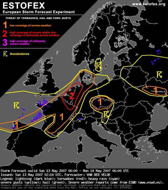
Damn. Een combi van 1 oktober 2006 en 17 juli 2004 !1!!1!?????quote:Storm Forecast
Valid: Sun 13 May 2007 06:00 to Mon 14 May 2007 06:00 UTC
Issued: Sun 13 May 2007 02:14
Forecaster: VAN DER VELDE
SYNOPSIS
A significant low pressure system is forecast to move from the Atlantic west of France to the English Channel region and Denmark. The axis of a strong upper jet is predicted to cross Galicia, western France and the Benelux. At the time of strongest diurnal heating, the nose of the jet will be situated over northern France, with very high speeds also in the lower levels: 25 m/s at 850 and more than 30 m/s at 700 hPa forecast by GFS 18Z.
Models predict a few hundred J/kg MLCAPE in the warm sector, also near the frontal wave over Belgium at 15Z (GFS, NMM, MM5). The timing, location and magnitude of CAPE and shear has varied slightly over the past few GFS runs, but the presence of instability, shear and forcing has remained constant and indicative of a significant severe weather episode.
DISCUSSION
...France, Benelux, western Germany...
Scattered convection under weak instability is expected to occur during the morning hours over western France, which can already profit from strong vertical shear conditions (deep low level) and create isolated severe weaher as gusts or a tornado. As the day proceeds, forcing and heating are expected to increase and start to build more organised and stronger convection around Paris and near the wave over Belgium. With 0-6 km shear vectors around 25-30 m/s, 1-8 km vectors of 15-20 m/s, 0-1 km vectors of 12-17 m/s and veering winds with height yielding more than 200 m2/s2 0-3 km SREH (even over 400 m2/s2 along the warm front north of the instability), supercells are very likely and will have a good probability to produce tornadoes (lowest LCLs, strongest LL shear over Benelux), as well as large hail and severe gusts in the level 2 area.
In the level 2 area, the deep layer shear vector is under some angle with the forcing, as judged from GFS mixing ratio advection fields, which is favourable for discrete cells initially, until the late afternoon, when cells are likely to merge and form a squall line, which will be effective in transferring strong wind speeds to the surface over a large area, thought to warrant a level 2. This system will proceed to affect the Netherlands and western Germany during the evening and move rapidly northward. It should lose strength when reaching Denmark. A somewhat limiting factor is instability and probably not very dry air except over Germany.
The 12Z sounding of Trappes should become representative of the environment.
...central and southern France...
More isolated storms are expected here after about 15Z along the front, with weaker low level shear southward but stronger deep layer shear, and SREH still higher than 100-200 m2/s2 giving a high probability that cells will develop more persistent mesocyclones or split. Large hail is the primary threat here. Severe gusts can occur helped by cold downdrafts (>12 degrees negative buoyancy at surface). During the evening, a band a enhanced low level shear may increase tornado chances a bit over the northeastern Massif Central. As the shear vector is much parallel to the front here, storms may have formed a line by then.
...Czech area...
GFS and MM5 have indicated some convective precipitation here. While there should be quite considerable instability and favourable deep layer shear and SREH, chances seem a bit slim as no clear forcing is going to be present... perhaps orography. Would not exclude Bavaria totally... an update may be required but everything is likely staying localized. The warm front might set off a storm near the Czech/Polish border during the evening if GFS has it right. Large hail would be the primary threat in this area.
...Ukraine...
Another area where the jet crosses slight instability. >100 m2/s2 SREH and >20 m/s 0-6 km shear, so a few storms may display rotation and a slight chance of marginally large hail. A weak shortwave trough provides lift.
...Galicia, northern Portugal...
Have indicated area of slight instability crossed by deep layer/low level shear. Not much over land though.
1 oktober was een leuke onweersdag... er kwam bestwel wat actief onweer voorbij.
1 oktober is tevens m'n verjaardag dus de weergoden hebben aan me gedacht.
Sounding voor mijn omgeving:
Lekker vochtig tot ver in de hoogte en lekkere windshear.
Wat wil '80' zeggen op dit plaatje?
[ Bericht 23% gewijzigd door DemonRage op 13-05-2007 12:02:41 ]
1 oktober is tevens m'n verjaardag dus de weergoden hebben aan me gedacht.
Sounding voor mijn omgeving:

Lekker vochtig tot ver in de hoogte en lekkere windshear.

Wat wil '80' zeggen op dit plaatje?
[ Bericht 23% gewijzigd door DemonRage op 13-05-2007 12:02:41 ]
Geeft de 0-6 km shear aan.quote:Op zondag 13 mei 2007 11:49 schreef DemonRage het volgende:
1 oktober was een leuke onweersdag... er kwam bestwel wat actief onweer voorbij.
[...]
[afbeelding]
Wat wil '80' zeggen op dit plaatje?
Ah nu zie ik het ook... 0-6km shear in knopen
Dat zal dan wel de toename in wind zijn van 0 tot 6km
En de gekleurde vlakken zijn low-level sheer.
Dan is dit nog interessanter:
een 0,5-gebied boven o.a. België en zuid-Limburg en het schampt het zuiden van Nederland. Zo nauw komt het denk ik ook weer niet. Het schijnt dat 0,5 nog niet zo'n heel boeiende waarde is.
[ Bericht 31% gewijzigd door DemonRage op 13-05-2007 12:35:42 ]
Dat zal dan wel de toename in wind zijn van 0 tot 6km
En de gekleurde vlakken zijn low-level sheer.
Dan is dit nog interessanter:

een 0,5-gebied boven o.a. België en zuid-Limburg en het schampt het zuiden van Nederland. Zo nauw komt het denk ik ook weer niet. Het schijnt dat 0,5 nog niet zo'n heel boeiende waarde is.
[ Bericht 31% gewijzigd door DemonRage op 13-05-2007 12:35:42 ]
Goeiemorgen. Ik hoop dat het echt los gaat, ik heb hoge verwachtingen met die 2 op de kaart.
Ich bin der Führer.
http://www.meteox.nl/h.aspx?r=&jaar=-3&soort=loop1uur
Ik vraag me af waar die zware buien dan zijn, wat er nu komt is een regengebiedje?
Ik vraag me af waar die zware buien dan zijn, wat er nu komt is een regengebiedje?
Ich bin der Führer.
Eerst trekt er een warmtefront over met bijbehorend regengebiedje, daarna zal het opklaren en kunnen er plaatselijk al buien gaan ontstaan, later trekt er nog een koufront over waarop het zwaardere werk kan zitten geloof ik.
Dat warmtefront maakt alleen niet echt haast, vraag me af of het niet wat sneller zou moeten gaan voor de ontwikkeling van buien later.
Dat warmtefront maakt alleen niet echt haast, vraag me af of het niet wat sneller zou moeten gaan voor de ontwikkeling van buien later.
silence can say more than thousand words
Die 2e lijn die je ziet op meteox is volgens mij het koufront.
silence can say more than thousand words
quote:Op zondag 13 mei 2007 12:34 schreef 61neorej het volgende:
Die 2e lijn die je ziet op meteox is volgens mij het koufront.

Dit plaatje komt daarmee overeen.
http://www.bbc.co.uk/weather/ukweather/warnings.shtml :
(10.00 uur Engelse tijd)
quote:Latest UK Weather and Flood Warnings
Sunday 13 May WEATHER WARNING Outbreaks of heavy and thundery rain will affect Devon and Cornwall this morning. Up to 40mm of rain is possible in places and this may cause some disruption, particulary for road users. Valid until 1400BST
Sunday 13 May WEATHER WATCH Heavy and thundery rain will spread from the south across England and Wales today. Up to 40mm is possible in places and this may cause some disruption Further updates will appear here.

(10.00 uur Engelse tijd)
Iddquote:Op zondag 13 mei 2007 12:23 schreef DemonRage het volgende:
Ah nu zie ik het ook... 0-6km shear in knopen
[...]
een 0,5-gebied boven o.a. België en zuid-Limburg en het schampt het zuiden van Nederland. Zo nauw komt het denk ik ook weer niet. Het schijnt dat 0,5 nog niet zo'n heel boeiende waarde is.
Heb het ook ff op weerwoord geplaatst, de groene lijn is het koufront en volgens mij kunnen er prefrontale buien ontstaan in het oranje gebied. Plus de squalline van het koufront groeit aan de zuidzijde nog steeds aan. (richting Spanje) Als het goed is zwabbert die lijn over het hele land vanavond. Maar ik hoop natuurlijk dat die prefrontale buien die moeten onstaan in het oranje gebied al wat spektakel met zich meebrengen
En dat regengebiedje, ach ja, misschien tempert dat wel even de opwarming. Maar het geeft wel vocht (brandstof) om het daarna nog even te doen ontploffen. Op 17 juli 2004 kwam er ook nog even een flink regengebied over het midden/oosten om daarna helemaal los te gaan op het koufront zelf.
En dat regengebiedje, ach ja, misschien tempert dat wel even de opwarming. Maar het geeft wel vocht (brandstof) om het daarna nog even te doen ontploffen. Op 17 juli 2004 kwam er ook nog even een flink regengebied over het midden/oosten om daarna helemaal los te gaan op het koufront zelf.

Wat zijn we aan het doen ???
Wat een raar weer zeg. Om 10 uur de deur uitgegaan en tot 12:15 buiten geweest. Geen wind, eerst nog redelijk wat zon. Eerst jas uit, toen ook maar mijn trui, beetje klef in de stad
Kom maar op met dat onweer
Kom maar op met dat onweer
[b]Op maandag 6 september 2010 00:28 schreef tong80 het volgende:[/b]
GVD Wat moet jij een trotse vader zijn :)
:P
GVD Wat moet jij een trotse vader zijn :)
:P
Dat is waarschijnlijk de squalline die aan het eind van de dag over kan gaan trekken.
Als dat ding nog de hele dag blijft aansterken kunnen we hier nog wel wat verwachten .
Als dat ding nog de hele dag blijft aansterken kunnen we hier nog wel wat verwachten .
In Frankrijk een deel van het land ook code oranje vanwege onweer zie ik nu.
[b]Op maandag 6 september 2010 00:28 schreef tong80 het volgende:[/b]
GVD Wat moet jij een trotse vader zijn :)
:P
GVD Wat moet jij een trotse vader zijn :)
:P
Als het warmtefront een beetje vaart maakt, dan kan het tussen de fronten door de temperatuur nog een beetje stijgen...
Belgie ook, en voor zuid-oost nederland heeft het knmi een waarschuwing gegeven voor (zeer) zware windstoten.
silence can say more than thousand words
http://www.knmi.nl/VinkCMS/news_detail.jsp?id=36300 :
quote:De Bilt heeft inmiddels al zeker 90 mm aan meiregen opgevangen. De komende dagen komt er nog heel wat bij, waarmee deze mei bij de tien natste belandt. In veel landen zijn waarschuwingen van kracht voor onweer en wind (zie Meteoalarm.eu)
Beter komt dat ding gewoon over heel Nederland.quote:Op zondag 13 mei 2007 12:51 schreef i2Them2 het volgende:
Dat is waarschijnlijk de squalline die aan het eind van de dag over kan gaan trekken.
Als dat ding nog de hele dag blijft aansterken kunnen we hier nog wel wat verwachten .
Ich bin der Führer.

Kewl!!! kolkende luchten.
Het zeikt hier een beetje buiten... warmtefront is iig al gearriveerd, en nou snel weg ermee.
Het zeikt hier een beetje buiten... warmtefront is iig al gearriveerd, en nou snel weg ermee.
Mooie wolken .quote:Op zondag 13 mei 2007 13:05 schreef Oom_Agent het volgende:
fotootje van het buiengebied in Frankrijk aan de westkust om 11:16 uur
[afbeelding]
De lucht in het zuiden is vrij donker, volgens mij arriveert het warmtefront in Krimpen en Rotterdam.
Ich bin der Führer.
Estofex geeft inmiddels de hele benelux code rood:
Volgens mij was het net nog alleen Nederland toch?
Volgens mij was het net nog alleen Nederland toch?
Ich bin der Führer.
leuke site dat infoclimat iddquote:Op zondag 13 mei 2007 13:05 schreef Oom_Agent het volgende:
fotootje van het buiengebied in Frankrijk aan de westkust om 11:16 uur
[afbeelding]
Alle foto's kan je hier vinden:
http://www.infoclimat.fr/multimedia/photolive.php?start=&d=&motcle=®ion=&dept=&auteur=&ord=
[b]Op maandag 6 september 2010 00:28 schreef tong80 het volgende:[/b]
GVD Wat moet jij een trotse vader zijn :)
:P
GVD Wat moet jij een trotse vader zijn :)
:P
Dat warmtefront stelt ook geen klap meer voor, hier nu slechts zeer licht gemiezer.
silence can say more than thousand words