WKN Weer, Klimaat en Natuurrampen
Lees alles over het onstuimige weer op onze planeet, volg orkanen en tornado's, zie hoe vulkanen uitbarsten en hoe Moeder Aarde beeft bij een aardbeving. Alles over de verwoestende kracht van onze planeet en tal van andere natuurverschijnselen.


Dat ik dit topic nu pas zie. Ik moet dit topic maar eens in de gaten houden, tenslotte woon ik 20 miles van de kust van de golf van mexico (noord-florida).

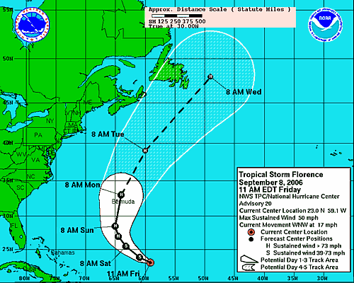
Florence is nog steeds een Tropical Storm en wordt, als het goed is, dit weekend een Orkaan. Volgens het laatste plaatje gaat ie richting Bermuda.

Ze hebben wel grote plannen met Florence, als je kijkt naar waar ze die woensdag verwachten. En dan ook naar de locatie van dinsdag.quote:Op vrijdag 8 september 2006 17:38 schreef aloa het volgende:
Florence is nog steeds een Tropical Storm en wordt, als het goed is, dit weekend een Orkaan. Volgens het laatste plaatje gaat ie richting Bermuda.
[afbeelding]

Als orkaan komt ie wel hoog terecht. Waarschijnlijk zal ie ergens in Europa uitkomen. Maar dan als depressie.quote:Op vrijdag 8 september 2006 22:36 schreef Light het volgende:
[..]
Ze hebben wel grote plannen met Florence, als je kijkt naar waar ze die woensdag verwachten. En dan ook naar de locatie van dinsdag.

Hurricane Florence komt morgemiddag (nl-tijd) langs Bermuda.
zal nog aansterken tot een sterke categorie 2 hurricane.
zal nog aansterken tot een sterke categorie 2 hurricane.

Dostojewski: "Je kunt je niet van je eigen gezond verstand overtuigen door je buurman op te sluiten."
(CNN) -- Tropical storm Florence intensified into a Category 1 hurricane Sunday as it cut a path through the Atlantic and headed toward Bermuda with winds gusting up to 75 miles per hour, National Hurricane Center forecasters said Sunday.
The storm's center was about 360 miles south of the tiny British territory, moving north-northwest, the NHC said. Forecasters warn of storm force winds could reach 260 miles from its epicenter.
Bermuda residents should be making preparations to protect their lives and property as the storm system inched closer to the small island chain, The Bermuda Weather Service warned earlier.
NHC forecasters kept a Hurricane Watch and Tropical Storm Warning in effect for Bermuda, which means hurricane and tropical storm conditions are expected within 24 to 36 hours. A hurricane warning will likely be issued later Sunday.
Florence was ranked as a Category 1 Hurricane at 2 a.m., but forecasters predicted the storm could strengthen to a Category 2 storm, with winds in excess of 96 mph, when is passes near Bermuda early Monday.
Large ocean swells of up to 8 feet and dangerous surf, including rip currents, were affecting Bermuda's coast, as well as the northern Leeward Islands, the Virgin Islands, Puerto Rico, Hispaniola and Bermuda, the hurricane center said.
Weather forecasters in Bermuda said on its current track, the center of Florence could pass less than 10 miles from the islands. However, because of the erratic nature of hurricane movement, such long-range predictions can vary.
The storm is still not seen as a threat to the U.S. East Coast because it is expected to veer off to the northeast, out into the Atlantic Ocean, after passing Bermuda.
CNN


Florence is now just west of Bermuda and there are reports that hurricane force winds are being experienced on the small Atlantic island. Later today, the hurricane will begin to pull away and conditions will slowly improve. Until that time, strong winds, heavy rains and a storm surge along with battering waves will continue to affect Bermuda- we will keep an eye out for reports of damage from the island. Once Florence passes Bermuda it looks as though it will quickly move out in to the Atlantic on a path just south of the Canadian Maritimes. It is possible that large ocean swells will affect the East Coast and portions of the NE Caribbean over the next few days- these affects too will begin to subside as the week wears on.
Elsewhere, we are tracking TD #7 which is expected to become a tropical storm as it too is forecast to curve away from the United States. It is also possible that this depression will simply be torn apart by strong winds aloft and may not be an issue at all. In either case, we will be on top of the latest info from the NHC as this newest system evolves. In addition, there is a very strong tropical wave about to hit the water just off the coast of Africa which should go on to develop as it begins its track to the west. Most models show this feature getting turned out in to the Atlantic but it is quite early to know for sure- so we'll just have to watch and track. One things is for sure, the season is getting very active this week which is completely normal and quite expected. So far, there are no indications that any of the developing systems will affect land anytime soon. Once Florence moves on, we will look closer at the developing systems in the Atlantic. I will post another update here later this afternoon.
Elsewhere, we are tracking TD #7 which is expected to become a tropical storm as it too is forecast to curve away from the United States. It is also possible that this depression will simply be torn apart by strong winds aloft and may not be an issue at all. In either case, we will be on top of the latest info from the NHC as this newest system evolves. In addition, there is a very strong tropical wave about to hit the water just off the coast of Africa which should go on to develop as it begins its track to the west. Most models show this feature getting turned out in to the Atlantic but it is quite early to know for sure- so we'll just have to watch and track. One things is for sure, the season is getting very active this week which is completely normal and quite expected. So far, there are no indications that any of the developing systems will affect land anytime soon. Once Florence moves on, we will look closer at the developing systems in the Atlantic. I will post another update here later this afternoon.
Hurricane Florence treft Bermuda
11 september 2006 - Hurricane Florence heeft maandag flink huisgehouden op Bermuda. Florence is een klasse 1 hurricane met gemiddelde windsnelheden tussen 90 en 150 km/uur.
De hurricane trekt nu op ruime afstand van de Amerikaanse oostkust verder in noordelijke richting om daarna af te buigen naar het noordoosten. Naar verwachting transformeert het tropische systeem Florence woensdag nabij New Foundland in een extratropische depressie en worden de restanten vervolgens in de zonale stroming op de Oceaan opgenomen. Daardoor wordt het eind deze week ook in ons land wisselvalliger met kans op buien en mogelijk ook meer wind.
Inmiddels is de zevende tropische depressie in ontwikkeling en dat kan Gordon worden. De komende weken krijgen ook de Verenigde Staten vaker te maken met hurricanes die aan land gaan.
Website KNMI
[ Bericht 0% gewijzigd door #ANONIEM op 11-09-2006 22:18:51 ]
11 september 2006 - Hurricane Florence heeft maandag flink huisgehouden op Bermuda. Florence is een klasse 1 hurricane met gemiddelde windsnelheden tussen 90 en 150 km/uur.
De hurricane trekt nu op ruime afstand van de Amerikaanse oostkust verder in noordelijke richting om daarna af te buigen naar het noordoosten. Naar verwachting transformeert het tropische systeem Florence woensdag nabij New Foundland in een extratropische depressie en worden de restanten vervolgens in de zonale stroming op de Oceaan opgenomen. Daardoor wordt het eind deze week ook in ons land wisselvalliger met kans op buien en mogelijk ook meer wind.
Inmiddels is de zevende tropische depressie in ontwikkeling en dat kan Gordon worden. De komende weken krijgen ook de Verenigde Staten vaker te maken met hurricanes die aan land gaan.

Website KNMI
[ Bericht 0% gewijzigd door #ANONIEM op 11-09-2006 22:18:51 ]


Shanshan neemt inderdaad flink in kracht toe.quote:Op dinsdag 12 september 2006 11:29 schreef Frutsel het volgende:
En Shanshan zal deze week korte metten gaan maken met de eilandengroep rondom Okinawa Japan?
[afbeelding]


Ja maar niet naar Nederland helaas
<a href="https://www.youtube.com/channel/UCPueUwKfPaGH7v48LZlltkg" rel="nofollow" target="_blank">WSDokkum Youtube</a>
ja eerst over de Azoren morgen als hurricane nog, en die zijn van Portugal inderdaad.
quote:A HURRICANE WARNING IS IN EFFECT FOR ALL OF THE AZORES ISLANDS. A
HURRICANE WARNING MEANS THAT HURRICANE CONDITIONS ARE EXPECTED
WITHIN THE WARNING AREA WITHIN THE NEXT 24 HOURS. PREPARATIONS TO
PROTECT LIFE AND PROPERTY SHOULD BE RUSHED TO COMPLETION.
Dostojewski: "Je kunt je niet van je eigen gezond verstand overtuigen door je buurman op te sluiten."
Kom maar op met de automatische weerstations links
<a href="https://www.youtube.com/channel/UCPueUwKfPaGH7v48LZlltkg" rel="nofollow" target="_blank">WSDokkum Youtube</a>
pas op, voor dat je het weet krijg je weer een briefquote:Op dinsdag 19 september 2006 22:30 schreef SpeedyGJ het volgende:
Kom maar op met de automatische weerstations links