WKN Weer, Klimaat en Natuurrampen
Lees alles over het onstuimige weer op onze planeet, volg orkanen en tornado's, zie hoe vulkanen uitbarsten en hoe Moeder Aarde beeft bij een aardbeving. Alles over de verwoestende kracht van onze planeet en tal van andere natuurverschijnselen.


http://content.wdtinc.com(...)0164&C=20226&O=10190
Misschien aardige beelden over een aantal minuten, omdat een cell over hun heen gaat trekken.
Misschien aardige beelden over een aantal minuten, omdat een cell over hun heen gaat trekken.
En de storm chasers zijn als bezetenen aan het rijden. Jammer dat Fox niet streamed.quote:Op vrijdag 3 februari 2012 20:36 schreef Drassss het volgende:
Prachtige cell aan het ontwikkelen in Texas, omgeving van Archer City.
Kris Hair zit in de buurt en is streaming. en ook down.
[ Bericht 3% gewijzigd door MaryMouse op 03-02-2012 21:02:03 ]
You better lose yourself in the music
The moment, you own it, you better never let it go
The moment, you own it, you better never let it go
quote:
quote:
http://content.wdtinc.com(...)0164&C=20226&O=10061
Cell mooi in beeld.
You better lose yourself in the music
The moment, you own it, you better never let it go
The moment, you own it, you better never let it go
quote:Powerful Storms Target South Wednesday
The threat for severe thunderstorms will return to parts of the South by midweek as a new storm system emerges.
As was the case a few weeks ago, the storm system may prove strong enough to generate thunderstorms that could spin up tornadoes.
Areas from eastern Texas into the lower Mississippi Valley and Deep South will be threatened by these storms, expected to fire as a cold front pushes east on Wednesday and Wednesday night.
The front will encounter an atmosphere rich with moisture from the Gulf of Mexico, which combined with warm temperatures in place will help trigger the storms.
Specifically, the Interstates 10, 20 and 30 corridors, including Houston, Texas; Baton Rouge, New Orleans and Shreveport, La.,; Memphis, Tenn.; and Jackson, Miss., are at risk of some of these storms turning gusty.
Wind gusts to 50 mph, large hail and always dangerous lightning will accompany the stronger storms, all coming with the possibility of causing property damage.
Downpours from storms will limit visibility as well, creating a hazard in itself for motorists caught in thunderstorms.
Since marine activity is year round across southern lakes and in the Gulf, any mariners should keep an eye to the sky and seek safe harbor at the first sign of a storm. Lightning is among the top killers of boaters.
There are also some indications that conditions could be favorable for a tornado or two to form from thunderstorms.
Even the slightest risk for a tornado should be taken seriously, and residents and visitors alike should monitor the situation throughout the day just in case.
quote:

Mogelijkheden voor een opschaling, we wachten de updates af vandaag.quote:THE ECMWF HAS BEEN MORE SUGGESTIVE THAN THE OTHER MODELS OF
POTENTIAL FOR SIGNIFICANT SURFACE CYCLONE DEEPENING ACROSS THE
MIDDLE MISSISSIPPI VALLEY WEDNESDAY NIGHT...PERHAPS AIDED BY PHASING
OF THE SOUTHERN BRANCH IMPULSE WITH A DIGGING NORTHERN BRANCH
TROUGH. IF THIS OCCURS...STRONGER SURFACE PRESSURE FALLS COULD AID
BOUNDARY LAYER DESTABILIZATION ACROSS MISSISSIPPI AND ALABAMA...WITH
STRONGER SOUTHERLY 850 MB FLOW ALSO CONTRIBUTING TO LARGE AND
CLOCKWISE CURVED LOW-LEVEL HODOGRAPHS. THIS WOULD PROVIDE POTENTIAL
FOR A GREATER SEVERE RISK THAN CURRENTLY INDICATED...INCLUDING THE
POSSIBILITY OF A STRONG TORNADO OR TWO.
Zeker geen outbreak, maar een kleine kans (5%) op een verdwaalde tornado.quote:Powerful Storms Threaten Houston, New Orleans
The threat for severe thunderstorms will return to parts of the South today and tonight as a new storm system takes shape over the Plains.
As was the case a few weeks ago, the storm system may prove strong enough to generate thunderstorms that could spin up tornadoes.
Areas from eastern Texas into the lower Mississippi Valley and Deep South will be threatened by these storms, expected to fire as a cold front pushes east later this afternoon into tonight.
Bron: http://www.accuweather.co(...)s-severe-storm/61682quote:Violent Storms to Hit New Orleans to Tallahassee Saturday
There is potential for the most violent severe storm outbreak of the season so far to unfold Saturday from southeastern Louisiana to southern Georgia and the Florida Panhandle.
Thunderstorms will first fire across the western Gulf Coast from southern and eastern Texas into Louisiana tonight as a storm system now situated over northwestern Mexico gathers strength in the Gulf of Mexico.
The early risk from the developing weather pattern is blinding downpours and the potential for flash flooding. Houston is included in the communities at risk for heavy thunderstorms.
All of the ingredients will come together for a severe storm outbreak on Saturday as the storm system pushes across the central Gulf states.
quote:There is also a risk of a couple of tornadoes occurring farther inland, among clusters of thunderstorms. These storms could be wrapped in heavy rainfall and concealed from view.

Bron: Accuweather
You better lose yourself in the music
The moment, you own it, you better never let it go
The moment, you own it, you better never let it go
Stuur even door hier heen wil je 
<a href="https://www.youtube.com/channel/UCPueUwKfPaGH7v48LZlltkg" rel="nofollow" target="_blank">WSDokkum Youtube</a>
Zou best wel willenquote:
Tot nu toe alleen veel tornedo warnings en watches, maar nog niet een gespot daar.
Oh, toch één in Louisiana.
bron
You better lose yourself in the music
The moment, you own it, you better never let it go
The moment, you own it, you better never let it go
Ah oke nou we wachten wel af wat dar allemaal gaat komen 
<a href="https://www.youtube.com/channel/UCPueUwKfPaGH7v48LZlltkg" rel="nofollow" target="_blank">WSDokkum Youtube</a>
Ik denk niet dat het vandaag/vannacht tot (grote) tornado's gaat komen. Is vooral slecht weer met veel storm en regen en hagel.
You better lose yourself in the music
The moment, you own it, you better never let it go
The moment, you own it, you better never let it go

Above-Normal Tornado Amounts Expected in 2012
AccuWeather.com Meteorologist Jesse Ferrell has more on this image from Fred Smith.
Following a near-record number of tornadoes in 2011, an active severe weather season with above-normal tornadoes is expected in 2012.
There were 1,709 tornadoes in 2011, falling short of the record 1,817 tornadoes set in 2004. In comparison, the average number of tornadoes over the past decade is around 1,300.
Last year ranks as the fourth most deadly tornado year ever recorded in the United States.
In 2011, there was a very strong La Niña, a phenomenon where the sea surface temperature in the central and eastern Pacific around the equator are below normal. As a result, there was a very strong jet stream, which is a key ingredient for severe weather.
Often in a La Niña year, the "Tornado Alley" shifts to the east, spanning the Gulf states, including Mississippi and Alabama, and the Ohio and Tennessee valleys. During the extremely active severe weather season of 2011, many tornadoes touched down east of the typical "Tornado Alley," which stretches from Texas to Kansas. Twisters frequently hit Texas to Kansas during the spring as warm, humid air from the Gulf of Mexico clashes with drier air coming out of the Rockies.
Above-normal tornadoes are anticipated again this year.
Warmer-than-normal Gulf of Mexico water is a key component to the active severe weather season anticipated in 2012. There will be a sufficient supply of warm and humid air to fuel supercell thunderstorms, the type of storms that spawn strong tornadoes, because of the warm Gulf water.
The weak to moderate La Niña during this winter is much weaker compared to last winter, and it is weakening even more now. There is evidence that warming is occurring in the equatorial Pacific, so the El Niño/La Niña Southern Oscillation (ENSO) is expected to turn neutral by April. In other words, the temperatures in the central and eastern equatorial Pacific will be near normal by spring.
"Areas that seemed to miss out on frequent severe weather last year may see an uptick this year," AccuWeather.com Exert Senior Meteorologist Dan Kottlowski said regarding the difference in pattern.
The mid-Mississippi and upper Ohio valleys are among the zones that may get hit more frequently by severe weather this year. Missouri, Illinois, Indiana and Michigan are included in this zone.
bron
AccuWeather.com Meteorologist Jesse Ferrell has more on this image from Fred Smith.
Following a near-record number of tornadoes in 2011, an active severe weather season with above-normal tornadoes is expected in 2012.
There were 1,709 tornadoes in 2011, falling short of the record 1,817 tornadoes set in 2004. In comparison, the average number of tornadoes over the past decade is around 1,300.
Last year ranks as the fourth most deadly tornado year ever recorded in the United States.
In 2011, there was a very strong La Niña, a phenomenon where the sea surface temperature in the central and eastern Pacific around the equator are below normal. As a result, there was a very strong jet stream, which is a key ingredient for severe weather.
Often in a La Niña year, the "Tornado Alley" shifts to the east, spanning the Gulf states, including Mississippi and Alabama, and the Ohio and Tennessee valleys. During the extremely active severe weather season of 2011, many tornadoes touched down east of the typical "Tornado Alley," which stretches from Texas to Kansas. Twisters frequently hit Texas to Kansas during the spring as warm, humid air from the Gulf of Mexico clashes with drier air coming out of the Rockies.
Above-normal tornadoes are anticipated again this year.
Warmer-than-normal Gulf of Mexico water is a key component to the active severe weather season anticipated in 2012. There will be a sufficient supply of warm and humid air to fuel supercell thunderstorms, the type of storms that spawn strong tornadoes, because of the warm Gulf water.

The weak to moderate La Niña during this winter is much weaker compared to last winter, and it is weakening even more now. There is evidence that warming is occurring in the equatorial Pacific, so the El Niño/La Niña Southern Oscillation (ENSO) is expected to turn neutral by April. In other words, the temperatures in the central and eastern equatorial Pacific will be near normal by spring.
"Areas that seemed to miss out on frequent severe weather last year may see an uptick this year," AccuWeather.com Exert Senior Meteorologist Dan Kottlowski said regarding the difference in pattern.
The mid-Mississippi and upper Ohio valleys are among the zones that may get hit more frequently by severe weather this year. Missouri, Illinois, Indiana and Michigan are included in this zone.
bron


twitter:reedtimmerTVN twitterde op dinsdag 28-02-2012 om 23:24:55 Confirmed tornado south of Stapleton, NE! Verne Carlson is live-streaming! People in the warned area need to take... http://t.co/Rrzyj3EI reageer retweet
 Confirmed tornado south of Stapleton, NE! Verne Carlson is live-streaming! People in the warned area need to take...
You better lose yourself in the music
The moment, you own it, you better never let it go
The moment, you own it, you better never let it go
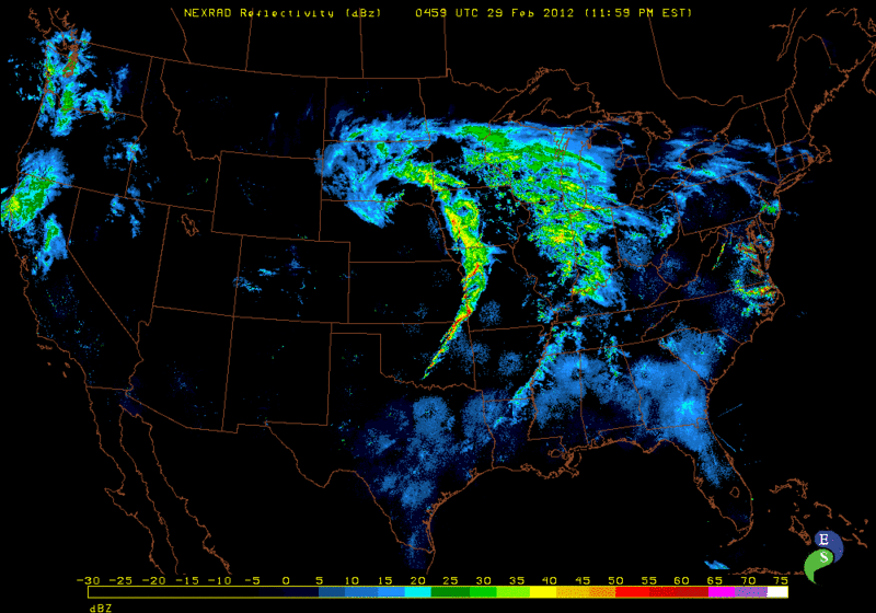
Een stuk of 9 tornadoreports momenteel en de lijn van cellen trekt nog steeds door over Missouri & Arkansas. Zodoende zal ook vandaag weer een pittige dag worden in Amerika. Dit keer 5 a 10% kans op tornado's in onderstaand gebied:
Tornado foto van een spotter in Nebraska:
Schade in Harveyville, KS

Tornado foto van een spotter in Nebraska:

Schade in Harveyville, KS

quote:Significant tornado damage in Harveyville, Kansas
A tornado reportedly caused significant damage to homes and several injuries in Harveyville, Kan., about 30 miles southwest of Topeka.
The small Wabaunsee County town of about 230 residents was hit about 9 p.m. as a severe storm system swept across central Kansas.
The Topeka Capital Journal website reported at midnight that there were nine injuries. One person was in critical condition and eight others suffered minor injuries.
Dave Sterbenz, Shawnee County’s director of emergency management, said the person in critical condition was still trapped within a structure.
Severe weather also struck in Missouri, with 70 mph winds reported in Clay County at 10:43 p.m. and pea-to-nickel-sized hail across the area. Two mobile homes reportedly were blown over along with downed power lines, trapping two people, in Daviess County in northwestern Missouri. A 30-foot-by-50-foot barn reportedly was blown over in DeKalb County.
Bill Gargan, a meteorologist with the National Weather Service, said his office couldn’t confirm late Tuesday whether a tornado hit Harveyville. He said a survey team would be sent out in the morning to investigate.
“We’ve heard there’s substantial structural damage,” Gargan said of the town’s homes and buildings.
Early Thursday it was reported that Gov. Sam Brownback had issued a disaster declaration for the area.
The Kansas Department of Transportation said Kansas Highway 195 was closed through and on either side of Harveyville until further notice. Kansas Highway 31 was also closed for a half-mile on each side of the city.


quote:tornado struck just after 9 pm
Emergency crews are on the scene in Harveyville, KS where the National Weather Service confirms a tornado struck the town just after 9:00pm
One person has been critically hurt, and several minor injuries were reported. A number of homes were damaged along with a church, and there are numerous reports of trees down and power lines down throughout the area.
Wabaunsee County Emergency Management says four individuals had been trapped in a structure for a time.
Law enforcement officials confirm everyone has been accounted for in the area.
One person had to be flown by air ambulance to a Topeka hospital.
A shelter has been set up at the high school for those displaced by the storm.
The governor’s declaration activates the disaster response and recovery portions of the Kansas Response Plan, authorizing state resources to expedite emergency assistance statewide, as necessary.
According to the Kansas Department of Transportation at approximately 10:00 p.m. K-195 was closed through and on either side of the city.
Also, K-31 is closed for a half-mile on either side of the city of Harveyville until further notice.
Drivers need to avoid area and use alternate routes until further notice. We will let you know when the roadway is reopened to all traffic.
[ Bericht 3% gewijzigd door Frutsel op 29-02-2012 10:11:29 ]