WKN Weer, Klimaat en Natuurrampen
Lees alles over het onstuimige weer op onze planeet, volg orkanen en tornado's, zie hoe vulkanen uitbarsten en hoe Moeder Aarde beeft bij een aardbeving. Alles over de verwoestende kracht van onze planeet en tal van andere natuurverschijnselen.


Anthony is wat in kracht afgenomen en lijkt de status van orkaan niet te gaan halen.
quote:Existing Cyclones in the Eastern Region:
Tropical Cyclone Anthony is moving east southeast over the central Coral Sea.
Likelihood of Tropical Cyclone Anthony remaining as a cyclone in the Eastern
Region on:
Tuesday: Moderate
Wednesday: Moderate
Thursday: Moderate

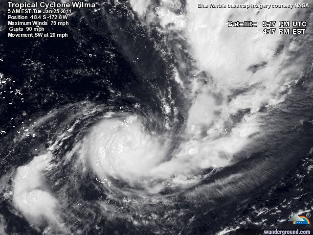
quote:Wilma has hit American Samoa
Tropical Cyclone Wilma has hit American Samoa and triggered alerts in other island countries in the central South Pacific, Radio New Zealand International reported on Monday.
American Samoa's Emergency Center said the Category 1 storm has winds of up to 110 km/h and gusts in excess of 130 km/h.
The storm has hit eastern villages, downing power lines, and is due to sweep over the western island of Tutuila.
So far there have been some landslides and debris on the road reported, as well as minor damage to some roofs and houses.
A marine warning said there was a hazardous surf up to 5 meters high throughout the storm, causing some flooding.
Pago Pago International Airport is still closed and it's not clear when inter island flights can resume.
American Samoa Governor, Togiola Tulafono, has activated the Emergency Operations Center, bringing together ten government agencies for a coordinated response.
As the cyclone heads south, it will also affect Samoa's main island, Upolu.
An alert is also in place for Tonga's northern islands.
For Tokelau, an alert is still in force, but winds there are expected to ease.
Bij West Australie lijkt ook een systeem te ontstaan.
[ Bericht 6% gewijzigd door #ANONIEM op 24-01-2011 19:11:25 ]

quote:A Tropical Cyclone Advice [IDW24100] is current for a developing tropical low.
At 8am WST Monday a tropical low was located over the north Kimberley near
latitude 14.7S longitude 127.1E, about 65 kilometres southeast of Kalumburu,
moving west at 16 kilometres per hour. Please refer to the latest Advice. The
low is expected to move in a generally westwards direction and be in the Western
region [west of 125E] just off the Kimberley coast on Tuesday. During the week
the low is expected to move towards the southwest parallel to the Pilbara coast.
The low may develop into a tropical cyclone late on Tuesday or more likely on
Wednesday.
Likelihood of this system being a tropical cyclone in the Western Region:
Tuesday :Moderate
Wednesday :High
Thursday :High
[ Bericht 6% gewijzigd door #ANONIEM op 24-01-2011 19:11:25 ]
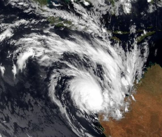
Accuweatherquote:Tropical Cyclone Brings Heavy Rain to Western Australia
A tropical cyclone will continue to affect northwestern Australia over the next few days. The cyclone formed Sunday over the Timor Sea and quickly moved inland across the Kimberley area of Western Australia. It is expected to reemerge offshore, gain strength, and brush much of the northern coast of Western Australia over the next few days.
Heavy rainfall has affected areas along the track of the cyclone. Kalumburu had 6.42 inches Monday, and Theda had nearly 7 inches.
The cyclone is maintaining good organization despite being over land. It will emerge back into the Indian Ocean early Tuesday, local time. It should quickly gain tropical storm strength, then parallel the Kimberley coast through Wednesday. Tropical storm conditions are most likely in the communities of Beagle Bay, Cape Leveque, and Kuri Bay. Tropical storm conditions are possible in the towns of Port Hedland and Exmouth Wednesday and Thursday.
Port Hedland is Australia's busiest port. It serves as an export point for iron ore, and other minerals mined across Western Australia. However, Port Hedland should not suffer a direct hit by the cyclone.
Fortunately, Western Australia has been spared the devastating flooding that has affected much of the rest of the country.
Tropische Cycloon Wilma met een windsnelheid van 120 km/uur ( waarmee het een categorie 1 wordt) en windstoten tot 144 km/uur, op weg naar de Tonga eilanden
Met een windsnelheid van 168 km/uur en windstoten tot 201 km/uur trekt Wilma als een cat 2 zuidwaarts richting Nieuw Zeeland. In de buurt van Nieuw Zeeland zal de cycloon in kracht afnemen tot tropische storm. (watertemperatuur is hier rond de 22 graden).
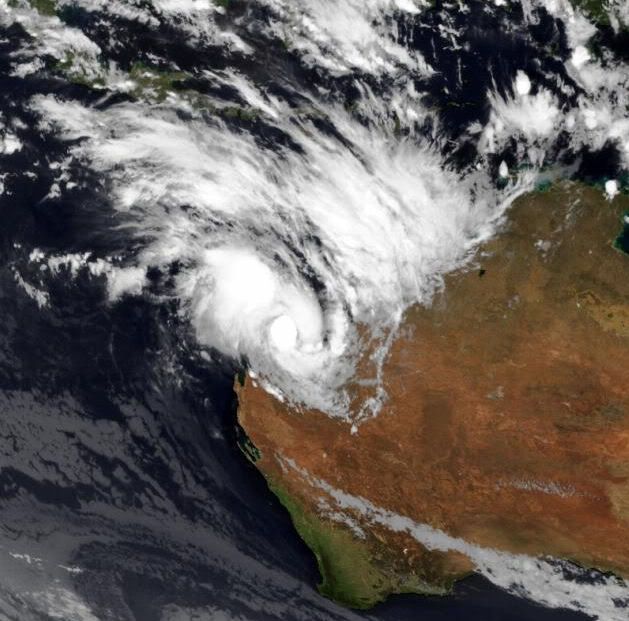
Bianca heeft een windsnelheid van 104 km/uur met windstoten tot 128 km/uur. Bianca trekt langs de westkust van Australie en zal (nu nog tropische storm) in kracht toenemen tot categorie 1 en daarna categorie 2
Bianca heeft een windsnelheid van 104 km/uur met windstoten tot 128 km/uur. Bianca trekt langs de westkust van Australie en zal (nu nog tropische storm) in kracht toenemen tot categorie 1 en daarna categorie 2

Wilma is inmiddels opgewaardeerd naar een categorie 4
Windsnelheid van 209 km/uur met windstoten tot257 km/uur
[ Bericht 14% gewijzigd door #ANONIEM op 26-01-2011 09:41:52 ]
Windsnelheid van 209 km/uur met windstoten tot257 km/uur
[ Bericht 14% gewijzigd door #ANONIEM op 26-01-2011 09:41:52 ]

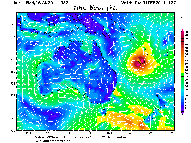
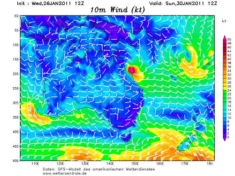
Kaartje voor 1 februari.
Weer een cycloon voor Nieuw Caledonie? (en misschien voor Australie)
[ Bericht 7% gewijzigd door #ANONIEM op 26-01-2011 15:07:20 ]
Weer een cycloon voor Nieuw Caledonie? (en misschien voor Australie)
[ Bericht 7% gewijzigd door #ANONIEM op 26-01-2011 15:07:20 ]
quote:Tropical Cyclone activity heats up near Australia
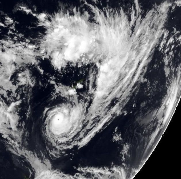
The year's first Category 4 tropical cyclone is Tropical Cyclone Wilma, which is churning the waters near Tonga in the Southern Hemisphere with sustained winds of 135 mph (minimum Category 4 strength.) Wilma passed over American Samoa as a strong tropical storm, and hit Tonga as a Category 3 storm. Substantial damage has been reported on Tonga, but no deaths or injuries. Wilma is recurving out to sea, and will not affect Australia.
Australia is keeping an eye on Tropical Cylone Bianca, which is expected to skirt the northwest coast of the country over the next few days. Of much greater concern for Australia are two potential tropical cyclones that could hit the flood-ravaged state of Queensland next week. Both the European Center and GFS models predict that the remains of Tropical Cyclone Anthony will regenerate into a tropical storm late this week and hit Queensland early next week. A second and potentially more powerful storm is forecast to form next week in the islands to the east of Australia, and threaten Queensland at the end of the week. This is potentially terrible news for Australia, which is attempting to recover from record floods. As reported in the latest Bureau of Meteorology climate statement and flood summary, the past four months (September - December) have been the rainiest such period in Queensland's history, and the resulting flooding disaster has been Australia's most expensive natural disaster in history.
Het lijkt er inderdaad op dat Anthony weer tot leven komt en zo'n beetje hetzelfde gebied in trekt waar de vorige tropische storm (Tasha) voor het begin van de overstromingen zorgde. En volgende week nadert waarschijnlijk nog een cycloon.quote:
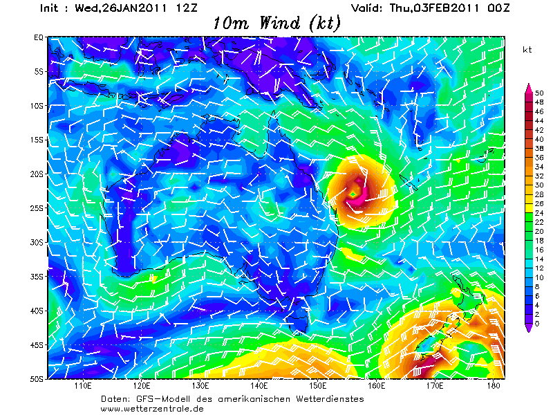
restanten anthony kaartje 30 januari
cycloon voor volgende week 3 februari
Met een windsnelheid van boven de 120 km/uur en windstoten tot 144 km/uur is Bianca een categorie 1 cycloon geworden en trekt langs de Westkust van Australie.
Bianca
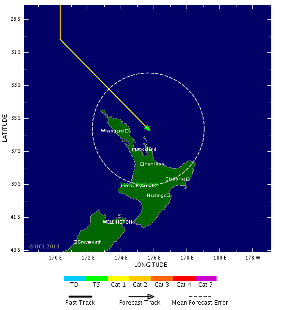
Wilma is met een windsnelheid van 185 km/uur en windstoten van 233 km/uur op weg naar Nieuw Zeeland. Wilma is nu een categorie 3 en zal afzwakken tot Tropische storm, als het Nieuw Zeeland bereikt.
Wilma
Bianca
Wilma is met een windsnelheid van 185 km/uur en windstoten van 233 km/uur op weg naar Nieuw Zeeland. Wilma is nu een categorie 3 en zal afzwakken tot Tropische storm, als het Nieuw Zeeland bereikt.
Wilma
De restanten van Anthony kunnen zich weer ontwikkelen in een tropische cycloon
quote:SITUATION
At 0600 UTC Ex-Tropical Cyclone Anthony was centred within 15 nautical miles of
latitude seventeen decimal four south (17.4S)
longitude one hundred and fifty four decimal eight east (154.8E)
Recent movement : west northwest at 9 knots
Maximum winds : 35 knots
Central pressure: 998 hPa
Ex-Tropical Cyclone Anthony may redevelop into a tropical cyclone during the
next 6 to 18 hours.
quote:Cyclone Wilma to rock north
Parts of the upper North Island are in for a gusty weekend with exceptionally strong winds and possible flooding forecast as a cyclone moves past the country.
Tropical Cyclone Wilma is near New Caledonia and is due here late tomorrow night, the MetService says.
"It should sideswipe the northeastern parts of Northland on Saturday morning, then get pushed off to the southeast and sideswipe Gisborne on Sunday evening. Then it will move way off to the east of us," said MetService weather ambassador Bob McDavitt.
The MetService has issued severe rain warnings for Auckland, eastern Waikato, Coromandel Peninsula, Bay of Plenty and Gisborne for tomorrow morning, saying slips or flooding are possible.
The heaviest rainfall is expected in Northland where 150mm to 200mm may fall within 24 hours. Mr McDavitt said the rain would be accompanied by gales.
"The cyclone has very tight isobars around it which makes the winds very strong."
Weather Watch chief analyst Philip Duncan said the upper North Island might have flooding similar to last Sunday's.
"Because it's a tropical storm it has very, very heavy rain which is not too good for the long weekend. And the winds will be gale force further north which is exceptionally strong ...
"But the good news is that when the winds pick up you know the rain's about to stop."
He said the cyclone would not affect the temperature and he has forecast between 24C and 26C for most of the upper North Island.
"The humidity may increase a little bit, but it won't get as bad as we've had recently."
Mr Duncan said the severe wind and rain would move off the country quickly with the promise of clear weather on Sunday and Monday.
"It's a quite a fast-moving weather system."


Bianca is inmiddels een categorie 4 en trekt langs de westkust van Australie. Windsnelheid is nu 209 km/uur met windstoten tot 257 km/uur.
Het lijkt er op dat Bianca als tropische storm landfall zal maken in het zuidwesten van Australie, in de buurt van Perth.
Het lijkt er op dat Bianca als tropische storm landfall zal maken in het zuidwesten van Australie, in de buurt van Perth.
De verwachting is dat Anthony zal terugkeren als cycloon en aan land zal gaan in het Noorden van Queensland. Bij de fiji eilanden ontwikkeld zich een nieuw systeem wat komende donderdag voor overlast kan gaan zorgen in Queensland.
quote:Cyclones menace WA, north Queensland
Emergency services are keeping a close eye on three cyclones approaching the coasts of North Queensland and Western Australia's south-west respectively.
Tropical Cyclone Anthony has reformed into a category one system off North Queensland and has turned back towards land.
The weather bureau says the cyclone reformed this morning and is about 950 kilometres north-north-east of Townsville.
Forecaster Greg Connor says it is likely to cross the coast between Cooktown and Mackay sometime early Monday morning.
"We do expect it to intensify. It's probable that it will get to category one or two, but there is the possibility it will get to category three before it gets to the coast," he said.
"The big danger with Anthony is that it's starting to move now towards the coast and we're likely to be putting out a cyclone watch for the coastal listening area for this evening from 5:00pm onwards."
Another system is off Fiji and could hit Queensland as a category four or five cyclone as early as next Thursday.
This system potentially poses the bigger threat to Queensland.
Premier Anna Bligh says she has reactivated the state's disaster management group to deal with the threat.
Ms Bligh also says the associated rain could bring more flooding.
And authorities along the south-west coast of Western Australia are preparing for possible damage from Cyclone Bianca.
The bureau says there is a significant risk that Bianca, a category three system, could maintain tropical cyclone intensity as it approaches the coast early on Sunday.
Forecasters have issued a cyclone watch for areas including Perth, Bunbury and Busselton. The cyclone passed Exmouth overnight, bringing strong winds but no reports of damage.
Wild weather
Bureau regional director Mike Bergin says although Bianca is expected to weaken to a category one system overnight, there will likely be very wild weather on Sunday.
"[There will be] damaging wind gusts to 120 kilometres per hour, so that will see severe to extreme fire danger with the northerly winds," he said.
"We'll be seeing very rough seas, increasing swells, significant wave heights probably up towards four metres. We'll probably see beach erosion as well."
The United States Navy website suggests the cyclone will cross the coast very close to Perth.
Fire and Emergency Services spokesman Allen Gale says the cyclonic activity will bring a mixture of problems.
"One of the big effects is the fire danger weather on Sunday - that will be a very significant, possibly up to a catastrophic [level warning]," he said.
Mr Bergin describes the cyclone as an "evolving story" and says people in the area should keep informed.
"Bianca still has a considerable distance to travel, better than 1,500 kilometres across the Indian Ocean," he said.
"So the uncertainties in the time of arrival are significant but the risk is very high."
The bureau has also warned low-lying coastal areas may be flooded.
But it says Bianca is not expected to be as bad as Cyclone Alby which hit Perth in 1978.
Alby claimed five lives and caused widespread damage in the Perth metropolitan area.
Earlier today a red alert was lifted for Exmouth and Coral Bay as the cyclone headed away from the coast.
Queensland Deputy Police Commissioner Ian Stewart says residents in the danger zone need to be prepared.
"I'd be asking people to think about stocking up on essential items, but there is no need for panic buying," he said.
"Make sure they have fuel in their vehicles, items in their yards and around their houses that could become missiles are put away or tied down."
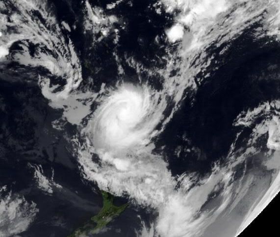
Het noorden van Nieuw Zeeland mag zich gaan opmaken voor de restanten van cycloon Wilma. Vooral de regen zal het grootste probleem gaan worden.
quote:Rough night ahead for North Islanders
Much of the North Island is in for a night of strong winds and heavy rain as the tail of a cyclone passes over.
And there are severe weather warnings in place.
The low causing the conditions used to be known as tropical cyclone Wilma. It has weakened on its way here, so it is no longer a cyclone. But it is still bringing plenty of rain down across Northland, through Auckland, Waikato and the Bay of Plenty, and out to the East Coast.
Northland has already been getting drenched since this afternoon, and with the ground up there already wet, the heavy rain is bound to cause flooding, although conditions should ease by the morning.
There is also a strong wind warning for eastern areas.
The torrential rain and strong winds are going to carry on throughout the night in Northland, Auckland and in the central and eastern North Island.
Many areas are looking at getting at least 100 millimetres of rain overnight.
These conditions can cause flooding and wind damage, and will certainly make driving conditions dangerous.
Most of the rain should have cleared by tomorrow afternoon, but if the forecasts are correct, there's likely to be a bit of mopping up to do over the weekend.
Ja in Auckland vanmorgen al meer dan 100mm en komt meer aan, had er nog een stukje over geschrevenquote:Op vrijdag 28 januari 2011 11:51 schreef aloa het volgende:
Het noorden van Nieuw Zeeland mag zich gaan opmaken voor de restanten van cycloon Wilma. Vooral de regen zal het grootste probleem gaan worden.
[..]
Weer of geen weer, altijd actueel www.onweer-online.nl
quote:Op vrijdag 28 januari 2011 12:02 schreef meteo-online het volgende:
[..]
Ja in noorden vanmorgen al 100mm, zijn ook meldingen gedaan vanuit Aukland en komt meer aan, had er nog een stukje over geschreven


Weer of geen weer, altijd actueel www.onweer-online.nl

Ik heb het net gelezen.quote:
[..]
Ja in Auckland vanmorgen al meer dan 100mm en komt meer aan, had er nog een stukje over geschreven
Er wordt nog zo'n 80 - 150 mm verwacht.
quote:Wilma is expected to be reclassified as an Ex-Tropical Cyclone as it passes by northern New Zealand overnight, but will still bring strong winds and heavy rain to northern parts of the North Island.
Another 80 to 150mm of rain is likely in these areas on top of what has already fallen, with rainfall rates possibly reaching 25 to 40mm per hour for a time.
Rainfalls of this intensity can cause surface and/or flash flooding,
lead to slips and will cause rivers and streams to rise quickly, says MetService.