WKN Weer, Klimaat en Natuurrampen
Lees alles over het onstuimige weer op onze planeet, volg orkanen en tornado's, zie hoe vulkanen uitbarsten en hoe Moeder Aarde beeft bij een aardbeving. Alles over de verwoestende kracht van onze planeet en tal van andere natuurverschijnselen.


Het is nog niet helemaal duidelijk wat Vince gaat doen.
[ Bericht 22% gewijzigd door #ANONIEM op 12-01-2011 19:00:37 ]
[ Bericht 22% gewijzigd door #ANONIEM op 12-01-2011 19:00:37 ]
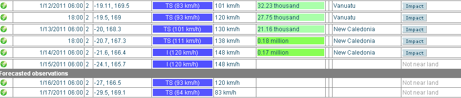
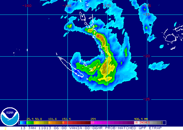
Vanuatu en Nieuw-Caledonië krijgen het flink te verduren. Vania gaat nog in kracht toenemen. De meeste neerslag zit nu boven Vanuatu (eilanden met als hoofdstad Port Vila (29.356 inwoners))
De cycloon trekt nu richting Nieuw-Caledonië (227.436 inwoners)
De cycloon trekt nu richting Nieuw-Caledonië (227.436 inwoners)

Eh, is de definitie van "een bovengemiddeld orkaanseizoen" dat de USA vaak getroffen dient te worden? Lijkt me niet.quote:Op donderdag 6 januari 2011 18:55 schreef Frutsel het volgende:
Interessant... voor 2010 werd een boven gemiddeld orkaanseizoen voorspeld... toch leek dat eigenlijk niet zo, want de US werd zo goed als niet getroffen, maar toch waren er aardig wat stormen.
Dat de USA afgelopen jaar niet vaak geraakt is komt door heersende windstromingen en niet doordat er weinig orkanen of stormen waren, imho.
NOAA noemt 2010 zelfs een extreem druk Atlantisch orkaanseizoen...
Daarom zeg ik ook "het leek van niet"... want we hebben er niet veel over gehoord in de media, juist omdat er nauwelijks landfall was.quote:
[..]
Eh, is de definitie van "een bovengemiddeld orkaanseizoen" dat de USA vaak getroffen dient te worden? Lijkt me niet.
Dat de USA afgelopen jaar niet vaak geraakt is komt door heersende windstromingen en niet doordat er weinig orkanen of stormen waren, imho.
NOAA noemt 2010 zelfs een extreem druk Atlantisch orkaanseizoen...
Daarbij komt dat er wel bovengemiddelde verwachtingen waren, dus ook voor eventuele landfall in de VS of de Carribean.
Tropical Cyclones in Indian, South Pacific Oceans
Two tropical cyclones are churning the tropical waters of the Southern Hemisphere as of Wednesday.
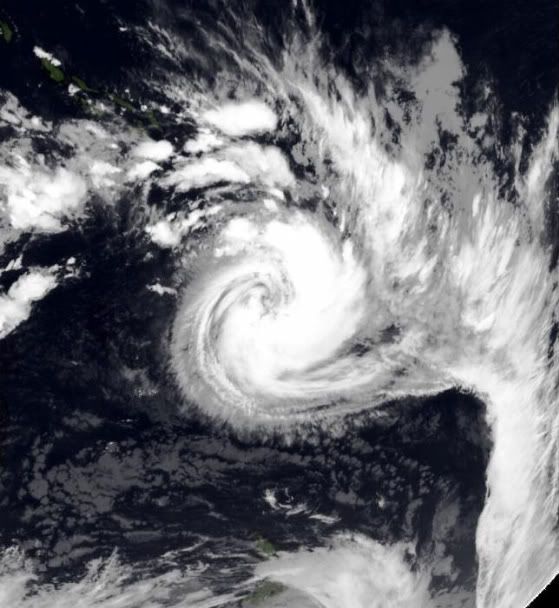
Tropical Cyclone Vania has spun up near the South Pacific island nation of Vanuatu. The center was within 125 miles, or 200 km, of Port-Vila, Vanuatu.
Having highest sustained winds of 50 mph, Vania was nearly stationary with a sluggish drift towards the southwest.
Cyclone Vania on Jan. 12, 2011. (Navy Research Lab Monterey).
Vania's greatest threat, rather than Vanuatu, is to the island of New Caledonia, which it could strike directly with hurricane gusts and flooding rain as early as Friday.
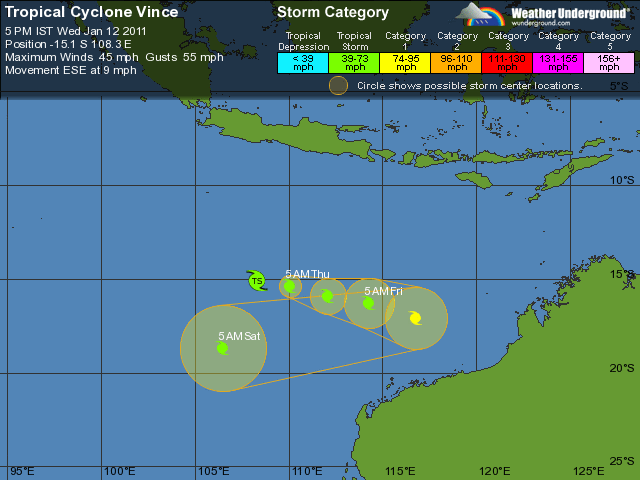
Meanwhile, far to the west, Tropical Cyclone Vince whirls over open seas well off northwestern Australia.
The location of Vince is about 750 miles, or 1200 km, west-northwest of Port Hedland, Australia.
Cyclone Vince on Jan 12, 2011 (Navy Research Lab Monterey).
Vince holds highest sustained winds of 45 mph, and the storm is tracking a little south of east at 8 mph.
Warm waters will help to promote strengthening of this tropical cyclone as it heads towards the east through Friday. Thereafter, movement is less certain and could shift substantially.
Much of the northwest coast of Australia is sparsely settled. However, there are important mineral loadings sites and off-shore petroleum production sites that could be adversely affected by a tropical cyclone.
Bron: Accuweather
[ Bericht 1% gewijzigd door #ANONIEM op 12-01-2011 22:16:01 ]
Two tropical cyclones are churning the tropical waters of the Southern Hemisphere as of Wednesday.
Tropical Cyclone Vania has spun up near the South Pacific island nation of Vanuatu. The center was within 125 miles, or 200 km, of Port-Vila, Vanuatu.
Having highest sustained winds of 50 mph, Vania was nearly stationary with a sluggish drift towards the southwest.

Cyclone Vania on Jan. 12, 2011. (Navy Research Lab Monterey).
Vania's greatest threat, rather than Vanuatu, is to the island of New Caledonia, which it could strike directly with hurricane gusts and flooding rain as early as Friday.
Meanwhile, far to the west, Tropical Cyclone Vince whirls over open seas well off northwestern Australia.
The location of Vince is about 750 miles, or 1200 km, west-northwest of Port Hedland, Australia.

Cyclone Vince on Jan 12, 2011 (Navy Research Lab Monterey).
Vince holds highest sustained winds of 45 mph, and the storm is tracking a little south of east at 8 mph.
Warm waters will help to promote strengthening of this tropical cyclone as it heads towards the east through Friday. Thereafter, movement is less certain and could shift substantially.
Much of the northwest coast of Australia is sparsely settled. However, there are important mineral loadings sites and off-shore petroleum production sites that could be adversely affected by a tropical cyclone.
Bron: Accuweather
[ Bericht 1% gewijzigd door #ANONIEM op 12-01-2011 22:16:01 ]
quote:New Caledonia on cyclone alert
New Caledonia's Loyalty Islands were on maximum alert for Cyclone Vania after it brought gale-force winds to Vanuatu.
The New Caledonian domestic airline grounded all flights until further notice.
The category 2 storm damaged food crops and small buildings in Vanuatu.
The weather bureau said it received widespread reports of low-level damage but communication with some islands, including Tanna, was cut after a phone tower was blown over.
New Caledonian officials say it could bring winds of up to 110 kilometres an hour to the Loyalty Islands and to the main island later.
Low-lying areas have been evacuated, businesses and schools are closed, and residents have been warned to take shelter and avoid coastal areas.
Ten oosten van Australie is ook weer een tropische depressie aktief

quote:SITUATION
At 1200 UTC a Tropical Low was centred within 60 nautical miles of
latitude thirteen decimal five south (13.5S)
longitude one hundred and forty nine decimal six east (149.6E)
Recent movement : north northwest at 6 knots
Maximum winds : 30 knots
Central pressure: 997 hPa
The low may develop into a tropical cyclone during the next 24 hours.
AREA AFFECTED
Within 60 nautical miles of the centre.
FORECAST
Clockwise winds 15/25 knots, increasing to 25/35 knots over the northern half.
Very rough seas developing.
Forecast positions
At 0000 UTC 14 January: Within 150 nautical miles of 13.2 south 150.8 east
Central pressure 995 hPa.
Winds to 35 knots near centre.
At 1200 UTC 14 January: Within 180 nautical miles of 14.4 south 152.1 east
Central pressure 989 hPa.
Winds to 40 knots near centre.
Vania is nog een tropische storm met een windsnelheid van 109 km/uur.
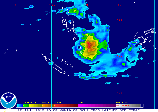
Neerslag komt op sommige plaatsen boven de 150 mm
Neerslag komt op sommige plaatsen boven de 150 mm
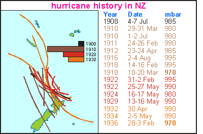
Orkanen over Nieuw Zeeland, "Gebeurd zoiets wel eens?" vroeg ik me af. En toen vond ik dit artikel uit 1892.
En een historisch lijstje (interessante link trouwens):
Maar goed, er kan nog zoveel gebeuren voordat die storm/orkaan daar is.
En een historisch lijstje (interessante link trouwens):
Maar goed, er kan nog zoveel gebeuren voordat die storm/orkaan daar is.
Ik verwacht geen orkaan voor Nieuw Zeeland. Dat ligt veel te zuidelijk. Zal waarschijnlijk bij een tropische storm/depressie blijven. Wat natuurlijk ook voor veel overlast kan gaan zorgen.
Op weg naar Nieuw Zeeland. Watertemperatuur ligt hier net onder de 22 graden.
Nieuw Caledonie komt ook weer dicht in de buurt voor deze cycloon.
[ Bericht 14% gewijzigd door #ANONIEM op 14-01-2011 19:16:09 ]
Nieuw Caledonie komt ook weer dicht in de buurt voor deze cycloon.

[ Bericht 14% gewijzigd door #ANONIEM op 14-01-2011 19:16:09 ]
Zelia is nu een categorie2 orkaan met een windsnelheid van 168 km/uur en windstoten tot 201 km/uur. Dinsdag nadert deze Nieuw Zeeland. Zelia zal dan afgezwakt zijn tot tropische storm.
ABC Newsquote:Norfolk Island spared cyclone's wrath
Norfolk Island has been spared the full force of Tropical Cyclone Zelia, which is now moving to the east of the island.
Earlier, it was predicted to move directly across the island but it is currently about 60 kilometres to the north-east and is rapidly moving further off shore.
The weather bureau says it has been downgraded to a category two cyclone and is unlikely to cause any significant damage.
The bureau says winds could reach gale force in the next few hours and seas could rise up to seven metres.


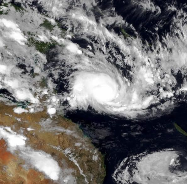
Anthony gaat rechtsomkeer maken en lijkt (volgens GFS) over een aantal dagen aan land te gaan in het noorden van Queensland. Wat voor nieuwe overstromingen kan gaan zorgen.
Wilma ligt nu boven de Samoa eilanden en zal koers zetten richting de Tonga eilanden.
[ Bericht 9% gewijzigd door #ANONIEM op 23-01-2011 14:08:54 ]

Wilma ligt nu boven de Samoa eilanden en zal koers zetten richting de Tonga eilanden.

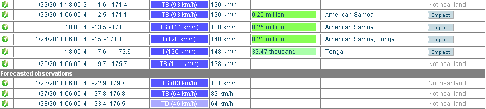
[ Bericht 9% gewijzigd door #ANONIEM op 23-01-2011 14:08:54 ]
quote:Existing Cyclones in the Eastern Region:
Tropical Cyclone Anthony is moving east in the northern Coral Sea and slowly
strengthening. Likelihood of TC Anthony remaining a tropical cyclone in Eastern
Region on:
Monday: High
Tuesday: High
Wednesday: High
quote:Potential Cyclones:
At 8am WST a tropical low was located just off the Kimberley coast near latitude
14.3S longitude 128.8E, about 75 kilometres west of Port Keats, moving north at
6 kilometres per hour. The low is expected to move in a generally westwards
direction and be in the Western region [west of 125E] just off the Kimberley
coast on Tuesday. During the week the low is expected to move towards the
southwest parallel to the Pilbara coast. The low may develop into a tropical
cyclone late on Tuesday or more likely on Wednesday.
Likelihood of this system being a tropical cyclone in the Western Region:
Monday :Low
Tuesday :Moderate
Wednesday :High
[ Bericht 52% gewijzigd door #ANONIEM op 23-01-2011 16:02:35 ]
en volgens dat plaatje wordt het wel iets meer dan een Cat 1quote:Op zondag 23 januari 2011 13:31 schreef aloa het volgende:
Anthony gaat rechtsomkeer maken en lijkt (volgens GFS) over een aantal dagen aan land te gaan in het noorden van Queensland. Wat voor nieuwe overstromingen kan gaan zorgen.
[ afbeelding ]
Wilma ligt nu boven de Samoa eilanden en zal koers zetten richting de Tonga eilanden.
[ afbeelding ]
[ afbeelding ]

