WKN Weer, Klimaat en Natuurrampen
Lees alles over het onstuimige weer op onze planeet, volg orkanen en tornado's, zie hoe vulkanen uitbarsten en hoe Moeder Aarde beeft bij een aardbeving. Alles over de verwoestende kracht van onze planeet en tal van andere natuurverschijnselen.


Interresant leesvoer over de Yellowstone vulkaan

rest van het artikelquote:ScienceDaily (Dec. 14, 2009) — The most detailed seismic images yet published of the plumbing that feeds the Yellowstone supervolcano shows a plume of hot and molten rock rising at an angle from the northwest at a depth of at least 410 miles, contradicting claims that there is no deep plume, only shallow hot rock moving like slowly boiling soup.
Inorbit: zeg dat dan typluie triangeljosti
Beauregard: Een beetje FOK!ker laat het brood door z'n moeder smeren.
Ecosia
ek's 'n flash drive, jy's 'n floppy
Beauregard: Een beetje FOK!ker laat het brood door z'n moeder smeren.
Ecosia
ek's 'n flash drive, jy's 'n floppy
Hier staat een linkje naar de videoquote:Molten lave from underwater volcano captured on video
More than three-quarters of volcanic eruptions happen underwater. But no one has seen molten lava flowing from a deep-ocean seafloor volcano — until now.
A team of scientists set out on an expedition, from Samoa, in early May to study an erupting volcano. Within an hour of reaching the West Mata volcano, the team saw smoke
"And then, wow! There it was. Red lava," said Joe Resing, a University of Washington oceanographer and chief scientist on the expedition. "Everybody. Went. Nuts."
It was 4,000 feet below the surface. The eruptions create new ocean floor.
Video of the eruption, which was recorded earlier this year, was released Thursday during the American Geophysical Union meeting in San Francisco.
The video shows red magma bursting in 35-foot streams from the volcano, turning black as it cooled, and rock fragments being thrown 150 to 300 feet.
Had such an eruption occurred on dry land, without the water pressure to keep it contained, lava and debris would have reached much farther.
The recording was made with a remote-controlled vehicle that could get within eight feet of the eruption site, something that's not possible on land.
"Something seemingly as plain as day, a process you'd expect we would have seen over and over again through the course of history, we've seen for the first time: lava flowing on the ocean floor, lava making new ocean crust," Resing said.
Other scientists, seeing telltale signs of volcanic activity, have chased possible eruptions around the seas. Often, the volcano explodes before they arrive.
Only one other seafloor volcanic eruption has ever been seen; that one sent debris and gases streaming into the ocean, but not lava, according to the University of Washington.
Resing hopes that seeing eruptions under the sea will help scientists understand eruptions that occur on land.


quote:Drie aardbevingen, waaronder een met een kracht van 4,6 op de schaal van Richter, zijn zaterdag rond de vulkaan Etna op het eiland Sicilië geregistreerd.
De eerste twee aardbevingen met een kracht van 2,7 en 4,3 op de schaal van Richter bij de Etna vonden zaterdag 's ochtends vroeg plaats. In de voormiddag volgde dan de derde en zwaarste aardbeving (4,6 op de richterschaal).
De epicentra van de bevingen liggen in drie verschillende zones van de vulkaan op zo'n zestien tot 22 kilometer diepte. Van schade zou er geen sprake zijn.
er drukt gewoon 1200 bar op die vulkaan en toch komt de lava er zo uit knallen..quote:Op vrijdag 18 december 2009 09:04 schreef Frutsel het volgende:
[..]
Hier staat een linkje naar de video
impressive...
Inorbit: zeg dat dan typluie triangeljosti
Beauregard: Een beetje FOK!ker laat het brood door z'n moeder smeren.
Ecosia
ek's 'n flash drive, jy's 'n floppy
Beauregard: Een beetje FOK!ker laat het brood door z'n moeder smeren.
Ecosia
ek's 'n flash drive, jy's 'n floppy
quote:Vulkaan Piton de la Fournaise uitgebarsten
Op het eiland La Réunion in de Indische oceaan is de vulkaan Piton de la Fournaise uitgebarsten. In de krater Dolomieu werden vandaag lavastromen en aardverschuivingen waargenomen. Boven de krater hangt een gas- en aswolk. Toeristen en eilandbewoners wordt verboden om de top van de krater te bezoeken.
De Piton de la Fournaise op het eiland Réunion, een Frans overzees departement, is één van de actiefste vulkanen op aarde. Uitbarstingen komen doorgaans twee tot drie keer per jaar voor. Ook op 14 december spuwde de vulkaan nog een grote lavamassa uit.


quote:Vulkaan Nyamulagira barst uit
In Oost-Congo is de vulkaan Nyamulagira uitgebarsten. De lavastroom die daardoor op gang gebracht werd, bedreigt het nationale Virungapark. Daar leven zeldzame chimpansees en berggorilla's. Dat melden regeringsfunctionarissen. De habitat van de chimpansees wordt bedreigd door de lava.
Het bedreigde gebied is een deel van het Virunga National Park, waar zo'n veertig chimpansees en tweehonderd berggorilla's leven. Wat de gorilla's betreft is dat meer dan een kwart van de totale populatie op de hele wereld. Er zou geen rechtstreeks gevaar zijn voor de berggorilla's.

quote:8000 mensen geevacueerd na nieuwe uitbarsting Galeras Colombia
De Colombiaanse vulkaan Galeras is uitgebarsten. Niemand raakte gewond door de uitbarsting, maar de overheid gelastte wel de evacuatie van ruim achtduizend mensen.
De Galeras ligt in het Andesgebergte in het zuiden van Colombia nabij de grens met Equador. De vulkaan barstte in 2009 al tien keer uit. De autoriteiten waarschuwen dat de spuwende berg voorlopig nog onrustig zal blijven.
Gewend
De mensen die rond de vulkaan wonen zijn gewend geraakt aan de vele alarmeringen en evacuaties.
Ontruimingen verlopen dan ook altijd soepel, hoewel een deel van de bevolking weigert mee te werken aan de door de overheid opgelegde maatregel.

Nyamuragira is echt begonnen:
quote:Nyamuragira Volcano, Democratic Republic of Congo - John Seach
Posted by John Seach
An eruption began at Nyamuragira volcano on 2nd January 2010 at 4:58 am local time. Lava flowed 500 m from a fissure on the southeast flank of the volcano towards the Virunga National Park
be nice or go away

http://www.hln.be/hln/nl/(...)Rica-barst-uit.dhtml
quote:Vulkaan Turrialba in Costa Rica barst uit
De vulkaan Turrialba in Costa Rica, komt tot uitbarsting. De naburige bevolking is overgegaan tot de evacuatie. Dat meldt het observatorium voor vulkanologie van Costa Rica. De 3.340 meter hoge vulkaan ligt 40 km ten oosten van San Jose en kende zijn laatste uitbarsting in 1866, maar is altijd als actief beschouwd. (belga/kh)
Op zaterdag 15 augustus 2009 23:05 schreef eer-ik het volgende:
Ik vind je sig nogal denigrerend.
Ik vind je sig nogal denigrerend.

Dat vind ik ook, vandaar dat ik er maar wat aandacht aan heb geschonken.quote:
'Vulkanen zijn wereldwijd onrustig'
Op zaterdag 15 augustus 2009 23:05 schreef eer-ik het volgende:
Ik vind je sig nogal denigrerend.
Ik vind je sig nogal denigrerend.
Goeie zaakquote:Op woensdag 6 januari 2010 15:35 schreef OA het volgende:
[..]
Dat vind ik ook, vandaar dat ik er maar wat aandacht aan heb geschonken.
'Vulkanen zijn wereldwijd onrustig'
O, dat was wel de bedoeling...quote:Op woensdag 6 januari 2010 15:46 schreef Frutsel het volgende:
[..]
Goeie zaakJe had La Reunion ook nog mee kunnen pikken
Straks nog even toevoegen.
Op zaterdag 15 augustus 2009 23:05 schreef eer-ik het volgende:
Ik vind je sig nogal denigrerend.
Ik vind je sig nogal denigrerend.

Ziet er nu al super uit johquote:
[..]
O, dat was wel de bedoeling...
Straks nog even toevoegen.
Leuk, een heus item op de FP.quote:Op woensdag 6 januari 2010 15:58 schreef OA het volgende:
[..]
O, dat was wel de bedoeling...
Straks nog even toevoegen.
be nice or go away
Zolang ze maar niet allemaal tegelijk uitbarsten, vind ik het wel een mooi gezicht 
Dare to unleash my rage..
That's my secret Captain... I'm always angry...
There's nothing like a trail of blood, to find your way back home.
That's my secret Captain... I'm always angry...
There's nothing like a trail of blood, to find your way back home.
Is ook een mooie berg trouwens:quote:Op woensdag 6 januari 2010 13:52 schreef OA het volgende:
http://www.hln.be/hln/nl/(...)Rica-barst-uit.dhtml
[..]


Wiki

Weer een stratovolcano trouwens.quote:Turrialba Volcano was named after the region of Costa Rica in which the volcano is situated in Turrialba County, Cartago of Costa Rica. There is no clear consensus on the origin of the name Turrialba, but historians disagree with attempts to attribute the name to the patronym Torrealba (from Aragon in Spain) or from the Latin Turris alba (white tower). The general consensus is that Turrialba derives from a local Indian language (Huetar) but there is no agreement on its actual roots.
The stratovolcano is 3,340 m (10,958 ft) high and is about 45 minutes from the Atlantic slope town of Turrialba. The summit has three craters, one of which has fumaroles and sulfur pits. Visitors used to be able to hike down into the main crater, but increased gaseous activity has caused the time at the summit to be limited to no more than fifteen minutes. The hike to the top from where the vans usually are forced to stop takes about one to three hours depending on the ability of the hikers. Below the summit is a mountain range and cloud forest, with ferns, bromeliads, lichens and mosses. During the 19th century, it explosively erupted several times (1847?, 1853, 1855, 1861?, 1864-1865, 1866), producing pyroclastic flows. The last major eruption was in 1856, but in January 2001, the volcano reported increased activity, displaying strong fumaroles at the central craters. In January 2010, the valcano emitted ash, and two villages were evacuated.[1]
Turrialba is adjacent to Irazú and both are among Costa Rica's largest volcanoes. It had at least five large explosive eruptions in last 3500 years.
The three craters of the volcano, the oldest one is to right, the newest and most active is to the left

En ver van bewoond gebied gelukkig, als er dan toch 1 moet ploffen, dan deze maar.
[ Bericht 3% gewijzigd door kahaarin op 06-01-2010 18:45:06 ]
be nice or go away
Tungurahua ook bezig? Nog niets van gehoord, behalve op FOK 
Edit: Check:
[ Bericht 81% gewijzigd door ScudRaket op 06-01-2010 20:26:39 ]
Edit: Check:
quote:TUNGURAHUA REGISTRA ACTIVIDAD "ASCENDENTE"
QUITO, 5 (ANSA)- El volcán Tungurahua, ubicado en la frontera entre la provincia homónima y la de Chimborazo, en el centro de Ecuador, registró un nivel "ascendente" de actividad con emisiones incandescentes que afectan a las poblaciones cercanas, informó hoy el Instituto Geofísico (IG).
"La actividad del volcán se mantiene aún en un nivel considerado como bajo pero con una tendencia de comportamiento ascendente", indicó el Instituto Geofísico en su reporte. La fuente agregó que "se han recibido reportes de la presencia constante de columnas de emisión de humo con moderado a nulo contenido de ceniza, expulsión de material incandescente en forma de bloques y fuentes de lava".
El IG confirmó que el lunes se registró una columna de ceniza de 2 kilómetros de altura y en la noche se registró emisión de material incandescente, con actividad constante. La caída de ceniza afecta a las poblaciones cercanas de Bilbao, Manzano, Cahuají, Chogluntus y Putzupala, que se dedican al cultivo de cebolla, maíz y papa.
El volcán Tungurahua, de 5.029 metros de altitud y ubicado a unos 135 kilómetros al sur de Quito, tuvo en noviembre de 1999 una fase de reactivación que derivó en la evacuación de las poblaciones vecinas. JMG
[ Bericht 81% gewijzigd door ScudRaket op 06-01-2010 20:26:39 ]
If it has a grass wicket, play cricket! (Nee, dit slaat niet op het spelletje!)
Lullo scrotum ejaculatio est.
Hattrick: Ladderzatsquad (208243)
Lullo scrotum ejaculatio est.
Hattrick: Ladderzatsquad (208243)
Netjes.quote:
[..]
Dat vind ik ook, vandaar dat ik er maar wat aandacht aan heb geschonken.
'Vulkanen zijn wereldwijd onrustig'
nog meer vulkanen?
Monteserat
Monteserat

quote:In the waning days of 2009 and the first days of 2010, the lava dome on the summit of Soufrière Hills Volcano continued to grow rapidly. As the dome rises, rocks and debris can break off, cascading down the river valleys and gullies that radiate from the summit. These pyroclastic flows are among the major hazards created by Soufrière Hills.
Inorbit: zeg dat dan typluie triangeljosti
Beauregard: Een beetje FOK!ker laat het brood door z'n moeder smeren.
Ecosia
ek's 'n flash drive, jy's 'n floppy
Beauregard: Een beetje FOK!ker laat het brood door z'n moeder smeren.
Ecosia
ek's 'n flash drive, jy's 'n floppy
volcano live news
Nyamuragira volcano in the Democratic Republic of the Congo last erupted in November 2006 and is classed as one of the world’s most active, erupting every few years.
quote:Thursday, January 07, 2010
Nyamuragira Volcano, Democratic Republic of Congo - John Seach
Posted by John Seach
The eruption continues at Nyamuragira volcano in the Democratic Republic of Congo. After 4 days lava has traveled 21 kilometers, and is only 7 kilometers from the Goma-Sake road. Four craters were active at the beginning of the eruption. The lava flows are still within the boundaries of Virunga National Park. Volcanologists from Goma said lava could reach the Goma-Sake road within 2 to 3 days. Chimpanzees of Tongo have not been harmed.

Nyamuragira volcano in the Democratic Republic of the Congo last erupted in November 2006 and is classed as one of the world’s most active, erupting every few years.
be nice or go away
KILAUEA VOLCANO (CAVW #1302-01-)
19°25'16" N 155°17'13" W, Summit Elevation 4091 ft (1247 m)
Current Aviation Color Code: ORANGE
Current Volcano Alert Level: WATCH
Activity Summary for past 24 hours: Kilauea continues to erupt from two vents. At the summit, sloshing, circulating lava was visible via webcam at the bottom of a deep pit inset within the floor of Halema`uma`u Crater and its glow was visible from Jaggar Overlook overnight. Lava from the east rift zone vents made another attempt down the tube system again yesterday evening. Sulfur dioxide emission rates from both vents probably remain elevated.
Was deze ook al gemeld hier?
Dare to unleash my rage..
That's my secret Captain... I'm always angry...
There's nothing like a trail of blood, to find your way back home.
That's my secret Captain... I'm always angry...
There's nothing like a trail of blood, to find your way back home.
Deze is toch alrijd actief? Met af en toe een soort van hikje?quote:Op zaterdag 9 januari 2010 10:56 schreef Burner82 het volgende:
KILAUEA VOLCANO (CAVW #1302-01-)
19°25'16" N 155°17'13" W, Summit Elevation 4091 ft (1247 m)
Current Aviation Color Code: ORANGE
Current Volcano Alert Level: WATCH
Activity Summary for past 24 hours: Kilauea continues to erupt from two vents. At the summit, sloshing, circulating lava was visible via webcam at the bottom of a deep pit inset within the floor of Halema`uma`u Crater and its glow was visible from Jaggar Overlook overnight. Lava from the east rift zone vents made another attempt down the tube system again yesterday evening. Sulfur dioxide emission rates from both vents probably remain elevated.
Was deze ook al gemeld hier?
quote:Monday, January 11, 2010
Soufriere Hills Volcano, Montserrat - John Seach
Posted by John Seach
Large pyroclastic flows occurred at Soufriere Hills volcano at 2:49 pm on 8th January 2010. The pyroclastic flows were caused by a collapsing tephra column, similar to the events in the summer of 1997. The flows traveled northeast down Whites Bottom Ghaut and reached the sea. The flow which moved down Tuitts Ghaut stopped a few hundred metres from the sea. Pyroclastic flows also traveled northwest down Tyers Ghaut and into the Belham valley. The event lasted 11 minutes and was not preceded by seismic activity. Ashfall occurred on the northwestern side of the volcano. Residents said it was one of the largest eruptions they have witnessed at the volcano, since its reawakening in 1995. At 1:28 am on 10th January there was another explosion at the volcano. The seismic signal lasted 7 minutes. The eruption produced pyroclastic flows which traveled rapidly northeast down White Bottom and Tuitts Ghaut. Flows also moved northwest down Tyers Ghaut and down the Gages valley towards Plymouth. A third smaller explosion occurred at 8:27 pm on 10th January. Scientists don't believe there was a major collapse of the dome, but a significant amount of material was lost. Hazard level 4 remains in place around the volcano, which means there is no access allowed in zone C, and only daytime access to zone B
wiki
quote:The Soufrière Hills volcano (French "Sulphur" Hills) is an active complex stratovolcano with many lava domes forming its summit on the Caribbean island of Montserrat. After a long period of dormancy, it became active in 1995, and has continued to erupt ever since. Its eruptions have rendered more than half of Montserrat uninhabitable, destroying the capital city, Plymouth, and causing widespread evacuations: about two thirds of the population left the island. Seismic activity had occurred in 1897–1898, 1933–1937, and again in 1966–1967, but the eruption that began on July 18, 1995, was the first since the 17th century.[2] When pyroclastic flows and mudflows began occurring regularly, Plymouth was evacuated, and a few weeks later a pyroclastic flow covered the city in several metres of debris.

2009 ash and steam plume, Soufriere Hills Volcano. Gray deposits that include pyroclastic flows and volcanic mudflows (lahars) are visible extending from the volcano toward the coastline. NASA ISS photo
be nice or go away
quote:Crack At Turrialbla Volcano Getting Larger, Experts Say
Upon closer inspection, experts of the Universidad de Costa Rica (UCR) say that the enormous crater of the Turrialba volcano has gotten larger following last week's activity, which will in turn cause landslides within the crater, which in turn could mean more eruptions.
Unfortunately the cold front that has gripped Costa Rica this weekend has also affected the weather conditions, rain and strong winds, have been clouding visibility of the crater to confirm all the changes.
Geologists and volcanologists were at least able to confirm that the crack on the wall of the volcano is getting larger, confirmed by flybys by helicopters during a break in the weather.
The experts say the constant spewing of gases is causing the crack to get bigger and could collapse the volcano's crater wall, causing the volcano to spew out the falling material.
Area residents, as well as control posts around the volcano, report feeling seismic activity.
The recommendation is to stay clear of the area and authorities are restricting access to the national park, evacuating anyone found within the safety zone

quote:Large pyroclastic flows from Montserrat's Soufriere Hills Volcano
BRADES, Montserrat (GIU) -- Scientists at the Montserrat Volcano Observatory (MVO) confirmed there was a large pyroclastic flow forming event occurred at Soufriere Hills volcano on Friday afternoon around 2:49pm.
The island came to a temporary standstill as everyone took in the sight of the massive ash cloud that exploded but amazingly did not send much ash and no ballistic material into inhabited areas. Several residents remarked that they had not seen an ash cloud that broad since the early days of the volcano’s reawakening in the mid 1990s.
This afternoon’s event Dr Paul Cole, MVO Director confirmed was similar to the summer 1997 explosion. “A collapsing fountain of tephra, associated with ballistic fragments, was observed at the start of the event on the northeastern side of the volcano. We do not believe that there was major collapse of the dome but significant amount of material was lost.”
Cloud cover around the top of the volcano is inhibiting visibility and scientists are not able to tell if the dome which has been growing rapidly since December has diminished considerably.
According to the MVO statement on the event, “Large pyroclastic flows moved both to the northeast, down towards the old airport, to the northwest down Tyers Ghaut, and into the Belham Valley these flows reached as far as approximately 300 m upstream of the Belham crossing. Pyroclastic flows also moved to the west towards Plymouth, although it is presently unclear whether they actually reached the sea. The event lasted about 11 minutes and seismicity returned to background levels rapidly.”
The Hazard Level is 4. There is no access to Zone C and only daytime access (6:30 am to 5:30 pm) to Zone B.
quote:Nyamuragira Volcano, Democratic Republic of Congo
Eruptions continue at Nyamuragira volcano in the Democratic Republic of Congo. Lava could cover the Goma and Sake road within weeks. Ash and gas emissions from the volcano have caused health problems for residents. Drinking water from open springs and rainwater catchments in Sake, Kingi and Rusayo have been contaminated by ash. Health centres at Sake and Rusayo have reported increasing cases of diarrhoea, and eye diseases. People around the volcano have reported death of domestic animals and damage to crops. It is estimated that 52,096 people are affected, including: 7,901 from Mugunga (Mumbabiro), 13, 000 from Rusayo and 31,195 from Sake & Kingi localities.

quote:Volcano-like eruptions in Arunachal
TANAGAR: In a very rare phenomenon on Indian soil, volcano-like eruptions have triggered large-scale forest fires that are threatening vast tracts
There is no official word on these "eruptions" that have occurred in the last few days in the Dehu Mountain range in Kurung Kumey district.
Sources from the remote area said a forest fire has broken out at nearby Langa Tata Mountain situated in between Yangte and Chambang. Arunachal West MP Takam Sanjay has requested CM Dorjee Khandu to seek help from the Geological Survey of India, Department of Mines and Minerals and Forests to investigate into the phenomenon.
In August 2007, similar eruptions had disturbed residents near Kimin in Lower Subansiri district, in which coal-like substances were detected after the remains had cooled down. While scientists from GSI and the Arunachal government's geology and mining department collected evidence, they didn't confirm presence of lava.
Local authorities claimed the fires then were caused by electric short-circuit that generated enough heat to
melt stones around a 200sq metre area.
quote:Inferno may be a volcano???
Itanagar: The forest of Kurung Kumi district at Chambang in Arunachal Pradesh has been facing a massive inferno for past few days. The fire has engulphed the entire forest and created panic among people in the area as they are discussing of having volcano instead of fire.
According to the Geological Survey of India (GSI), there are only three active volcanoes in the country and they all located in Anadaman & Nicobar Island which is too far from Arunachal Pradesh as the authority has also denied of having any such reports.
Similar incident of fire occurred erstwhile in the region but the facts were against of having any volcano. The fire has perturbed the Member of Parliament, Sanjay Takam, who asked the Chief Minister Doorjee Khandu to enquire the incident and take necessary initiative in this regard.

Bizar
Zo is een deel van india ontstaan, uit een (basalt? magma, shit hoe heet die troep) bel die langzaam naar boven kwam.
Dacht ik ook ergens te hebben gelezen
Dacht ik ook ergens te hebben gelezen
Inorbit: zeg dat dan typluie triangeljosti
Beauregard: Een beetje FOK!ker laat het brood door z'n moeder smeren.
Ecosia
ek's 'n flash drive, jy's 'n floppy
Beauregard: Een beetje FOK!ker laat het brood door z'n moeder smeren.
Ecosia
ek's 'n flash drive, jy's 'n floppy

Filmpje uitbarstingquote:Underwater volcano blows top
An underwater volcano erupted Wednesday morning about 5 kilometers north-northwest of Iwo Jima (Iwo To), sending a plume of white ash and steam into the air.
The eruption of the Fukutokuoka no Ba undersea volcano -- which last erupted in July 2005 -- was discovered at about 7:45 a.m. by a Japan Coast Guard patrol boat. According to the coast guard, the volcano is about 1,300 kilometers south of Tokyo, and has also erupted in 1904, 1914 and 1986. In each case small islands were formed, all of which, however, eventually sank back into the ocean.
Since around the 1950s, the sea in the area has regularly changed color, and turned yellow-green last December
Gezellig, een moddervulkaan in je achtertuin 

Rest van het artikelquote:On May 29, 2006, hot mud began to pour from the ground near a gas exploration well, covering fields and villages in the Sidoarjo region of East Java, Indonesia. Despite efforts to staunch the flow, the mud kept coming, forming the world’s largest and fastest growing mud volcano. By the time the Advanced Spaceborne Thermal Emission and Reflection Radiometer (ASTER) on NASA’s Terra satellite captured this false-color image on October 20, 2009, the erupting mud truly resembled a volcano.
Inorbit: zeg dat dan typluie triangeljosti
Beauregard: Een beetje FOK!ker laat het brood door z'n moeder smeren.
Ecosia
ek's 'n flash drive, jy's 'n floppy
Beauregard: Een beetje FOK!ker laat het brood door z'n moeder smeren.
Ecosia
ek's 'n flash drive, jy's 'n floppy
quote:Volcano erupts on Caribbean island
A volcano on the tiny Caribbean island of Montserrat has shot a plume of ash an estimated nine miles into the sky, one of its most dramatic events since a devastating 1997 eruption that drove away half the population.
The partial collapse of the dome over the volcano's crater also unleashed flows of hot gas and rocks, triggering sirens for the evacuation of about 20 people from a nearby village.
Paul Cole, director of the Montserrat Volcano Observatory, said it appeared to be the most material shed by the volcano in about four years.
The dome has crumbled several times since the volcano became active in 1995, and Mr Cole said it is possible that activity would settle down now as the dome builds itself up again.
He said there was no immediate cause for concern about more dangerous activity.
Als ik zo vrij mag zijn:quote:
Gezellig, een moddervulkaan in je achtertuin
[ afbeelding ]
[..]
Rest van het artikel
Sidoarjo mudflow
mijn smily was misplaatst, het is een ramp idd...quote:Op zaterdag 13 februari 2010 00:20 schreef indahnesia.com het volgende:
[..]
Als ik zo vrij mag zijn:
Sidoarjo mudflow
Inorbit: zeg dat dan typluie triangeljosti
Beauregard: Een beetje FOK!ker laat het brood door z'n moeder smeren.
Ecosia
ek's 'n flash drive, jy's 'n floppy
Beauregard: Een beetje FOK!ker laat het brood door z'n moeder smeren.
Ecosia
ek's 'n flash drive, jy's 'n floppy
Dit is in 2007 en 2008 ook gebeurd. Kennelijk is het niet geheel duidelijk wat voor iets het is.. Ook handig..quote:Op dinsdag 2 februari 2010 15:50 schreef Frutsel het volgende:
[..]
[..]
[ afbeelding ]
Bizarzou wat zijn als daar een vulkaan onder de grond zit
http://www.google.co.id/search?hl=en&rlz=1B3GGGL_nlNL328NL328&q=Arunachal+volcano&btnG=Search&meta=&aq=f&oq=
Man heeft het niet overleefdquote:Wandelaar valt in actieve vulkaan
WASHINGTON - Een Amerikaanse wandelaar is in de krater van de actieve vulkaan Mount Saint Helens gestort in de noordwestelijke staat Washington.
Hulpdiensten zetten een flinke reddingsactie op touw en wisten tot op zo'n 15 meter van het slachtoffer te komen, maar ze konden hem toch niet helpen.
De 52-jarige man wilde zich maandag bij de krater laten fotograferen, toen het sneeuwdek ineens inzakte.

quote:Sakurajima volcano in southern Japan erupted more than 400 times during 2009, and activity is increasing in early 2010. The Advanced Land Imager (ALI) aboard NASA’s Earth Observing-1 (EO-1) satellite captured this natural-color image of the erupting volcano on February 15, 2010. Gray ash is visible in the plume that extends northeast (towards the lower-right) of the volcano. Ashfall is a regular occurence at the daikon and mandarin farms surrounding the volcano, as well as the nearby cities of Kagoshima and Kirishima.
ah, weer een mooi plaatje

Bronquote:Neighboring volcanoes on Russia’s Kamchatka Peninsula acted up at the same time in mid-February 2010. Klyuchevskaya Volcano in the north and Bezymianny Volcano in the south both sent plumes skyward over a snowy landscape. The Advanced Spaceborne Thermal Emission and Reflection Radiometer (ASTER) on NASA’s Terra satellite captured this false-color image on February 13, 2010
Inorbit: zeg dat dan typluie triangeljosti
Beauregard: Een beetje FOK!ker laat het brood door z'n moeder smeren.
Ecosia
ek's 'n flash drive, jy's 'n floppy
Beauregard: Een beetje FOK!ker laat het brood door z'n moeder smeren.
Ecosia
ek's 'n flash drive, jy's 'n floppy
Volgende week de Tungurahua bekijken  Vrienden van me hebben al schitterende foto´s geschoten, hoop ze erna ook te hebben (en met jullie te delen natuurlijk).
If it has a grass wicket, play cricket! (Nee, dit slaat niet op het spelletje!)
Lullo scrotum ejaculatio est.
Hattrick: Ladderzatsquad (208243)
Lullo scrotum ejaculatio est.
Hattrick: Ladderzatsquad (208243)
quote:Eyjafjoll volcano, Iceland
An earthquake swarm began under Eyjafjoll volcano in January 2010. There was a 40 mm inflation of the volcano. At the beginning of March 2010 over 3000 earthquakes were measured in a 24 hour period, with a maximum at magnitude 3.1. The last eruptions at Eyjafjoll volcano were in 1821-23.
Geophysicist Sigurlaug Hjaltadóttir at the Icelandic Meteorological Office told ruv.is that the tremors last night were stronger than those measured yesterday morning. The series of quakes was similar in character and lasted for approximately one hour.
Magma flow seems to be at full speed inside the volcano and the series of earthquakes probably indicates a magma intrusion, Hjaltadóttir explained.
It is not known how volcanic eruptions begin in Eyjafjallajökull—it last erupted in 1821—and magma movements might continue for a few weeks.
The Civic Protection Department has not lifted the uncertainty stage, which was declared last week. The volcano will be monitored continuously.
========
Binnenkort BOEM op ijsland?

Hmm, zou zo maar kunnen, het is wel weer een mooie berg:quote:

Hier staat ook een filmpje van de vulkaan.
Het zit Ijsland niet mee, een bom onder Icesave en nu ook nog onder de voeten....
be nice or go away
wacht maar, de aarde is nog maar net aan het opwarmen door de gemuteerde nutrino's die door de zon worden uitgezondenquote:Op vrijdag 19 maart 2010 10:23 schreef Frutsel het volgende:
Zo druk als het begin dit jaar was... zo rustig lijkt het nu
TT niet waardig
Inorbit: zeg dat dan typluie triangeljosti
Beauregard: Een beetje FOK!ker laat het brood door z'n moeder smeren.
Ecosia
ek's 'n flash drive, jy's 'n floppy
Beauregard: Een beetje FOK!ker laat het brood door z'n moeder smeren.
Ecosia
ek's 'n flash drive, jy's 'n floppy

Be carefull what you wish for! * klopt op hout *quote:Op vrijdag 19 maart 2010 10:23 schreef Frutsel het volgende:
Zo druk als het begin dit jaar was... zo rustig lijkt het nu
TT niet waardig
be nice or go away
De laatste tijd waren aardbevingen even hipquote:
Zo druk als het begin dit jaar was... zo rustig lijkt het nu
TT niet waardig
DeLuna vindt me dik ;(
Op zondag 22 juni 2014 12:30 schreef 3rdRock het volgende:
pas als jullie gaan trouwen. nu ben je gewoon die Oom Rubber die met onze mama leuke dingen doet :)
Op zondag 22 juni 2014 12:30 schreef 3rdRock het volgende:
pas als jullie gaan trouwen. nu ben je gewoon die Oom Rubber die met onze mama leuke dingen doet :)
2012 een keer teveel gekeken?quote:Op vrijdag 19 maart 2010 10:41 schreef Jumparound het volgende:
[..]
wacht maar, de aarde is nog maar net aan het opwarmen door de gemuteerde nutrino's die door de zon worden uitgezonden
Dare to unleash my rage..
That's my secret Captain... I'm always angry...
There's nothing like a trail of blood, to find your way back home.
That's my secret Captain... I'm always angry...
There's nothing like a trail of blood, to find your way back home.
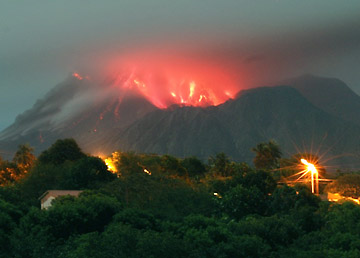
En het is begonnen:quote:Op woensdag 10 maart 2010 22:30 schreef Frutsel het volgende:
[..]
Geophysicist Sigurlaug Hjaltadóttir at the Icelandic Meteorological Office told ruv.is that the tremors last night were stronger than those measured yesterday morning. The series of quakes was similar in character and lasted for approximately one hour.
Magma flow seems to be at full speed inside the volcano and the series of earthquakes probably indicates a magma intrusion, Hjaltadóttir explained.
It is not known how volcanic eruptions begin in Eyjafjallajökull—it last erupted in 1821—and magma movements might continue for a few weeks.
The Civic Protection Department has not lifted the uncertainty stage, which was declared last week. The volcano will be monitored continuously.
========
Binnenkort BOEM op ijsland?
A volcanic eruption has just begun under the Eyjafjallajökull glacier. This has been verified by local authorities in neighbouring Hvolsvöllur. Vísir reports that farms in the Fljótshlíð area and by Markarhlíð are already being evacuated. Locals in the area have confirmed that they are viewing flames and a steady stream of lava from the glacier.
http://www.grapevine.is/N(...)der-Eyjafjallajokull
En op NU.nl staat het inmiddels ook
quote:Een vulkaan in het gebied van de gletsjer Eyjafallajoekull, bijna 120 kilometer ten zuidoosten van Reykjavik, is zondagmorgen actief geworden.