WKN Weer, Klimaat en Natuurrampen
Lees alles over het onstuimige weer op onze planeet, volg orkanen en tornado's, zie hoe vulkanen uitbarsten en hoe Moeder Aarde beeft bij een aardbeving. Alles over de verwoestende kracht van onze planeet en tal van andere natuurverschijnselen.


9 doden door tyfoon Wipha
(Novum/AP) - De tyfoon Wipha, die Taiwan en de oostkust van China trof, heeft aan negen mensen het leven gekost. In China werden 2,7 miljoen mensen geëvacueerd in verband met de storm die duizenden huizen verwoestte.
In de Chinese provincie Zhejiang kwamen vijf mensen om het leven doordat de storm aardverschuivingen veroorzaakte. In de provincie Jiangsu en Shanghai werden in totaal drie mensen geëlektrocuteerd. In Taiwan kwam een bouwvakker om het leven toen een steiger omver werd geblazen. Nog eens drie mensen worden vermist. Op veel plaatsen viel de stroom uit. De schade in China wordt voorlopig geschat op 4,8 miljard yuan (456 miljoen euro).


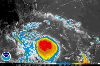
Super Typhoon Wipha
At one time a powerful Category 4 storm, Typhoon Nari made landfall on the southern coast of the Korean peninsula as a Category 2 storm on September 16, 2007. Less than three days later, Category 3 strength Typhoon Wipha made landfall on the east coast of China. It too was a once powerful Category 4 storm. Together these storms brought a significant amount of rainfall to the region. As of September 20, Nari had caused at least 13 deaths in South Korea, while Typhoon Wipha caused at least 9 deaths in China, said news reports.
This image shows rainfall totals associated with the two storms from September 13 through September 20. The path of the storms is defined by two parallel swaths of rainfall of at least 100 millimeters (about 4 inches, yellow areas) extending northward from the western Pacific Ocean towards the Korean Peninsula. The swath on the right is associated with the passage of Nari, while that on the left is due to Wipha. The highest totals over South Korea are on the order of 150 to 250 mm (about 6 to 10 inches) and come from both Typhoon Nari and its interaction with a pre-existing frontal boundary. Likewise, the highest totals associated with the passage of Wipha, located over Korea Bay and the northern Yellow Sea (areas in red indicating on the order of 200 mm or about 8 inches of rain), are from Wipha’s interaction with a frontal boundary.
These rainfall totals are from the near-real-time Multi-satellite Precipitation Analysis (MPA) at NASA Goddard Space Flight Center. The Multi-satellite Precipitation Analysis is based on measurements from the Tropical Rainfall Measuring Mission (TRMM) satellite, which came into service in November 1997 with the primary mission of measuring rainfall in the Tropics using a combination of passive microwave and active radar sensors. TRMM is a joint mission between NASA and the Japanese space agency, JAXA.


Wat een rare plek zegquote:
als die het een paar daagjes volhoudt gaat ie nog richting engeland
en Zuid Oost Azie krijgt weer regen, regen en nog eens regen

Rare plek ja, daar zie je ze niet vaak ontstaan.quote:Op zondag 23 september 2007 15:24 schreef Frutsel het volgende:
[..]
Wat een rare plek zeg
als die het een paar daagjes volhoudt gaat ie nog richting engeland
en Zuid Oost Azie krijgt weer regen, regen en nog eens regen
[afbeelding]
Het zal dan ook geen orkaan gaan worden.
AL11 is inmiddels Subtropische Storm Jerry geworden.
aardig wat systemen om in de gaten te houden.
[ Bericht 37% gewijzigd door Caesu op 23-09-2007 19:39:10 ]


aardig wat systemen om in de gaten te houden.
[ Bericht 37% gewijzigd door Caesu op 23-09-2007 19:39:10 ]
Dostojewski: "Je kunt je niet van je eigen gezond verstand overtuigen door je buurman op te sluiten."

Misschien dat jullie dit weten; maar het zit me al een tijdje dwars..
Wie geeft eigenlijk de naam aan een Tropical Depression/Tropical Storm?
Ik weet wel dat het jongen/meiden naam is, en op alfabetische volgorde, maar de namen zelf verbaast me.
Naja, ben benieuwd of iemand dit weet te beantwoorden.
Wie geeft eigenlijk de naam aan een Tropical Depression/Tropical Storm?
Ik weet wel dat het jongen/meiden naam is, en op alfabetische volgorde, maar de namen zelf verbaast me.
Naja, ben benieuwd of iemand dit weet te beantwoorden.
Die worden toch gegeven door de Hrruicane Prediction Centra of zoiets? Bv dat in Miami en waar die andere dan ook zitten (Japan of zo? ).
http://www.nhc.noaa.gov/retirednames.shtmlquote:The NHC/TPC does not control the naming of tropical storms. Instead, a list of names has been established by an international committee of the World Meteorological Organization. For Atlantic hurricanes, there is actually one list for each of six years. In other words, one list is repeated every seventh year. The only time that there is a change is if a storm is so deadly or costly that the future use of its name on a different storm would be inappropriate for obvious reasons of sensitivity. If that occurs, then at an annual meeting by the committee (called primarily to discuss many other issues) the offending name is stricken from the list and another name is selected to replace it.
There is an exception to the retirement rule, however. Before 1979, when the first permanent six-year storm name list began, some storm names were simply not used anymore. For example, in 1966, "Fern" was substituted for "Frieda," and no reason was cited.
http://www.wmo.ch/pages/index_en.html
Dostojewski: "Je kunt je niet van je eigen gezond verstand overtuigen door je buurman op te sluiten."
Tropische Storm Karen
kleine kans dat Karen hurricane wordt.
ze loopt de komende dagen stuk op windschering.
Tropische Storm Lorenzo
komt morgen aan land in Mexico.

kleine kans dat Karen hurricane wordt.
ze loopt de komende dagen stuk op windschering.
Tropische Storm Lorenzo

komt morgen aan land in Mexico.
Dostojewski: "Je kunt je niet van je eigen gezond verstand overtuigen door je buurman op te sluiten."
Tropical Storm LORENZO gaat voor flink wat neerslag zorgen.
Windsnelheid 60 mph en de snelheid waarmee de storm zich verplaatst is 3 mph. (vandaar ook de grote hoeveelheid neerslag tot 27 cm)
[ Bericht 26% gewijzigd door #ANONIEM op 27-09-2007 22:06:28 ]
Windsnelheid 60 mph en de snelheid waarmee de storm zich verplaatst is 3 mph. (vandaar ook de grote hoeveelheid neerslag tot 27 cm)
[ Bericht 26% gewijzigd door #ANONIEM op 27-09-2007 22:06:28 ]


Orkaan Lorenzo bedreigt Mexico
MEXICO-STAD - De Mexicaanse deelstaat Veracruz wordt bedreigd door orkaan Lorenzo. De autoriteiten hebben uit voorzorg 100.000 mensen geëvacueerd.
Kort voordat het natuurgeweld vanuit de Golf van Mexico aan land zou gaan, nam de windkracht fors toe en werd de tropische depressie een orkaan van de eerste categorie.
Volgens het Amerikaanse orkanencentrum zal Lorenzo zodra hij boven land is snel afzwakken. Behalve veel wind brengt Lorenzo ook veel regen met zich mee.
De regio Veracruz heeft de afgelopen tijd al heel wat te stellen gehad met zware regenval. Daardoor is de kans op overstromingen groot.
Op zaterdag 15 augustus 2009 23:05 schreef eer-ik het volgende:
Ik vind je sig nogal denigrerend.
Ik vind je sig nogal denigrerend.
Orkaan Lorenzo geselt Mexico
MEXICO-STAD - Orkaan Lorenzo heeft vrijdag dood en verderf gezaaid aan de Golfkust van Mexico. Volgens de autoriteiten in de deelstaat Veracruz vielen er zeker drie doden als gevolg van een overstroming nadat de orkaan aan land was gekomen. Uit voorzorg waren 100.000 mensen geëvacueerd. In 85.000 huizen viel de stroom uit.
Lorenzo was een orkaan van de laagste categorie en zwakte al rap af tot een tropische storm. Het was de derde orkaan in enkele weken tijd die Mexico aandeed. Meteorologen verwachten nog veel overlast van Lorenzo, vooral als gevolg van de hevige regenval die met de orkaan gepaard gaat.
telegraaf

Tropische Storm Melissa
Dostojewski: "Je kunt je niet van je eigen gezond verstand overtuigen door je buurman op te sluiten."
Ik wil volgend jaar de eerste 3 weken van november naar Florida. Hoeveel echte narigheid is er in die periode geweest de afgelopen 20 jaar, iemand data voor me?
quote:Op maandag 1 oktober 2007 13:45 schreef BretsiG het volgende:
Ik wil volgend jaar de eerste 3 weken van november naar Florida. Hoeveel echte narigheid is er in die periode geweest de afgelopen 20 jaar, iemand data voor me?
4 Orkanen die de VS troffen in november sinds 1900
http://www.usatoday.com/weather/huricane/whnovmajor.htm
Dus ik verwacht weinig tot geen problemen, hooguit een tropische storm met wat regenoverlast