WKN Weer, Klimaat en Natuurrampen
Lees alles over het onstuimige weer op onze planeet, volg orkanen en tornado's, zie hoe vulkanen uitbarsten en hoe Moeder Aarde beeft bij een aardbeving. Alles over de verwoestende kracht van onze planeet en tal van andere natuurverschijnselen.


Wordt steeds gekker
Doe mee met het voorspellen van het weer!
Weekvoorspelling | Week 41 (Inschrijven tot 6-10, 11:59)
Maandvoorspelling | September (Gesloten)
Jaarvoorspelling 2024 / 2025
Weekvoorspelling | Week 41 (Inschrijven tot 6-10, 11:59)
Maandvoorspelling | September (Gesloten)
Jaarvoorspelling 2024 / 2025
Een "grape" is een druif
"Pain is my friend. I can trust pain. I can trust pain to make my life utterly miserable."
"My brain is too smart for me."
"We don't need no education." "Yes you do, you just used a double negative."
"My brain is too smart for me."
"We don't need no education." "Yes you do, you just used a double negative."
ik kwam er net zelf ook achter toen ik het bericht opnieuw doorlasquote:Op donderdag 31 mei 2007 17:20 schreef wonderer het volgende:
Een "grape" is een druif
damn, toch nog iemand die het zag, voordat ik het zelf herstelde

Tornadoes strike northern Wisconsin
A series of tornadoes ripped through the Upper Midwest region of the United States in the evening of June 7, 2007. At least five different tornadoes touched down in Wisconsin, according to the Associated Press, one of which tore through the Bear Paw Resort in northern Wisconsin. Despite dropping as much as fifteen centimeters (six inches) of rain in some places and baseball-size hail in others, authorities were reporting no deaths attributable to the storm system, and only a smattering of injuries, but considerable property damage in some areas.
When the MODIS instrument on NASA’s Terra satellite observed the area on June 9, 2007, the track torn through the woods by one of the tornadoes stands out quite clearly. This photo-like image uses data collected by MODIS in the normal human vision range to give a familiar natural-looking appearance. The landscape is largely a checkerboard of farms, towns, roads, and cities. The pale land is predominantly farmland where crops have not fully grown in yet. Dark blue shows the winding path of rivers and lakes dotting the landscape. The large blue lake on the east (right) side of the image is Lake Michigan. Towns and cities, including the city of Green Bay, are gray. To the north side, farmland gives way to dark green as land use shifts from agriculture to the Menominee Indian Reservation and Nicolet National Forest. The diagonal slash through the dark green forested land shows the tornado track. Bare land was revealed where the tornado tore down trees or stripped vegetation off the branches.

Een spoor van meer dan 50 km zo te zien.quote:Op maandag 11 juni 2007 23:26 schreef Frutsel het volgende:
[afbeelding]
Tornadoes strike northern Wisconsin
A series of tornadoes ripped through the Upper Midwest region of the United States in the evening of June 7, 2007. At least five different tornadoes touched down in Wisconsin, according to the Associated Press, one of which tore through the Bear Paw Resort in northern Wisconsin. Despite dropping as much as fifteen centimeters (six inches) of rain in some places and baseball-size hail in others, authorities were reporting no deaths attributable to the storm system, and only a smattering of injuries, but considerable property damage in some areas.
When the MODIS instrument on NASA’s Terra satellite observed the area on June 9, 2007, the track torn through the woods by one of the tornadoes stands out quite clearly. This photo-like image uses data collected by MODIS in the normal human vision range to give a familiar natural-looking appearance. The landscape is largely a checkerboard of farms, towns, roads, and cities. The pale land is predominantly farmland where crops have not fully grown in yet. Dark blue shows the winding path of rivers and lakes dotting the landscape. The large blue lake on the east (right) side of the image is Lake Michigan. Towns and cities, including the city of Green Bay, are gray. To the north side, farmland gives way to dark green as land use shifts from agriculture to the Menominee Indian Reservation and Nicolet National Forest. The diagonal slash through the dark green forested land shows the tornado track. Bare land was revealed where the tornado tore down trees or stripped vegetation off the branches.
Daar staat geen boom meer overeind.
Er staat daar niet meer zoveel overeind
Zie de vele pics @ http://www.channel3000.com/slideshow/news/13469737/detail.html en http://www.channel3000.com/slideshow/news/13428507/detail.html (hagel zo groot als een baseball ) . Meer filmpjes en foto's @ http://www.channel3000.com/news/13464999/detail.html en http://news.google.nl/news?hl=en&ned=us&q=Bear+Paw+Resort+ .
Zie de vele pics @ http://www.channel3000.com/slideshow/news/13469737/detail.html en http://www.channel3000.com/slideshow/news/13428507/detail.html (hagel zo groot als een baseball ) . Meer filmpjes en foto's @ http://www.channel3000.com/news/13464999/detail.html en http://news.google.nl/news?hl=en&ned=us&q=Bear+Paw+Resort+ .
Hagelsteentjesquote:Op dinsdag 12 juni 2007 19:48 schreef Roel_Jewel het volgende:
Er staat daar niet meer zoveel overeind
Zie de vele pics @ http://www.channel3000.com/slideshow/news/13469737/detail.html en http://www.channel3000.com/slideshow/news/13428507/detail.html (hagel zo groot als een baseball ) . Meer filmpjes en foto's @ http://www.channel3000.com/news/13464999/detail.html en http://news.google.nl/news?hl=en&ned=us&q=Bear+Paw+Resort+ .


Hagel komt vaker voor in de VS.
quote:Records en historische feiten
Grootste (enkelvoudige) hagelsteen in Nederland:
waarschijnlijk 9 cm, 6 juni 1998 te Nunspeet (is nog officieus).
Grootste (enkelvoudige) hagelsteen op aarde:
15.2 cm doorsnede, 766 gram zwaar op 3 sept. 1970 in Coffeyville (Kansas, VS).
Meest getroffen gebied met hagel:
In Cheyenne (Wyoming) komen 9 tot 10 echte hagelstormen voor per jaar. Ook het noordwesten van Kansas en noorden van Colorado (VS) behoren tot de meest getroffen gebieden.
In El Dorado (Kansas) viel op 23 juni 1951 de hagel tot een dikte van 30 cm.
In Hyderabad (India) waren op 17 maart 1939 samengestelde stenen gevallen met een gewicht van ca. 3,5 kg.
In Kansas en Missouri viel 23 juni 1951 de hagel in een strook van ruim 300 km lang. Totale schade: meer dan 14 miljoen dollar (de meeste schade in de VS).
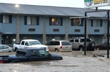
2 die as heavy rains bring flooding to Texas cities
HALTOM CITY, Texas (AP) -- Torrential overnight rainfall flooded a handful of north Texas towns Monday, killing two people and stranding residents and their pets on the roofs of their homes awaiting rescue.
Creeks swollen by as much as 8 inches of rain inundated parts of the towns of Gainesville and Sherman near the Oklahoma state line.
A 4-year-old girl, Alexandria Collins, was swept away to her death while firefighters were trying to rescue her and her mother from their home in Haltom City, a Fort Worth suburb. Her body was found more than two hours later.
"We were in the boat when the boat capsized," her mother, Natasha Collins, tearfully told KXAS-TV of Dallas. "The current swept her from my arms."
But firefighters said the girl was already missing by the time they pulled her mother onto a boat.
A woman died in Sherman, about 60 miles northwest of Dallas near the Oklahoma state line, after her car stalled in rising water and was swept away, Sherman police Sgt. Bruce Dawsey said. A firefighter was struck by lightning but went back to work helping with rescues, he said. Watch floodwaters flow through city
About 125 residents of a Sherman nursing home were being evacuated, and an unknown number of people were being rescued from an office building where the roof started caving in, Dawsey said.
In Gainesville, aerial video showed dozens of people seeking refuge from the high water on a railroad crossing. Families awaited rescue on their roofs, some having hacked their way to the outside from their attics. Some were joined by their dogs. Watch rescuers pull residents from rooftops
Water had receded from parts of downtown Gainesville by midday.
About 100 mobile homes in Haltom City were inundated and many were washed off their foundations, emergency officials said.
"When I looked out the window, water was up to the bottom of the window and the current was so fast houses were washing away, said Haltom City resident Rachel Hawkes. "You could hear people screaming but we couldn't get out to help."
About 37,000 people live in Sherman and about 16,500 in Gainesville.
Authorities closed Interstate 35 from Gainesville to the Oklahoma state line for several hours, the Texas Department of Public Safety said. Some other roads in the region also were closed by high water.
The National Weather Service said rain fell at a rate of an inch every 15 minutes in some places early Monday.
"We get heavy rains in North Texas, but the rate, the amount, the duration and the coverage of this are just amazing," said Gary Woodall, the warning-coordination meteorologist for the weather service office in Fort Worth.
The weather service forecast a chance of isolated thunderstorms in the area Monday and Tuesday but said overall the weather was expected to improve.

Floods in Texas and Oklahoma
Heavy rains pounded the Southern Plains of the United States during mid-June when moisture from the Gulf of Mexico streamed northward into a slow-moving frontal system. The result was extensive flooding over parts of Texas and Oklahoma. On Monday, June 18, 2007, six flood-related deaths were reported in northern Texas as storms dumped up to 8 inches (abut 200 millimeters) of rain in the area. On Tuesday, additional storms dumped heavy rains over parts of northwestern Oklahoma, forcing several road closures, said news reports.
This image shows rainfall totals for June 14 through June 20, 2007. The rainfall totals are from the, near-real time Multi-satellite Precipitation Analysis (MPA), which is based on measurements taken by the Tropical Rainfall Measuring Mission (TRMM) satellite. The MPA analysis indicates that during this time more than 200 mm (~8 inches, red area) of rain fell in northern Texas just south of the Oklahoma border, where flooding was reported. A much broader area of at least 150 to 200 mm (about 6 to 8 inches) of rain covers most of northwest Oklahoma. Based on these totals, the TRMM team predicted that flooding was likely or occurring. The group produces a global map indicating where there is a high potential for flooding based on rainfall totals.

More tornadoes hit southern Manitoba (Canada)
Environment Canada is looking into reports that more tornadoes swept through southern Manitoba, a day after fierce twisters caused heavy damage in the town of Elie, west of Winnipeg.
Twisters were spotted Saturday evening near Pipestone, Minto, the Canupawakpa First Nation and an area between Hartney and Deloraine.
Environment Canada officials inspect the damage in Elie on Saturday.
(John Woods/Canadian Press) Ross Tycoles, the reeve of Pipestone, about 100 kilometres southwest of Brandon, was playing baseball when the wild weather hit. He said there was unusual cloud cover.
"Everything was moving and turbulent, up and down. There was severe lightning north of the town," he said.
Tycoles heard reports of damaged barns, garages and farm equipment near Pipestone, but no injuries. One woman he spoke to told him she was terrified as a twister passed dangerously close to her house.
Some houses were damaged on the Canupawakpa First Nation, he said.
WATCH THE VIDEO ---> http://www.cnn.com/video/(...)oba.tornado.stringer
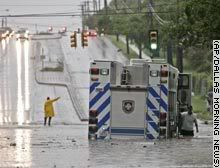
Downpour strands people on roofs, in trees
GEORGETOWN, Texas (AP) -- Torrential storms flooded parts of central Texas early Wednesday, stranding people on roofs, in trees and in vehicles, with wind-blown rain falling so hard that some helicopter rescue attempts had to be abandoned.
The worst flooding was in Williamson, Lampasas and Burnet counties in the Texas Hill Country northwest of Austin.
"We got hard facts of 18-plus inches of rain in a couple of those places since midnight," Austin-Travis County emergency medical services spokesman Warren Hassinger said just after 7 a.m.
More rain was expected throughout the day, the National Weather Service said.
Parts of Oklahoma also were soaked Wednesday, with rain falling on Oklahoma City for the 15th consecutive day, breaking a 70-year-old record. (Watch floodwaters swamp Oklahoma roads, fields )
Hassinger's agency had reports early Wednesday of at least 20 trapped atop vehicles, on roofs or clinging to trees surrounded by fast-moving water.
However, the weather was so stormy that helicopter crews had to abandon several rescue attempts, Hassinger said. He said four rescue attempts were halted before dawn and he didn't know what happened to the people needing help.
One aborted rescue mission had attempted to get four people from the roof of a house in Granite Shoals, where water was about 4 feet from the top of the building. They had pulled a possible drowning victim from the water, Hassinger said.
One successful helicopter-assisted rescue plucked a Williamson County sheriff's deputy and another person from atop the lawman's car along the San Gabriel River near Georgetown, Hassinger said. (Watch water pour down streets of Fort Worth )
Ray Thomas and his wife fled their house on a peninsula between the North and South San Gabriel rivers at about 4:45 a.m., after hearing an emergency weather radio bulletin.
"We're lucky we got out," he said. "In September we were praying for rain. What worries me now is the rain that's still to come."
Tuesday night, residents of at least 50 homes had to be evacuated from a flooded subdivision near Lake Granbury, about 60 miles southwest of Dallas. Rescuers used boats and jet skis to remove those residents as Robinson Creek rose out of its banks.
Speed of water's rise 'hard to believe'
About 30 evacuees spent Wednesday morning at the First United Methodist Church in Granbury, the Rev. Neil Norman said.
"There's some shock because the water must have come up extremely quickly," Norman said. "This is all pretty much hard to believe."
In Oklahoma, about 20 firefighters had to use a raft to rescue 16-year-old twin sisters from their car, stalled in rushing bumper-deep water Tuesday. (Watch terrified teens rescued from car )
The Oklahoma City area received about an inch of rain in 24 hours, bringing the city's annual total to 28.03 inches -- about 10 inches above normal. Flooding closed some roads Wednesday in central and northeastern Oklahoma.
"Anytime it rains there's going to be the threat of heavy downpours, it's not out of the question for any one area to get three inches," National Weather Service meteorologist Ty Judd said Wednesday in Norman, Oklahoma.
Boy dies after creek sweeps him away
A 13-year-old boy died in the Dallas suburb of Garland Tuesday night after being washed down a flooded creek, police spokesman Joe Harn said. The boy was swept away when firefighters using ropes tried to pull him ashore from a bridge pillar where he was stranded. He was found a mile downstream about two hours later, Harn said.
A number of flood warnings were posted throughout Texas. North Bosque River near Clifton was expected to crest at almost 29 feet early Wednesday, which is about 6 feet above normal.
Elsewhere, several Chicago streets and basements were flooded as parts of the city received 3 to 4 inches of rain in about 45 minutes, just before Tuesday's evening rush hour, according to the National Weather Service.
The water department received more than 700 reports of flooded basements, officials said.
Veel neerslag in Texas
Zware onweersbuien hebben in de nacht van dinsdag op woensdag veel neerslag bezorgd in Texas. De neerslag viel na een week met zware buien. In totaal zijn al 11 mensen om het leven gekomen door de overstromingen.
De meeste neerslag viel in Marble Falls, ongeveer 60 kilometer van Austin af. Hier werd 455,1 millimeter neerslag afgetapt in 24 uur tijd. Bruggen liepen schade op, huizen stroomden over en wegen waren onbegaanbaar. Ook was er plaatselijk veel wind. In het westen van Texas werden windstoten tot 160 kilometer per uur gemeten.
Eleven dead in Texas floods; more rain expected (CNN)
455,1 millimeter in 24uur

Floods in Texas and Oklahoma
June 2007 was exceptionally wet for the Southern Plains of the United States because a stagnant weather pattern focused moisture and storms over Texas and Oklahoma. The latest round of heavy storms dumped up to 460 millimeters (18 inches) of rain in parts of Central Texas on the night of Tuesday, June 26, said news reports. For Austin, the state's capital, more than 30 inches of rain has fallen since January, making 2007 the wettest year on record so far according to local news reports.
This image shows rainfall totals from the near-real time Multi-satellite Precipitation Analysis (MPA), which is based on rainfall data collected by the Tropical Rainfall Measuring Mission TRMM) satellite. The totals shown here indicate how much rain fell between June 20 and June 28, 2007. Splotches of red over central Texas and southern Oklahoma indicate where the MPA recorded up to 200 millimeters (8 inches) of rain. A broad area of at least 50 mm (~2 inches) of rain fall covers almost all of Texas and Oklahoma. These totals fall short of totals reported on the ground because the satellites used in the MPA can't see areas of localized heavy rain. These satellites zoom in to approximately 30 kilometers (20 miles), and so miss smaller areas of intense rain.
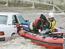
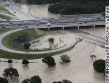
MARBLE FALLS, Texas — More rain fell Thursday in flood-weary parts of Texas, where evacuations were under way and residents were bracing for even more of the constant downpours that have killed 11 people in recent days.
Officials reported calls for dozens of rescues in San Antonio, and hundreds of people were being ordered to leave their homes near the bloated Brazos River in North Texas.
Lt. Gov. David Dewhurst, acting as governor while Gov. Rick Perry is out of the country, surveyed damage Thursday in the lakeside community of Marble Falls, which was drenched by as much as 18 inches of rain early Wednesday. No one was killed, but there were 32 water rescues and widespread damage.
"I haven't seen so much destruction since I was on the ground right after Hurricane Rita," Dewhurst said. "What these folks need is just a break in the rain and a chance to dry out."
In North Texas, rains continued falling west of Fort Worth, and evacuations of about 300 homes were ordered in Parker County as the Brazos River began creeping into some backyards.
Firefighters and National Guard troops went door to door notifying residents of the mandatory evacuation, but some refused to leave, said Lt. Jason Williams of the Parker County firefighters' search and rescue team.
Among those holding out was Donna Thorpe, who said she and her family had been watching the water rise for more than 24 hours and marking it with a measuring stick.
"Every two hours we'd get up and go down and measure," Thorpe said. "Every two hours you get up and go down. You really don't sleep. You're so nervous about it, how quick it can come up."
Overnight rainfall in Central Texas was far short of the 10 inches that were forecast, but more was expected Thursday, and flash flood warnings were in effect. Storm systems near Austin and San Antonio were expected to dump as much as 10 inches Thursday, the National Weather Service said.
Marble Falls, about 40 miles northwest of Austin, took the brunt of the deluge Tuesday and Wednesday, with numerous people stuck on rooftops, in trees and on houses. The city was spared any rain overnight, but a light drizzle fell on and off throughout the day Thursday.
The focus shifted to clean up even as drizzle continued to fall later in the day. Piles of rubble and debris littered street corners and streets were covered in a layer of mud and tree limbs throughout town.
"We're through the crisis point and now we're at the point it's time to roll up our sleeves and get dirty," Mayor Raymond Whitman said.
In Georgetown, north of Austin, three homes containing 10 people were evacuated Thursday morning because of flooding on a branch of the San Gabriel River, said Keith Hutchinson, city spokesman. No injuries were reported.
Authorities also closed several impassable roads in surrounding Williamson County. Some cars stalled in the high water, but the occupants were able to escape without the help of rescue workers, county spokeswoman Connie Watson said.
In San Antonio, 47 streets were closed and there were 39 calls for high-water rescues, although it's unclear how many people were rescued, said Sandy Gutierrez, a spokeswoman for the city Emergency Operations Center.
The heaviest rainfall in the region Thursday was in San Antonio's Bexar County and Comal County, where 3 to 5 inches had fallen since 7 a.m., said National Weather Service meteorologist Mark Lenz.
Whitman said some looting had been reported in flood-damaged areas of Marble Falls Wednesday. Extra police officers were on duty overnight, and no more looting had been reported by Thursday morning, a city spokeswoman said.
Most residents of the town of 7,200 remained without running water after flash floods damaged the city's water plant. Bottled water brought in by state emergency workers was available. State environmental officials were assessing damage to the plant, Dewhurst said.
With more rain on the way, lakefront residents in two subdivisions near Buchanan Dam were advised to evacuate. In one area, about seven families were taken from their homes by helicopter because the roads were not passable.
The Texas National Guard dispatched troops and vehicles to Central Texas, as well as other areas hit by storms from the Oklahoma border to the Rio Grande Valley. About 150 troops and 50 vehicles were mobilized.
The flooding closed three bridges and tore the back wall off a funeral home, Whitman said. Already, as many as 150 homes and businesses were damaged in Marble Falls, city spokeswoman Christine Laine said.
It's the wettest year on record in Austin, with more than 30 inches of rain since January, and Dallas-Fort Worth, Waco and Wichita Falls have received near-record amounts. The rainfall has more than compensated for a drought that gripped much of Texas in 2005-06, Lenz said. (FOX)


More rain in store for flood-ravaged area
FORT WORTH, Texas (AP) -- Flood-weary residents hoping for a reprieve from the sustained, heavy rains that have soaked parts of Texas may have to wait, as forecasts called for more of the same on Friday.
The storms, which were being blamed for at least 11 deaths in north and central Texas since last week, have swollen rivers and forced the evacuation of thousands of people from their homes.
There was a more than 60 percent chance that the rains would continue in the affected areas Friday, said Jesse Moore, a meteorologist with the National Weather Service in Fort Worth. (Watch the power of a flooded river that moved vehicles and ravaged homes )
A flood watch was in effect for 28 counties until Friday afternoon.
"The storms are very efficient rain producers, and if you happen to be under one of them you can pick up 1½ or 2 inches an hour," Moore said. "Right now with the ground being saturated, it's all run-off and that causes the flash flooding we've been seeing."
Evacuation orders were issued Thursday for about 2,000 residents near the flood-swollen Brazos River in Parker County.
The river was more than 2 feet above its flood stage late Thursday but had gone down nearly a foot by Friday morning. Officials said it could rise again if they opt to open a flood gate at the Possum Kingdom Lake dam to relieve pressure on the dam.
In San Antonio, there were 52 street closures and 43 calls for high-water rescues, although it's unclear how many people were actually rescued, said Sandy Gutierrez, a spokeswoman for San Antonio's Emergency Operations Center. (Interactive: Gallery of dramatic rescues and thankful flood survivors)
Lt. Gov. David Dewhurst, acting governor while Gov. Rick Perry is out of the country, surveyed flood damage Thursday in Marble Falls, which received 19 inches of rain in a six-hour period the previous day.
Despite periods of drizzle, residents began clearing the debris, rubble and mud from the streets.
"We're through the crisis point and now we're at the point it's time to roll up our sleeves and get dirty," Mayor Raymond Whitman said.
Employees worked through the light rainfall to clean up at the Ingram Readymix Inc. plant, which was wrecked by 6 feet of rushing water. Aluminum walls flared from the side of the building, and rubble was piled outside the main office.
"It's not a total loss, but it's pretty much devastating," plant manager Craig Seward said.
Most of the town's 7,200 residents remained without running water after flash floods damaged the city's water treatment plant, which state environmental officials were assessing. Bottled water brought in by state emergency workers was available. (Watch what's in store for Marble Falls )
The flooding caused the closure of six bridges and tore a wall off the funeral home, Whitman said. As many as 150 homes and businesses in the town were damaged, town spokeswoman Christine Laine said.
It's the wettest year on record in Austin, with more than 30 inches of rain since January, and Dallas-Fort Worth, Waco and Wichita Falls have received near-record amounts. The rainfall has more than compensated for a drought that gripped much of Texas in 2005-06, National Weather Service meteorologist Mark Lenz said.
All 77 of Oklahoma's counties were under a state of emergency late Thursday. Officials said 46 homes in Pottawatomie County sustained major damage. Three water rescues were performed Thursday in Kingfisher County in central Oklahoma.
The National Weather Service on Thursday recorded rainfall in Oklahoma City for the 16th straight day, two days longer than the previous record, set from May 29 to June 11 in 1937. Forecasters predicted the rain could continue for several more days.
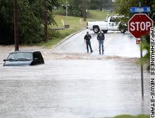
AUSTIN, Texas — With rivers and lakes filled to the brim and more rain in the forecast, emergency officials in the U.S. state of Texas on Friday braced for more of the flooding that has severely damaged or destroyed 1,000 homes.
July 5: Water from Lake Corpus Christi pours out of several gates at the Lake Corpus Christi Reservoir Wesley Seale Dam near Mathis, Texas
State emergency management chief Jack Colley said all of Texas' major river basins are at flood stage, the first time that has happened since 1957. Major flooding was forecast on the Guadalupe River in Victoria and Calhoun counties, where it was expected to crest near Bloomington at just over 27 feet early Saturday. Flood stage is 20 feet.
"Mostly this time of year we're fighting wildfires ... The problem with this is, the water won't go away," he said Thursday.
• Monitor the situation in FOXNews.com's Natural Disasters Center.
Other areas of concern include the Brazos, Sabine and Trinity rivers and Nueces River near Corpus Christi, Colley said.
Floodwaters slowly subsided Thursday in parts of Oklahoma and Kansas. Concerns eased that a full Lake Texoma along the Oklahoma-Texas line would send floodwaters into the Red River.
The U.S. Army Corps of Engineers said water could spill over the Denison Dam on Friday, flooding areas to the south. Those living in farm areas near the river were told to move their belongings to higher ground and have an evacuation plan.
Early Friday, Lake Texoma's level topped 639 feet, well past its normal elevation of 619 feet and just shy of the top of the spillway — 640 feet, according to the Corps.
"It's still rising but right now, we've been able to handle the flows and minimize the threat for downstream flooding," said Ed Rossman, assistant chief of planning for the Corps.
To the south, storms that began May 23 continued pounding Texas. The National Weather Service said 1 to 3 inches (of rain could fall Friday, with heavier amounts in isolated areas. On Thursday night, rainfall amounts in the past 24 hours included 5 inches (13 centimeters) in coastal Palacios, 2.2 inches at Houston's Hobby Airport and 1.9 inches (4.8 centimeters) in Rockport.
Flash flood warnings were issued overnight for several counties in northern Texas. Flooding washed out a bridge in Anderson County early Friday and authorities closed at least two roads, a dispatcher said. Hunt County also reported road closures.
Michael Gittinger, a meteorologist with the National Weather Service, said a series of low-pressure systems that have hovered over Texas for three weeks, combined with moist bands of air from the Gulf of Mexico, have fueled the near-record rainfall. The system is forecast to move northward through Arkansas and toward the East Coast.
The affected area covers 49 counties and 48,000 square miles from northern Texas to the Rio Grande Valley, a section roughly the size of Greece. Thirteen deaths have been blamed on the weather in the past 2 1/2 weeks in the state, Gov. Rick Perry's office said.
The latest death occurred early Thursday near Clifton in Bosque County, when a car driven by a 37-year-old woman hydroplaned, collided with a curb and plunged into a creek, authorities said.
Four people have been reported missing, including a 6-year-old boy swept into the Gulf of Mexico on Tuesday as strong currents ripped him from his father's arms at the mouth of the Brazos River in Freeport.
In Missouri, the body of a 16-year-old girl was found Wednesday night in a submerged SUV after she apparently tried to cross a flooded creek.
So far, the heaviest flood damage has been in Miami, Oklahoma, where the Neosho River crested at about 29 feet, its highest stage since 1951. The river was not expected to be back within its banks until late Sunday.
About 600 homes and businesses were believed damaged, City Manager Mike Spurgeon said. More than 30 area roads were still closed Thursday.
Spurgeon estimated it could take six months to a year to rebuild in the parts of town most heavily damaged.
Displaced residents watched and waited, anxious to begin salvaging soggy belongings. Dorena Jackson walked near her neighborhood in Miami, Oklahoma, trying to get a glimpse of the home she left two days ago.
"I don't even have a change of clothes," Jackson said. "I lost everything as far as I know."
President Bush has issued federal disaster declarations for numerous counties in Texas, Kansas and Oklahoma, clearing the way for housing assistance and low-interest loans, and more declarations are expected. (FOX)
quote:twitter: BreakingNewsOn: BREAKING NEWS -- Police have blocked off all roads heading to the three New York city-area airports; reason unknown. -- BREAKING NEWS
9:26 PM BreakingNewsOn: Severe weather in the New York area has forced the closure of roads leading to New York city-area airports.
BreakingNewsOn: The National Weather Service confirmed that an F-1 tornado touched down on the Islip area of Long Island, New York; reports of damage.
http://wcbstv.com/watercooler/local_story_199150015.htmlquote:Op woensdag 18 juli 2007 22:06 schreef Frutsel het volgende:
Kan nergens iets vinden over dat bericht Roel
F2 Tornado strikes Brooklyn - First ever!
NEW YORK What was thought to be a violently windy thunderstorm that plowed through Brooklyn Wednesday morning turned out to be a weather event of historical proportions.
The National Weather Service confirmed that the storm brought with it Brooklyn's first ever tornado since such weather events were recorded. Officials measured it to be an EF2 twister, characterized by winds of anywhere from 111 to 135 miles per hour.
Between 4 a.m. and 7 a.m. a string of severe thunderstorms blew through the region, making for an incredible headache for morning commuters. Thousands of New Yorkers found themselves enduring hours of delays in the sweltering heat with subways shut down and vacant taxi cabs hard to come by.
A woman on Staten Island died in a car accident which officials say was a result of the horrible driving conditions. In Brooklyn, amazingly, only scattered minor injuries were reported.
Still, the tornado certainly rattled bones as well as bricks, especially in Bay Ridge.
"About 6:35 this morning it sounded like a freight rain coming down the driveway. The house was shaking and people were screaming," said Linda Mantia, who lives in the Bay Ridge section.
"I just wanted to lay down and die," Brooklyn resident May Johnson told CBS 2.
Eric Casanova couldn't believe what he saw out his window. "I looked out my window and the trees looked like dandelions. They were flowing all over the place," he said. "They say you get 15 minutes of fame, here in Bay Ridge it's 15 minutes of history."
Not only is the tornado the first ever in recorded history to touch down in Brooklyn, it's also the first to hit a New York City borough since 1995, when a twister struck Staten Island.
Outside of those two, there have been only two other tornadoes to strike New York City. The first touched down in Queens in 1985 and the second in Staten Island in 1990.
Record-keeping of tornadoes began nationwide in 1950.
NEW YORK What was thought to be a violently windy thunderstorm that plowed through Brooklyn Wednesday morning turned out to be a weather event of historical proportions.
The National Weather Service confirmed that the storm brought with it Brooklyn's first ever tornado since such weather events were recorded. Officials measured it to be an EF2 twister, characterized by winds of anywhere from 111 to 135 miles per hour.
Between 4 a.m. and 7 a.m. a string of severe thunderstorms blew through the region, making for an incredible headache for morning commuters. Thousands of New Yorkers found themselves enduring hours of delays in the sweltering heat with subways shut down and vacant taxi cabs hard to come by.
A woman on Staten Island died in a car accident which officials say was a result of the horrible driving conditions. In Brooklyn, amazingly, only scattered minor injuries were reported.
Still, the tornado certainly rattled bones as well as bricks, especially in Bay Ridge.
"About 6:35 this morning it sounded like a freight rain coming down the driveway. The house was shaking and people were screaming," said Linda Mantia, who lives in the Bay Ridge section.
"I just wanted to lay down and die," Brooklyn resident May Johnson told CBS 2.

Eric Casanova couldn't believe what he saw out his window. "I looked out my window and the trees looked like dandelions. They were flowing all over the place," he said. "They say you get 15 minutes of fame, here in Bay Ridge it's 15 minutes of history."
Not only is the tornado the first ever in recorded history to touch down in Brooklyn, it's also the first to hit a New York City borough since 1995, when a twister struck Staten Island.
Outside of those two, there have been only two other tornadoes to strike New York City. The first touched down in Queens in 1985 and the second in Staten Island in 1990.
Record-keeping of tornadoes began nationwide in 1950.

Doden bij overstromingen in binnenland VS
(Novum/AP) - In de Amerikaanse staten Minnesota en Wisconsin hebben zware stormen in combinatie met hevige regenval in de nacht van zaterdag op zondag voor veel overlast gezorgd. Minstens vier mensen kwamen om het leven door overstromingen, die bruggen en wegen wegspoelden.
De slachtoffers vielen in Minnesota bij de plaatsen Stockton en Wikota, toen in twee gevallen de inzittenden van een auto verdronken omdat zij door het snel stijgende water geen kans meer zagen om uit hun voertuig te komen. In Wisconsin zorgde dertig centimeter regen voor een modderstroom die een huis meevoerde en midden op de rijksweg achterliet. Bruggen en wegen werden vanwege de regen afgesloten en enkele dorpen zijn zondag ontruimd, meldden de autoriteiten.
bron: