WKN Weer, Klimaat en Natuurrampen
Lees alles over het onstuimige weer op onze planeet, volg orkanen en tornado's, zie hoe vulkanen uitbarsten en hoe Moeder Aarde beeft bij een aardbeving. Alles over de verwoestende kracht van onze planeet en tal van andere natuurverschijnselen.


Kijkt u zelf:quote:Op zaterdag 5 mei 2007 20:26 schreef PizzaSalami het volgende:
Wat maken jullie je druk .

Vaag topic.
Never in the entire history of calming down did anyone ever calm down after being told to calm down.
Waarom is dit nieuws? Er zijn een paar honderd tornado's per jaar daar, het is niet hier, wat is de nieuwswaarde?
Ja, ik mag weer :6
*O* 9-12-2009 @ Paul McCartney *O*
*O* 9-12-2009 @ Paul McCartney *O*
Uit Groot alarm voor naderende tornado in Arnold
Het plaatsje Greensburg, waar 90% van alle gebouwen, inclusief ziekenhuis, verwoest is.
Het plaatsje Greensburg, waar 90% van alle gebouwen, inclusief ziekenhuis, verwoest is.
Oh ben je er zo een Zolang het niet in mijn achtertuin gebeurt boeit het mij niet of er 100en doden vallen, dat is hun probleem....quote:Op zaterdag 5 mei 2007 20:52 schreef Sexy_Sadie het volgende:
Waarom is dit nieuws? Er zijn een paar honderd tornado's per jaar daar, het is niet hier, wat is de nieuwswaarde?
Ik lees nergens honderden doden, maar om toch serieus op je in te gaan: er zijn daar honderden tornado's per jaar, waarvan tientallen zeer groot. Wat is hier de nieuwswaarde van?quote:Op zaterdag 5 mei 2007 20:59 schreef Hi_flyer het volgende:
[..]
Oh ben je er zo een Zolang het niet in mijn achtertuin gebeurt boeit het mij niet of er 100en doden vallen, dat is hun probleem....
Ja, ik mag weer :6
*O* 9-12-2009 @ Paul McCartney *O*
*O* 9-12-2009 @ Paul McCartney *O*
Blijkbaar genoeg, anders was het geen ''breaking news'' op cnn.quote:Op zaterdag 5 mei 2007 21:05 schreef Sexy_Sadie het volgende:
[..]
Ik lees nergens honderden doden, maar om toch serieus op je in te gaan: er zijn daar honderden tornado's per jaar, waarvan tientallen zeer groot. Wat is hier de nieuwswaarde van?


Damn sta effe hiervan te kijken
Doe mee met het voorspellen van het weer!
Weekvoorspelling | Week 12 (invullen tot 16-03 - 11:59)
Maandvoorspelling Maart (Inzendingen gesloten)
Jaarvoorspelling 2025 / 2026
Weekvoorspelling | Week 12 (invullen tot 16-03 - 11:59)
Maandvoorspelling Maart (Inzendingen gesloten)
Jaarvoorspelling 2025 / 2026

Dat was een pittig briesje.
Patience is not one of my virtues, neither is memory. Or patience for that matter.

Het zijn er nu 9, maar kan nog wel gaan oplopen.quote:Op zaterdag 5 mei 2007 21:41 schreef Fredo24 het volgende:
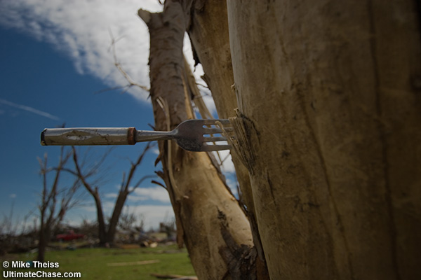
En toch nog 6 slachtoffers,als je naar die foto kijkt.
GREENSBURG, Kan. — Rescuers raced Saturday through the wreckage from a giant tornado that killed at least nine people and left little standing in this southwest Kansas town beyond the local pub.
Forecasters issued a fresh tornado warning Saturday evening in the region, where Friday's weather was blamed for nine deaths, a figure authorities feared could rise.
City Administrator Steve Hewitt estimated 95 percent of the town of 1,500 was destroyed and predicted rescue efforts could take days as survivors could be trapped in basements and under rubble.
Among the only structures that survived was the Bar H Tavern, the town's only bar. It was briefly converted into a morgue.
Survivors of the storm picked over the remnants of their homes and possessions, still dazed by the twister's strength and scope.
Jackie Robertson and her family spent Saturday afternoon collecting wedding photos, a wallet and other belongings from the debris that had been her home.
Robertson, her husband and a friend spent Friday night in a cellar when the storms struck the area.
"My heart just aches for everyone," she said. "It is so surreal. This is where I live."
The town, previously best known as the home of the world's largest hand-dug well — 32 feet in diameter, 109 feet deep when it was finished in 1888 — was a nightmare of splintered homes and smashed vehicles, the air redolent with the smell of sap from trees stripped of bark.
"We want everybody to know, and I plead to the American people as well as the people here in Kansas, this is a huge catastrophe that has happened to our small town," Hewitt said during a news conference. "All my downtown is gone. My home is gone. My staff's homes are gone. And we've got to find a way to get this to work and come to work every day and get this thing back on its feet. It's going to be tough."
Residents said they heard the tornado warning sirens — a common feature of towns in "Tornado Alley" — about 20 minutes before the storm hit.
National Weather Service meteorologist Larry Ruthi said the path of damage was 1.4 miles wide, estimating it would be classified a "upper F-4 or an F-5" tornado, the strongest possible.
"I'm in downtown Greensburg. There's really nothing left," Ruthi said.
Jose Peraza said he was driving his oil rig into town when he heard the siren and driving hail started pounding the area. He pulled over and hid with several other people in a convenience store freezer.
He said the storm ripped the side off the freezer, and when he came out he found the twister had thrown his truck — weighed down by 40,000 pounds of oil — "like nothing."
The dead included eight in Kiowa County, where Greensburg is located, and one in nearby Stafford County, said Sharon Watson, a spokeswoman for the Kansas Adjutant General's Department.
"We continue to find folks and this will go on for a good couple days — the rescue itself," Hewitt said. "I mean, the debris is just unbelievable. Even if you are in a basement, I mean your home is collapsed, and we've got to find a way to get to you."
State Rep. Dennis McKinney, the House minority leader and a Greensburg resident, said he hid in his basement with his daughter as the storm destroyed his house.
"It was very loud, but not as loud as I thought it would be," McKinney said. "It was over in a minute or two, the devastation was so fast."
He said he spent the evening and early morning conferring with emergency officials and helping search homes for survivors, although he noted "the inspections didn't take that long because in the western part of town, there weren't many homes left to inspect."
Residents said they heard the tornado warning sirens, a common feature of towns in "Tornado Alley," about 20 minutes before the storm hit.
"We had ample warning and that's why, with such huge devastation, that we're fortunate that we didn't have more fatalities than we had," McKinney said.
A mandatory evacuation was ordered, he said. Gov. Kathleen Sebelius declared a disaster emergency for Kiowa County, said her spokeswoman Nicole Corcoran. The state sent 40 National Guard soldiers to help.
The White House said President Bush was briefed on the situation. Federal Emergency Management Agency spokeswoman Dawn Kinsey said FEMA was preparing to help once Kansas officials request assistance. "We've been in contact with them since the beginning," Kinsey said.
Scores of injured people were sent to hospitals as far away as Wichita, 110 miles away. More than 70 went to Pratt Regional Medical Center about 30 minutes away, with all but 14 treated and released, said hospital spokeswoman Kim Stivers.
Rescuers pulled about 30 people from the basement of a partially collapsed hospital early Saturday, but most of them had minor injuries, Watson said.
The twister was part of a storm front that spawned tornadoes along a line stretching northeast from Greensburg through central Kansas. Three small tornadoes touched down in rural southwestern Illinois, but no damage was reported. Two more struck in Oklahoma and another in South Dakota, damaging some structures, officials said.
Yet another twister struck Saturday in central Nebraska, damaging outbuildings and power lines, officials said.
No injuries were reported in any of those states.


Waar blijft die tornado van TS nou?quote:VS weer getroffen door tornado's
***************************************
` Het midden van de Verenigde Staten is
opnieuw getroffen door tornado's.De
wervelwinden waren in de staten Kansas,
South Dakota en Oklahoma.In Kansas
raakten elf mensen gewond toen twee
restaurants werden getroffen.
Een precies overzicht van de schade en
het aantal slachtoffers is er nog niet.
De communicatie met het getroffen
gebied verloopt moeizaam.
Vrijdagnacht werd het stadje Greensburg
in Kansas bijna helemaal verwoest door
een tornado.Er vielen negen doden,maar
onder het puin liggen mogelijk nog meer
slachtoffers.Het reddingswerk wordt
door de nieuwe tornado's bemoeilijkt
Never in the entire history of calming down did anyone ever calm down after being told to calm down.
Oh damn,wat zou ik graag in die auto willen zitten!quote:Op zondag 6 mei 2007 12:09 schreef ItaloDancer het volgende:
http://www.youtube.com/watch?v=DNL7ASvl4k4 (als ie nog niet gepost is)
Tornado komt wel erg dichtbij trouwens.
En check die laatste foto,
alleen dat flatgebouw(of wat het mag zijn) staat nog overeind.

Gaat lekker daar in de US . Gisteren was bij 't NOS Journaal ook even een beeld van die tornado te zien. Uitzonderlijk breed ook. Indrukwekkend. Je zult 't op je af zien komen .
Tering .quote:Op zondag 6 mei 2007 12:09 schreef ItaloDancer het volgende:
http://www.youtube.com/watch?v=DNL7ASvl4k4 (als ie nog niet gepost is)
Hier een filmpje na die tornado.
http://www.youtube.com/watch?v=5NE9LJ9rNTU
http://www.youtube.com/watch?v=5NE9LJ9rNTU
Doe mee met het voorspellen van het weer!
Weekvoorspelling | Week 12 (invullen tot 16-03 - 11:59)
Maandvoorspelling Maart (Inzendingen gesloten)
Jaarvoorspelling 2025 / 2026
Weekvoorspelling | Week 12 (invullen tot 16-03 - 11:59)
Maandvoorspelling Maart (Inzendingen gesloten)
Jaarvoorspelling 2025 / 2026
Tornado Destroys Kansas Town, Kills 9 (ABC)
The eerie beeping of battery-operated fire alarms buried beneath mounds of debris punctured the silence that fell over this community as hundreds of rescue workers pulled out of town. News of another approaching storm brought an uneasy quiet Saturday night as emergency crews called off the search for more victims of a tornado that killed at least eight people and devastated this southwest Kansas farming town a day earlier.
The National Weather Service said it had received reports "well into the double digits" of twisters touching down in six southwest Kansas counties. Numerous tornadoes were reported from South Dakota south into Oklahoma as forecasters scrambled to keep issuing warnings.
President Bush declared parts of Kansas a disaster area, freeing up federal money to aid in recovery.
"We need support," said Greensburg Administrator Steve Hewitt. "We want everybody to know this is a huge catastrophe."
At least eight people have died in the Greensburg area. Friday's weather was blamed for nine deaths in the region, a number authorities feared could rise even before the latest twisters. All its residents have been evacuated.
Among the few structures that survived was the Bar H Tavern. It was briefly converted into a morgue. Command operations for rescue efforts were moved into the town's stately courthouse, damaged but also still standing.
All the churches have been destroyed. Every business along the town's main street has been demolished for most, all that remains are steel girders, tattered insulation, splintered wood. The towns fire engines were crushed. Other crumpled vehicles were tossed into the melee.
The town's claim to fame is the world's biggest hand dug well. Its condition is unknown because it is buried under a mountain of debris. The attraction's gift store has disappeared.
For decades, meteorite hunters from throughout the world have been drawn here to hunt for space rocks in the rich soil near here. The town's extensive meteorite collection, including its famed 1,000-pound pallasite meteorite, is casualty of the storm.
percent of the town of 1,500 was destroyed and predicted rescue efforts could take days as survivors could be trapped in basements and under rubble.
Hewitt, who lost his home in the storm, was somber as he told reporters he was concerned what will happen to his community once all the volunteers and searchers ultimately go home.
"This is one of the most devastating tornadoes we have had in Kansas," said U.S. Rep. Jerry Moran.
U.S. Sen. Sam Brownback and Gov. Kathleen Sebelius will tour the storm-damaged area Sunday.
But at the shelter in neighboring Haviland, resident Cheryll Behm was skeptical. Her own storm-damaged house is probably repairable, but she said there is no town left. She is a nurse's aide who worked at the local hospital.
"I am concerned Greensburg never will be built," she said. "There is no place to go back to work to. All of Main Street is gone."
Scores of injured people were sent to hospitals as far away as Wichita, 110 miles away. More than 70 went to Pratt Regional Medical Center about 30 minutes away, with all but 14 treated and released, said hospital spokeswoman Kim Stivers.
Rescuers pulled about 30 people from the basement of a partially collapsed hospital early Saturday, but most of them had minor injuries, said Sharon Watson, spokeswoman for the Kansas Adjutant General's Department.
The twister was part of a storm front that spawned tornadoes along a line stretching northeast from Greensburg through central Kansas. At least seven more tornadoes were reported late Friday and Saturday in Illinois, Oklahoma, South Dakota and Nebraska, though damage was minimal, officials said.
In Oklahoma, a tornado tore through the small town of Sweetwater, causing at least one injury and damaging the town's high school and other structures, authorities said.
Television footage showed a large twister hitting the Erick-Sweetwater High School and storm spotters reported damage to nearby residences in the far western Oklahoma town of about 100 that straddles the Beckham-Roger Mills county line
Nieuwe golf van tornado's treft Kansas
WICHITA/TOPEKA - Een nieuwe golf van tornado's heeft zaterdagavond het middenwesten van de Verenigde Staten getroffen. Van het noorden van Texas, door Oklahoma, Kansas, Nebraska tot aan South Dakota kregen mensen het advies extra waakzaam te zijn op zware wervelstormen.
De Amerikaanse nationale meteorologische dienst telde tientallen zogenoemde twisters, meldden lokale media zondag.
Berichten over doden zijn er niet, wel raakten minstens elf mensen gewond toen verscheidene restaurants werden getroffen in Osborne, Kansas. Uit het westen van Oklahoma kwamen ook berichten van gewonden nadat een tornado gebouwen had getroffen in de plaats Sweetwater.
Doden
Het noodweer bemoeilijkt de reddingswerkzaamheden in de plaats Greensburg ernstig. Het 1500 zielen tellende plaatsje in Kansas kreeg vrijdag de volle laag en is nagenoeg volledig weggevaagd. De autoriteiten hebben er tot nog toe negen doden geteld, maar dat aantal kan makkelijk oplopen.
"We hebben berichten van lokale zieknhuizen dat er circa zestien mensen in kritieke toestand verkeren en dat een vijftigtal anderen wordt behandeld", aldus een woordvoerster van de statelijke autoriteiten.
Vermist
Tal van mensen worden nog vermist. Ze zitten mogelijk nog gevangen in schuilkelders onder hun kompleet verwoeste huizen. Van de gebouwen in Greensburg staat nog geen 5 procent nog overeind. Het kan dagen duren voordat iedereen is bevrijd van onder zijn huis, zeggen lokale bestuurders.
Wow die foto, echt erg.
Offtopic: waarom staat er niet gewoon '9 doden' ipv in 't Engels?
Opm DH : Aangepast.
[ Bericht 7% gewijzigd door Drugshond op 06-05-2007 16:24:16 ]
Offtopic: waarom staat er niet gewoon '9 doden' ipv in 't Engels?
Opm DH : Aangepast.
[ Bericht 7% gewijzigd door Drugshond op 06-05-2007 16:24:16 ]
Ter vergelijking.
De onderste foto is van hiroshima net na WO-II.
quote:Op zondag 6 mei 2007 13:35 schreef Frutsel het volgende:
De onderste foto is van hiroshima net na WO-II.
Heet lijkt inderdaad wel of er een grote bom is gevallen.
Patience is not one of my virtues, neither is memory. Or patience for that matter.
Inderdaad ja, alsof er een atoombom gevallen is.quote:Op zondag 6 mei 2007 16:22 schreef Drugshond het volgende:
Ter vergelijking.
[..]
[afbeelding]
De onderste foto is van hiroshima net na WO-II.
Deze week nog wel meer tornado's, denk ik.
Kaartje van dinsdag
Omdat de rest van de titel ook in het engels was... maar goed... ik zie het al...quote:Op zondag 6 mei 2007 15:45 schreef Eveli het volgende:
Wow die foto, echt erg.
Offtopic: waarom staat er niet gewoon '9 doden' ipv in 't Engels?
Opm DH : Aangepast.
En jij dacht dat Nederland zo'n tornado overleeft? Sukkel. Heb je enig idee van de vernietiging die een F4 of F5 tornado achterlaat? Je weet dat dat winden zijn van 450km per uur? Jullie janken al bij een Noordwesterstormpje van 60km per uur.quote:Op zaterdag 5 mei 2007 20:25 schreef DikkeSmikkel het volgende:
[..]
Dat krijg je als je zo'n beetje alles van hout maakt he...
"Welfare culture is bad not just because, as in Europe, it's bankrupting the state, but because it enfeebles the citizenry, it erodes self-reliance and resourcefulness."
-Mark Steyn
-Mark Steyn
Blijft maar doorgaan met die tornado's
National Weather Service
quote:Kansas maakt zich klaar voor derde tornadoserie
In het zuiden van Kansas is zondag alweer een tornado waargenomen. Het is mogelijk de eerste tornado van een nieuwe serie. Voor de derde achtereenvolgende dag ontstaan vooral 's avonds zware buien met tornado's langs een koufront. Op 5 kilometer hoogte staat een orkaanachtige zuidwestelijke stroming die de zware buien extra stimuleert.
Zowel op 4 als op 5 mei mei werd hetzelfde gebied getroffen met op 4 mei 9 doden tot gevolg. Op 5 mei was met 92 tornadowaarnemingen sprake van een van de grootste tornado-uitbraken van de afgelopen jaren.

National Weather Service
Het is iig wel opvallend dat mensen opgevangen werden in een Rode Kruis-gebouw van steen.quote:Op zondag 6 mei 2007 22:44 schreef StefanP het volgende:
En jij dacht dat Nederland zo'n tornado overleeft? Sukkel. Heb je enig idee van de vernietiging die een F4 of F5 tornado achterlaat? Je weet dat dat winden zijn van 450km per uur? Jullie janken al bij een Noordwesterstormpje van 60km per uur.
Never in the entire history of calming down did anyone ever calm down after being told to calm down.
Kijk dat vind ik nou eens een nuttige opmerkingquote:Op zondag 6 mei 2007 22:44 schreef StefanP het volgende:
[..]
En jij dacht dat Nederland zo'n tornado overleeft? Sukkel. Heb je enig idee van de vernietiging die een F4 of F5 tornado achterlaat? Je weet dat dat winden zijn van 450km per uur? Jullie janken al bij een Noordwesterstormpje van 60km per uur.
450km/u is idd wel knetterhard.
Never in the entire history of calming down did anyone ever calm down after being told to calm down.
Leuk hoe je het omkeert zodat het over Nederland gaatquote:Op zondag 6 mei 2007 22:44 schreef StefanP het volgende:
[..]
En jij dacht dat Nederland zo'n tornado overleeft? Sukkel. Heb je enig idee van de vernietiging die een F4 of F5 tornado achterlaat? Je weet dat dat winden zijn van 450km per uur? Jullie janken al bij een Noordwesterstormpje van 60km per uur.
Maar even serieus: er zijn genoeg Amerikanen die zelf toegeven dat het best dom is om zoveel met hout te bouwen, en dat stenen huizen tegen veel meer natuurgeweld bestand zijn.
Maarja, hout is goedkoper hè...? En makkelijker in elkaar te zetten
Enne, het is zuidwester storm, en de snelheden zijn bij een storm meer dan 100 km/u. En dan niet lokaal, maar bijvoorbeeld langs de hele kust of in het halve land... Als je Nederlanders wilt kleineren, doe het dan wel goed.
Ja, ik mag weer :6
*O* 9-12-2009 @ Paul McCartney *O*
*O* 9-12-2009 @ Paul McCartney *O*
Weet je uberhaupt wel waar je het over hebt? Een noordwesterstorm is veel erger dan een zuidwesterstorm. Over self-defeatism gesproken.quote:Op zondag 6 mei 2007 23:27 schreef Sexy_Sadie het volgende:
Enne, het is zuidwester storm, en de snelheden zijn bij een storm meer dan 100 km/u. En dan niet lokaal, maar bijvoorbeeld langs de hele kust of in het halve land... Als je Nederlanders wilt kleineren, doe het dan wel goed.
"Welfare culture is bad not just because, as in Europe, it's bankrupting the state, but because it enfeebles the citizenry, it erodes self-reliance and resourcefulness."
-Mark Steyn
-Mark Steyn
Hangt er van af, op sommige plekken is het zelfs verstandiger om van hout te bouwen o.a. in gebieden met aardbevingsgevaar. Een stenen huis geeft niks mee.quote:Op zondag 6 mei 2007 23:27 schreef Sexy_Sadie het volgende:
[..]
Leuk hoe je het omkeert zodat het over Nederland gaat
Maar even serieus: er zijn genoeg Amerikanen die zelf toegeven dat het best dom is om zoveel met hout te bouwen, en dat stenen huizen tegen veel meer natuurgeweld bestand zijn.
Maarja, hout is goedkoper hè...? En makkelijker in elkaar te zetten
Ze zouden juist in NL meer met hout en beton moeten doen, dat maakt de huizen misschien wat beter betaalbaar.
Patience is not one of my virtues, neither is memory. Or patience for that matter.
Kansas twister death toll rises to 12
GREENSBURG, Kansas (CNN) -- The death toll from the weekend's tornado-packing storms in Kansas rose to 12 Monday when authorities found the bodies of two more victims in Greensburg.
Previously, officials had said eight people died in Greensburg; that total rose to 10, said City Administrator Steve Hewitt.
Another victim died Friday night in Stafford County to the northeast, and one died Saturday night in a separate tornado in Ottawa, Kansas.
Authorities also found a survivor buried beneath the rubble in Greensburg.
"Last night, late evening, we did recover someone alive," said Ronald Knoefel with the Kansas Highway Patrol. "So we are very very happy with that. ... The search and rescue continues because we still have optimism that we're going to find more people alive."
Hewitt said search and rescue efforts in the town were continuing after Friday's mile-wide twister with winds of 205 mph. (Watch treetops sheared off amid a flying American flag )
Kansas Gov. Kathleen Sebelius told CNN the rubble was so deep in some places that even trained dogs might be unable to pick up the scent of people who may be buried beneath.
Word of the rescue came as residents returned to the town of 1,500, to inspect what was left of their homes. But visiting privileges were suspended for about half of the town after an ammonia leak from a railroad tank car prompted authorities to evacuate the area as a precaution.
Authorities said the tanker containing about 14,000 gallons of ammonia had overturned in the storm, and the leak began when workers tried to right it.
http://www.knack.be/nieuw(...)n26-article3439.htmlquote:Bush belooft Greensburg hulp na zware tornado
07/05/2007 14:53
De Amerikaanse president George W. Bush heeft gisteren de stad Greensburg in de staat Kansas uitgeroepen tot noodgebied, zo melden verscheidene Amerikaanse media. Hierdoor komt de plaats in aanmerking voor federale hulp. Die hulp wordt echter belemmerd door de oorlog in Irak.
In Greensburg is 90 procent van de gebouwen vernietigd of zwaar beschadigd door de tornado, die in de nacht van vrijdag op zaterdag plaatshad. Een groot deel van de ongeveer 1.600 inwoners is zijn huis kwijtgeraakt. 'Het gaat lang duren voordat de gemeenschap er weer bovenop is,' zei Bush tijdens een gedenkdienst in Washington D.C. 'Maar ik ben ervan overtuigd dat de stad weer wordt opgebouwd. We zullen daarbij zoveel mogelijk helpen.'
De wervelstorm heeft aan zeker negen mensen het leven gekost. Ook vielen er tientallen gewonden door het natuurgeweld. Reddingswerkers zijn nog op zoek naar overlevenden in het puin.
Ook andere delen van Kansas en de staten South Dakota en Oklahoma zijn getroffen door tientallen tornado's. Enkele honderden kilometers ten noordoosten van Greensburg is één man omgekomen in het noodweer. In de plaats Osborne zijn elf gewonden gevallen. Bush heeft zijn medeleven betuigd aan de nabestaanden van Amerikanen die zijn omgekomen bij de stormen.
De bergingswerken worden nu belemmerd door de Irakoorlog. Niet alleen bevindt meer dan 40 procent van de nationale garde uit Kansas zich momenteel in Irak, maar ook de helft van alle vrachtwagens. Dat zei de gouverneur van Kansas, Kathleen Sebelius, maandag op de nieuwszender CNN. Er ontbreekt allerhande materiaal. Daarom kwam de eerste hulp van de nationale garde slechts traag op gang. Kansas heeft nu andere staten om hulp gevraagd.
(Elsevier/Belga)
Misschien omdat het niet veel voorkomt dat een heel dorp wordt weggevaagdquote:Op zaterdag 5 mei 2007 21:05 schreef Sexy_Sadie het volgende:
[..]
Ik lees nergens honderden doden, maar om toch serieus op je in te gaan: er zijn daar honderden tornado's per jaar, waarvan tientallen zeer groot. Wat is hier de nieuwswaarde van?
Gaat flink tekeer daar. Heb zin in de zomer

Hier is een filmpje van die tornado in Greensburg.
Goed kijken, want het was wel nacht natuurlijk. Af en toe is ie zichtbaar, door het weerlicht.
Goed kijken, want het was wel nacht natuurlijk. Af en toe is ie zichtbaar, door het weerlicht.
<a href="http://www.vwkweb.nl/" rel="nofollow" target="_blank">[b]Vereniging voor weerkunde en klimatologie[/b]</a>
<a href="http://www.estofex.org/" rel="nofollow" target="_blank">[b]ESTOFEX[/b]</a>
<a href="http://www.estofex.org/" rel="nofollow" target="_blank">[b]ESTOFEX[/b]</a>
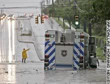
Kansas towns flee as floodwaters rise
HUTCHINSON, Kansas (AP) -- Torrential rainfall hit parts of the Plains and Midwest, flooding towns in Kansas on Thursday, toppling trees and power lines and pelting the countryside with hail.
Some central Kansas towns recorded as much as 7 inches of rain -- in some places up to 2 inches per hour -- starting Wednesday.
The deluge closed dozens of roads, some flooded for the second time in three weeks, said Dean Speaks, deputy emergency management director for Saline County. (Watch cars struggle through water )
"It's taken out the roads that we fixed (after the first flooding)," Speaks said. Numerous government facilities, homes and businesses in the Salina area were flooded.
Everyone in the Saline County towns of Bavaria and Hedville -- about 80 people -- evacuated their homes overnight. Fifty homes in Ogden, near Fort Riley, were being voluntarily evacuated as area creeks rose.
In Hutchinson, many motorists had to be helped from their cars as water flooded streets.
"In some places, there are people with water up to their porches," Hutchinson Fire Chief Kim Forbes said. Fire trucks were used to help move people to higher ground or to shelters.
The storms also spawned tornadoes and funnel clouds, but no significant tornado damage was reported. Toppled trees and power lines were reported in Minnesota and Wisconsin.
The National Weather Service posted a flood warning for the Big Nemaha River in southeastern Nebraska. It was expected to crest 3 feet over flood stage late Thursday evening or night, and rain was forecast through mid-afternoon.
Freak Hail Storms in Denver
DENVER, Colorado (AP) -- Grape-size hail pummeled the city on Tuesday, blanketing downtown streets, startling drivers and pedestrians, and piling up 4 inches deep at an amusement park.
Motorists scurried under bridges or into garages and pedestrians scrambled for cover to avoid being pelted.
Brazil Redd, 21, was outside when the rain and hail began, her car being towed after a hit-and-run collision.
"It hurt. I probably got bruises. It was huge," she said. "I got soaked."
At Elitch Gardens amusement park, the hail broke lights and toppled small trees, prompting the park to close several hours early, spokeswoman Brooke Gabbert said.
Visitors were led to shelters and then moved out of the park after the storm passed.
"With the severe hail, we have to recheck all the rides. It would've been a while before we would have been able to reopen," Gabbert said.
Drivers were caught in up to 3 feet of water in some intersections, but no serious injuries were reported, Denver Fire Department spokesman Phil Champagne said.
Marty Thrall plodded through a half-inch of hail in a short-sleeved T-shirt, shorts and sandals.
"I didn't know it was going to be this icy," he said.
Heavy rain soaked the Plains states from Colorado up to Minnesota Tuesday, causing minor flooding in some places.
The National Weather Service issued tornado warnings for Elbert County, 60 miles southeast of Denver, and for Lincoln County in southwestern Nebraska.
=====
WTF!!! Grapefruit Hagel? Je zult het maar op je harses krijgen
Ow.. Grape zal wel Druif zijn Das beter voor te stellen
[ Bericht 3% gewijzigd door Frutsel op 31-05-2007 17:21:41 ]
Wordt steeds gekker
Doe mee met het voorspellen van het weer!
Weekvoorspelling | Week 12 (invullen tot 16-03 - 11:59)
Maandvoorspelling Maart (Inzendingen gesloten)
Jaarvoorspelling 2025 / 2026
Weekvoorspelling | Week 12 (invullen tot 16-03 - 11:59)
Maandvoorspelling Maart (Inzendingen gesloten)
Jaarvoorspelling 2025 / 2026
Een "grape" is een druif
"Pain is my friend. I can trust pain. I can trust pain to make my life utterly miserable."
"My brain is too smart for me."
"We don't need no education." "Yes you do, you just used a double negative."
"My brain is too smart for me."
"We don't need no education." "Yes you do, you just used a double negative."
ik kwam er net zelf ook achter toen ik het bericht opnieuw doorlasquote:Op donderdag 31 mei 2007 17:20 schreef wonderer het volgende:
Een "grape" is een druif
damn, toch nog iemand die het zag, voordat ik het zelf herstelde

Tornadoes strike northern Wisconsin
A series of tornadoes ripped through the Upper Midwest region of the United States in the evening of June 7, 2007. At least five different tornadoes touched down in Wisconsin, according to the Associated Press, one of which tore through the Bear Paw Resort in northern Wisconsin. Despite dropping as much as fifteen centimeters (six inches) of rain in some places and baseball-size hail in others, authorities were reporting no deaths attributable to the storm system, and only a smattering of injuries, but considerable property damage in some areas.
When the MODIS instrument on NASA’s Terra satellite observed the area on June 9, 2007, the track torn through the woods by one of the tornadoes stands out quite clearly. This photo-like image uses data collected by MODIS in the normal human vision range to give a familiar natural-looking appearance. The landscape is largely a checkerboard of farms, towns, roads, and cities. The pale land is predominantly farmland where crops have not fully grown in yet. Dark blue shows the winding path of rivers and lakes dotting the landscape. The large blue lake on the east (right) side of the image is Lake Michigan. Towns and cities, including the city of Green Bay, are gray. To the north side, farmland gives way to dark green as land use shifts from agriculture to the Menominee Indian Reservation and Nicolet National Forest. The diagonal slash through the dark green forested land shows the tornado track. Bare land was revealed where the tornado tore down trees or stripped vegetation off the branches.
Een spoor van meer dan 50 km zo te zien.quote:Op maandag 11 juni 2007 23:26 schreef Frutsel het volgende:
[afbeelding]
Tornadoes strike northern Wisconsin
A series of tornadoes ripped through the Upper Midwest region of the United States in the evening of June 7, 2007. At least five different tornadoes touched down in Wisconsin, according to the Associated Press, one of which tore through the Bear Paw Resort in northern Wisconsin. Despite dropping as much as fifteen centimeters (six inches) of rain in some places and baseball-size hail in others, authorities were reporting no deaths attributable to the storm system, and only a smattering of injuries, but considerable property damage in some areas.
When the MODIS instrument on NASA’s Terra satellite observed the area on June 9, 2007, the track torn through the woods by one of the tornadoes stands out quite clearly. This photo-like image uses data collected by MODIS in the normal human vision range to give a familiar natural-looking appearance. The landscape is largely a checkerboard of farms, towns, roads, and cities. The pale land is predominantly farmland where crops have not fully grown in yet. Dark blue shows the winding path of rivers and lakes dotting the landscape. The large blue lake on the east (right) side of the image is Lake Michigan. Towns and cities, including the city of Green Bay, are gray. To the north side, farmland gives way to dark green as land use shifts from agriculture to the Menominee Indian Reservation and Nicolet National Forest. The diagonal slash through the dark green forested land shows the tornado track. Bare land was revealed where the tornado tore down trees or stripped vegetation off the branches.
Daar staat geen boom meer overeind.
Er staat daar niet meer zoveel overeind
Zie de vele pics @ http://www.channel3000.com/slideshow/news/13469737/detail.html en http://www.channel3000.com/slideshow/news/13428507/detail.html (hagel zo groot als een baseball ) . Meer filmpjes en foto's @ http://www.channel3000.com/news/13464999/detail.html en http://news.google.nl/news?hl=en&ned=us&q=Bear+Paw+Resort+ .
Zie de vele pics @ http://www.channel3000.com/slideshow/news/13469737/detail.html en http://www.channel3000.com/slideshow/news/13428507/detail.html (hagel zo groot als een baseball ) . Meer filmpjes en foto's @ http://www.channel3000.com/news/13464999/detail.html en http://news.google.nl/news?hl=en&ned=us&q=Bear+Paw+Resort+ .
Hagelsteentjesquote:Op dinsdag 12 juni 2007 19:48 schreef Roel_Jewel het volgende:
Er staat daar niet meer zoveel overeind
Zie de vele pics @ http://www.channel3000.com/slideshow/news/13469737/detail.html en http://www.channel3000.com/slideshow/news/13428507/detail.html (hagel zo groot als een baseball ) . Meer filmpjes en foto's @ http://www.channel3000.com/news/13464999/detail.html en http://news.google.nl/news?hl=en&ned=us&q=Bear+Paw+Resort+ .

Hagel komt vaker voor in de VS.
quote:Records en historische feiten
Grootste (enkelvoudige) hagelsteen in Nederland:
waarschijnlijk 9 cm, 6 juni 1998 te Nunspeet (is nog officieus).
Grootste (enkelvoudige) hagelsteen op aarde:
15.2 cm doorsnede, 766 gram zwaar op 3 sept. 1970 in Coffeyville (Kansas, VS).
Meest getroffen gebied met hagel:
In Cheyenne (Wyoming) komen 9 tot 10 echte hagelstormen voor per jaar. Ook het noordwesten van Kansas en noorden van Colorado (VS) behoren tot de meest getroffen gebieden.
In El Dorado (Kansas) viel op 23 juni 1951 de hagel tot een dikte van 30 cm.
In Hyderabad (India) waren op 17 maart 1939 samengestelde stenen gevallen met een gewicht van ca. 3,5 kg.
In Kansas en Missouri viel 23 juni 1951 de hagel in een strook van ruim 300 km lang. Totale schade: meer dan 14 miljoen dollar (de meeste schade in de VS).
2 die as heavy rains bring flooding to Texas cities
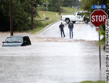
HALTOM CITY, Texas (AP) -- Torrential overnight rainfall flooded a handful of north Texas towns Monday, killing two people and stranding residents and their pets on the roofs of their homes awaiting rescue.
Creeks swollen by as much as 8 inches of rain inundated parts of the towns of Gainesville and Sherman near the Oklahoma state line.
A 4-year-old girl, Alexandria Collins, was swept away to her death while firefighters were trying to rescue her and her mother from their home in Haltom City, a Fort Worth suburb. Her body was found more than two hours later.
"We were in the boat when the boat capsized," her mother, Natasha Collins, tearfully told KXAS-TV of Dallas. "The current swept her from my arms."
But firefighters said the girl was already missing by the time they pulled her mother onto a boat.
A woman died in Sherman, about 60 miles northwest of Dallas near the Oklahoma state line, after her car stalled in rising water and was swept away, Sherman police Sgt. Bruce Dawsey said. A firefighter was struck by lightning but went back to work helping with rescues, he said. Watch floodwaters flow through city
About 125 residents of a Sherman nursing home were being evacuated, and an unknown number of people were being rescued from an office building where the roof started caving in, Dawsey said.
In Gainesville, aerial video showed dozens of people seeking refuge from the high water on a railroad crossing. Families awaited rescue on their roofs, some having hacked their way to the outside from their attics. Some were joined by their dogs. Watch rescuers pull residents from rooftops
Water had receded from parts of downtown Gainesville by midday.
About 100 mobile homes in Haltom City were inundated and many were washed off their foundations, emergency officials said.
"When I looked out the window, water was up to the bottom of the window and the current was so fast houses were washing away, said Haltom City resident Rachel Hawkes. "You could hear people screaming but we couldn't get out to help."
About 37,000 people live in Sherman and about 16,500 in Gainesville.
Authorities closed Interstate 35 from Gainesville to the Oklahoma state line for several hours, the Texas Department of Public Safety said. Some other roads in the region also were closed by high water.
The National Weather Service said rain fell at a rate of an inch every 15 minutes in some places early Monday.
"We get heavy rains in North Texas, but the rate, the amount, the duration and the coverage of this are just amazing," said Gary Woodall, the warning-coordination meteorologist for the weather service office in Fort Worth.
The weather service forecast a chance of isolated thunderstorms in the area Monday and Tuesday but said overall the weather was expected to improve.

Floods in Texas and Oklahoma
Heavy rains pounded the Southern Plains of the United States during mid-June when moisture from the Gulf of Mexico streamed northward into a slow-moving frontal system. The result was extensive flooding over parts of Texas and Oklahoma. On Monday, June 18, 2007, six flood-related deaths were reported in northern Texas as storms dumped up to 8 inches (abut 200 millimeters) of rain in the area. On Tuesday, additional storms dumped heavy rains over parts of northwestern Oklahoma, forcing several road closures, said news reports.
This image shows rainfall totals for June 14 through June 20, 2007. The rainfall totals are from the, near-real time Multi-satellite Precipitation Analysis (MPA), which is based on measurements taken by the Tropical Rainfall Measuring Mission (TRMM) satellite. The MPA analysis indicates that during this time more than 200 mm (~8 inches, red area) of rain fell in northern Texas just south of the Oklahoma border, where flooding was reported. A much broader area of at least 150 to 200 mm (about 6 to 8 inches) of rain covers most of northwest Oklahoma. Based on these totals, the TRMM team predicted that flooding was likely or occurring. The group produces a global map indicating where there is a high potential for flooding based on rainfall totals.

More tornadoes hit southern Manitoba (Canada)
Environment Canada is looking into reports that more tornadoes swept through southern Manitoba, a day after fierce twisters caused heavy damage in the town of Elie, west of Winnipeg.
Twisters were spotted Saturday evening near Pipestone, Minto, the Canupawakpa First Nation and an area between Hartney and Deloraine.
Environment Canada officials inspect the damage in Elie on Saturday.
(John Woods/Canadian Press) Ross Tycoles, the reeve of Pipestone, about 100 kilometres southwest of Brandon, was playing baseball when the wild weather hit. He said there was unusual cloud cover.
"Everything was moving and turbulent, up and down. There was severe lightning north of the town," he said.
Tycoles heard reports of damaged barns, garages and farm equipment near Pipestone, but no injuries. One woman he spoke to told him she was terrified as a twister passed dangerously close to her house.
Some houses were damaged on the Canupawakpa First Nation, he said.
WATCH THE VIDEO ---> http://www.cnn.com/video/(...)oba.tornado.stringer
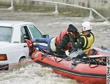
Downpour strands people on roofs, in trees
GEORGETOWN, Texas (AP) -- Torrential storms flooded parts of central Texas early Wednesday, stranding people on roofs, in trees and in vehicles, with wind-blown rain falling so hard that some helicopter rescue attempts had to be abandoned.
The worst flooding was in Williamson, Lampasas and Burnet counties in the Texas Hill Country northwest of Austin.
"We got hard facts of 18-plus inches of rain in a couple of those places since midnight," Austin-Travis County emergency medical services spokesman Warren Hassinger said just after 7 a.m.
More rain was expected throughout the day, the National Weather Service said.
Parts of Oklahoma also were soaked Wednesday, with rain falling on Oklahoma City for the 15th consecutive day, breaking a 70-year-old record. (Watch floodwaters swamp Oklahoma roads, fields )
Hassinger's agency had reports early Wednesday of at least 20 trapped atop vehicles, on roofs or clinging to trees surrounded by fast-moving water.
However, the weather was so stormy that helicopter crews had to abandon several rescue attempts, Hassinger said. He said four rescue attempts were halted before dawn and he didn't know what happened to the people needing help.
One aborted rescue mission had attempted to get four people from the roof of a house in Granite Shoals, where water was about 4 feet from the top of the building. They had pulled a possible drowning victim from the water, Hassinger said.
One successful helicopter-assisted rescue plucked a Williamson County sheriff's deputy and another person from atop the lawman's car along the San Gabriel River near Georgetown, Hassinger said. (Watch water pour down streets of Fort Worth )
Ray Thomas and his wife fled their house on a peninsula between the North and South San Gabriel rivers at about 4:45 a.m., after hearing an emergency weather radio bulletin.
"We're lucky we got out," he said. "In September we were praying for rain. What worries me now is the rain that's still to come."
Tuesday night, residents of at least 50 homes had to be evacuated from a flooded subdivision near Lake Granbury, about 60 miles southwest of Dallas. Rescuers used boats and jet skis to remove those residents as Robinson Creek rose out of its banks.
Speed of water's rise 'hard to believe'
About 30 evacuees spent Wednesday morning at the First United Methodist Church in Granbury, the Rev. Neil Norman said.
"There's some shock because the water must have come up extremely quickly," Norman said. "This is all pretty much hard to believe."
In Oklahoma, about 20 firefighters had to use a raft to rescue 16-year-old twin sisters from their car, stalled in rushing bumper-deep water Tuesday. (Watch terrified teens rescued from car )
The Oklahoma City area received about an inch of rain in 24 hours, bringing the city's annual total to 28.03 inches -- about 10 inches above normal. Flooding closed some roads Wednesday in central and northeastern Oklahoma.
"Anytime it rains there's going to be the threat of heavy downpours, it's not out of the question for any one area to get three inches," National Weather Service meteorologist Ty Judd said Wednesday in Norman, Oklahoma.
Boy dies after creek sweeps him away
A 13-year-old boy died in the Dallas suburb of Garland Tuesday night after being washed down a flooded creek, police spokesman Joe Harn said. The boy was swept away when firefighters using ropes tried to pull him ashore from a bridge pillar where he was stranded. He was found a mile downstream about two hours later, Harn said.
A number of flood warnings were posted throughout Texas. North Bosque River near Clifton was expected to crest at almost 29 feet early Wednesday, which is about 6 feet above normal.
Elsewhere, several Chicago streets and basements were flooded as parts of the city received 3 to 4 inches of rain in about 45 minutes, just before Tuesday's evening rush hour, according to the National Weather Service.
The water department received more than 700 reports of flooded basements, officials said.
Veel neerslag in Texas
Zware onweersbuien hebben in de nacht van dinsdag op woensdag veel neerslag bezorgd in Texas. De neerslag viel na een week met zware buien. In totaal zijn al 11 mensen om het leven gekomen door de overstromingen.
De meeste neerslag viel in Marble Falls, ongeveer 60 kilometer van Austin af. Hier werd 455,1 millimeter neerslag afgetapt in 24 uur tijd. Bruggen liepen schade op, huizen stroomden over en wegen waren onbegaanbaar. Ook was er plaatselijk veel wind. In het westen van Texas werden windstoten tot 160 kilometer per uur gemeten.
Eleven dead in Texas floods; more rain expected (CNN)
455,1 millimeter in 24uur

Floods in Texas and Oklahoma
June 2007 was exceptionally wet for the Southern Plains of the United States because a stagnant weather pattern focused moisture and storms over Texas and Oklahoma. The latest round of heavy storms dumped up to 460 millimeters (18 inches) of rain in parts of Central Texas on the night of Tuesday, June 26, said news reports. For Austin, the state's capital, more than 30 inches of rain has fallen since January, making 2007 the wettest year on record so far according to local news reports.
This image shows rainfall totals from the near-real time Multi-satellite Precipitation Analysis (MPA), which is based on rainfall data collected by the Tropical Rainfall Measuring Mission TRMM) satellite. The totals shown here indicate how much rain fell between June 20 and June 28, 2007. Splotches of red over central Texas and southern Oklahoma indicate where the MPA recorded up to 200 millimeters (8 inches) of rain. A broad area of at least 50 mm (~2 inches) of rain fall covers almost all of Texas and Oklahoma. These totals fall short of totals reported on the ground because the satellites used in the MPA can't see areas of localized heavy rain. These satellites zoom in to approximately 30 kilometers (20 miles), and so miss smaller areas of intense rain.
MARBLE FALLS, Texas — More rain fell Thursday in flood-weary parts of Texas, where evacuations were under way and residents were bracing for even more of the constant downpours that have killed 11 people in recent days.
Officials reported calls for dozens of rescues in San Antonio, and hundreds of people were being ordered to leave their homes near the bloated Brazos River in North Texas.
Lt. Gov. David Dewhurst, acting as governor while Gov. Rick Perry is out of the country, surveyed damage Thursday in the lakeside community of Marble Falls, which was drenched by as much as 18 inches of rain early Wednesday. No one was killed, but there were 32 water rescues and widespread damage.
"I haven't seen so much destruction since I was on the ground right after Hurricane Rita," Dewhurst said. "What these folks need is just a break in the rain and a chance to dry out."
In North Texas, rains continued falling west of Fort Worth, and evacuations of about 300 homes were ordered in Parker County as the Brazos River began creeping into some backyards.
Firefighters and National Guard troops went door to door notifying residents of the mandatory evacuation, but some refused to leave, said Lt. Jason Williams of the Parker County firefighters' search and rescue team.
Among those holding out was Donna Thorpe, who said she and her family had been watching the water rise for more than 24 hours and marking it with a measuring stick.
"Every two hours we'd get up and go down and measure," Thorpe said. "Every two hours you get up and go down. You really don't sleep. You're so nervous about it, how quick it can come up."
Overnight rainfall in Central Texas was far short of the 10 inches that were forecast, but more was expected Thursday, and flash flood warnings were in effect. Storm systems near Austin and San Antonio were expected to dump as much as 10 inches Thursday, the National Weather Service said.
Marble Falls, about 40 miles northwest of Austin, took the brunt of the deluge Tuesday and Wednesday, with numerous people stuck on rooftops, in trees and on houses. The city was spared any rain overnight, but a light drizzle fell on and off throughout the day Thursday.
The focus shifted to clean up even as drizzle continued to fall later in the day. Piles of rubble and debris littered street corners and streets were covered in a layer of mud and tree limbs throughout town.
"We're through the crisis point and now we're at the point it's time to roll up our sleeves and get dirty," Mayor Raymond Whitman said.
In Georgetown, north of Austin, three homes containing 10 people were evacuated Thursday morning because of flooding on a branch of the San Gabriel River, said Keith Hutchinson, city spokesman. No injuries were reported.
Authorities also closed several impassable roads in surrounding Williamson County. Some cars stalled in the high water, but the occupants were able to escape without the help of rescue workers, county spokeswoman Connie Watson said.
In San Antonio, 47 streets were closed and there were 39 calls for high-water rescues, although it's unclear how many people were rescued, said Sandy Gutierrez, a spokeswoman for the city Emergency Operations Center.
The heaviest rainfall in the region Thursday was in San Antonio's Bexar County and Comal County, where 3 to 5 inches had fallen since 7 a.m., said National Weather Service meteorologist Mark Lenz.
Whitman said some looting had been reported in flood-damaged areas of Marble Falls Wednesday. Extra police officers were on duty overnight, and no more looting had been reported by Thursday morning, a city spokeswoman said.
Most residents of the town of 7,200 remained without running water after flash floods damaged the city's water plant. Bottled water brought in by state emergency workers was available. State environmental officials were assessing damage to the plant, Dewhurst said.
With more rain on the way, lakefront residents in two subdivisions near Buchanan Dam were advised to evacuate. In one area, about seven families were taken from their homes by helicopter because the roads were not passable.
The Texas National Guard dispatched troops and vehicles to Central Texas, as well as other areas hit by storms from the Oklahoma border to the Rio Grande Valley. About 150 troops and 50 vehicles were mobilized.
The flooding closed three bridges and tore the back wall off a funeral home, Whitman said. Already, as many as 150 homes and businesses were damaged in Marble Falls, city spokeswoman Christine Laine said.
It's the wettest year on record in Austin, with more than 30 inches of rain since January, and Dallas-Fort Worth, Waco and Wichita Falls have received near-record amounts. The rainfall has more than compensated for a drought that gripped much of Texas in 2005-06, Lenz said. (FOX)


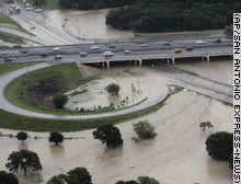

More rain in store for flood-ravaged area
FORT WORTH, Texas (AP) -- Flood-weary residents hoping for a reprieve from the sustained, heavy rains that have soaked parts of Texas may have to wait, as forecasts called for more of the same on Friday.
The storms, which were being blamed for at least 11 deaths in north and central Texas since last week, have swollen rivers and forced the evacuation of thousands of people from their homes.
There was a more than 60 percent chance that the rains would continue in the affected areas Friday, said Jesse Moore, a meteorologist with the National Weather Service in Fort Worth. (Watch the power of a flooded river that moved vehicles and ravaged homes )
A flood watch was in effect for 28 counties until Friday afternoon.
"The storms are very efficient rain producers, and if you happen to be under one of them you can pick up 1½ or 2 inches an hour," Moore said. "Right now with the ground being saturated, it's all run-off and that causes the flash flooding we've been seeing."
Evacuation orders were issued Thursday for about 2,000 residents near the flood-swollen Brazos River in Parker County.
The river was more than 2 feet above its flood stage late Thursday but had gone down nearly a foot by Friday morning. Officials said it could rise again if they opt to open a flood gate at the Possum Kingdom Lake dam to relieve pressure on the dam.
In San Antonio, there were 52 street closures and 43 calls for high-water rescues, although it's unclear how many people were actually rescued, said Sandy Gutierrez, a spokeswoman for San Antonio's Emergency Operations Center. (Interactive: Gallery of dramatic rescues and thankful flood survivors)
Lt. Gov. David Dewhurst, acting governor while Gov. Rick Perry is out of the country, surveyed flood damage Thursday in Marble Falls, which received 19 inches of rain in a six-hour period the previous day.
Despite periods of drizzle, residents began clearing the debris, rubble and mud from the streets.
"We're through the crisis point and now we're at the point it's time to roll up our sleeves and get dirty," Mayor Raymond Whitman said.
Employees worked through the light rainfall to clean up at the Ingram Readymix Inc. plant, which was wrecked by 6 feet of rushing water. Aluminum walls flared from the side of the building, and rubble was piled outside the main office.
"It's not a total loss, but it's pretty much devastating," plant manager Craig Seward said.
Most of the town's 7,200 residents remained without running water after flash floods damaged the city's water treatment plant, which state environmental officials were assessing. Bottled water brought in by state emergency workers was available. (Watch what's in store for Marble Falls )
The flooding caused the closure of six bridges and tore a wall off the funeral home, Whitman said. As many as 150 homes and businesses in the town were damaged, town spokeswoman Christine Laine said.
It's the wettest year on record in Austin, with more than 30 inches of rain since January, and Dallas-Fort Worth, Waco and Wichita Falls have received near-record amounts. The rainfall has more than compensated for a drought that gripped much of Texas in 2005-06, National Weather Service meteorologist Mark Lenz said.
All 77 of Oklahoma's counties were under a state of emergency late Thursday. Officials said 46 homes in Pottawatomie County sustained major damage. Three water rescues were performed Thursday in Kingfisher County in central Oklahoma.
The National Weather Service on Thursday recorded rainfall in Oklahoma City for the 16th straight day, two days longer than the previous record, set from May 29 to June 11 in 1937. Forecasters predicted the rain could continue for several more days.
AUSTIN, Texas — With rivers and lakes filled to the brim and more rain in the forecast, emergency officials in the U.S. state of Texas on Friday braced for more of the flooding that has severely damaged or destroyed 1,000 homes.
July 5: Water from Lake Corpus Christi pours out of several gates at the Lake Corpus Christi Reservoir Wesley Seale Dam near Mathis, Texas
State emergency management chief Jack Colley said all of Texas' major river basins are at flood stage, the first time that has happened since 1957. Major flooding was forecast on the Guadalupe River in Victoria and Calhoun counties, where it was expected to crest near Bloomington at just over 27 feet early Saturday. Flood stage is 20 feet.
"Mostly this time of year we're fighting wildfires ... The problem with this is, the water won't go away," he said Thursday.
• Monitor the situation in FOXNews.com's Natural Disasters Center.
Other areas of concern include the Brazos, Sabine and Trinity rivers and Nueces River near Corpus Christi, Colley said.
Floodwaters slowly subsided Thursday in parts of Oklahoma and Kansas. Concerns eased that a full Lake Texoma along the Oklahoma-Texas line would send floodwaters into the Red River.
The U.S. Army Corps of Engineers said water could spill over the Denison Dam on Friday, flooding areas to the south. Those living in farm areas near the river were told to move their belongings to higher ground and have an evacuation plan.
Early Friday, Lake Texoma's level topped 639 feet, well past its normal elevation of 619 feet and just shy of the top of the spillway — 640 feet, according to the Corps.
"It's still rising but right now, we've been able to handle the flows and minimize the threat for downstream flooding," said Ed Rossman, assistant chief of planning for the Corps.
To the south, storms that began May 23 continued pounding Texas. The National Weather Service said 1 to 3 inches (of rain could fall Friday, with heavier amounts in isolated areas. On Thursday night, rainfall amounts in the past 24 hours included 5 inches (13 centimeters) in coastal Palacios, 2.2 inches at Houston's Hobby Airport and 1.9 inches (4.8 centimeters) in Rockport.
Flash flood warnings were issued overnight for several counties in northern Texas. Flooding washed out a bridge in Anderson County early Friday and authorities closed at least two roads, a dispatcher said. Hunt County also reported road closures.
Michael Gittinger, a meteorologist with the National Weather Service, said a series of low-pressure systems that have hovered over Texas for three weeks, combined with moist bands of air from the Gulf of Mexico, have fueled the near-record rainfall. The system is forecast to move northward through Arkansas and toward the East Coast.
The affected area covers 49 counties and 48,000 square miles from northern Texas to the Rio Grande Valley, a section roughly the size of Greece. Thirteen deaths have been blamed on the weather in the past 2 1/2 weeks in the state, Gov. Rick Perry's office said.
The latest death occurred early Thursday near Clifton in Bosque County, when a car driven by a 37-year-old woman hydroplaned, collided with a curb and plunged into a creek, authorities said.
Four people have been reported missing, including a 6-year-old boy swept into the Gulf of Mexico on Tuesday as strong currents ripped him from his father's arms at the mouth of the Brazos River in Freeport.
In Missouri, the body of a 16-year-old girl was found Wednesday night in a submerged SUV after she apparently tried to cross a flooded creek.
So far, the heaviest flood damage has been in Miami, Oklahoma, where the Neosho River crested at about 29 feet, its highest stage since 1951. The river was not expected to be back within its banks until late Sunday.
About 600 homes and businesses were believed damaged, City Manager Mike Spurgeon said. More than 30 area roads were still closed Thursday.
Spurgeon estimated it could take six months to a year to rebuild in the parts of town most heavily damaged.
Displaced residents watched and waited, anxious to begin salvaging soggy belongings. Dorena Jackson walked near her neighborhood in Miami, Oklahoma, trying to get a glimpse of the home she left two days ago.
"I don't even have a change of clothes," Jackson said. "I lost everything as far as I know."
President Bush has issued federal disaster declarations for numerous counties in Texas, Kansas and Oklahoma, clearing the way for housing assistance and low-interest loans, and more declarations are expected. (FOX)
quote:twitter: BreakingNewsOn: BREAKING NEWS -- Police have blocked off all roads heading to the three New York city-area airports; reason unknown. -- BREAKING NEWS
9:26 PM BreakingNewsOn: Severe weather in the New York area has forced the closure of roads leading to New York city-area airports.
BreakingNewsOn: The National Weather Service confirmed that an F-1 tornado touched down on the Islip area of Long Island, New York; reports of damage.
http://wcbstv.com/watercooler/local_story_199150015.htmlquote:Op woensdag 18 juli 2007 22:06 schreef Frutsel het volgende:
Kan nergens iets vinden over dat bericht Roel
F2 Tornado strikes Brooklyn - First ever!
NEW YORK What was thought to be a violently windy thunderstorm that plowed through Brooklyn Wednesday morning turned out to be a weather event of historical proportions.
The National Weather Service confirmed that the storm brought with it Brooklyn's first ever tornado since such weather events were recorded. Officials measured it to be an EF2 twister, characterized by winds of anywhere from 111 to 135 miles per hour.
Between 4 a.m. and 7 a.m. a string of severe thunderstorms blew through the region, making for an incredible headache for morning commuters. Thousands of New Yorkers found themselves enduring hours of delays in the sweltering heat with subways shut down and vacant taxi cabs hard to come by.
A woman on Staten Island died in a car accident which officials say was a result of the horrible driving conditions. In Brooklyn, amazingly, only scattered minor injuries were reported.
Still, the tornado certainly rattled bones as well as bricks, especially in Bay Ridge.
"About 6:35 this morning it sounded like a freight rain coming down the driveway. The house was shaking and people were screaming," said Linda Mantia, who lives in the Bay Ridge section.
"I just wanted to lay down and die," Brooklyn resident May Johnson told CBS 2.
Eric Casanova couldn't believe what he saw out his window. "I looked out my window and the trees looked like dandelions. They were flowing all over the place," he said. "They say you get 15 minutes of fame, here in Bay Ridge it's 15 minutes of history."
Not only is the tornado the first ever in recorded history to touch down in Brooklyn, it's also the first to hit a New York City borough since 1995, when a twister struck Staten Island.
Outside of those two, there have been only two other tornadoes to strike New York City. The first touched down in Queens in 1985 and the second in Staten Island in 1990.
Record-keeping of tornadoes began nationwide in 1950.
NEW YORK What was thought to be a violently windy thunderstorm that plowed through Brooklyn Wednesday morning turned out to be a weather event of historical proportions.
The National Weather Service confirmed that the storm brought with it Brooklyn's first ever tornado since such weather events were recorded. Officials measured it to be an EF2 twister, characterized by winds of anywhere from 111 to 135 miles per hour.
Between 4 a.m. and 7 a.m. a string of severe thunderstorms blew through the region, making for an incredible headache for morning commuters. Thousands of New Yorkers found themselves enduring hours of delays in the sweltering heat with subways shut down and vacant taxi cabs hard to come by.
A woman on Staten Island died in a car accident which officials say was a result of the horrible driving conditions. In Brooklyn, amazingly, only scattered minor injuries were reported.
Still, the tornado certainly rattled bones as well as bricks, especially in Bay Ridge.
"About 6:35 this morning it sounded like a freight rain coming down the driveway. The house was shaking and people were screaming," said Linda Mantia, who lives in the Bay Ridge section.
"I just wanted to lay down and die," Brooklyn resident May Johnson told CBS 2.

Eric Casanova couldn't believe what he saw out his window. "I looked out my window and the trees looked like dandelions. They were flowing all over the place," he said. "They say you get 15 minutes of fame, here in Bay Ridge it's 15 minutes of history."
Not only is the tornado the first ever in recorded history to touch down in Brooklyn, it's also the first to hit a New York City borough since 1995, when a twister struck Staten Island.
Outside of those two, there have been only two other tornadoes to strike New York City. The first touched down in Queens in 1985 and the second in Staten Island in 1990.
Record-keeping of tornadoes began nationwide in 1950.

Doden bij overstromingen in binnenland VS
(Novum/AP) - In de Amerikaanse staten Minnesota en Wisconsin hebben zware stormen in combinatie met hevige regenval in de nacht van zaterdag op zondag voor veel overlast gezorgd. Minstens vier mensen kwamen om het leven door overstromingen, die bruggen en wegen wegspoelden.
De slachtoffers vielen in Minnesota bij de plaatsen Stockton en Wikota, toen in twee gevallen de inzittenden van een auto verdronken omdat zij door het snel stijgende water geen kans meer zagen om uit hun voertuig te komen. In Wisconsin zorgde dertig centimeter regen voor een modderstroom die een huis meevoerde en midden op de rijksweg achterliet. Bruggen en wegen werden vanwege de regen afgesloten en enkele dorpen zijn zondag ontruimd, meldden de autoriteiten.
bron:
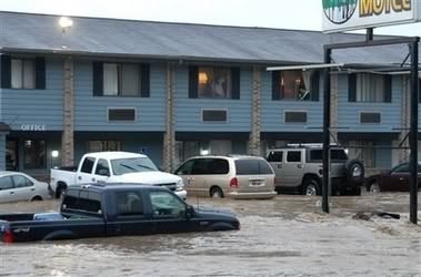
Deadly Storm Flooding Soaks Ohio After Drenching Upper Midwest - kills 21
RUSHFORD, Minn. — A powerful storm system that swamped the upper Midwest and killed at least six people moved into Ohio on Tuesday as weary Minnesota residents returned to their water-logged homes. For many, it was a surreal scene.
Orange Xs marked buildings that had been searched for survivors. Canoes lay in the streets. At a campground in Houston County, picnic tables hung from trees.
Mud several inches deep covered streets in parts of Rushford, and some sidewalks had collapsed.
"Some people had to cut holes in their roofs to get out, the water was so deep," said Jack O'Donnell, chief deputy with the Fillmore County Sheriff's Office.
The storm was one of two systems that flooded towns in the Midwest and southern Plains over the weekend. The second, the remnants of Tropical Storm Erin, killed six people in Oklahoma, eight in Texas and one in Missouri, where up to 11 inches of rain fell in a few hours Monday.
Tuesday morning, heavy rain in Ohio caused flooding that closed a seven-mile stretch of Interstate 75 in the northwest part of the state, the Highway Patrol said.
Nearby, motorists were urged to stay out of Wyandot County because of extensive flooding caused by more than 8 inches of rain, and authorities were busy rescuing motorists from stalled cars, sheriff's Lt. Neil Riedlinger said.
Water was 3 feet deep Tuesday in downtown Carey, Ohio, and a local nursing home had to be evacuated, Riedlinger said. Firefighters in the north-central Ohio town of Bucyrus used a boat to rescue families from flooded homes.
In Minnesota, divers and the crew of a National Guard helicopter searched for Jered Lorenz, 37, whose overturned car was found lodged in the rocks along a creek near Lewiston.
Fifteen miles to the south, the National Guard controlled access to the city of Rushford, escorting residents in just long enough for them to grab pets, clothing, medicine and other emergency supplies.
Rushford City administrator Windy Block said residents may be allowed back for good Tuesday if electrical power is restored and the storm sewer works. She estimated that at least a third of the town's 1,800 residents suffered damage from the flooding of Rush Creek.
Hundreds of people fled their homes in southwestern Wisconsin as the deluge turned the countryside in Vernon, Crawford and Richland counties into bogs, drowned crops and strained dams nearly to the breaking point. Damage estimates hit nearly $30 million and were expected to keep climbing.
Southwestern Wisconsin was under another flash flood watch Tuesday night and Wednesday, with a chance of rain through Friday, said National Weather Service meteorologist Rod Swerman.
The town of Soldiers Grove, Wis., lost part of a road to flooding. In nearby Gays Mills, flooding filled downtown with waist-deep, peanut butter-colored water. Mason Evans Jr. said water was 8 feet deep in his house in Gays Mills.
"It broke me," Evans said. "I lost everything." (FOX)
RUSHFORD, Minn. — A powerful storm system that swamped the upper Midwest and killed at least six people moved into Ohio on Tuesday as weary Minnesota residents returned to their water-logged homes. For many, it was a surreal scene.
Orange Xs marked buildings that had been searched for survivors. Canoes lay in the streets. At a campground in Houston County, picnic tables hung from trees.

Mud several inches deep covered streets in parts of Rushford, and some sidewalks had collapsed.
"Some people had to cut holes in their roofs to get out, the water was so deep," said Jack O'Donnell, chief deputy with the Fillmore County Sheriff's Office.
The storm was one of two systems that flooded towns in the Midwest and southern Plains over the weekend. The second, the remnants of Tropical Storm Erin, killed six people in Oklahoma, eight in Texas and one in Missouri, where up to 11 inches of rain fell in a few hours Monday.
Tuesday morning, heavy rain in Ohio caused flooding that closed a seven-mile stretch of Interstate 75 in the northwest part of the state, the Highway Patrol said.
Nearby, motorists were urged to stay out of Wyandot County because of extensive flooding caused by more than 8 inches of rain, and authorities were busy rescuing motorists from stalled cars, sheriff's Lt. Neil Riedlinger said.
Water was 3 feet deep Tuesday in downtown Carey, Ohio, and a local nursing home had to be evacuated, Riedlinger said. Firefighters in the north-central Ohio town of Bucyrus used a boat to rescue families from flooded homes.
In Minnesota, divers and the crew of a National Guard helicopter searched for Jered Lorenz, 37, whose overturned car was found lodged in the rocks along a creek near Lewiston.
Fifteen miles to the south, the National Guard controlled access to the city of Rushford, escorting residents in just long enough for them to grab pets, clothing, medicine and other emergency supplies.
Rushford City administrator Windy Block said residents may be allowed back for good Tuesday if electrical power is restored and the storm sewer works. She estimated that at least a third of the town's 1,800 residents suffered damage from the flooding of Rush Creek.
Hundreds of people fled their homes in southwestern Wisconsin as the deluge turned the countryside in Vernon, Crawford and Richland counties into bogs, drowned crops and strained dams nearly to the breaking point. Damage estimates hit nearly $30 million and were expected to keep climbing.
Southwestern Wisconsin was under another flash flood watch Tuesday night and Wednesday, with a chance of rain through Friday, said National Weather Service meteorologist Rod Swerman.
The town of Soldiers Grove, Wis., lost part of a road to flooding. In nearby Gays Mills, flooding filled downtown with waist-deep, peanut butter-colored water. Mason Evans Jr. said water was 8 feet deep in his house in Gays Mills.
"It broke me," Evans said. "I lost everything." (FOX)


Noodweer Centraal VS
In de Amerikaans staten Nebraska, Iowa, Illinois en Ohio zijn zeker acht mensen omgekomen door zware regenval. Dat hebben de lokale autoriteiten woensdag gezegd. Vooral de staat Ohio is zwaar getroffen. In negen districten in het noordelijk deel is de noodtoestand uitgeroepen. Volgens reddingswerkers zijn het de zwaarste overstromingen in zeker dertig jaar. Honderden mensen zijn geëvacueerd. Huizen zijn ondergelopen en straten stonden blank.
Eerder werden de zuidelijker gelegen staten Oklahoma en Texas al geteisterd door overstromingen. Hier kwamen het afgelopen weekeinde twintig mensen om. Het slechte weer kwam van overblijfselen van de tropische storm Erin.
't Gaat tot nu toe net onder Michigan door, alhoewel er de laatste week wel enorme stormen en onweersbuien zijn geweest. Voor een mooi schouwspel in de lucht zit je hier op de goede plek. De onweersbuien hier zijn 'beroemd', of beter, berucht.
GRAND RAPIDS - Where there's a boom, there's a flash, and it's important to be ready.
According to the National Weather Service, lightning kills an average of 80 people each year, and injures another 300.
Even when a thunderstorm is 20 miles away, it is still possible to be injured, even killed by lightning.
Michigan is the #2 state, behind just Florida, in the nation for deaths and injuries due to lightning.
De nummer twee staat in de VS met doden dmv bliksem.
Patience is not one of my virtues, neither is memory. Or patience for that matter.

Severe Storms Across the Great Plains
A line of powerful, drenching storms snaked across the upper Great Plains of the United States in the third full week of August 2007, while the remnants of Tropical Storm Erin drenched the already-sodden Southern Plains.
This image from the near-real-time, Multi-satellite Precipitation Analysis (MPA) project at NASA’s Goddard Space Flight Center shows rain accumulations between August 10 and August 20, 2007, across the central and eastern United States. Based in part on observations form the Tropical Rainfall Measuring Mission (TRMM) satellite, the MPA shows that some areas of Wisconsin and Minnesota received more than 500 millimeters of rain (dark red) during the stormy period—even more rain than Texas and Oklahoma received from the passage of Tropical Storm Erin.
Between August 21-22, these two storm systems collided in the Great Lakes and Ohio Valley areas and unleashed huge amount of rain. Flash flooding, strong winds, and tornadoes also occurred in many states, and more than 20 people were killed, according to news reports.
Dodental VS door extreem weer stijgt
CHICAGO - Extreme weersomstandigheden in de Verenigde Staten hebben de afgelopen dagen tientallen personen het leven gekost.
Het aantal slachtoffers door overstromingen en stormen steeg donderdag naar 23. Een hittegolf met recordtemperaturen in het midden van de VS eiste al zeker 25 levens.
Onder de recente slachtoffers van de extreme omstandigheden zijn drie personen die in Wisconsin door de bliksem werden getroffen. Het gaat om een vrouw, haar kind en een man. Zij werden geëlektrocuteerd door een stroomkabel die was geknapt na een blikseminslag. De kabel viel in een plas water waarin zij op de bus stonden te wachten.
Nu.nl
En nog meer tornadowaarschuwingen op het lokale nieuws, de dichtsbijzijnde is 15 kilometer hier vandaan.
Patience is not one of my virtues, neither is memory. Or patience for that matter.
Video van 'tornado touchdown' op het lokale nieuws.
Tornado touches down twice in Montcalm Co.
Dat was hier dus vlakbij.
Tot zo ver uw reporter ter plekke, nog een goedenavond.

Tornado touches down twice in Montcalm Co.
Dat was hier dus vlakbij.
Tot zo ver uw reporter ter plekke, nog een goedenavond.
Patience is not one of my virtues, neither is memory. Or patience for that matter.
Ik zag het gisteren op CNN. Hm??? In Nederland heb ik er nog niets over gelezen, terwijl het categorie 'Engeland onder water' is met tientallen doden.
Gisteren lieten ze er wel wat over zien bij 1 van de journaals.quote:Op vrijdag 24 augustus 2007 15:48 schreef Monidique het volgende:
Ik zag het gisteren op CNN. Hm??? In Nederland heb ik er nog niets over gelezen, terwijl het categorie 'Engeland onder water' is met tientallen doden.
lightning light up the Chicago skyline
[ Bericht 1% gewijzigd door #ANONIEM op 24-08-2007 17:47:33 ]
Schande!quote:Op vrijdag 24 augustus 2007 15:48 schreef Monidique het volgende:
Ik zag het gisteren op CNN. Hm??? In Nederland heb ik er nog niets over gelezen, terwijl het categorie 'Engeland onder water' is met tientallen doden.
Ach ja, hier is het af en toe weer teveel van het goede. Al moet ik zeggen met zulk weer kijk ik graag lokale tv.
Patience is not one of my virtues, neither is memory. Or patience for that matter.
COLUMBUS, Ohio — Beleaguered residents of the flood-ravaged Midwest found fresh damage Sunday from a batch of tornado-bearing thunderstorms that knocked out power to hundreds of thousands of customers.
Tornado warnings were issued Saturday afternoon for parts of central and southeast Ohio. Downed trees and power lines were reported in the southern part of the state, said National Weather Service meteorologist Andy Hatzos.
Flooding this past week spread across an 80-mile swath through the northwest and north central parts of the state. Gov. Ted Strickland was to tour more of the damaged areas Sunday.
"What I've tried to do and what we've all tried to do is let these folks know ... that we are working to get assistance to them as rapidly as possible," Strickland said Saturday.
Powerful storms rolling through the Upper Midwest during most of the past week caused disastrous floods from southeastern Minnesota to Ohio that were blamed for at least 18 deaths.
In southern Michigan, about 42,000 customers still lacked power Sunday, utilities said. The weather service confirmed tornadoes touched down Friday in at least six areas of the state. One of the twisters cut a path a quarter-mile wide, snapping and uprooting hundreds of trees, the weather service said.
Five people were reported injured in Michigan's Eaton County. A dozen homes were destroyed and seven were heavily damaged, Sheriff Mike Raines said.
Damage in Fenton, Mich., was extensive, Mayor Sue Osborn said Saturday. "I have seen houses that have trees go right through them," she said. Only residents were being allowed into the city, she said.
Matt McClanahan's home in Michigan's Cohoctah Township was among at least 17 destroyed by a twister.
"I've seen devastation and I've helped clean up, but I've never seen it be me," he said. "I bought a bottle of Jim Beam and it's in the house. I could really use a sip of that right now."
Power had been restored to nearly 600,000 customers in northern Illinois since Thursday's storm, but it could take days to restore power to tens of thousands more, officials said.
The storms in Illinois were responsible for at least one death, a man struck by a wind-toppled tree, officials said.
Flooding in Wisconsin destroyed 44 homes and damaged more than 1,400, most of them in the southwestern part of the state. Officials in Vernon County lifted evacuation orders Saturday evening, allowing the return of 140 residents displaced after torrential rainfall strained a number of nearby dams.
About 1,500 homes were damaged around Minnesota. Federal Emergency Management Agency Administrator R. David said FEMA recovery centers should be running early this week in the three counties where President Bush declared disasters.
Bron -> http://www.foxnews.com/story/0,2933,294591,00.html
Tornado warnings were issued Saturday afternoon for parts of central and southeast Ohio. Downed trees and power lines were reported in the southern part of the state, said National Weather Service meteorologist Andy Hatzos.

Flooding this past week spread across an 80-mile swath through the northwest and north central parts of the state. Gov. Ted Strickland was to tour more of the damaged areas Sunday.
"What I've tried to do and what we've all tried to do is let these folks know ... that we are working to get assistance to them as rapidly as possible," Strickland said Saturday.
Powerful storms rolling through the Upper Midwest during most of the past week caused disastrous floods from southeastern Minnesota to Ohio that were blamed for at least 18 deaths.
In southern Michigan, about 42,000 customers still lacked power Sunday, utilities said. The weather service confirmed tornadoes touched down Friday in at least six areas of the state. One of the twisters cut a path a quarter-mile wide, snapping and uprooting hundreds of trees, the weather service said.
Five people were reported injured in Michigan's Eaton County. A dozen homes were destroyed and seven were heavily damaged, Sheriff Mike Raines said.
Damage in Fenton, Mich., was extensive, Mayor Sue Osborn said Saturday. "I have seen houses that have trees go right through them," she said. Only residents were being allowed into the city, she said.
Matt McClanahan's home in Michigan's Cohoctah Township was among at least 17 destroyed by a twister.
"I've seen devastation and I've helped clean up, but I've never seen it be me," he said. "I bought a bottle of Jim Beam and it's in the house. I could really use a sip of that right now."
Power had been restored to nearly 600,000 customers in northern Illinois since Thursday's storm, but it could take days to restore power to tens of thousands more, officials said.
The storms in Illinois were responsible for at least one death, a man struck by a wind-toppled tree, officials said.

Flooding in Wisconsin destroyed 44 homes and damaged more than 1,400, most of them in the southwestern part of the state. Officials in Vernon County lifted evacuation orders Saturday evening, allowing the return of 140 residents displaced after torrential rainfall strained a number of nearby dams.
About 1,500 homes were damaged around Minnesota. Federal Emergency Management Agency Administrator R. David said FEMA recovery centers should be running early this week in the three counties where President Bush declared disasters.
Bron -> http://www.foxnews.com/story/0,2933,294591,00.html
Severe storms injure more then 30 in Tulsa
OKLAHOMA CITY — More than 30 people were hurt and more than two dozen mobile homes and travel trailers were damaged as severe thunderstorms raked across Oklahoma on Wednesday, authorities said.
At least 30 people were injured when a strong storm moved through the Tulsa area, causing two tents to collapse during an Oktoberfest festival just before 7:30 p.m.
"There was some sort of tornado or microburst that picked up at least one of the tents and it collapsed on a large group of people," said Tulsa police Sgt. Michael Brown.
Brown said there were about 30 injuries reported, but more people left on their own to seek treatment.
"Of these, it looks like five were treated and released, 24 were transported and one was transported in critical condition," Brown said.
North of Tulsa, five people were injured and 25 mobile homes and travel trailers were damaged when a storm hit a mobile home park between Oologah and the Washington County line, the Oologah-Talala Emergency Medical Services District reported.
Four of the injured were in a mobile home that was destroyed, and the fifth was a woman who was hit by debris, officials said. None of the injuries was believed to be life threatening, officials said.
Bob Anderson, Rogers County Emergency Management director, said besides the mobile home that was destroyed, a smaller trailer was rolled over. The other units at the park appeared to have been damaged, but officials wouldn't know the extent until daylight, Anderson said.
There also were reports of crews trying to rescue people trapped between downed power lines in Woodall in Cherokee County, authorities said. Semi trucks were blown over on U.S. 69 in Pryor and at the toll gate on the Muskogee Turnpike near Coweta, according to reports.
Downed trees and power lines also were reported in Rogers and Mayes counties, authorities said.
The storms also knocked out electric power to 1,564 Oklahoma Gas and Electric customers in northeastern Oklahoma and more than 3,700 in western Arkansas, according to OG&E's Web site.
The storms were part of a powerful, spring-like system that brought heavy rain, high winds, hail and a possible tornado to Oklahoma.
Storm spotters in Kingfisher County, northwest of Oklahoma City, reported seeing a tornado touch down about 9:30 a.m. Wednesday about a mile west of Kingfisher, Emergency Management Director Steve Loftis said. No damage was reported, Loftis said.
"An 86-mph wind gust came through about 8:15 this morning," he said. "And we had some localized street flooding — just the same streets that always flood when it rains. As of 2 p.m., we had close to 2.2 inches of rain."
The weather service has not confirmed the tornado.
Other high-wind reports included a 73-mph gust at Weatherford and a 62-mph gust in west Tulsa, according to the weather service.
http://www.foxnews.com/story/0,2933,303060,00.html
Mogelijk 2 doden door tornado VS
In de Verenigde Staten zijn woensdag op uitgebreide schaal tornado’s voorgekomen. Daarbij zijn twee mensen om het leven gekomen.
Of de twee daadwerkelijk om het leven kwamen ten gevolge van de passage van een tornado of van hevige windstoten is nog onbekend. Meteorologen zullen dit de komende weken onderzoeken.
In totaal werden woensdag 15 tornado’s waargenomen. Vooral in Missouri, maar ook langs de zuidkust kwamen de tornado voor. Vooral deze zuidkust kan de komende anderhalve maand nog het een en ander verwachten. Hier vindt dan een tweede, maar wel kleinere, tornadoseizoen plaats.
vwk

A tornado pummeled Pensacola, Florida, Thursday, severely damaging a church with an attached day care center, destroying homes and leaving thousands of homes and businesses without power, the mayor said.
"We had about 15 or 20 minutes notice from the weather service that Doppler radar indicated that there was, in fact, a rotation in this one severe thunderstorm," Mayor John Fogg said.
"We aren't used to tornadoes in this area."
The day care center next to the Greater Little Rock Baptist Church "took a direct hit," but the children already had been moved to a safer location, said Glenn Austin, spokesman for the Escambia County Sheriff's Office.
Video showed frantic, tearful parents rushing into the building to get their children.
Christie Fayard said she and her co-workers saw the tornado from their building about two miles away.
"We took cover. We just went to a break room and let it pass," said Fayard, who is the sister of CNN correspondent Ed Lavandera.
After the storm passed, Fayard left work and saw a vehicle overturned in a Target store parking lot.
"We had ample warning," Fayard said. "I think the local media did a great job [warning people]."
Another Pensacola resident who saw the twister pass said it made a frightening noise.
"It sounded creepy, like a bunch of cars were driving over my house," Leeann Franzonne told The Associated Press.

The tornado was spotted about 9 a.m. and dissipated about 40 minutes later, Austin said. It moved roughly from southwest to northeast, with the biggest apparent damage in the southwest, where older suburbs are located.

http://edition.cnn.com/20(...)st.storms/index.html
Tornado's do death and destruction in Missouri, Florida and Michigan
orms that raked the Plains and Southeast on Thursday tossed a mobile home in Missouri, killing both people inside, and spawned a tornado in Florida that sent mall shoppers and children at a day care center running for cover.
The storms continued throughout the day, pelting downtown Chicago with hail during the evening rush hour and spawning tornadoes in Kentucky and Michigan as they swept eastward, officials said.
In rural northeastern Missouri, the state Highway Patrol said Kent Ensor and Kristy Secrease had sought refuge in Secrease's mobile home in Monroe County as a tornado approached. Their bodies were found about 400 feet from where the home had been.
The mobile home's frame was found three-quarters of a mile away, with debris as far as two miles away. The National Weather Service said the storm traveled a mile and had winds as high as 135 mph.
Ensor, 44, and Secrease, 25, had been dating for about a year, friends and family members said.
"Everybody knows everybody here," said Jim Lovelady, who moved to the Paris area in 1994. "This hurts."
A line of storms ripped through northern Michigan on Thursday night, destroying several homes, overturning vehicles and leaving at least one person dead, authorities said.
he 29-year-old victim was trapped inside his house after strong winds took the structure down around him, WWTV-TV in Cadillac, Mich., reported. Kalkaska County sheriff's deputies confirmed the death, and said a couple trapped in another demolished house was taken to the hospital.
National Weather Service officials said at least one and as many as five tornadoes touched down in Michigan. Outside of Lansing, seven homes in Shiawassee County were damaged and a semi-trailer traveling along Interstate 96 reportedly flipped, authorities said. Police could not immediately provide information about the driver's injuries.
A tornado Thursday morning in Pensacola, Fla., damaged the city's major shopping mall.
Eddie English Jr., a department store stock manager, said he heard the wind outside the store suddenly speed up and get louder. Then mall security guards entered the store and ordered 200 to 300 employees and shoppers into the basement.
Lindsey Lassiter, manager of the mall's Express for Men store, said water poured in from her shop's damaged ceiling. In downtown Pensacola, electricity was out and streets filled up with several inches of water from rain that began around dawn.
Greater Little Rock Baptist Church's roof was damaged, as was its day care center, said Escambia County sheriff's spokesman Glenn Austin. But the children there had been moved to safety before the tornado struck, he said.
"They heard the warnings, grabbed the kids and followed the drill," he said.
Jack Cullen, a meteorologist with the National Weather Service, confirmed that a tornado touched down shortly before noon.
High winds injured three people in Arkansas on Wednesday, the state Department of Emergency Management said. A tornado also destroyed five mobile homes and damaged four houses, state and weather officials said.
The severe weather continued into the night. Thunderstorms injured four people in a mobile home west of Louisville, Ky., said Capt. Jeff Jones of the Daviess County Sheriff's Office. The nature of their injuries was not immediately available.
Four more people were hurt when a mobile home in Sebree, Ky., collapsed because of strong winds, state police said. Their injuries appeared to be minor, Webster County Sheriff Frankie Springfield told The Gleaner of Henderson, Ky.
Possible tornadoes were also reported Thursday night in Illinois and Indiana. Winds reached 80 mph in New Amsterdam, Ind., said Larry Dattilo of the National Weather Service.
A sudden downpour belted downtown Chicago just as people left work, sending commuters scurrying into buildings to avoid strong winds, hail and horizontal rain. The city's two major airports reported delays of two hours.
An 11-year-old boy was in stable condition after being struck by lightning, said Chicago Fire Department spokesman Larry Langford.
To the West, a separate system brought the season's first big storm to coastal Washington, where a falling tree injured a woman and more than 220,000 customers lost power at the height of the storm. A gust of 62 mph was reported in Spanaway, said Weather Service meteorologist Carl Cerniglia.
The night before in Tulsa, Okla., more than 7,000 people were at the Oktoberfest festival when the tents collapsed. Five of those hurt remained hospitalized Thursday, and three were in serious condition with head injuries, concussions and lacerations, said Tina Wells, spokeswoman for the Emergency Medical Services Authority.
North of Tulsa, five people were injured and 25 mobile homes and travel trailers were damaged when the storm hit a mobile home park between Oologah and the Washington County line, the Oologah-Talala Emergency Medical Services District reported. None of the injuries was believed to be life-threatening, officials said.
orms that raked the Plains and Southeast on Thursday tossed a mobile home in Missouri, killing both people inside, and spawned a tornado in Florida that sent mall shoppers and children at a day care center running for cover.
The storms continued throughout the day, pelting downtown Chicago with hail during the evening rush hour and spawning tornadoes in Kentucky and Michigan as they swept eastward, officials said.
In rural northeastern Missouri, the state Highway Patrol said Kent Ensor and Kristy Secrease had sought refuge in Secrease's mobile home in Monroe County as a tornado approached. Their bodies were found about 400 feet from where the home had been.
The mobile home's frame was found three-quarters of a mile away, with debris as far as two miles away. The National Weather Service said the storm traveled a mile and had winds as high as 135 mph.
Ensor, 44, and Secrease, 25, had been dating for about a year, friends and family members said.
"Everybody knows everybody here," said Jim Lovelady, who moved to the Paris area in 1994. "This hurts."
A line of storms ripped through northern Michigan on Thursday night, destroying several homes, overturning vehicles and leaving at least one person dead, authorities said.


he 29-year-old victim was trapped inside his house after strong winds took the structure down around him, WWTV-TV in Cadillac, Mich., reported. Kalkaska County sheriff's deputies confirmed the death, and said a couple trapped in another demolished house was taken to the hospital.
National Weather Service officials said at least one and as many as five tornadoes touched down in Michigan. Outside of Lansing, seven homes in Shiawassee County were damaged and a semi-trailer traveling along Interstate 96 reportedly flipped, authorities said. Police could not immediately provide information about the driver's injuries.
A tornado Thursday morning in Pensacola, Fla., damaged the city's major shopping mall.
Eddie English Jr., a department store stock manager, said he heard the wind outside the store suddenly speed up and get louder. Then mall security guards entered the store and ordered 200 to 300 employees and shoppers into the basement.
Lindsey Lassiter, manager of the mall's Express for Men store, said water poured in from her shop's damaged ceiling. In downtown Pensacola, electricity was out and streets filled up with several inches of water from rain that began around dawn.
Greater Little Rock Baptist Church's roof was damaged, as was its day care center, said Escambia County sheriff's spokesman Glenn Austin. But the children there had been moved to safety before the tornado struck, he said.
"They heard the warnings, grabbed the kids and followed the drill," he said.
Jack Cullen, a meteorologist with the National Weather Service, confirmed that a tornado touched down shortly before noon.
High winds injured three people in Arkansas on Wednesday, the state Department of Emergency Management said. A tornado also destroyed five mobile homes and damaged four houses, state and weather officials said.
The severe weather continued into the night. Thunderstorms injured four people in a mobile home west of Louisville, Ky., said Capt. Jeff Jones of the Daviess County Sheriff's Office. The nature of their injuries was not immediately available.
Four more people were hurt when a mobile home in Sebree, Ky., collapsed because of strong winds, state police said. Their injuries appeared to be minor, Webster County Sheriff Frankie Springfield told The Gleaner of Henderson, Ky.
Possible tornadoes were also reported Thursday night in Illinois and Indiana. Winds reached 80 mph in New Amsterdam, Ind., said Larry Dattilo of the National Weather Service.
A sudden downpour belted downtown Chicago just as people left work, sending commuters scurrying into buildings to avoid strong winds, hail and horizontal rain. The city's two major airports reported delays of two hours.
An 11-year-old boy was in stable condition after being struck by lightning, said Chicago Fire Department spokesman Larry Langford.
To the West, a separate system brought the season's first big storm to coastal Washington, where a falling tree injured a woman and more than 220,000 customers lost power at the height of the storm. A gust of 62 mph was reported in Spanaway, said Weather Service meteorologist Carl Cerniglia.
The night before in Tulsa, Okla., more than 7,000 people were at the Oktoberfest festival when the tents collapsed. Five of those hurt remained hospitalized Thursday, and three were in serious condition with head injuries, concussions and lacerations, said Tina Wells, spokeswoman for the Emergency Medical Services Authority.
North of Tulsa, five people were injured and 25 mobile homes and travel trailers were damaged when the storm hit a mobile home park between Oologah and the Washington County line, the Oologah-Talala Emergency Medical Services District reported. None of the injuries was believed to be life-threatening, officials said.
Weet niet of het in dit topic hoort, maar Georgia heeft de noodtoestand afgekondigd ivm aanhoudende droogte...
tornado's
het meest spectaculaire/ bizarre weer wat we in NL zien is dat de zon vol schijnt, maar het toch teringkoud is. Dat is toch zeker 2 á 3 dagen t geval geweest deze zomer
voor de rest jammer dat het een oud topic is
het meest spectaculaire/ bizarre weer wat we in NL zien is dat de zon vol schijnt, maar het toch teringkoud is. Dat is toch zeker 2 á 3 dagen t geval geweest deze zomer
voor de rest jammer dat het een oud topic is

NEW ORLEANS — The Army Corps of Engineers closed a gate on a suburban canal as heavy rains lashed the flood-prone city, raising fears that climbing waters threatened to top the walls holding them back.
After more than 8 inches of rain fell on parts of New Orleans by late afternoon, Mayor Ray Nagin shut City Hall early, and schools also closed. People were asked to stay indoors until the flood potential subsided. More rain was expected overnight.
The Harvey Canal in Jefferson Parish was one of several in the area placed under new safety guidelines after Hurricane Katrina's flood waters breached two New Orleans canals in August 2005, causing catastrophic flooding.
The corps has worked to strengthen the canal, about five miles from downtown, but engineers worried that water being driven into it might lead to flooding. The area around the canal includes homes and businesses.
Unlike the canal walls that broke during Katrina, the walls on the Harvey Canal are not considered at threat of being breached by rising waters, said Chris Accardo, the corps' operations chief.
http://www.foxnews.com/story/0,2933,304241,00.html
Hurricane Force Winds Cut Power to Thousands in Pacific Northwest
SEATTLE — Winds gusting at hurricane force in some places Monday left more than 125,000 customers without electricity across the Pacific Northwest and blew the roof off an Oregon firehouse, authorities said.
Winds higher than 70 mph blew trees and branches onto power lines and cut electricity to roughly 85,000 customers in Washington, mostly in the western part of the state.
The region's largest utility, Puget Sound Energy, had about 37,000 customers in the dark in nine counties, spokeswoman Christina Mills said. In Oregon, more than 43,000 customers lost power, utilities reported.
Gusts reported by the National Weather Service by noon included 71 mph at Hoquiam in western Washington and 41 at Seattle-Tacoma International Airport.
The roof blew off the fire station in Gearhart in western Oregon. Cape Meares, on Oregon's north coast, registered a gust of 92 mph, the National Weather Service reported.
Utilities generally consider one home or business a customer, so the number of individuals without power could be much higher.
Fog, rain and sleet led rescue teams to call off intensive efforts to find University of Oregon mathematics professor Daming Xu, 63, believed to be missing in the foothills of the Cascade Range. He was last seen Nov. 4.
http://www.foxnews.com/story/0,2933,311058,00.html
Troops use rafts to evacuate flooded town
PORTLAND, Oregon (AP) -- National Guard troops evacuated residents in a flooded town and tens of thousands of people remained without power Tuesday after back-to-back storms pounded the Pacific Northwest, killing five people.
Troops with the Oregon Air National Guard used inflatable rafts to evacuate flooded residents in Vernonia, a mountain timber town on the Nehalem River, about 35 miles northwest of Portland.
"They're moving down the streets, and through the backyards," said Maj. Mike Braibish, spokesman for the National Guard.
Vernonia, which has about 2,200 residents, had been largely cut off by landslides that blocked roads into the community, but Guard trucks with high clearance were able to get in late Monday and more were being sent, Braibish said. Watch floodwaters rising in Vernonia »
Still, communications were difficult. "There are no phone lines or land lines available in Vernonia," said Hyla Ridenour, spokeswoman for Columbia River Fire and Rescue in nearby St. Helens.
The storm that hit Monday smacked the region with hurricane-force winds and several inches of rain, and was blamed for five deaths in Oregon and Washington state. It came only a day after another severe system moved through Sunday.
By Tuesday, the second system had moved on to the Upper Plains and Midwest, where it was predicted to bring new snow. In North Dakota, the National Weather Service said parts of the state could get up to 9 inches of snow.
Towns on the coast were hit hardest by the storms. Red Cross shelters in western Oregon were housing 556 people as of midnight, said spokeswoman Lise Harwin.
The governors of Washington and Oregon declared states of emergency, which could speed relief efforts in flood-hit areas. The National Weather Service said 3 to 6 inches of rain had fallen across much of western Washington. The 24-hour rain total for Bremerton, Washington, was 10.78 inches.
In Washington, some 130 people had to be rescued from flooded areas by Coast Guard helicopters. Mudslides and floods blocked roads, and Interstate 5, the principal north-south route along the West Coast, was closed near Centralia because of about 3 feet of water over the road. Many schools and government offices were closed for a second day.
cnn
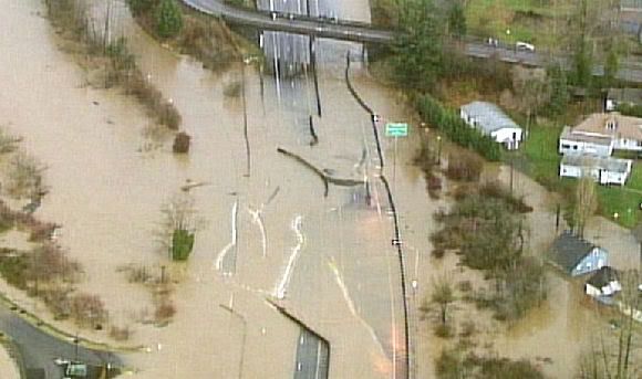

Storm in the Pacific Northwest
A series of powerful storms drenched the Pacific Northwest between November 28 and December 4, 2007. The storms brought hurricane-force winds with gusts greater than 190 kilometers per hour (120 miles per hour) and drenching rain. The heavy rain caused floods and landslides that closed roads, including Interstate 5, and trapped hundreds, reported the Associated Press.
This image shows rainfall totals as recorded by the Multisatellite Precipitation Analysis (MPA) at NASA Goddard Space Flight Center. The heaviest rain is depicted in dark red, while areas of relatively light rain are blue. As this image shows, the bulk of the rain was concentrated on western Washington’s Olympic Peninsula, where the Multisatellite Precipitation Analysis recorded more than 150 millimeters (6 inches) of rain. Bremerton, Washington, located on the western shore of Puget Sound (immediately across the sound from Seattle), saw 10.78 inches of rain, said the Associated Press.
Floods plague Northwest
CHEHALIS, Washington (AP) -- The drenching rain and howling wind were gone but flooding concerns persisted Wednesday as anxious residents waited for water to recede so they could see what was left after this week's fierce storm.
The storm, which killed at least seven people in the Pacific Northwest before moving on Tuesday, left behind flooded homes, fallen trees and washed-out roads, including the region's largest highway.
On Wednesday, the storm continued pushing east, dumping snow across the Midwest, and was blamed for two traffic deaths in Wisconsin.
Damage could be in the billions of dollars, Gov. Chris Gregoire said Wednesday.
She said she was pushing to deliver a damage estimate to the Federal Emergency Management Agency and expected a presidential emergency declaration that could speed delivery of food, medicine and other humanitarian supplies.
At least 300 people had been rescued by helicopters from the Navy, Coast Guard, National Guard and other agencies, and flights continued in what Gregoire described as the state's largest aerial search-and-rescue operation in a decade.
"Those folks who are literally homeless today still have a spirit in them," Gregoire said. "They are determined to get back to their homes and get their lives back together again."
Some people spent Wednesday looking for the lost. In the Lewis County town of Winlock, divers planned to search normally tiny Wallers Creek for Richard Hiatt, 81, believed to have been swept away when a bank gave out from underneath him.
"It happened so quickly," daughter-in-law Sharon Hiatt said Tuesday. "That's the only possibility, that he fell into the creek."
At least half of downtown Aberdeen had electricity Wednesday and Grays Harbor Community Hospital no longer had to rely on emergency generators, said Aberdeen police Detective George J. Kelly. Tens of thousands were without power in Oregon and Washington state at the height of the storm.
National Guard troops were summoned early Wednesday to help evacuate a 20-unit trailer park near Elma threatened by the flooding Chehalis River, Kelly said
cnn
[ Bericht 1% gewijzigd door #ANONIEM op 05-12-2007 21:34:19 ]
CHEHALIS, Washington (AP) -- The drenching rain and howling wind were gone but flooding concerns persisted Wednesday as anxious residents waited for water to recede so they could see what was left after this week's fierce storm.
The storm, which killed at least seven people in the Pacific Northwest before moving on Tuesday, left behind flooded homes, fallen trees and washed-out roads, including the region's largest highway.
On Wednesday, the storm continued pushing east, dumping snow across the Midwest, and was blamed for two traffic deaths in Wisconsin.
Damage could be in the billions of dollars, Gov. Chris Gregoire said Wednesday.
She said she was pushing to deliver a damage estimate to the Federal Emergency Management Agency and expected a presidential emergency declaration that could speed delivery of food, medicine and other humanitarian supplies.
At least 300 people had been rescued by helicopters from the Navy, Coast Guard, National Guard and other agencies, and flights continued in what Gregoire described as the state's largest aerial search-and-rescue operation in a decade.
"Those folks who are literally homeless today still have a spirit in them," Gregoire said. "They are determined to get back to their homes and get their lives back together again."
Some people spent Wednesday looking for the lost. In the Lewis County town of Winlock, divers planned to search normally tiny Wallers Creek for Richard Hiatt, 81, believed to have been swept away when a bank gave out from underneath him.
"It happened so quickly," daughter-in-law Sharon Hiatt said Tuesday. "That's the only possibility, that he fell into the creek."
At least half of downtown Aberdeen had electricity Wednesday and Grays Harbor Community Hospital no longer had to rely on emergency generators, said Aberdeen police Detective George J. Kelly. Tens of thousands were without power in Oregon and Washington state at the height of the storm.
National Guard troops were summoned early Wednesday to help evacuate a 20-unit trailer park near Elma threatened by the flooding Chehalis River, Kelly said
cnn

[ Bericht 1% gewijzigd door #ANONIEM op 05-12-2007 21:34:19 ]