WKN Weer, Klimaat en Natuurrampen
Lees alles over het onstuimige weer op onze planeet, volg orkanen en tornado's, zie hoe vulkanen uitbarsten en hoe Moeder Aarde beeft bij een aardbeving. Alles over de verwoestende kracht van onze planeet en tal van andere natuurverschijnselen.


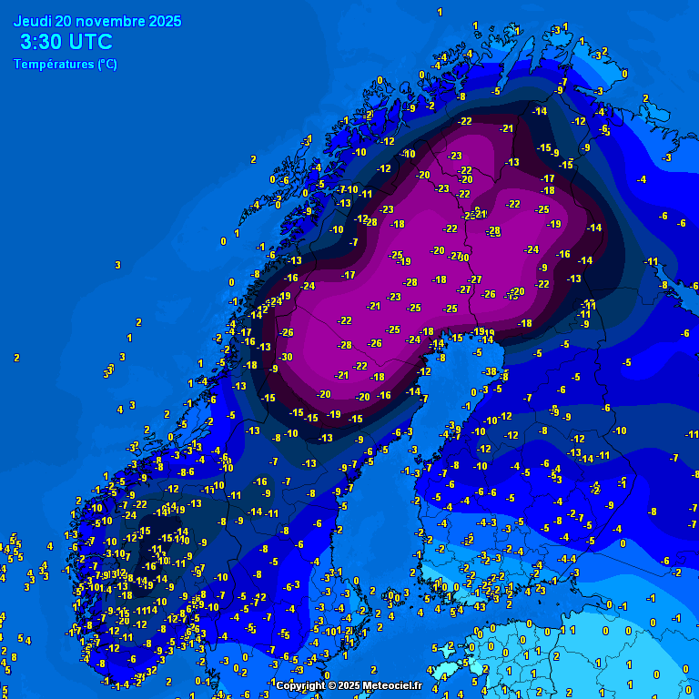
De eerste 30 graden van dit winterseizoen. In Gielas (Noorwegen) daalde het kwik tot 30.5 graden onder nul.
v
Zowel in Zweden, als in Finland is op een aantal plekken de temperatuur weer tot onder de -30 gezakt. Een fikse koudegolf momenteel in Lapland, die tot zeker halverwege volgende week lijkt aan te houden.
.png)
v

Willen wij ook! Kan best een pak vallen zo te zien, denk dat hinder nog zacht uitgedrukt is.quote:Op zaterdag 22 november 2025 17:53 schreef 12Beaufort het volgende:
Code oranje ivm sneeuw voor Parijs.
Vooral het verkeer kan hier veel hinder van ondervinden.
[ x ]
Hier nog een winterverwachting. Deze verwachting is positief voor de komende winter.
https://www.ronsweer.nl/definitieve-winterverwachting-2025-2026
https://www.ronsweer.nl/definitieve-winterverwachting-2025-2026
v
quote:Polar vortex collapse begins, colder winter expected in U.S., Canada, and Europe
A sudden stratospheric warming event has begun, deforming the Polar Vortex and setting the stage for a colder start to winter across the United States, Canada, and Europe.
Timeline of events:
November 21: SSW event detected and begins
November 25–28 (Thanksgiving): Peak disruption of the Polar Vortex in the stratosphere
December 1–7: First major surface impacts (cold air) expected in the US/Canada
Late December: Potential pattern shift bringing cold/snow to Europe.
A sudden stratospheric warming (SSW) event has begun and is weakening the Polar Vortex. This is expected to bring colder winter conditions across the United States, Canada, and Europe.
The latest analysis by Andrej Flis from Severe Weather Europe (SWE) shows that the Polar Vortex has already begun to deform in the mid-stratosphere (around 30 km / 18.5 miles altitude).
This is due to a high-pressure area located over the Arctic Ocean pushing it out of place. This high-pressure area–essentially an “anti-vortex”–is the direct result of the SSW event
A strong Polar Vortex locks cold air into the polar regions, creating milder winters. But when the Polar Vortex is disrupted or collapses, the cold air can escape, unleashing much colder winter conditions across the mid-latitudes (the U.S., Canada, and Europe).
Peak disruption of the vortex is forecast to occur around Thanksgiving in the stratosphere. However, the effects typically take around 2-3 weeks to propagate downward, meaning weather impacts should become visible across the mid-latitudes by early December.
This is one of the earliest collapse events on record. Only three similar early-season events have occurred in the last 70 years (1958, 1968, and 2000).
Currently, the core of the Polar Vortex is being displaced over eastern Canada and the Northeastern United States. As the vortex collapses, cold Arctic air will begin to spill downward. This positioning creates a "pump" that drives a sustained northerly flow, pulling deep polar air down from the Arctic.
A significant polar outbreak is forecast across the northern, central, and northeastern U.S. Forecasts suggest this pattern will remain fairly stable and increase the probability of a white Christmas across the country. Snowfall from the event is expected to extend far into the southwestern U.S., potentially reaching northwestern Texas.
Because the vortex core is positioned over North America, Europe will likely see a mild, warmer start to the month with westerly and southerly airflows.
Later in the pattern, a high-pressure system may form in the north while low pressure develops to the south, creating an easterly flow. This would open the gates for freezing air to move into Northern and Central Europe-a phenomenon often called "The Beast from the East"-bringing the potential for heavy snow across the region in winter.
Helaas is deze meer voor noord Amerika. Maar er gaan berichten rond dat er een tweede volgt die wel positief uitpakt voor Europa.quote:
 Op
Op Hopen we dan maar.
v
Een flink deel van de Siberische Republiek Jakoetië heeft een ijzige november achter de rug. In de doorgaans, tijdens het winterhalfjaar, koudste nederzetting van het Noordelijk Halfrond Oymyakon bedroeg het novembergemiddelde –36,0 tegen normaal –34,4°. Nog ijziger verliep november bij de ‘concurrentie’ ofwel in de nederzetting Verchojansk. Met een gemiddelde temperatuur van –39,2° was november maar liefst 5,5° te koud. De normale temperatuur is daar dus –33,7°. Verchojansk beleefde de koudste november in 1958. Toen werd het gemiddeld –44,4°.
https://x.com/janvissersweer/status/1995470206810910870?s=20
https://x.com/janvissersweer/status/1995470206810910870?s=20
v
Rond de kerstdagen laten de weermodellen de opbouw zien van hogedruk boven Scandinavie. Hierdoor ontstaat een meer oostelijke stroming waarmee koudere lucht het westen van Europa weet te vinden. Het is nog ver weg voor zekerheid en uiteraard moet alles goed liggen. Maar de trend is er zeker.

v
CFS laat tot halverwege januari een te koude maand zien voor een groot deel van Europa. Het is lastig om de lange termijn te voorspellen, omdat de onzekerheid groot is. Vooral voor west Europa kan het vriezen of dooien. De kans op kou is in ieder geval groter dan voorgaande jaren.

v

 Op
Op
De barre kou zit in Scandinavië. Het kwik daalt hier op uitgebreide schaal tot onder de -30. In het plaatsje 'Karasjok' (Noorwegen) daalde de temperatuur zelfs tot onder de -41.
.png)
v


quote:Bijzonder koud begin van het jaar in het hoge noorden van Europa. Het Noorse Karasjok noteerde 4 dagen achtereen -40º en lager; in het Finse Soankylä was de eerste decade (1-10 januari) maar liefst 16,5 graad te koud. Alleen in 1918 en in 1987 is dezelfde periode nog kouder verlopen.
https://x.com/i/status/2010630106398482623
v

Verkeerde topic
"Ik dit niet meer, Ik dit nooit meer
Ik niet meer kan, Niet meer ik
Dit niet meer, Ik niet meer" - Strani
Ik niet meer kan, Niet meer ik
Dit niet meer, Ik niet meer" - Strani
.png)
quote:Volle bak winter in Oost-Europa. In Belarus (Wit-Rusland) lokaal beneden -25 graden.
Oost-Europa is volop aan het winteren. In onder meer Oekraïne, Wit-Rusland (Belarus), Rusland en Litouwen vriest het op veel plaatsen meer dan 20 graden. Bovendien ligt er vrijwel overal een dik sneeuwtapijt: niet in de laatste plaats in de Russische hoofdstad Moskou. In delen van de stad lag deze week maar liefst 65 centimeter sneeuw hetgeen tot ernstige overlast leidde. Feitelijk ging het om de zwaarste sneeuwval sinds 1970.
In de hoofdstad van Belarus, Minsk, wees de thermometer tijdens de afgelopen nacht –23,0° aan, in Klicev werd –27,8° gemeten. De sneeuwhoogte bedraagt daar 38 centimeter.
https://janvissersweer.nl/vandaag-actueel-weer/
v

Talrijke ongelukken en scholen dicht in Duitsland door gladheid
IJzel in Duitsland heeft tot honderden ongelukken geleid. Bij twee ongevallen op de autosnelweg A44 in de buurt van Paderborn zijn drie mensen om het leven gekomen. In de aan Nederland grenzende deelstaat Nedersaksen zijn veel scholen gesloten omdat de wegen zo glad zijn. Op de A44, die van Aken naar Kassel loopt, zijn volgens de politie zeventien botsingen geweest.
https://www.rd.nl/artikel(...)tsland-door-gladheid
v
In de ‘Vall de Núria’, een bergdal aan de zuidflank van de Catalaanse Pyreneeën in de ‘comarca’ (streek) Ripollès, is voor wat betreft de 21ste eeuw een sneeuwrecord geregistreerd. Op het weerstation Núria, gelegen op 1971 meter hoogte, bedroeg de sneeuwhoogte maandagochtend 144 centimeter. Uit een analyse van ‘Seguim la Méteo’ blijkt dat er voor het laatst in 1996 een vergelijkbare hoeveelheid sneeuw werd aangetroffen.
https://janvissersweer.nl/vandaag-actueel-weer/
https://janvissersweer.nl/vandaag-actueel-weer/
v
|
|