WKN Weer, Klimaat en Natuurrampen
Lees alles over het onstuimige weer op onze planeet, volg orkanen en tornado's, zie hoe vulkanen uitbarsten en hoe Moeder Aarde beeft bij een aardbeving. Alles over de verwoestende kracht van onze planeet en tal van andere natuurverschijnselen.


Today has seen the deepest October snowfall in Reykjavík, ever. The weather hit worse, and faster, than forecasts had suggested. Many drivers have been caught out and found themselves stranded or abandoning their vehicles, many of which were not properly equipped for winter conditions.
Around 4 am on Tuesday, snow clearing work began on main roads and the pathway network. This work has continued throughout the day as snow has kept falling heavily.
Drivers of poorly equipped vehicles - especially those on summer tyres - were again urged not to drive in the difficult winter conditions.
There are yellow weather alerts in place across the capital area, the South, and Faxaflói. They generally warn of snowfall with poor visibility, and transport disturbances. People are advised to show caution and monitor weather forecasts.
Orange weather alerts which were in place, have just been lifted.
Snowfall in the capital area and on the Reykjanes Peninsula is likely coming to an end for now. Precipitation has decreased significantly, and no further snowfall is expected there this evening, said Óli Þór Árnason, meteorologist at the Icelandic Met Office.
Capital area police and Civil Defence recommended that everyone in the affected areas return home by 3pm Tuesday; advice which many seem to have heeded.
Reykjavík City enhanced many of its essential services, while closing others for the day.
The snowfall has affected flight operations today, but most flights operated by foreign airlines at Keflavík Airport remain on schedule, according to ISAVIA’s website. Icelandair cancelled all flights scheduled for after midday, and there were delays this morning.
Conditions are expected to ease towards Wednesday evening. Our live coverage will resume tomorrow as the severe weather makes its way over and out of the country.
https://www.ruv.is/englis(...)ngs-live-blog-457337
[ Bericht 5% gewijzigd door 12Beaufort op 28-10-2025 19:41:10 ]
v
Er wordt vanavond een 'Blizzard' verwacht in het noorden van IJsland.
https://www.ruv.is/englis(...)north-tonight-457588quote:A new area of low pressure is expected to make itself felt in North Iceland late this evening and overnight.
It is arriving from Jan Mayen, a little further north, and will bring blizzard conditions. This applies in particular to Öxnadalsheiði, Þverárfjall, Siglufjörður and Ólafsfjörður, and from Ljósavatnsskarð via Húsavík and east towards Vopnafjörður.
Blowing snow is also expected on Möðrudalsöræfi.
According to the precipitation forecast on the website of Veðurstofa Íslands (Icelandic Met Office), the heaviest snowfall will be from Húnaflói to Vopnafjörður this evening and into the night, but by morning precipitation will also increase in the Westfjords.
The Met Office reports the following on its website:quote:Wind will increase to northwesterly 10-18 m/s with showers of snow and blowing snow in the northeast of the country late this evening. Poor visibility and difficult driving conditions can be expected until around midday tomorrow, particularly on mountain roads.
v
‘Volle bak winter’ op IJsland! De hoofdstad Reykjavik werd de afgelopen dagen bedolven onder een voor oktober historisch dik pak sneeuw.
IJsland fungeert dezer dagen als ‘uithangbord’ van Koning Winter. Een ogenschijnlijk onbeduidende storing dumpte de afgelopen twee dagen onwijs veel sneeuw in en rond de hoofdstad Reykjavik en diverse locaties registreerden minima beneden –15 graden.
Afgelopen dinsdagochtend bedroeg de sneeuwhoogte in Reykjavik maar liefst 27 centimeter en gisterochtend zowaar 40 centimeter. Niet eerder werd Reykjavik in oktober bedolven onder zoveel sneeuw. Het record stond op slechts 15 centimeter en dateerde van 22 oktober 1921. De records van de wintermaanden januari en februari zijn 55 centimeter op 18 januari 1937 en 51 centimeter op 26 februari 2017.
Wat de kou betreft: gisteren rapporteerde Langamýri sólgeislun -18,2°, vanochtend registreerde Sandskeið -19,8° en in de hogere delen van IJsland kwam Setur uit op –20,2°.
https://janvissersweer.nl/vandaag-actueel-weer/#google_vignette
v
Het noordoostelijk deel van Siberië is zo’n beetje het enige deel van het Noordelijk Halfrond waar Koning Winter zich de afgelopen weken nadrukkelijk deed gelden. Recentelijk werden op een aantal locaties zelfs ongewoon lage temperaturen gemeten. Zo registreerde op 30 oktober het aan het noordwestelijk deel van de Beringzee gelegen Anadyr –27,4°. Dat is voor oktober de op één na laagste temperatuur sinds 1898. Toen werd –28,2° gemeten.
Tijdens de afgelopen 24 uur vroor het voor het eerst dit seizoen 40 graden op een Siberisch weerstation. In Konstantinovskaya, gelegen op de 68ste breedtegraad, werd het –40,0°.
https://janvissersweer.nl/vandaag-actueel-weer/
Tijdens de afgelopen 24 uur vroor het voor het eerst dit seizoen 40 graden op een Siberisch weerstation. In Konstantinovskaya, gelegen op de 68ste breedtegraad, werd het –40,0°.
https://janvissersweer.nl/vandaag-actueel-weer/
v


quote:Onder regie van een koud hoogtelaag boven de Barentsz Zee en Noord-Rusland ‘rommelt’ de winter het noorden van Scandinavië binnen. In de Noorse provincies Troms en Finnmark heeft het de afgelopen 24 uur regionaal flink gesneeuwd. Tromsø meldde vanochtend een sneeuwhoogte van 12 en Suolovuopmi 25 centimeter.
In Noord-Zweden (Norrland) vroor het vanochtend plaatselijk meer dan 15 graden Zo meldde Gielas –16,7 en Buresjön -17,5°.
In de loop van de week veroorzaakt een sterk uitdiepende depressie (donderdagmiddag 975 hPa boven het Russische schiereiland Kola) regionaal intensieve sneeuwval.
https://janvissersweer.nl/weerpraatje-actueel
v


Een wintervoorspelling. Ik heb de belangrijkste stukken er even uitgehaald. Hier staat het volledige verhaal.
quote:Met Office (UK): licht positieve NAO
De Noord-Atlantische Oscillatie (NAO) beschrijft het drukverschil tussen de Azoren en IJsland, wat het winterweer in Europa en Noord-Amerika beïnvloedt. In de positieve fase is het milder en stormachtiger, in de negatieve fase kouder en droger. De NAO beïnvloedt de staalstroom en stormfrequentie.
Licht positieve NAO in de vroege maanden van de winter, gevolgd door een negatieve NAO eind januari en februari. Een positieve NAO betekent mildere omstandigheden in december, terwijl een negatieve NAO in januari en februari zou kunnen leiden tot koude luchtstromen vanuit het noorden, wat de kansen op sneeuwval in Europa vergroot, vooral in de Alpen en Centraal-Europa.
ECMWF voorspelt voor de winter van 2025/2026 op een verhoogde kans op sneeuw in de Noord-Alpen en het Zwitsers hooggebergte (Walliser- en Berner Alpen) als gevolg van koude luchtstromen. Dit model benadrukt dat, ondanks de neutrale ENSO, de koudere lucht in combinatie met het Nordstau-effect de kans op sneeuw vergroot. Noordwest-Europa (Oostenrijk, Zwitserland) heeft de beste kansen op een sneeuwrijke winter.
Stratosferische Warme Verstoringen (SSW)
Er is momenteel een opbouw van stratosferische signalen die wijzen op de mogelijkheid van een stratosferische warme verstoring (SSW). Dit kan de polar vortex verstoren, wat de kans op koude luchtstromen uit het noorden vergroot. Een SSW kan zorgen voor extreme kou in Europa, vooral in de wintermaanden, wanneer de koude lucht lange periodes van kou kan veroorzaken. Dit zou de kans op een strenge winter verder versterken, vooral in de tweede helft van de winter.
v
Winterinval in Noord-Europa: een krachtige depressie boven het noorden van Finland stuurt de komende dagen koude en vochtige pool lucht ver naar het zuiden. Het gevolg is hevige sneeuwval van Noord-Scandinavië tot Zuid-Noorwegen.
Het is niet alleen in het noorden dat er veel sneeuw valt. In Noorwegen sneeuwt het ook relatief ver naar het zuiden, onder andere in het gebied tussen Bergen en Trondheim. Vooral in de bergachtige regio's kan er daar 50 centimeter tot 1 meter verse sneeuw vallen.
Bovendien dalen de temperaturen sterk. Op vrijdag liggen de maximumtemperaturen meestal rond 0 graden of zelfs nog lager.
https://www.weerenradar.n(...)f7-9ef3-184ed9916d3c
v
Polar low voor Noorwegen.
quote:Polar low
A polar low is currently located between C4 and deep D4. The low is expected to move southward during the day. In the western and northern parts of the low, northerly winds reaching strong gale force 9 and occasionally storm force 10 is expected. The low is expected to make landfall along the coast of the northern parts of Moere og Romsdal and the southern parts of Troendelag during early Friday morning. In association with the system, heavy snow showers, locally strong gusts of wind and blowing snow are expected. There will be large local variations in intensity and snow amounts, in the low lands precipitation locally as sleet. The low is expected to weaken Friday morning.
https://www.yr.no/en/weather-warnings
v

quote:Op donderdag 13 november 2025 10:56 schreef 12Beaufort het volgende:
Winterinval in Noord-Europa: een krachtige depressie boven het noorden van Finland stuurt de komende dagen koude en vochtige pool lucht ver naar het zuiden. Het gevolg is hevige sneeuwval van Noord-Scandinavië tot Zuid-Noorwegen.
Het is niet alleen in het noorden dat er veel sneeuw valt. In Noorwegen sneeuwt het ook relatief ver naar het zuiden, onder andere in het gebied tussen Bergen en Trondheim. Vooral in de bergachtige regio's kan er daar 50 centimeter tot 1 meter verse sneeuw vallen.
Bovendien dalen de temperaturen sterk. Op vrijdag liggen de maximumtemperaturen meestal rond 0 graden of zelfs nog lager.
https://www.weerenradar.n(...)f7-9ef3-184ed9916d3c

Dat extra koude stuk in Finland is ongeveer waar mijn vriendin nu zit, stuurde net een foto door vanuit de auto...ik kan bevestigen dat het inderdaad aan de frisse kant is.

Gaan we richting de min 30 vannacht? Voor het gevoel is het plaatselijk al -32 in Finland. Onder een dik sneeuwdek is in een groot deel van Lapland de temperatuur vandaag niet boven de -20 uitgekomen 


v
A large part of Scandinavia is already covered in snow. And in northern Norway there is really a lot of it. Tromsø is reporting 72 cm, which is the highest November value since 2013 and one of the most significant early-winter snow depths here in the last 100 years.
https://x.com/Ventuskycom(...)awuL9i6CAXgwHCQ&s=19

https://x.com/Ventuskycom(...)awuL9i6CAXgwHCQ&s=19
v
quote:In het noorden van Scandinavië ging het tijdens de afgelopen nacht van dik hout. Nabij de Finse grens meldde het Zweedse Muodoslompolo –29,4°, in Finland registreerde Sodankylä Vuotso –29,5°. Tijdens de koudegolf van november 1983 werd daar op de 26ste –36,0° gemeten.
https://x.com/janvissersw(...)WG9b9HD2Aj0uxHg&s=19
v
Spanje maakt zich deze week op voor een plotselinge winterinval. Een koude luchtmassa uit het noorden trekt het land binnen en zorgt voor lage temperaturen, sneeuwval en nachtelijke vorst in grote delen van het land. De winter lijkt dit jaar dus eerder te beginnen dan normaal.
Volgens de Spaanse weerdienst AEMET dalen de temperaturen vanaf dinsdag flink. Vooral in het noorden, het binnenland en de berggebieden wordt het koud, met sneeuw die tot op lagere hoogtes kan vallen. De sneeuwgrens zakt vanaf woensdag tot rond de 800 meter en in sommige regio’s zelfs tot 500 meter.
In de noordelijke regio’s, zoals Asturië, Cantabrië en Castilië en León, worden de eerste echte sneeuwval en gladde wegen verwacht. Ook in Madrid en Guadalajara kan het in de nachten gaan vriezen. Op de hoogvlaktes worden minima onder nul voorspeld, wat kan leiden tot ijsvorming op de wegen.
In het zuiden en op de Balearen zal de koude lucht gepaard gaan met harde wind en buien, waardoor de gevoelstemperatuur nog lager ligt. De Pyreneeën in o.a. Aragón en Catalonië en de Cantabrische bergen krijgen de meeste sneeuw, mogelijk ook buiten de gebruikelijke skigebieden.
lees hier verder
v


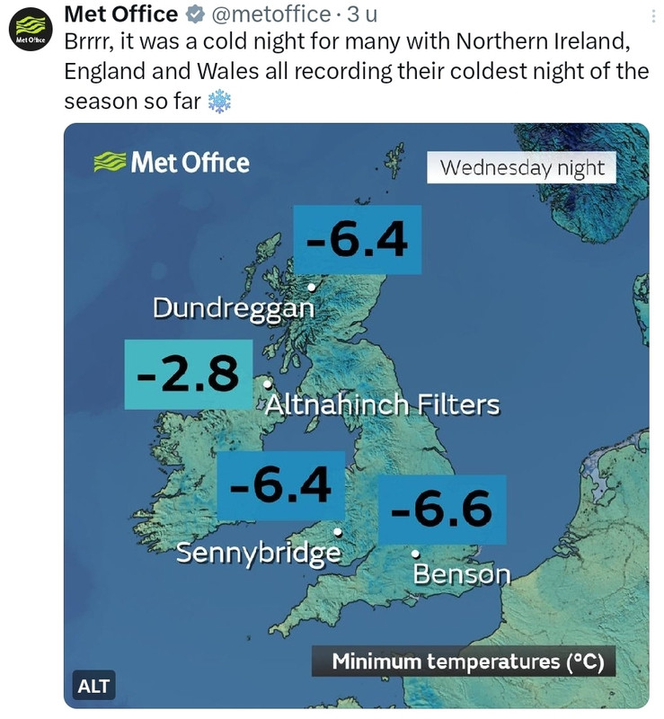
En ook in Schotland is het wit geworden.
De temperatuur boven de Schotse Hooglanden is nog steeds onder het vriespunt. Vanmorgen was het hier 8 graden onder nul.
De temperatuur boven de Schotse Hooglanden is nog steeds onder het vriespunt. Vanmorgen was het hier 8 graden onder nul.


v

De eerste 30 graden van dit winterseizoen. In Gielas (Noorwegen) daalde het kwik tot 30.5 graden onder nul.
v
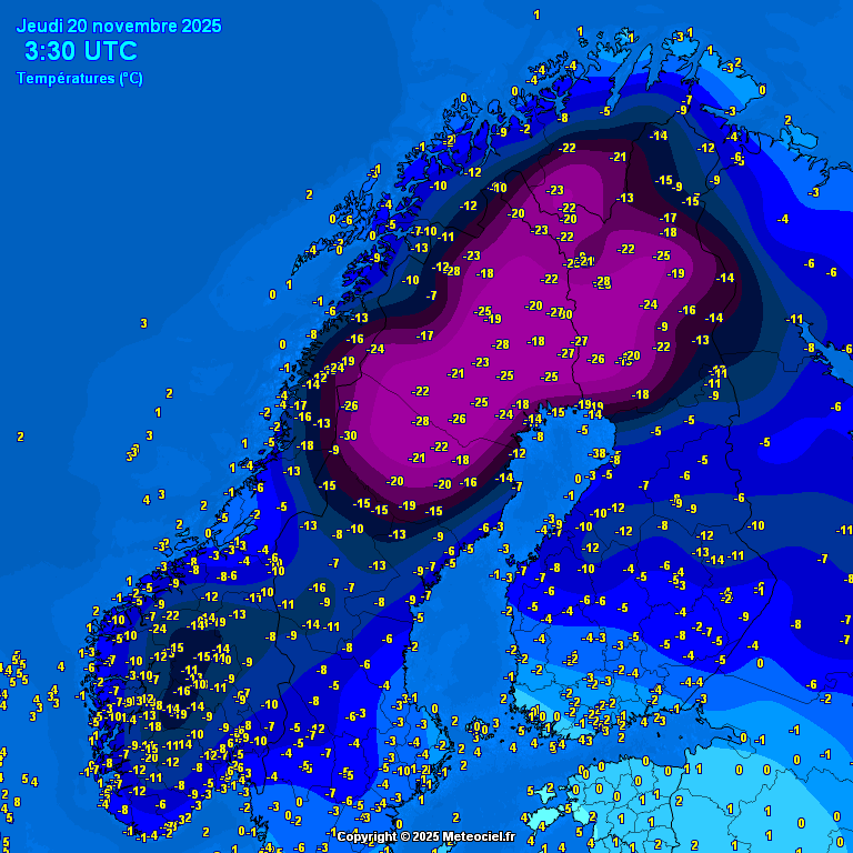
Zowel in Zweden, als in Finland is op een aantal plekken de temperatuur weer tot onder de -30 gezakt. Een fikse koudegolf momenteel in Lapland, die tot zeker halverwege volgende week lijkt aan te houden.
.png)
v

Willen wij ook! Kan best een pak vallen zo te zien, denk dat hinder nog zacht uitgedrukt is.quote:
Code oranje ivm sneeuw voor Parijs.
Vooral het verkeer kan hier veel hinder van ondervinden.
[ x ]
Hier nog een winterverwachting. Deze verwachting is positief voor de komende winter.
https://www.ronsweer.nl/definitieve-winterverwachting-2025-2026
https://www.ronsweer.nl/definitieve-winterverwachting-2025-2026
v
quote:Polar vortex collapse begins, colder winter expected in U.S., Canada, and Europe
A sudden stratospheric warming event has begun, deforming the Polar Vortex and setting the stage for a colder start to winter across the United States, Canada, and Europe.
Timeline of events:
November 21: SSW event detected and begins
November 25–28 (Thanksgiving): Peak disruption of the Polar Vortex in the stratosphere
December 1–7: First major surface impacts (cold air) expected in the US/Canada
Late December: Potential pattern shift bringing cold/snow to Europe.
A sudden stratospheric warming (SSW) event has begun and is weakening the Polar Vortex. This is expected to bring colder winter conditions across the United States, Canada, and Europe.
The latest analysis by Andrej Flis from Severe Weather Europe (SWE) shows that the Polar Vortex has already begun to deform in the mid-stratosphere (around 30 km / 18.5 miles altitude).
This is due to a high-pressure area located over the Arctic Ocean pushing it out of place. This high-pressure area–essentially an “anti-vortex”–is the direct result of the SSW event
A strong Polar Vortex locks cold air into the polar regions, creating milder winters. But when the Polar Vortex is disrupted or collapses, the cold air can escape, unleashing much colder winter conditions across the mid-latitudes (the U.S., Canada, and Europe).
Peak disruption of the vortex is forecast to occur around Thanksgiving in the stratosphere. However, the effects typically take around 2-3 weeks to propagate downward, meaning weather impacts should become visible across the mid-latitudes by early December.
This is one of the earliest collapse events on record. Only three similar early-season events have occurred in the last 70 years (1958, 1968, and 2000).
Currently, the core of the Polar Vortex is being displaced over eastern Canada and the Northeastern United States. As the vortex collapses, cold Arctic air will begin to spill downward. This positioning creates a "pump" that drives a sustained northerly flow, pulling deep polar air down from the Arctic.
A significant polar outbreak is forecast across the northern, central, and northeastern U.S. Forecasts suggest this pattern will remain fairly stable and increase the probability of a white Christmas across the country. Snowfall from the event is expected to extend far into the southwestern U.S., potentially reaching northwestern Texas.
Because the vortex core is positioned over North America, Europe will likely see a mild, warmer start to the month with westerly and southerly airflows.
Later in the pattern, a high-pressure system may form in the north while low pressure develops to the south, creating an easterly flow. This would open the gates for freezing air to move into Northern and Central Europe-a phenomenon often called "The Beast from the East"-bringing the potential for heavy snow across the region in winter.
Helaas is deze meer voor noord Amerika. Maar er gaan berichten rond dat er een tweede volgt die wel positief uitpakt voor Europa.quote:
 Op
Op Hopen we dan maar.
v
Een flink deel van de Siberische Republiek Jakoetië heeft een ijzige november achter de rug. In de doorgaans, tijdens het winterhalfjaar, koudste nederzetting van het Noordelijk Halfrond Oymyakon bedroeg het novembergemiddelde –36,0 tegen normaal –34,4°. Nog ijziger verliep november bij de ‘concurrentie’ ofwel in de nederzetting Verchojansk. Met een gemiddelde temperatuur van –39,2° was november maar liefst 5,5° te koud. De normale temperatuur is daar dus –33,7°. Verchojansk beleefde de koudste november in 1958. Toen werd het gemiddeld –44,4°.
https://x.com/janvissersweer/status/1995470206810910870?s=20
https://x.com/janvissersweer/status/1995470206810910870?s=20
v
Rond de kerstdagen laten de weermodellen de opbouw zien van hogedruk boven Scandinavie. Hierdoor ontstaat een meer oostelijke stroming waarmee koudere lucht het westen van Europa weet te vinden. Het is nog ver weg voor zekerheid en uiteraard moet alles goed liggen. Maar de trend is er zeker.

v
CFS laat tot halverwege januari een te koude maand zien voor een groot deel van Europa. Het is lastig om de lange termijn te voorspellen, omdat de onzekerheid groot is. Vooral voor west Europa kan het vriezen of dooien. De kans op kou is in ieder geval groter dan voorgaande jaren.

v

 Op
Op
De barre kou zit in Scandinavië. Het kwik daalt hier op uitgebreide schaal tot onder de -30. In het plaatsje 'Karasjok' (Noorwegen) daalde de temperatuur zelfs tot onder de -41.
.png)
v


quote:Bijzonder koud begin van het jaar in het hoge noorden van Europa. Het Noorse Karasjok noteerde 4 dagen achtereen -40º en lager; in het Finse Soankylä was de eerste decade (1-10 januari) maar liefst 16,5 graad te koud. Alleen in 1918 en in 1987 is dezelfde periode nog kouder verlopen.
https://x.com/i/status/2010630106398482623
v

Verkeerde topic
"Ik dit niet meer, Ik dit nooit meer
Ik niet meer kan, Niet meer ik
Dit niet meer, Ik niet meer" - Strani
Ik niet meer kan, Niet meer ik
Dit niet meer, Ik niet meer" - Strani
.png)
quote:Volle bak winter in Oost-Europa. In Belarus (Wit-Rusland) lokaal beneden -25 graden.
Oost-Europa is volop aan het winteren. In onder meer Oekraïne, Wit-Rusland (Belarus), Rusland en Litouwen vriest het op veel plaatsen meer dan 20 graden. Bovendien ligt er vrijwel overal een dik sneeuwtapijt: niet in de laatste plaats in de Russische hoofdstad Moskou. In delen van de stad lag deze week maar liefst 65 centimeter sneeuw hetgeen tot ernstige overlast leidde. Feitelijk ging het om de zwaarste sneeuwval sinds 1970.
In de hoofdstad van Belarus, Minsk, wees de thermometer tijdens de afgelopen nacht –23,0° aan, in Klicev werd –27,8° gemeten. De sneeuwhoogte bedraagt daar 38 centimeter.
https://janvissersweer.nl/vandaag-actueel-weer/
v
Talrijke ongelukken en scholen dicht in Duitsland door gladheid
IJzel in Duitsland heeft tot honderden ongelukken geleid. Bij twee ongevallen op de autosnelweg A44 in de buurt van Paderborn zijn drie mensen om het leven gekomen. In de aan Nederland grenzende deelstaat Nedersaksen zijn veel scholen gesloten omdat de wegen zo glad zijn. Op de A44, die van Aken naar Kassel loopt, zijn volgens de politie zeventien botsingen geweest.
https://www.rd.nl/artikel(...)tsland-door-gladheid
v
In de ‘Vall de Núria’, een bergdal aan de zuidflank van de Catalaanse Pyreneeën in de ‘comarca’ (streek) Ripollès, is voor wat betreft de 21ste eeuw een sneeuwrecord geregistreerd. Op het weerstation Núria, gelegen op 1971 meter hoogte, bedroeg de sneeuwhoogte maandagochtend 144 centimeter. Uit een analyse van ‘Seguim la Méteo’ blijkt dat er voor het laatst in 1996 een vergelijkbare hoeveelheid sneeuw werd aangetroffen.
https://janvissersweer.nl/vandaag-actueel-weer/
https://janvissersweer.nl/vandaag-actueel-weer/
v
|
|