WKN Weer, Klimaat en Natuurrampen
Lees alles over het onstuimige weer op onze planeet, volg orkanen en tornado's, zie hoe vulkanen uitbarsten en hoe Moeder Aarde beeft bij een aardbeving. Alles over de verwoestende kracht van onze planeet en tal van andere natuurverschijnselen.


Overal in de wereld kom je vulkanen tegen. Onder water, in bergruggen of onder gletsjers. Ook zijn er vulkanen waar niemand het bestaan nog van weet of waar we pas sinds kort achter kwamen dat het daadwerkelijk een vulkaan is. Vulkanen vind je ook op andere planeten in ons zonnestelsel!
In dit topic kun je alle informatie kwijt over vulkanen, je kunt vragen stellen over vulkanen of uitbarstingen maar vooral kun je hier op de hoogte blijven van de recentelijke ontwikkelingen van vulkanen overal ter wereld.
Voel je vrij om mee te posten. Zie je ergens een interessant artikel, heb je een nieuwsbericht, post het hier en doe gezellig mee
Wat is een vulkaan
Bekijk deze YouTube-video
Hoe ontstaan vulkanen?
Bekijk deze YouTube-video
Hoe werkt het dan?
Bekijk deze YouTube-video
Waar bevinden zich de vulkanen dan?
De meeste vulkanen bevinden zich rondom de tektonische platen van onze planeet. Daar waar de aardplaten langs of onder elkaar schuiven vinden aardbevingen plaats of is er sprake vulkanische activiteit.
Een uitzondering op deze regel zijn de zogenaamde 'hot-spots'. Dit zijn plaatsen op aarde waarbij magma uit de aardmantel door de aardkorst naar boven komt. Voorbeelden hiervan zijn de eilanden van Hawaii en de Canarische Eilanden. In honderden, zo niet duizenden, jaren tijd krijg je meerdere erupties die naar verloop van tijd weer stoppen. In de honderden jaren er na verplaatsen de aardschollen zich en als er honderd(en) jaren later een nieuwe eruptie plaatsvindt kan er een nieuw eiland ontstaan. Maar er zijn meer vulkaantypes.
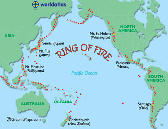
De meeste vulkanen op aarde liggen rond de zogenaamde 'Ring of Fire'. Maar liefst 75% van alle vulkanen op aarde, zo'n 450 stuks, ligt in de buurt van (of op) de Ring van Fire.
De zogenaamde Ring van Vuur is een bijna ringvormige keten aan vulkanisch actieve gebieden. Deze Ring "verbindt" zo de Zuidelijke Pacifische Oceaan bij Nieuw_Zeeland met de klok mee via de Filipijnen en Japan naar het Russische Kamtsjatka en via Alaska naar de kust van Californië helemaal tot aan het zuiden van Chili.
Ring van Vuur
Soorten vulkanen
Er zijn 6 verschillende soorten vulkanen.
• De spleetvulkaan
Een lange scheur in de aardkorst waardoor magma naar buiten komt. Deze ontstaat als twee tektonische platen uit elkaar drijven. Je vindt deze vooral bij oceaanruggen.
• De schildvulkaan
Dit is een brede, ondiepe vulkaankegel, die ontstaat doordat het lava dat eruit stroomt, dun en heet is en heel langzaam afkoelt.
• De koepelvulkaan
Deze kent een steile, bolle helling die gevormd is door dikke snel afkoelende lava.
• De slakkenkegel
Een vulkaan die naast lava ook veel as uitspuugt. De berg die door deze vulkaan gevormd wordt, is dan ook opgebouwd uit lagen as en lava die elkaar afwisselen.
• De samengestelde vulkaan
Deze is net zo opgebouwd als de slakkenkegel maar heeft naast de hoofdkrater nog meerdere kleinere kraters op haar flanken.
• De calderavulkaan
Dit is een oudere vulkaan met aan de bovenkant een grote brede krater. In deze krater hebben zich weer kleinere nieuwe kraters gevormd.
• Hotspots
Doordat een zeer hete brandhaard (hot-spot) in de mantel, door de aardkorst heen brandt.
Overige vormen
Andere vormen van vulkanisme zijn de geisers en de hete bronnen. Die vind je vaak in de buurt van vulkanen waar de aardkorst dunner is en de warmte van het magma verder doordringt in de aardkorst. Een geiser is een holte in de aardkorst of een waterhoudende grondlaag, die door het onderliggende magma wordt verwarmd tot het kookpunt. Het water kan dan tot 500 meter in de lucht spuiten. Een hete bron werkt op dezelfde manier alleen wordt het water daar niet zo verhit, dat het onder druk van stoom eruit spuit.
Supervulkanen
Naast de 'reguliere' vulkanen hebben we op aarde ook 'supervulkanen'. Dat zijn vulkanen die in staat zijn om tot catastrofale uitbarstingen te komen die het leven op de hele planeet kunnen beïnvloeden. Zij kunnen bijvoorbeeld een nieuwe ijstijd in gang zetten. De laatste uitbarsting van een supervulkaan was die van Toba (Sumatra) zo'n 74.000 jaar geleden. De bekendste supervulkaan is vermoedelijk Yellowstone Park in de Verenigde Staten. De dichtstbijzijnde supervulkaan is de Campi Flegrei bij Napels.
Heeft Nederland een vulkaan?
Jazeker! De naam ervan is Zuidwalvulkaan, en ligt 17 km ten westen van Harlingen
maar ... die is letterlijk allang dood en begraven. Deze ligt namelijk vele honderden meters onder de bodem van de huidige Waddenzee. De vulkaan was actief in het Laat-Jura, zo'n 152 miljoen jaar geleden.
Maar slapen vulkanen echt en zijn ze echt dood? Daar verschillen wetenschappers van mening over. Langere tijd werd ook gedacht dat bijvoorbeeld de supervulkaan in de Eifel (Duitsland) dood en begraven was maar recente studies hebben uitgewezen dat deze zeker niet dood is. Sterker nog: Onlangs werd bekend dat de magmakamer van de Laacher See vulkaan zich weer langzaam aan het vullen is.
Actueel Actieve vulkanen
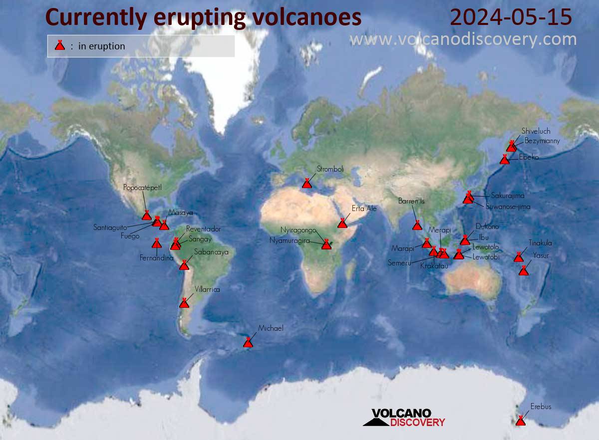
Met dank aan Volcano Discovery
Handige en/of belangrijke links
• Volcano webcams all over the world
• Volcano Discovery
• Live Science - Volcanoes
• Vulkaan - Startpagina.nl
Foto's
• 2018: Volcano Activity in Pictures
• 2019: Volcano Activity in Pictures
• 2020: Volcano Activity in Pictures
• 2021: Volcano Activity in Pictures
• 2022: Volcano Activity in Pictures
• 2023: Volcano Activity in Pictures
• [url=https://www.theatlantic.com/photo/2024/12/2024-year-volcanic-activity/681153/[2024: Volcano Activity in Pictures[/url]
Actuele vulkaantopics in WKN
WKN / [ACTUEEL] Vulkanen IJsland #27: Uitbarsting Reykjanes
WKN / [ACTUEEL] Seismische crisis op Grieks eiland Santorini
WKN / Campi Flegrei Napels: Supervulkaan kan leven Europa in bedreigen
WKN / De Riftvallei: Splitsing Oost-Afrika gaat mogelijk sneller dan gedacht
WKN / Vulkaan Kilauea op Hawaii
WKN / Nieuwe activiteit bij Etna op Sicilië
Archief en Verzameltopics
• Reeks: Vulkanen op Fok!
• Krakatoa
• Etna
• Supervulkaan Yellowstone
• Uitbarsting Merapi 2010
• Mount St.Helens
• Uitbarsting El Hierro Canarische Eilanden
• Vulkaanuitbarsting Chili
• Tungaruhua Ecuador
• Vulkanen op IJsland
Interessante Twitter-accounts van Vulkanologen
• https://twitter.com/johnseach
• https://twitter.com/volcanologist
• https://twitter.com/janinekrippner
• https://twitter.com/kenhrubin

Laatste posts uit vorige topic
[ Bericht 6% gewijzigd door Frutsel op 03-04-2025 13:50:00 ]
Activiteit Kanlaonquote:Japan maakt zich klaar voor mogelijke uitbarsting van vulkaan Mount Fuji
De Japanse overheid maakt nieuwe richtlijnen bekend over hoe de bevolking zich moet voorbereiden op een mogelijke uitbarsting van Mount Fuji, de beroemde vulkaan bij Tokio. Hoewel er geen directe tekenen zijn dat de vulkaan op korte termijn zal uitbarsten, blijft deze actief. Experts benadrukken dat vooruitdenken en voorbereiding moeten om grote schade en chaos te voorkomen.
Mount Fuji, de meest iconische vulkaan van Japan, is al 318 jaar in rust. De laatste uitbarsting vond plaats in 1707 en had destijds een grote impact op het land. Experts waarschuwen voor de mogelijkheid van een nieuwe explosieve uitbarsting, vergelijkbaar met 300 jaar geleden. Dat kan uitgebreide schade veroorzaken, vooral in stedelijke gebieden, zoals Tokio.
Volgens Toshitsugu Fujii, professor aan de Universiteit van Tokio, heeft het Japanse rampenplan rekening gehouden met een mogelijk worstcasescenario. “Bij een grote uitbarsting verwachten we dat er tot 1,7 miljard kubieke meter vulkanische as vrijkomt, waarvan ongeveer 490 miljoen kubieke meter zich zal ophopen op wegen, gebouwen en andere infrastructuur”, zei hij tijdens een persconferentie op 21 maart.
Hij waarschuwt dat een dergelijke ophoping niet alleen logistieke problemen zou veroorzaken, maar ook een groot risico voor de veiligheid van mensen.
Richtlijnen
De richtlijnen van de Japanse autoriteiten benadrukken dat burgers tijdens een uitbarsting zoveel mogelijk thuis moeten blijven. Het advies is om een noodvoorraad van belangrijke goederen aan te leggen die minimaal twee weken meegaat.
Evacuatie kan echter noodzakelijk worden als meer dan 30 centimeter vulkanische as zich ophoopt. Dit kan leiden tot het instortingsgevaar van houten huizen met een lage draagkracht. “Een uitbarsting betekent niet alleen asregen, maar ook mogelijke verstoring van elektriciteit, waterleidingnetten en transport", vervolgt Fujii. De overheid is voorbereid is om op grote schaal hulp te bieden, mits inwoners tijdig de basisrichtlijnen volgen.
Gevolgen
Zelfs een kleine hoeveelheid vulkanische as kan grote verstoringen veroorzaken. Dit begint bij het transport: treinen zouden kunnen stoppen met rijden en wegen kunnen onbruikbaar worden wanneer de as zich ophoopt, vooral in combinatie met regen. Daarnaast kan de ophoping leiden tot stroomstoringen, wat het leven in stedelijke gebieden volledig ontregelt.
De lucht zou bedekt worden met zwarte vulkanische as, waardoor stedelijke gebieden zelfs overdag in het donker zouden zitten, volgens de regering.
De economische impact van een grote Mount Fuji-uitbarsting wordt geschat op maximaal 2,5 triljoen yen (ongeveer 15,4 miljard euro). Naast directe schade aan wegen en gebouwen, zouden distributiesystemen en logistiek ernstig verstoord worden, waardoor het verkrijgen van essentiële goederen moeilijk wordt.
[ Bericht 6% gewijzigd door Frutsel op 03-04-2025 13:50:00 ]

quote:Filipijnse vulkaan spuwt aswolk vier kilometer hoog de lucht in
Een vulkaan in het centrum van de Filipijnen is dinsdagochtend kort uitgebarsten. Dat heeft het Filipijnse vulkanologische instituut bekendgemaakt. Een aswolk van ongeveer vier kilometer hoog is daarbij vrijgekomen.
“Een explosieve uitbarsting” vond plaats op de top van de Kanlaon-vulkaan tussen 5.51 en 6.47 uur lokale tijd (23.51 uur maandag en 00.47 uur dinsdag Belgische tijd). De aswolk steeg ongeveer 4.000 meter hoog en beweegt richting het zuidwesten, aldus het instituut.
“We waren voorbereid op de uitbarsting. Families op vier tot zes kilometer (rond de vulkaan) waren al geëvacueerd tijdens de vorige uitbarsting afgelopen december”, zegt reddingswerker John De Asis.
Het derde alarmniveau op een schaal van vijf niveaus is van kracht sinds de uitbarsting in december. De vulkaan ligt op het eiland Negros.
quote:Red Alert issued following eruption at Poás volcano, Costa Rica
A Red Alert was issued for Poás Volcano National Park in Costa Rica on Wednesday, April 23, 2025, after a series of eruptions produced ash plumes reaching up to 4 500 m (15 000 feet) above the crater. Ashfall was reported in several surrounding areas, prompting Orange Alerts in Grecia and Sarchí, and Yellow Alerts in Alajuela, Poás, Naranjo, Río Cuarto, and Zarcero due to increased volcanic hazards.
A powerful eruption occurred at Poás Volcano at 14:14 local time on Monday, April 21, 2025, initially sending an ash column approximately 2 000 m (6 500 feet) above the crater.
Later observations by the Volcanological and Seismological Observatory of Costa Rica (OVSICORI) reported the ash plume reaching up to 4.5 km (15 000 feet) above the crater.
The eruption, which lasted approximately 10 minutes, was preceded by a 7-hour period of very low seismic activity. Following the initial explosion, Poás continued to emit ash and volcanic gases throughout the afternoon while seismicity gradually returned to pre-eruptive levels by the evening hours.
Eruptive activity at Poás Volcano persisted through Tuesday, April 22, culminating in a significant eruption at approximately 05:15 local time on Wednesday, April 23. This event produced an ash plume that rose 3.5 km (11 480 feet) above the crater. Multiple eruptions have been recorded since.

quote:Vliegverkeer Bali en Flores ontregeld door uitbarsting vulkaan Lewotobi Laki-Laki
Tientallen vluchten van en naar het Indonesische eiland Bali zijn geannuleerd of vertraagd vanwege vulkaanuitbarstingen op het eiland Flores, honderden kilometers verderop. De luchthaven van Maumere op Flores is vanwege de vulkaanuitbarsting helemaal gesloten.
De vulkaan Lewotobi Laki-Laki barstte gisteren uit en spuwde aswolken de lucht in tot een hoogte van 11 kilometer. Vanochtend was er een nieuwe uitbarsting met een aswolk van circa 1 kilometer hoog.
Vanwege de uitbarsting werden twee nabijgelegen dorpen geëvacueerd. De straten waren er gevuld met dikke lagen as, grind en zand. Voor zover bekend zijn er geen slachtoffers.
Naar verwachting zal de aswolk in de loop van de dag verdwijnen en kunnen de vluchten naar zowel Bali als Maumere weer opstarten.
De Lewotobi Laki-Laki is sinds 2023 opnieuw actief, nadat hij voor het laatst was uitgebarsten in 2003. In november vorig jaar kwamen bij een uitbarsting zeker tien mensen om het leven.
Ring van Vuur
Afgelopen maart zorgde de vulkaan ook voor verstoring van het vliegverkeer op Bali. De laatste uitbarsting was vorige maand.
Indonesië ligt op de Pacifische Ring van Vuur, een gebied met een hoge seismische activiteit.
Een van de gevaarlijkste vulkanen van het noordelijk halfrond... Scheelt in elk geval dat ze denken dat er geen gevaar voor een uitbarsting bestaat.quote:Largest earthquake yet hits Mount Rainier amid ongoing swarm
PORTLAND Ore. (KPTV) - Mount Rainier’s ongoing earthquake swarm intensified Wednesday with he strongest quake yet: a magnitude 2.3 event recorded beneath the summit.
According to the U.S. Geological Survey (USGS), the 2.3 magnitude quake is the largest in the current swarm, which began early Tuesday morning. Scientists on Thursday said more than 334 small earthquakes have been recorded since then, making it the most significant earthquake event at Mount Rainier since 2009.
Scientist with USGS talks to FOX 12 about Mount Rainier earthquake swarm. The largest since 2009.
“At its highest rate, there were several earthquakes per minute,” Holly Racine-Weiss with the Cascades Volcano Observatory told FOX 12 this week. She emphasized, however, that there is no indication of an impending eruption.
The swarm appears to be driven by hydrothermal fluids, like hot water or steam, moving through cracks deep beneath the volcano. Most of the quakes have happened about 2.5 miles below the volcano’s summit.
quote:Hundreds of small earthquakes recorded beneath Mount Rainier
PIERCE COUNTY, Wash. (KATU) — A swarm of more than 300 earthquakes has now been recorded at Mount Rainier.
There have been 334 quakes recorded since the swarm began on July 8, making this swarm the largest on record at Mount Rainier. It has surpassed the 2009 swarm event in terms of magnitude, rate, and energy released, according to a report from the United States Geological Survey (USGS) Cascades Volcano Observatory.
"It is the most significant event since we have been having monitoring equipment at Mount Rainier. We have to remember Mount Rainier is really old. We've only been monitoring it for 40, maybe 50 years now. So just because it's the most significant one we've seen on equipment doesn't mean this hasn't happened in the past prior to 2009," said Alex Iezzi, research geophysicist at USGS Cascades Volcano Observatory.
She said scientists expect to learn a lot about the volcano from this swarm, but it will take some time.
"Right now we're kind of in triage mode, just making sure we're monitoring and making sure we're not leading towards an eruption. But we're definitely going to learn a ton about Mount Rainier that we didn't know beforehand, just based on the amount of events that are happening and the fact that our monitoring instrumentation is so much more than we've had in the past," Iezzi said.
She said they aren't looking for anything specific as they gather information about these swarms.
"Like these are the swarms that are capable at Mount Rainier and that's good to know and to help us improve our monitoring in the future," she said.
The 2009 swarm event at Mount Rainier had 120 earthquakes that scientists were able to officially locate. Only 15 of those quakes were stronger than 1.0 in magnitude.
As of 9 a.m. on July 10, the USGS has located 334 earthquakes -- 55 of which have been greater than magnitude 1.0. And earthquakes are still occurring.
With both swarms, scientists say many smaller quakes occurred, but they were too small to locate.
Also, their monitoring equipment can pick up things that are not related to earthquakes under the mountain.
"There's other things like glaciers on it that can also cause earthquakes," Iezzi said. "So sometimes, especially it's kind of a seasonal effect, we see a lot of glacier earthquakes. So that's just glaciers moving on the volcano."
Rockfalls and avalanches on the mountain will also show up on their monitoring equipment.
"So any combination of those can lead to kind of like that background seismicity or background events we see at Mount Rainier," Iezzi said.
quote:Russische vulkaan barst kort na beving en tsunami's voor het eerst in eeuwen uit
De vulkaan Krasjeninnikov op het Oost-Russische schiereiland Kamtsjatka is voor het eerst in ten minste 475 jaar uitgebarsten. Volgens wetenschappers is er mogelijk een verband met de grote aardbeving die afgelopen week plaatsvond voor de kust van Kamtsjatka.
Hoofd Olga Girina van de vulkanische dienst in de regio Kamtsjatka zegt dat nog nooit officieel een uitbarsting van de vulkaan is vastgelegd. Ze schat dat de laatste lavastroom plaatsvond in 1463, met een foutmarge van zo'n tachtig jaar. Volgens het Amerikaanse Smithsonian Institution was de laatste eruptie van de Krasjeninnikov in 1550.
De uitbarsting houdt volgens wetenschappers mogelijk verband met de aardbeving van afgelopen woensdag in de buurt van Kamtsjatka. Deze beving veroorzaakte tsunami's die waarschuwingen opleverden in onder meer Japan, Frans-Polynesië en San Francisco. Er vielen geen dodelijke slachtoffers door de tsunami's.
Volgens het Russische ministerie van Noodhulp is er momenteel een aswolk van zo'n 6.000 meter hoog boven de Krasjeninnikov te zien. De vulkaan zelf is 1.856 meter hoog.
De aswolk drijft naar het oosten, richting de Stille Oceaan, en komt dus niet over bewoond gebied. Volgens het ministerie geldt door de aswolken wel een verhoogd risico voor vliegtuigen.
quote:Vulkaan op Flores barst opnieuw uit
De vulkaan Lewotobi Laki-Laki op het Indonesische eiland Flores is zaterdag opnieuw uitgebarsten. De geologische dienst van Indonesie meldt dat de askolom, een wolk van as, gas en vulkanisch materiaal, een hoogte van 18 kilometer bereikte.
De autoriteiten hebben de hoogste staat van paraatheid uitgeroepen voor het gebied rond de vulkaan. Omwonenden wordt dringend geadviseerd om op minstens zes tot zeven kilometer afstand van de krater te blijven.
Tweede uitbarsting in twee dagen
Vrijdag barstte de Lewotobi vulkaan ook al uit, hierbij werd een askolom tot een hoogte van 10 kilometer uitgespuwd. De nieuwe uitbarsting is met een askolom van 18 kilometer aanzienlijk heftiger dan die van een dag eerder.
Vulkaan steeds actiever
De vulkaan ligt op Flores, een van de vele eilanden in de Indonesische archipel die bekendstaat om zijn vulkanische activiteit.
De Lewotobi is de laatste jaren steeds actiever geworden. In november 2024 kwamen bij een uitbarsting tien mensen om het leven toen roodgloeiende rotsblokken de lucht in werden geslingerd.


quote:Volcanic alert level raised for Bur ni Telong, Indonesia
Indonesia’s Bur ni Telong volcano was placed on Alert Level II (Waspada) at 06:00 local time (LT) on August 2, 2025, following a rise in deep and shallow volcanic earthquakes between July 30–August 5, 2025. The last eruption at this volcano took place in 1937.
Historically active Bur ni Telong volcano, seen here from the SE, was constructed on the southern flank of Bur ni Geureudong volcano, part of which is visible in the background. The two summits of the complex are 4.5 km (2.8 miles) apart and are similar in elevation. The summit crater has migrated to the ESE, leaving arcuate crater rims. Credit: Cahya Patria, 2004 (Centre of Volcanology & Geological Hazard Mitigation, Volcanological Survey of Indonesia).
The Pusat Vulkanologi dan Mitigasi Bencana Geologi (PVMBG) raised the alert status of Bur ni Telong volcano, located in Bener Meriah Regency, Aceh Province, from Level I (Normal) to Level II (Waspada) at 06:00 LT on August 2.
This decision followed a marked increase in both deep and shallow volcanic seismicity throughout July and early August.
Between July 1–August 2, PVMBG recorded a total of 121 deep volcanic earthquakes, 11 shallow volcanic earthquakes, 24 local tectonic earthquakes, and 60 distant tectonic earthquakes.
Seismic observations highlighted a spike in deep volcanic earthquakes during July 22–24, followed by a rise in shallow volcanic events recorded on August 1 and 2. These patterns are often associated with increased movement of magma or hydrothermal fluids at depth.
No emissions were observed from the summit crater at the time the alert level was raised. Visual monitoring showed no signs of surface activity such as ash plumes or fumaroles. The summit area remained clear until obscured by cloud cover in early August.
In accordance with hazard mitigation protocols, PVMBG advised residents and visitors not to approach within a 1.5 km (0.9 miles) radius of the crater area.
They also warned against entering fumarole and solfatara zones, particularly during cloudy or rainy conditions, due to the danger of undetectable and potentially lethal volcanic gases.
All climbing routes to the summit were closed on August 2 as part of a precautionary response to the increased seismicity. Regional media reported that up to 800 climbers who had registered for early August ascents were denied access to the mountain.
Bur ni Telong is a stratovolcano located in the northern part of Sumatra. It rises to an elevation of approximately 2 617 m (8 586 feet) and forms part of the Sunda Arc. Its summit crater has migrated east-southeast over time, leaving arcuate scarps on the older cone.
While not among Indonesia's most active volcanoes, Bur ni Telong has a documented eruptive history dating back to 1837 (VEI 2). Its most recent confirmed eruption took place in 1937, with previous events recorded in 1839, 1856, 1919, and a possible eruption in 1924. All confirmed events were characterized by explosive to effusive activity, with VEI 2 intensity.
quote:Major eruption at Semeru volcano produces large pyroclastic flow, ash to 16.5 km (54 000 feet) a.s.l., Indonesia
A major eruption took place at Semeru volcano, Indonesia, on November 19, 2025, producing large pyroclastic flow and ash column up to 16.5 km (54,000 feet) above sea level. The Aviation Color Code was raised to Red while authorities issued exclusion zones along Besuk Kobokan.
Satellite data from JMA’s Himawari-8 showed a rapidly intensifying ash column during the morning hours, with the Darwin Volcanic Ash Advisory Centre (VAAC) confirming ash reaching approximately 16.5 km (54 000 feet) above sea level (a.s.l.) at 09:20 UTC (16:20 WIB).
Although the plume was partially obscured by meteorological cloud, infrared analysis indicated continuous emissions from the summit crater and dispersal toward the north and northwest.
Ground observations confirmed the generation of a large pyroclastic density current (PDC) moving through the southeastern drainage network. The flow followed the Besuk Kobokan valley, which has historically acted as the primary channel during major eruptive episodes at Semeru.
Local CCTV recordings and community livestreams documented the propagation of low-lying, ash-rich pyroclastic density currents (PDCs) throughout the afternoon. According to early local observations, PDC activity initiated at approximately 14:30 WIB (07:30 UTC), with runout distances reaching at least 5 km (3.1 miles) by 15:00 WIB (08:00 UTC).
Subsequent field reports indicated that later PDC pulses may have extended to distances of up to 15 km (9.3 miles) along the southeastern drainage system.
PVMBG issued hazard advisories for areas surrounding the volcano, maintaining an 8 km (5 miles) exclusion zone along Besuk Kobokan and recommending that residents avoid activity within 500 m (1 640 feet) of riverbanks beyond that distance due to the risk of expanding PDCs and lahar flows.
A 2.5 km (1.5 miles) exclusion radius around the summit remained enforced because of ballistic ejecta hazards associated with ongoing eruptive activity. Additional warnings applied to valleys draining the upper cone, including Besuk Bang, Besuk Kembar, Besuk Sat, and tributaries of Besuk Kobokan.
Eruptive activity continued into the late afternoon, with persistent ash emissions and elevated hazard conditions across the southern and southeastern sectors of the volcano.
 Op
Op |
|