WKN Weer, Klimaat en Natuurrampen
Lees alles over het onstuimige weer op onze planeet, volg orkanen en tornado's, zie hoe vulkanen uitbarsten en hoe Moeder Aarde beeft bij een aardbeving. Alles over de verwoestende kracht van onze planeet en tal van andere natuurverschijnselen.


Barnsdall/Bartlesville Oklahoma dus EF4
Columbia Tennessee en Rogersville/Hillsboro Alabama beide EF3
Columbia Tennessee en Rogersville/Hillsboro Alabama beide EF3
Veel bomen plat in downtown ook, stroom overal eruit (oa van verkeerslichten en dat soort zaken). Tallahassee heeft een ruige ochtend.

Flinke schade rondom Houston. Niet helemaal duidelijk dit nou tornado's waren of heel zwaar weer

Opgeblazen gevoel of winderigheid? Zo opgelost met Rennie!

Moeilijk te zien. Lijkt wel of het één kant is opgevallen, dan zit je niet aan een tornado te denken..quote:Op vrijdag 17 mei 2024 10:42 schreef Eyjafjallajoekull het volgende:
Flinke schade rondom Houston. Niet helemaal duidelijk dit nou tornado's waren of heel zwaar weer
[ afbeelding ]


 Op
Op
Meerdere doden en spoor van vernieling door tornado in Iowa
In de Amerikaanse staat Iowa zijn meerdere mensen omgekomen door een zware tornado. Ook zijn zeker twaalf personen gewond geraakt.
Vooral het kleine plaatsje Greenfield is hard getroffen. Het stadje met zo'n 2000 inwoners kreeg te maken met meerdere tornado's en een groot deel van de plaats werd verwoest. Volgens de lokale politie zijn de hulpdiensten nog steeds bezig met het zoeken naar slachtoffers, waardoor een exact dodental nog niet genoemd kan worden.
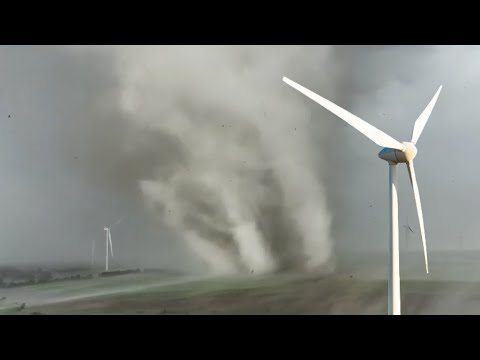
Ook in andere delen van de staat is schade gemeld door tornado's. In hoofdstad Des Moines braken windmolens doormidden en vlogen in brand. In meerdere steden waaide er puin door de straten.
De autoriteiten hadden vooraf al gewaarschuwd voor de kans op tornado's en zware stormen. Daarom sloten scholen al uit voorzorg eerder hun deuren en lag het openbare leven uren voor de tornado's al plat.
Het midwesten van de Verenigde Staten kampt al dagen met extreem weer. Onder meer in Kansas, Missouri en Oklahoma raakten mensen gewond door harde wind, tornado's en hagelstenen zo groot als honkballen.
Tornado Alley
Iowa maakt deel uit van de zogenoemde Tornado Alley: een gebied van zo'n acht staten in de VS waar regelmatig tornado's voorkomen. De meeste van deze tornado's zijn niet sterk.
Jaarlijks komen er in de VS gemiddeld zo'n duizend tornado's per jaar voor, vooral in april, mei en juni.
https://nos.nl/artikel/25(...)door-tornado-in-iowa
In de Amerikaanse staat Iowa zijn meerdere mensen omgekomen door een zware tornado. Ook zijn zeker twaalf personen gewond geraakt.
Vooral het kleine plaatsje Greenfield is hard getroffen. Het stadje met zo'n 2000 inwoners kreeg te maken met meerdere tornado's en een groot deel van de plaats werd verwoest. Volgens de lokale politie zijn de hulpdiensten nog steeds bezig met het zoeken naar slachtoffers, waardoor een exact dodental nog niet genoemd kan worden.
Ook in andere delen van de staat is schade gemeld door tornado's. In hoofdstad Des Moines braken windmolens doormidden en vlogen in brand. In meerdere steden waaide er puin door de straten.
De autoriteiten hadden vooraf al gewaarschuwd voor de kans op tornado's en zware stormen. Daarom sloten scholen al uit voorzorg eerder hun deuren en lag het openbare leven uren voor de tornado's al plat.
Het midwesten van de Verenigde Staten kampt al dagen met extreem weer. Onder meer in Kansas, Missouri en Oklahoma raakten mensen gewond door harde wind, tornado's en hagelstenen zo groot als honkballen.
Tornado Alley
Iowa maakt deel uit van de zogenoemde Tornado Alley: een gebied van zo'n acht staten in de VS waar regelmatig tornado's voorkomen. De meeste van deze tornado's zijn niet sterk.
Jaarlijks komen er in de VS gemiddeld zo'n duizend tornado's per jaar voor, vooral in april, mei en juni.
https://nos.nl/artikel/25(...)door-tornado-in-iowa
Bizar hoe smal het kan zijn ook, allerlei huizen waar ogenschijnlijk niks aan de hand is en waar de boompjes nog netjes staan, terwijl het huis van de buren totaal...nou ja, weg isquote:Op woensdag 22 mei 2024 08:05 schreef Drass het volgende:
https://x.com/bclemms/status/1793063922355826857
Weinig meer over van Greenfield
Greensburg 2007quote:
https://x.com/bclemms/status/1793063922355826857
Weinig meer over van Greenfield
Greenfield 2024
Its all in the name
wel nette opname, ja
Never Stop Exploring!
Life begins at the end of your comfort zone!
Follow me on Twitter: https://twitter.com/EdwinKr83 Instagram: https://www.instagram.com/edwinkr83/
Life begins at the end of your comfort zone!
Follow me on Twitter: https://twitter.com/EdwinKr83 Instagram: https://www.instagram.com/edwinkr83/
EF4 dus met krachtigste windstoten van 2024 tot nu toe
https://www.google.com/am(...)ster-damage-ef-4.amp
https://www.google.com/am(...)ster-damage-ef-4.amp

Zag dit op reed timmers live stream. Echt zieke beelden je zou bijna denken dat het uit een film komtquote:


quote:15 doden door stormen en tornado's in midden VS
In het midden van de Verenigde Staten zijn zeker 15 mensen omgekomen door meerdere stormen en tornado's. Ook raakten honderden mensen gewond en zitten bijna een half miljoen mensen zonder stroom.
Vooral in de staten Oklahoma, Arkansas, Missouri, Kentucky en Texas is de ravage groot. Daar zijn veel huizen volledig verwoest en wegen onbegaanbaar door omgewaaide bomen.
Weekend vrij
Veel Amerikanen hebben een lang weekend vrij en waren tijdens de stormen onderweg. Verschillende stopplaatsen langs de snelweg, waar mensen schuilden voor het weer, werden volledig verwoest. Deskundigen schatten dat de wind snelheden bereikte van ruim boven de 200 kilometer per uur.
Volgens meteorologen trekken de stormen nu naar het oosten van het land, in de richting van Alabama en tot aan New York. De autoriteiten roepen bewoners op om voorzorgsmaatregelen te nemen. Tientallen miljoenen mensen zullen met het noodweer te maken krijgen.
Het midden van de VS heeft deze maand meermaals zware stormen en tornado's te verduren gekregen. Vorige week kwamen er onder meer vijf mensen om in Iowa door een krachtige tornado. April kende het hoogste aantal tornado's ooit in de VS.


quote:Record-breaking tornado damage length for May 26 storms
The National Weather Service (NWS) office in Paducah, Kentucky announced on June 5 that storms on May 26, 2024, produced 16 tornadoes in their forecast area, resulting in a record-breaking 410 km (255 miles) of tornado damage.
During the month of May, there were two historic severe weather events in the NWS Paducah forecast area — on May 8 and 26.
The May 8 event shattered the previous single-day record for most warning issuances by the Paducah office.
A total of 16 tornadoes were observed in the NWS Paducah forecast area on May 26, resulting in a record-breaking 410 km (250 miles) of tornado damage.
The May 26 severe weather event also had the second-highest single-day warning issuance count in office history.
The NWS office in Paducah is responsible for monitoring weather conditions across 58 counties in parts of Kentucky, Illinois, Indiana, and Missouri. This extensive coverage includes major cities like Evansville, Hopkinsville, Owensboro, Carbondale, Cape Girardeau, and Paducah.
There were two historic severe weather events that impacted the region under their watch in May 2024.
The first occurred on May 8 when several rounds of storms occurred throughout a nearly 24-hour period beginning late evening on May 7. The most widespread damage occurred during the afternoon and evening of May 8 as multiple bowing segments and several supercells occurred.
9 tornadoes touched down while training storms resulted in flash flooding with rainfall totals of 50 to 100 mm (2 – 4 inches) in many areas, locally up to 127 – 152 mm (5 – 6 inches).
This event resulted in the single-day record for most warning issuances (Severe Thunderstorm Warning, Tornado Warning, and Flash Flood Warning) by the Paducah office of 117, shattering the old record of 71.
The second severe weather event occurred on May 26 when multiple rounds of severe thunderstorms occurred. The first was a bowing line crossing Southeast Missouri into Western Kentucky and far Southern Illinois from 05:00 to 10:00 LT, producing a wide swath of wind damage and several tornadoes.
Supercells formed near sunset producing several more tornadoes while a line of storms moved across the Quad State from 07:00 to 11:00 LT, bringing a second round of widespread wind.
At least 100 000 customers were without power across the Quad State region at the peak of this event. Flash flooding occurred with the morning and evening rounds of storms.
In their May 2024 Climate Summary, the office reported a preliminary number of 14 tornadoes, including 3 EF-3s. The May 26 event also had the second-highest single-day warning issuance count in office history, only behind the May 8 record.
However, on June 5, the office announced the number of tornadoes produced on May 26 rose to 16 — resulting in an ‘astounding’ 410 km (255 miles) of tornado damage.
This now marks a record-shattering length of tornado damage in their forecast area.
The previous record was 260 km (162 miles) of damage set on February 29, 2012.
The table below contains all events with 160+ km (100+ miles) of tornado damage, without mileage for parts of tornadoes that began or ended outside of any of the counties under their watch.


Een shelfcloud zoals wij eens in de zoveel jaar zien hier is al geweldig, maar supercells zoals daar in USA in the plains, die echte motherships... wat is dat een genot om naar te kijken zeg

Vandaag kans op tornado's die ontstaan uit de zware onweersbuien die behoren bij orkaan Debby.
quote:Tropical Storm Debby may produce a few tornadoes over parts of
Florida and extreme southern Georgia through early tomorrow morning
as it intensifies. Scattered thunderstorms may produce damaging
wind gusts across parts of Montana this evening.
v
'Fun' fact: bij deze tornado, Barnsdall dus, was Ewout Genemans in de omgeving (en de 'morning after' op locatie, onder meer bij het huis waar een dode viel).quote:
https://www.rtl.nl/boulev(...)rnados-heftige-storm

quote:Rare EF-3 tornado hits Palm Beach Gardens, Florida
A rare EF-3 tornado tore through the Avenir community in Palm Beach Gardens, Florida on October 9, 2024, as Hurricane “Milton” unleashed a tornado outbreak across Florida.
A powerful EF-3 tornado tore through Palm Beach Gardens on October 9, ripping off roofs and causing widespread damage. With winds of 225 km/h (140 mph), the tornado lifted a construction dumpster into the air and tossed it on top of a home in Regency Community at Avenir.
“I’ve never surveyed a tornado with this much damage and severity. EF-3 tornadoes are very rare in South Florida,” said NWS Meteorologist Robert Molleda. “It’s probably been many years since we’ve had an EF-3-rated tornado here in South Florida,” he added.
Several new homes in the Avenir community were damaged by the tornado which ripped off concrete block walls and large sections of the roofs from homes. People were seen putting tarpaulin over their damaged roofs once the storm had passed.
The tornado had a long track with its starting and end locations still unknown. The EF-3 rating of the tornado is still preliminary as it is based on just one neighborhood of Palm Beach Gardens which was among the hardest hit. A multi-day survey is needed to assign a final rating.
The tornado was part of a larger tornado outbreak triggered by Hurricane Milton, which made landfall near Siesta Key as a Category 3 hurricane at around 20:30 local time on October 9.


Moderate risk in december. Er zijn mensen live...
https://www.youtube.com/live/lKH3-cCS_iw?si=RNxoaeRCWex7ZVkw
https://www.youtube.com/live/lKH3-cCS_iw?si=RNxoaeRCWex7ZVkw
v
Wat daar prima kan in deze tijd van het jaarquote:Op zaterdag 28 december 2024 23:25 schreef Nattekat het volgende:
Er is zowaar ook serieus wat aan de gang schijnbaar
quote:At least 4 dead as severe weather outbreak wreaks havoc across Southeast U.S.
A severe weather outbreak wreaked havoc across the southeastern United States over the weekend, leaving at least four people dead, causing widespread destruction, and cutting power to thousands of homes and businesses on Sunday, December 29, 2024.
At least four people have been reported dead after a severe weather outbreak accompanied by strong winds and tornadoes ravaged the southeastern United States, leaving hundreds of thousands without power on Sunday and grounding some 600 flights.
Several tornadoes, ranging from EF-0 to EF-3, were reported across Mississippi, Texas, Arkansas, Louisiana, and other parts of the Southeast, starting Friday, December 27.
The tornadoes caused widespread damage across the affected regions, blowing off roofs, flipping vehicles, and downing trees and powerlines throughout the Southeast. Several trailer homes were overturned in Mississippi.
On Saturday, December 28, the NWS Storm Prediction Center received 45 tornado reports from the Southeast, with 19 of them occurring in Mississippi.
NWS Weather Prediction Center meteorologist Frank Pereira said that severe weather outbreaks of this magnitude so late in the year are fairly uncommon, but not unheard of.
A deadly EF-2 tornado between Liverpool and Hillcrest Village around 12:57 local time (LT) with peak winds of around 201 km/h (125 mph).
The twister had a maximum path width of 275 m (300 yards) and was on the ground for 14.1 km (8.78 miles), destroying multiple homes between Alvin and Liverpool and leaving substantial debris on parts of SH 35.
1 death and 5 injuries have been reported so far with this tornado.
Storm survey shows it tracked along Co Road 172 in rural Brazoria County into Hillcrest. EF-0 and EF-1 damage was observed along most of the tornado’s track. The most significant damage was surveyed at Walt Disney Elementary School, which suffered serious damage to the majority of its roof structure.
An EF-3 tornado was reported near Porter Heights, Texas at 12:05 LT, with a path length of over 16 km (10 miles) and peak winds reaching 225 km/h (140 mph).
The tornado had a maximum width of 1 500 m (1 675 yards) and was on the ground for 16.6 km (10.34 miles). The majority of its track showed high-end EF-1 and low-end EF-2 damage, with just one spot of EF-3 near the start.
A long-track EF-3 tornado struck Chambers County, Texas at 14:35 LT, injuring one person and covering a path length of around 35 km (22 miles), with peak winds of 222 km/h (138 mph).


Bekijk deze YouTube-videoquote:Seven tornadoes strike Oklahoma and Louisiana
Seven tornadoes were reported in Oklahoma and Louisiana on Tuesday, March 4, 2025, as severe storms moved over the region. The twisters ripped roofs off homes, destroyed outbuildings, and damaged numerous trees.
Five tornadoes struck Oklahoma on March 4, causing widespread damage across parts of the state. Four tornadoes were reported in Okmulgee County, while one was recorded in McIntosh County.
An EF-1 tornado struck near Henryetta at 06:06 local time (LT), lasting until 06:09 LT. It had peak winds of up to 160 km/h (100 mph) and a path length of 2.9 km (1.8 miles).
The tornado formed west of S 210 Road and south of E 111 Road. It moved northeast, uprooting multiple trees, damaging homes, and destroying outbuildings as it crossed Lake Road. The tornado dissipated east of Lake Road and north of Country Club Road.
Another EF-1 tornado struck Henryetta at 06:10 LT, lasting until 06:15 LT. It had a path length of approximately 5.3 km (3.3 miles) and peak winds of up to 153 km/h (95 mph).
The tornado formed south of New Lake Road and east of S 230 Road, snapping trees in the area. Moving northeast, it crossed I-40 and Holly Road, damaging outbuildings, before reaching Arbeka Road, where large tree limbs were snapped. It dissipated north of Holly Road and east of Arbeka Road.
The third EF-1 tornado struck near Morris at around 06:22 LT, lasting until 06:25 LT. It had peak winds of up to 153 km/h (95 mph) and a path length of 4.3 km (2.7 miles).
The tornado formed west of N 270 Road and north of Gun Club Road, causing an RV to roll over. It caused significant tree damage while moving east-northeast across N 280 Road, damaging a roof and snapping multiple power poles. It then crossed Smith Road, knocking down power poles and damaging a home. Continuing northeast across Highway 52, it snapped large tree limbs and damaged another home’s roof before dissipating.
Two EF-0 tornadoes were also reported in Oklahoma—one in Eram, Okmulgee County, and another in Checotah, McIntosh County. Both tornadoes caused some roof damage and snapped numerous tree limbs along their paths.

https://www.google.com/se(...)vid:p--T_HA79i8,st:0
Noord van Orlando. Weerstation tijdens live uitzending geraakt.
Noord van Orlando. Weerstation tijdens live uitzending geraakt.
Morgenavond/nacht en vooral zaterdagmiddag lijkt het flink te gaan spoken.
100.000 katjes
Fuck the EBU!
Fuck the EBU!

Als ik dit in Nederland zou zien, zou ik een noodpakket bij elkaar rapen en in de fietsenschuur gaan zitten. Als je er de ballen van begrijpt; dat vlakje rechtsboven laat de wind zien op x, y, z, a en b km hoogte. Supercellen vinden het leuk als dat lijntje een soort van rond gaat en ze vinden het al helemaal prachtig als het ook nog met een enorme versnelling vergezeld gaat op de lagere hoogtes.
100.000 katjes
Fuck the EBU!
Fuck the EBU!


Morgen alvast de opwarmer.

Zal me echt niets verbazen als deze van zaterdag nog paars gaat kleuren.
100.000 katjes
Fuck the EBU!
Fuck the EBU!
Gaat heel naar worden komende dagen, misschien wel historisch. Ik zie al wat filmpjes met stofstormen in Texas, met daarbij enorme droogte en dus kans op branden. Ergste in de staten oost daarvan moet nog komen uiteraard.
Één enorm gelukje is dat er van de week al een flink front is geweest die de instabiliteit heeft weggeblazen. Als dat er ook nog bovenop was gekomen, hadden we aan de vooravond van een historische uitbraak gestaan.quote:
Gaat heel naar worden komende dagen, misschien wel historisch. Ik zie al wat filmpjes met stofstormen in Texas, met daarbij enorme droogte en dus kans op branden. Ergste in de staten oost daarvan moet nog komen uiteraard.
100.000 katjes
Fuck the EBU!
Fuck the EBU!
Precies,
Precies, scheelt iets. Maar eens volgen de komende dagen. Toch wakker snachts, want heb een baby van 5mnd. Rustig Ryan Hall volgen.quote:
[..]
Één enorm gelukje is dat er van de week al een flink front is geweest die de instabiliteit heeft weggeblazen. Als dat er ook nog bovenop was gekomen, hadden we aan de vooravond van een historische uitbraak gestaan.
zegt ook wel veel dat het voor een day two outlook pas 1x eerder is gebeurd. 2012
Never Stop Exploring!
Life begins at the end of your comfort zone!
Follow me on Twitter: https://twitter.com/EdwinKr83 Instagram: https://www.instagram.com/edwinkr83/
Life begins at the end of your comfort zone!
Follow me on Twitter: https://twitter.com/EdwinKr83 Instagram: https://www.instagram.com/edwinkr83/
knake tweets
Never Stop Exploring!
Life begins at the end of your comfort zone!
Follow me on Twitter: https://twitter.com/EdwinKr83 Instagram: https://www.instagram.com/edwinkr83/
Life begins at the end of your comfort zone!
Follow me on Twitter: https://twitter.com/EdwinKr83 Instagram: https://www.instagram.com/edwinkr83/