WKN Weer, Klimaat en Natuurrampen
Lees alles over het onstuimige weer op onze planeet, volg orkanen en tornado's, zie hoe vulkanen uitbarsten en hoe Moeder Aarde beeft bij een aardbeving. Alles over de verwoestende kracht van onze planeet en tal van andere natuurverschijnselen.


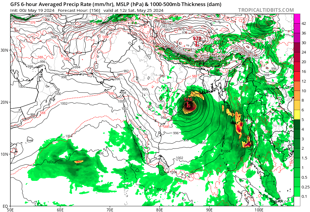
Aan de hoeveelheid vocht bij Sri Lanka zou je verwachten dat er een orkaan tot ontwikkeling komt. Tot nu zijn het alleen GFS en het AI model van EC wat iets laten zien. Deze twee modellen laten een orkaan zien boven de Golf van Bengalen die uiteindelijk landfall maakt ergens op de oostkust van India. Nog even afwachten wat de andere modellen gaan laten zien.
De meeste modellen laten nu een systeem boven de golf van Bengalen zien. De kans op landfall is groot maar hoe en waar blijft nog even afwachten. GFS laat de laagste kerndruk zien, 946mb wat vergelijkbaar is met een categorie 3.
[ Bericht 14% gewijzigd door #ANONIEM op 19-05-2024 10:07:31 ]
[ Bericht 14% gewijzigd door #ANONIEM op 19-05-2024 10:07:31 ]

Dat gaat een pittig seizoen worden.
And what rough beast, its hour come round at last,
Slouches towards Bethlehem to be born?
Slouches towards Bethlehem to be born?

Gaat dit de eerste worden? Alleen gfs laat dit nog zien. Een gebied wat via de Caribische zee boven de Atlantische Oceaan terecht komt...

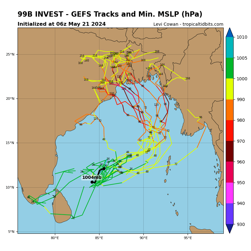
De verwachting voor de Golf van Bengalen ziet er momenteel echt heel slecht uit. Steeds meer modellen voorspellen nu dat de orkaan richting Bangladesh zal trekken. Hoewel het nog ver weg is en er ook nog steeds een kans bestaat dat de orkaan India zal treffen, wijzen de trends nu meer in de richting van Bangladesh of Myanmar.
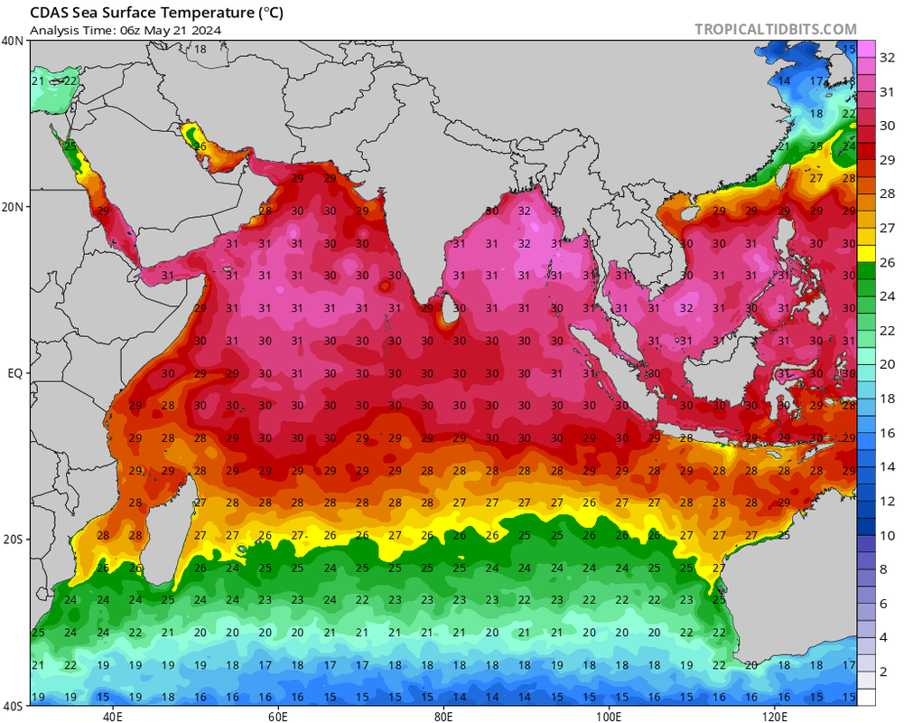
In de regio worden momenteel watertemperaturen van 32 graden gemeten, wat ideaal is voor de ontwikkeling van zeer zware orkanen. Een bijkomend probleem is dat de orkaan waarschijnlijk aan land zal komen tijdens springtij, waardoor het waterpeil nog veel hoger zal zijn dan normaal. Dit kan de impact van de orkaan nog meer verergeren.
[ Bericht 14% gewijzigd door #ANONIEM op 21-05-2024 17:49:52 ]
Zoek de verschillen. Zowel GFS als ICON laten een categorie 3 zien bij landfall. Dit zal dan gebeuren in Bangladesh of India.
GFS
ICON
[ Bericht 23% gewijzigd door #ANONIEM op 22-05-2024 08:14:44 ]
GFS

ICON

[ Bericht 23% gewijzigd door #ANONIEM op 22-05-2024 08:14:44 ]
Dit weekend al zo te zien?quote:Op woensdag 22 mei 2024 08:13 schreef aloa het volgende:
Zoek de verschillen. Zowel GFS als ICON laten een categorie 3 zien bij landfall. Dit zal dan gebeuren in Bangladesh of India.
GFS
[ link | afbeelding ]
ICON
[ link | afbeelding ]
And what rough beast, its hour come round at last,
Slouches towards Bethlehem to be born?
Slouches towards Bethlehem to be born?


[ Bericht 34% gewijzigd door Resistor op 23-05-2024 20:28:34 ]
Als het niet met een hamer te repareren is, is het een elektrisch probleem.

quote:All signs are pointing to a very busy hurricane season in the Atlantic Ocean.
The U.S. National Oceanic and Atmospheric Administration (NOAA) has just released its annual hurricane season forecast and is projecting 17 to 25 storms, the most it has ever forecasted.
Of those storms, eight to 13 are expected to become hurricanes, but it's still too early to tell if they will hit Atlantic Canada.
https://www.cbc.ca/news/c(...)tlook-2024-1.7212351
[ Bericht 40% gewijzigd door #ANONIEM op 23-05-2024 23:59:29 ]

[youtube]https://www.youtube.com/live/qw_FO-qj2wo?si=Xxx47dtAa1w-7gkS[/youtube]
Live tornado in Oklahoma
[ Bericht 34% gewijzigd door Libris op 24-05-2024 06:18:54 ]
Live tornado in Oklahoma
[ Bericht 34% gewijzigd door Libris op 24-05-2024 06:18:54 ]
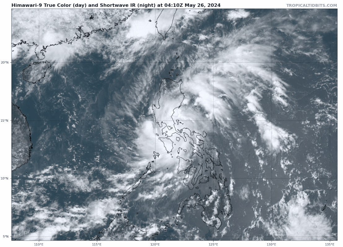
Tropical Storm EWINIAR teistert de Filipijnen momenteeel en zet hierna koers richting Japan. maar lijkt hier ver zuidelijk onderlangs te trekken.


Dit zou de eerste kunnen worden voor het Atlantische Seizoen. Een invest die zal ontstaan boven de Caribische zee en daarna via Cuba de golf van Mexico in duikt. Ver weg nog, maar wel iets om in de gaten te houden.

Is dat een gevolg van die enorme blob die nu van de Afrikaanse kust af komt?quote:
Dit zou de eerste kunnen worden voor het Atlantische Seizoen. Een invest die zal ontstaan boven de Caribische zee en daarna via Cuba de golf van Mexico in duikt. Ver weg nog, maar wel iets om in de gaten te houden.
[ link | afbeelding ]

Volgens mij niet.quote:Op woensdag 5 juni 2024 16:08 schreef Frutsel het volgende:
[..]
Is dat een gevolg van die enorme blob die nu van de Afrikaanse kust af komt?
[ afbeelding ]
Lijkt eerder in de buurt van Panama/Costa Rica te ontstaan. Daar is wel een draaiing te zien in de hoeveelheid vocht.
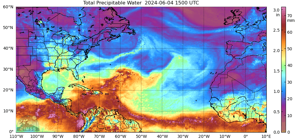
[ Bericht 4% gewijzigd door #ANONIEM op 05-06-2024 16:53:47 ]
quote:AccuWeather meteorologists have been monitoring the northwestern Caribbean for tropical activity for a couple of weeks. Indications are that torrential downpours that develop in the Gulf of Mexico and waters northeast of Florida have the potential to evolve into one or more tropical systems beginning during the second week of June.
While there is no sign of a tropical system rapidly forming and intensifying in the coming days, weak disturbances have recently caused trouble in the form of torrential downpours and flash flooding in some of the northern islands of the Caribbean.
https://www.accuweather.c(...)-by-mid-june/1657147


Het is nog onduidelijk wat er precies gaat gebeuren in de Golf maar er lijkt een gigantische hoeveelheid regen te gaan vallen. Vooral in Florida kan er zeer veel neerslag vallen de komende week. De modellen zijn het nog niet helemaal eens over de vorming van een tropische storm die een naam krijgt.
quote:Forecasts for tropical activity in the Gulf of Mexico next week are rather inconsistent, but the situation will likely be governed by some broad themes:
🌀 A northward surge of tropical moisture from the western Caribbean into the Gulf of Mexico is expected beginning mid-week.
🌀 An upper-level trough over the central gulf coast will aid in ushering moisture northward and organizing thunderstorm activity, leading to possible formation of a broad area of low pressure in the gulf. The upper-level trough would also impose vertical shear and dry air on the developing low, most likely resulting in a sloppy-joe-style storm characteristic of June.
🌀 At a minimum, a multi-day period of heavy rain is likely for Cuba, parts of Florida, and the Bahamas as tropical moisture gradually encroaches northward, possibly creating flooding hazards. An organized, strong tropical cyclone with high winds isn't particularly likely in this setup, but we won't know for sure until a storm begins forming, if one indeed does next week.
https://x.com/TropicalTid(...)4z3dBFHVec38_3g&s=19
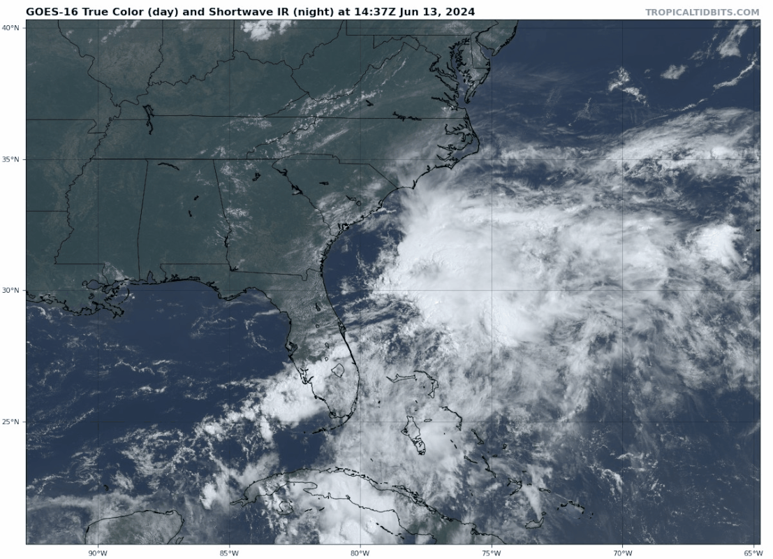
Dit kan de eerste storm met een naam worden voor het Atlantisch orkaanseizoen. Deze invest zorgt eerst voor zeer veel neerslag in Florida en trekt daarna de Atlantische Oceaan op.
Momenteel laten de modellen nog niet heel veel activiteit zien van dit systeem.
Momenteel laten de modellen nog niet heel veel activiteit zien van dit systeem.

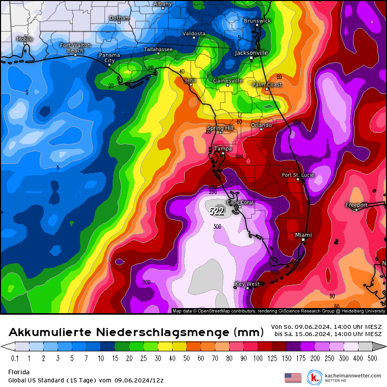
Florida staat zo ongeveer onder water. Er is hier gigantisch veel regen gevallen de afgelopen dagen. Dit tropische systeem trekt nu de Atlantische oceaan op en kan zich mogelijk ontwikkelen tot de eerste storm met een naam. Dat zal dan Alberto worden.
De invest is nu 20%
De invest is nu 20%
Zuid-Florida onder water: Tropische regenstorm laat 50 centimeter regen vallen in 24 uur
En momenteel trekt er nog steeds een gebied met veel neerslag over het zuiden van Florida.
En momenteel trekt er nog steeds een gebied met veel neerslag over het zuiden van Florida.
quote:Vehicles were stranded on roads that were transformed into rivers across South Florida on Wednesday, including around Fort Lauderdale and Miami, as a tropical deluge inundated the region.
A state of emergency has been declared in Broward, Collier, Lee, Miami-Dade and Sarasota counties due to Wednesday's flooding.
Widespread flooding from a tropical rainstorm was reported across the area, with some of the worst conditions occurring north of Miami, where a rare flash flood emergency was issued by the National Weather Service. The "particularly dangerous situation" started to unfold ahead of the Wednesday evening commute.
https://www.accuweather.c(...)-in-24-hours/1658887
Weer een regen event op komst. Dit keer voor de andere kant van de Golf van Mexico. Nog steeds geen storm met een naam, maar deze tropische systemen zorgen ook zonder naam voor extreme hoeveelheden aan neerslag.
Dit zou overigens wel de eerste naam kunnen worden.
Dit zou overigens wel de eerste naam kunnen worden.
quote:1. Southwestern Gulf of Mexico:
A broad area of low pressure is forecast to form over the
southwestern Gulf of Mexico early next week. Environmental
conditions appear conducive for gradual development of this system,
and a tropical depression could form by the middle part of next week
while the system moves slowly westward or west-northwestward.
Regardless of development, several days of heavy rainfall are
expected across portions of southern Mexico and Central America.
These rains are likely to cause life-threatening flooding and flash
flooding.
* Formation chance through 48 hours...low...near 0 percent.
* Formation chance through 7 days...medium...50 percent.
Midden Amerika krijgt een enorme hoeveelheid regen de komende dagen.
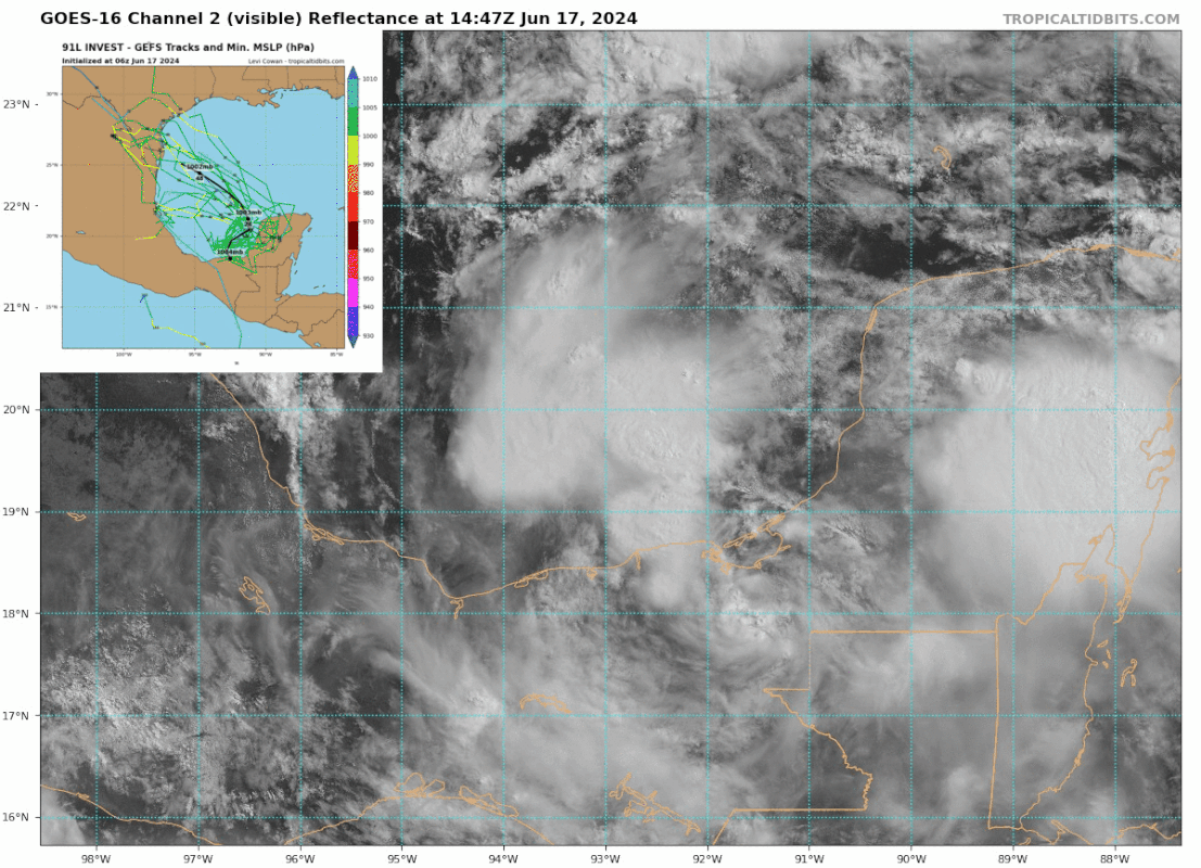
20% kans nu op een tropiche storm voor de westkant van Mexico.
In de Golf kan mogelijk de eerste storm met een naam ontstaan. Meerdere modellen laten dit zien nu.
Rond midden Amerika draait een enorm gebied met heel veel vocht
Meerdere modellen laten een storm zien voor de westkant van de Golf van Mexico
[ Bericht 1% gewijzigd door #ANONIEM op 16-06-2024 11:08:49 ]
20% kans nu op een tropiche storm voor de westkant van Mexico.
In de Golf kan mogelijk de eerste storm met een naam ontstaan. Meerdere modellen laten dit zien nu.

Rond midden Amerika draait een enorm gebied met heel veel vocht

Meerdere modellen laten een storm zien voor de westkant van de Golf van Mexico

[ Bericht 1% gewijzigd door #ANONIEM op 16-06-2024 11:08:49 ]
De watertemperatuur in de Golf van Mexico ligt momenteel ver boven het normale niveau. In vrijwel de gehele Golf bedraagt de temperatuur nu al rond de 30 graden Celsius. Dit is uitzonderlijk hoog voor de maand juni.
Deze ongewoon hoge temperaturen hebben grote gevolgen. Een van de belangrijkste effecten is de toename van de hoeveelheid vocht in de atmosfeer. Dit hebben we al waargenomen in Florida, waar hevige regenval en overstromingen plaatsvonden. Deze omstandigheden vinden nu ook plaats in Midden-Amerika.
Deze ongewoon hoge temperaturen hebben grote gevolgen. Een van de belangrijkste effecten is de toename van de hoeveelheid vocht in de atmosfeer. Dit hebben we al waargenomen in Florida, waar hevige regenval en overstromingen plaatsvonden. Deze omstandigheden vinden nu ook plaats in Midden-Amerika.


Het gebied boven de golf is nu 60% en zal verder toenemen (7daagse is nu 70%).
Deze storm zal landfall maken ergens tussen het noorden van Mexico en Texas.
Deze storm zal landfall maken ergens tussen het noorden van Mexico en Texas.

Invest 90E is opgenomen in het systeem wat ontstaan is boven de Golf van Mexico. De kans is groot dat dit de eerste storm met een naam gaat worden (Alberto). Nu is het 'Potential Tropical Cyclone ONE'.
Er is een waarschuwing voor een tropische uitgegeven voor een groot deel van de kust van Mexico en Texas.
Er is een waarschuwing voor een tropische uitgegeven voor een groot deel van de kust van Mexico en Texas.


![[Tuesday] Potential Tropical Cyclone One Bringing Flooding Risks to Texas and Mexico](https://i.ytimg.com/vi/GOh2mXNw0HU/0.jpg)
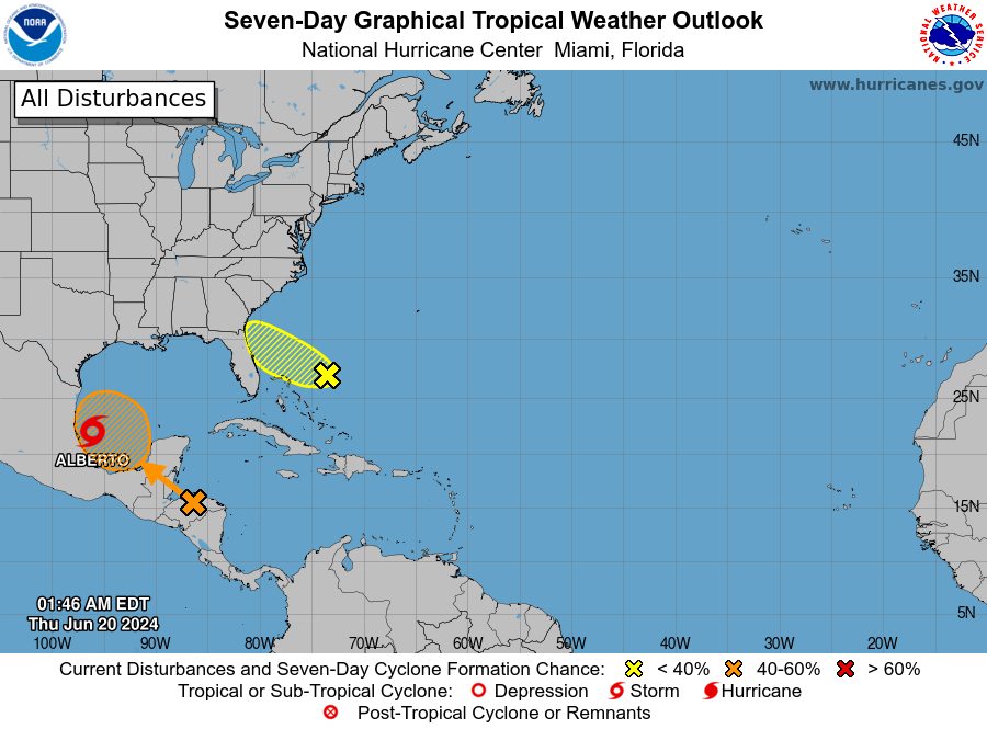
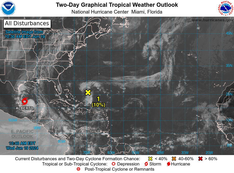
De eerste storm met een naam is een feit.
[ Bericht 0% gewijzigd door #ANONIEM op 19-06-2024 17:26:45 ]
[ Bericht 0% gewijzigd door #ANONIEM op 19-06-2024 17:26:45 ]
Na Alberto lijkt er nog een tropische depressie te onstaan in de Golf. Zo ongeveer in precies hetzelfde gebied ook. Dat zou betekenen dat ze nog een keer een hoeveelheid regen gaan krijgen...