WKN Weer, Klimaat en Natuurrampen
Lees alles over het onstuimige weer op onze planeet, volg orkanen en tornado's, zie hoe vulkanen uitbarsten en hoe Moeder Aarde beeft bij een aardbeving. Alles over de verwoestende kracht van onze planeet en tal van andere natuurverschijnselen.


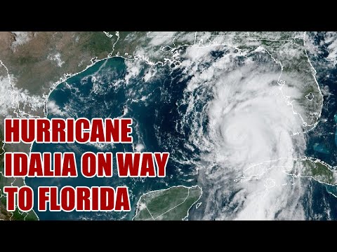
Tropische storm Idalia
Al een aantal dagen zijn onweersbuien actief tussen het zuid-oosten van Cuba en Honduras/Yucatan (Mexico). Vandaag zijn deze buien samengekomen tot tropische storm Idalia. De komende dagen trekt deze storm richting het noorden en komt in de Golf van Mexico terecht. De relatief warme zeewatertemperaturen in dit gebied zullen naar verwachting bijdragen aan de versterking van de storm. Er bestaat zelfs een reële mogelijkheid dat de storm zich zal ontwikkelen tot een zware orkaan (categorie 3 of meer).
De verwachte koers
Zie voor meer informatie over orkanen: WKN / [ACTUEEL] Hurricane Season 2023
Al een aantal dagen zijn onweersbuien actief tussen het zuid-oosten van Cuba en Honduras/Yucatan (Mexico). Vandaag zijn deze buien samengekomen tot tropische storm Idalia. De komende dagen trekt deze storm richting het noorden en komt in de Golf van Mexico terecht. De relatief warme zeewatertemperaturen in dit gebied zullen naar verwachting bijdragen aan de versterking van de storm. Er bestaat zelfs een reële mogelijkheid dat de storm zich zal ontwikkelen tot een zware orkaan (categorie 3 of meer).
De verwachte koers

quote:TAMPA - Tropical Storm Idalia formed in the Caribbean Sea on Sunday as forecasters grew increasingly confident that the eventual hurricane could bring significant impacts to Florida later this week.
As of the National Hurricane Center’s midday update, the newly named Idalia was sitting between the Yucatan Peninsula and Cuba with winds of 40 mph. The storm is not moving much but is slowly strengthening and becoming better organized, soaking the region with heavy rain and gusty winds.
With high pressure to the north and Hurricane Franklin to its east, the system still won’t move much in the next 24 hours. But eventually, forecasters expect the storm to begin moving north into the Gulf of Mexico.
https://www.fox13news.com(...)ack-forecast-florida

Zie voor meer informatie over orkanen: WKN / [ACTUEEL] Hurricane Season 2023

Aan de temperatuur van het zeewater zal het niet liggen. De gehele golf van Mexico zit momenteel boven de 30 graden. Wat brandstof is voor orkanen.

Is er ook iets bekend van relatie zeewater temp en hoeveelheid regen er uit zo'n storm kan vallen? Je ziet nu ook al een paar keer rond de Middellandse Zee dit jaar dat er enorm veel regen valt bij stormen.
De warmte speelt zeker een rol ja. Uiteraard ook de treksnelheid van de orkaan. Hoe langzamer, hoe meer neerslag.quote:Op zondag 27 augustus 2023 20:13 schreef George_of_the_Jungle het volgende:
Is er ook iets bekend van relatie zeewater temp en hoeveelheid regen er uit zo'n storm kan vallen? Je ziet nu ook al een paar keer rond de Middellandse Zee dit jaar dat er enorm veel regen valt bij stormen.
En die warmte van het water heeft geen duidelijke relatie met treksnelheid vermoed ik? Zag vandeweek wel dat er wel nog een aantal systemen in ontwikkeling zijn op de Atlantische oceaan.quote:Op zondag 27 augustus 2023 20:24 schreef aloa het volgende:
[..]
De warmte speelt zeker een rol ja. Uiteraard ook de treksnelheid van de orkaan. Hoe langzamer, hoe meer neerslag.
Cuba heeft ondertussen een orkaanwaarschuwing.
HWRF laat deze orkaan uitgroeien tot een cat 4 (939 mb). Het nieuwe model (HAFS-B) laat een nog lagere kerndruk zien van 932 mb.
[ Bericht 4% gewijzigd door #ANONIEM op 28-08-2023 17:24:50 ]
HWRF laat deze orkaan uitgroeien tot een cat 4 (939 mb). Het nieuwe model (HAFS-B) laat een nog lagere kerndruk zien van 932 mb.

[ Bericht 4% gewijzigd door #ANONIEM op 28-08-2023 17:24:50 ]
Het is ook nog volle maan op donderdag. Geen springtij, maar het water is dan ook al een stuk hoger dan normaal.
Het is trouwens wel een supermaan die dag, wat wil zeggen dat de maan dichter bij de aarde staat, waardoor de zee bij vloed sowieso hoger zal zijn dan bij een normale volle maan.
[ Bericht 24% gewijzigd door #ANONIEM op 28-08-2023 17:31:27 ]
Het is trouwens wel een supermaan die dag, wat wil zeggen dat de maan dichter bij de aarde staat, waardoor de zee bij vloed sowieso hoger zal zijn dan bij een normale volle maan.
[ Bericht 24% gewijzigd door #ANONIEM op 28-08-2023 17:31:27 ]
Zoals het er nu uit ziet is de timing van landfall bijna perfect, tijdens eb en ruim na de piek van de volle maan. Dan werkt het juist in je voordeel, want het water staat lekker laag. En tot de volgende nacht is springtij ook geen zorg.quote:
Het is ook nog volle maan op donderdag. Geen springtij, maar het water is dan ook al een stuk hoger dan normaal.
Het is trouwens wel een supermaan die dag, wat wil zeggen dat de maan dichter bij de aarde staat, waardoor de zee bij vloed sowieso hoger zal zijn dan bij een normale volle maan.
100.000 katjes
Fuck the EBU!
Fuck the EBU!
Ik zag DeSantis deze week de noodtoestand afkondigen waarbij iemand sceptisch grapte: waarom dat... weet hij meer dan wij?
En nu major hurricane? Toch goed gezien... lol
En nu major hurricane? Toch goed gezien... lol

Niet vergeten vast te ankeren.quote:Op maandag 28 augustus 2023 22:44 schreef devzero het volgende:
* devzero gaat de zandzakken alvast maar vullen
100.000 katjes
Fuck the EBU!
Fuck the EBU!
Ligt daar een kerncentrale netjes aan de kust. Ook prachtige dorpjes die compleet overspoeld gaan worden..
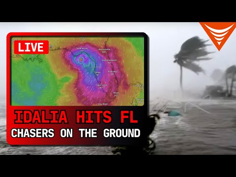
quote:Idalia strengthening, forecast to impact Florida as Category 2 or 3 hurricane
Tropical Storm “Idalia” formed in the Caribbean Sea on Sunday, August 27, 2023, as the 10th named storm of the 2023 Atlantic hurricane season. The system is still strengthening and is expected to make landfall in Florida as a Category 2 or 3 hurricane on Wednesday, August 30.
Idalia is forecast to become a hurricane by the time it reaches the southeastern Gulf of Mexico, and it could be near or at major hurricane strength when it reaches the Gulf coast of Florida. The risk continues to increase for a life-threatening storm surge and hurricane-force winds along portions of the west coast of Florida and the Florida Panhandle beginning as early as Tuesday. Storm surge and hurricane watches are in effect for portions of the west coast of Florida and the coast of the Florida Panhandle, and residents in these areas should monitor updates to the NHC forecast and follow any advice given by local officials.
Scattered flash and urban flooding is expected across portions of the west coast of Florida, the Florida Panhandle, and southern Georgia late Tuesday night through Wednesday. Heavy rainfall may lead to flash flooding across portions of the Carolinas Wednesday into Thursday.
Hurricane-force winds are expected across portions of far western Cuba late Monday. Heavy rainfall is expected across portions of eastern Yucatan and western Cuba and may produce areas of flash and urban flooding as well as landslides across western Cuba.
At 06:00 UTC on August 28, the center of Tropical Storm “Idalia” was located about 245 km (150 miles) S of the western tip of Cuba. It had maximum sustained winds of 95 km/h (60 mph). At the time, Idalia was nearly a stationary system with a minimum central pressure of 990 hPa.
A motion toward the north-northeast and north is expected to begin later today, bringing the center of Idalia over the extreme southeastern Gulf of Mexico by tonight (LT). Idalia will then continue on a northward or north-northeastward path over the eastern Gulf of Mexico on Tuesday and reach the Gulf coast of Florida on Wednesday.
Strengthening is forecast, and Idalia is expected to become a hurricane later today. The system is likely to be near or at major hurricane intensity when it reaches the Gulf Coast of Florida.
On August 26, Florida Governor Ron DeSantis declared a state of emergency for 33 Gulf Coast counties in advance of the storm. The next day, a hurricane watch was issued for much of the west coast of Florida.

Hier een aantal webcams:
https://hernando-beach-gulf-mm53.click2stream.com/
[ Bericht 18% gewijzigd door #ANONIEM op 29-08-2023 15:54:33 ]
https://hernando-beach-gulf-mm53.click2stream.com/


[ Bericht 18% gewijzigd door #ANONIEM op 29-08-2023 15:54:33 ]
Landfall nog steeds verwacht bij Alligator Point...
https://fetchthewave.com/alligator-point-florida/

https://fetchthewave.com/alligator-point-florida/
nou... Idalia gaat daar gehoor aan geven...quote:Aligator Point, Florida, The Best Hidden Beach Town to Visit in 2023

Het is een mooi plaatsje hoor. Naja, na morgen kunnen we misschien wel zeggen, was een mooi plaatsjequote:
Landfall nog steeds verwacht bij Alligator Point...
https://fetchthewave.com/alligator-point-florida/
[..]
nou... Idalia gaat daar gehoor aan geven...


Paar alligators die kilometers verderop terecht komen enzoquote:Op dinsdag 29 augustus 2023 15:58 schreef devzero het volgende:
[..]
Het is een mooi plaatsje hoor. Naja, na morgen kunnen we misschien wel zeggen, was een mooi plaatsje
En welke koers gaat het worden als deze weer in de Atlantische oceaan terecht komt. Een aantal modellen laten het weer terugkeren naar de oostkust van Florida, waarna de orkaan wederom in de Golf terecht komt.
Dat zou wel krankzinnig zijnquote:
En welke koers gaat het worden als deze weer in de Atlantische oceaan terecht komt. Een aantal modellen laten het weer terugkeren naar de oostkust van Florida, waarna de orkaan wederom in de Golf terecht komt.
Nog een webcam:
https://webcams.windy.com/webcams/stream/1689101443
https://www.oceankey.com/key-west-webcam/
[ Bericht 29% gewijzigd door #ANONIEM op 29-08-2023 18:41:51 ]
https://webcams.windy.com/webcams/stream/1689101443
https://www.oceankey.com/key-west-webcam/
[ Bericht 29% gewijzigd door #ANONIEM op 29-08-2023 18:41:51 ]
Het enige voordeel van deze orkaan is dat de treksnelheid vrij hoog ligt. Hierdoor zal er minder neerslag vallen (uiteraard nog wel genoeg om voor overstromingen en landverschuivingen te zorgen).
Inmiddels zijn er evacuaties aan de gang en worden scholen gesloten...
[ Bericht 1% gewijzigd door #ANONIEM op 29-08-2023 18:20:59 ]
Inmiddels zijn er evacuaties aan de gang en worden scholen gesloten...
De verwachte neerslag (10 inches = 254 mm)quote:As the storm makes its way to Florida, preparations could be seen across the state. Here’s the latest:
• Evacuations in at least 22 counties: Baker, Citrus, Dixie, Franklin, Gilchrist, Gulf, Hernando, Hillsborough, Jefferson, Lafayette, Levy, Madison, Manatee, Marion, Pasco, Pinellas, Sarasota, Suwannee, Taylor, Union, Volusia and Wakulla counties have all issued evacuation orders, some mandatory. State tolls are waived in Citrus, Hernando, Hillsborough, Lake, Pasco, Pinellas and Sumter counties, DeSantis said Tuesday.
• Air and train travel halted: Major airlines have canceled hundreds of flights as Tampa International Airport suspended commercial operations Tuesday and St. Pete-Clearwater International Airport Terminal building is set to close Tuesday afternoon. Amtrak has canceled at least 12 East Coast routes and is modifying others.
• Schools close: 42 school districts have announced closures over the next two days, along with 16 state colleges and seven universities, DeSantis said Tuesday.
• Emergencies declared: DeSantis expanded an emergency declaration to 46 of 67 Florida counties on Monday morning. Several local jurisdictions have also declared emergencies. North Carolina also declared a state of emergency, Gov. Roy Cooper said Tuesday.
• National Guard activated: More than 5,500 Guard members have been activated for storm response. Florida officials also activated eight search and rescue teams and stationed over 580 rescue personnel to help, officials said Tuesday.
• US Navy ships begin leaving: Navy ships have begun leaving Florida ahead of Idalia’s landfall, the Navy said Monday.
• Power outages expected: DeSantis told residents to prepare to be without power. “If you are in the path of the storm, you should expect power outages so please prepare for that,” the governor told residents Sunday.
• Hospital system suspending services: Patients will be transferred from at least three hospitals: HCA Florida Pasadena Hospital, HCA Florida Trinity West Hospital and HCA Florida West Tampa Hospital.

[ Bericht 1% gewijzigd door #ANONIEM op 29-08-2023 18:20:59 ]


Idalia is er bijna.. Dat wordt weer een boel schade.
And what rough beast, its hour come round at last,
Slouches towards Bethlehem to be born?
Slouches towards Bethlehem to be born?

Lijkt idd op randje te zitten... kans is groot dat er nog een upgrade komt in het komende half uurquote:
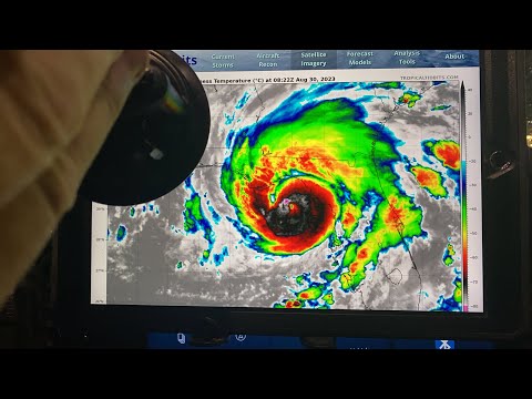
Rand categorie 4 nu. Kerndruk is 944 mb.
941 mb nu. Dan is het een cat 4.quote:
[..]
Lijkt idd op randje te zitten... kans is groot dat er nog een upgrade komt in het komende half uur
quote:4:00 AM EDT Wed Aug 30
Location: 28.9°N 84.1°W
Moving: NNE at 17 mph
Min pressure: 941 mb
Max sustained: 125 mph
En om dan nog maar te bedenken dat modellen tot gisteren voor een lage cat 3 gingen.quote:
[..]
941 mb nu. Dan is het een cat 4.
[..]
100.000 katjes
Fuck the EBU!
Fuck the EBU!
Officieel nog niet volgens mij maar zal niet lang meer duren?quote:
[..]
941 mb nu. Dan is het een cat 4.
[..]
Over 12 uur is het springtij, schijnbaar valt het daar precies samen met volle maan. Nu is het vloed, maar het eb tussen nu en dat springtij is amper eb te noemen. Wanneer werd de piek van die stormvloed verwacht?quote:
100.000 katjes
Fuck the EBU!
Fuck the EBU!


Gewoon nog op het strand zitten met een tentje 
Twee voordelen: Ze verplaatst vrij snel, en het zwaarste deel lijkt Tampa te missen.
Twee voordelen: Ze verplaatst vrij snel, en het zwaarste deel lijkt Tampa te missen.

quote:
[ afbeelding ]
3,5 tot 5 meter, dat is hoog.

Perry, FL
How do we turn this world-class fuck-up into a world-class learning experience?

Liever wat stormschade dan stormschade én waterschade.quote:
[..]
Nu nog de vraag of dat de wind ook doorstaat
100.000 katjes
Fuck the EBU!
Fuck the EBU!

Die is zijn ramen aan het dichttimmeren gok ikquote:
Wachten tot Steve weer live is. Hopelijk met net zoveel energie als tijdens de trump mugshot.

I'd rather be somewhere else, right now.quote:
How do we turn this world-class fuck-up into a world-class learning experience?

Had nooit verwacht zo aandachtig naar een stream van een simpel schuurtje te kijken.
100.000 katjes
Fuck the EBU!
Fuck the EBU!
Ik vraag me af of dat de trap is die ik op de schuurstream voorbij zag drijven.quote:
[..]
Zou bijzonder zijn als onderstaande een zelfde soort huis zou zijn
[ twitter ]
[ twitter ]
100.000 katjes
Fuck the EBU!
Fuck the EBU!
Oh, de stream zelf nokt er ook meteen mee. Snap ik ook wel, uit respect voor het weggespoelde schuurtje.
100.000 katjes
Fuck the EBU!
Fuck the EBU!


971 mb...dat is vergelijkbaar met een cat2.
Systeem ligt nu net over de helft van Florida met nog een windsnelheid van boven de 150 km.
Systeem ligt nu net over de helft van Florida met nog een windsnelheid van boven de 150 km.
Dit zie je niet vaak. De oostkust krijgt een orkaanwaarschuwing voor een systeem wat uit de Golf komt...
En een groot gedeelt een tropische stormwaarschuwing.
En een groot gedeelt een tropische stormwaarschuwing.

Zou dat niet iets te maken hebben met het feit dat het ook niet zo vaak gebeurt dat een orkaan überhaupt op die plek landfall maakt?quote:
Dit zie je niet vaak. De oostkust krijgt een orkaanwaarschuwing voor een systeem wat uit de Golf komt...
En een groot gedeelt een tropische stormwaarschuwing.
[ afbeelding ]
Vond het wel interessant dat er een mogelijkheid was dat ie gewoon weer omkeert voor ronde 2.
100.000 katjes
Fuck the EBU!
Fuck the EBU!
En wat zijn we weer verbaasd dat al die houten krotten zo kapot waaien
Als iedereen aan zichzelf denkt wordt er aan iedereen gedacht.
Op fietsen zonder bende kwam'm zie schooieren um spek
Op fietsen zonder bende kwam'm zie schooieren um spek
Ze maken wel vaker landfall op Florida...misschien door de hoeveelheid energie (door het veel te warme water).quote:
[..]
Zou dat niet iets te maken hebben met het feit dat het ook niet zo vaak gebeurt dat een orkaan überhaupt op die plek landfall maakt?
Vond het wel interessant dat er een mogelijkheid was dat ie gewoon weer omkeert voor ronde 2.
De optie dat ie weer terugkeert is er volgens mij wel uit nu, maar ze kunnen rare routes maken
Die wilde gewoon even zeker maken dat de klus geklaard was.quote:
[..]
Ze maken wel vaker landfall op Florida...misschien door de hoeveelheid energie (door het veel te warme water).
De optie dat ie weer terugkeert is er volgens mij wel uit nu, maar ze kunnen rare routes makenBij Australië ooit een die gewoon precies hetzelfde pad weer terugnam.
100.000 katjes
Fuck the EBU!
Fuck the EBU!
ICON laat Idalia in de buurt van Bermuda stagneren, waardoor dit eiland een enorme hoeveelheid neerslag kan verwachten.
Franklin is nog niet verdwenen of de volgende dient zich al weer aan in Bermuda.
Ik zeg maar zoo, dat is korter dan dierentuin
Ik verbaas me er altijd over dat die grote reclameborden en de auto's gewoon blijven staan.quote:
<a href="https://forum.fok.nl/topic/1321859/1/30" target="_blank" >HuHu en kwiwi hebben een kindje gemaakt</a> O+
Genoeg die wel sneuvelen..quote:Op woensdag 30 augustus 2023 19:26 schreef kwiwi het volgende:
[..]
Ik verbaas me er altijd over dat die grote reclameborden en de auto's gewoon blijven staan.
Ja klopt, maar ergens verwacht ik altijd dat het allemaal wegwaait als je ziet met wat voor kracht die wind raast.quote:
<a href="https://forum.fok.nl/topic/1321859/1/30" target="_blank" >HuHu en kwiwi hebben een kindje gemaakt</a> O+
Hier waaiden al die borden al om met een zeer zware stormquote:
[..]
Ja klopt, maar ergens verwacht ik altijd dat het allemaal wegwaait als je ziet met wat voor kracht die wind raast.
2013 de laatste keer meen ik.
|
|