WKN Weer, Klimaat en Natuurrampen
Lees alles over het onstuimige weer op onze planeet, volg orkanen en tornado's, zie hoe vulkanen uitbarsten en hoe Moeder Aarde beeft bij een aardbeving. Alles over de verwoestende kracht van onze planeet en tal van andere natuurverschijnselen.


quote:Powerful winter storm arrives Tuesday afternoon
A crazy weather pattern change is coming to Montana. Ahead of a powerful Canadian cold front temperatures Monday jumped into the 60s. Temperatures are expected to drop between 30° to 40° by Wednesday morning.
A strong Canadian cold front will begin to slowly move into NW Montana tonight and reach Butte between noon and 2 pm Tuesday, Bozeman after 5 pm Tuesday, Dillon after 5 pm Tuesday, and West Yellowstone around midnight Tuesday.
Ahead of the front look for scattered rain or snow for lower valleys along with gusty winds. Once the front passes rain will change to all snow at all levels.
The greatest concern with this pattern change is a rapid temperature drop which will lead to freezing of wet roads creating difficult to impossible travel hazards Wednesday. Snow, heavy at times, is likely Wednesday morning and with surface gusting over 20 mph there will be areas of blowing snow and lower visibility along with snow covered and icy roads.
The National Weather Service has a WINTER STORM WARNING up for all of SW Montana beginning Tuesday evening through midnight Wednesday.
National Weather Service estimated snow totals are: 4”-8” of valley snow in Beaverhead county including Dillon with up to a foot of mountain snow. Madison and Gallatin counties could see 6”-10” of valley snow with up to 16+” for most mountain ranges. Jefferson, Broadwater, Meagher counties look for 4”-12” of valley snow with up to 18+” of mountain snow. Butte-Blackfoot region look for 3”-8” of valley snow with up to a foot over mountains and passes.
Wind gusts 20 to 40 mph will produce areas of blowing snow and reduced visibility and wind chill values below zero at times.
Power outages are possible as most trees are loaded with leaves. Snow loading couple topple trees into power lines.
This storm will create difficulty conditions for livestock.
The Billings NWS office will be updating the Winter Storm Watch soon, most likely to a Winter Storm Warning. Check the STORMTracker mobile app for updates and our Facebook pages.
Significant if not dangerous travel impacts are likely between Butte-Bozeman-Billings-Miles City with this storm.

City has snowiest October in 44 years as storm strengthens over northern US
It may be early October, but parts of the northern United States have been transformed into a winter wonderland as an early-season snowstorm unloads record-setting snow across the region.
This is the second storm in less than two weeks to spread snow over parts of the northern U.S. However, unlike the late-September storm, this new storm is stronger and forecast to evolve into a full-on blizzard by week’s end.
Snow started to fall on Tuesday from the Cascades to the northern Rockies as the storm began to unfold.
lees hier verder

Behoorlijk wat sneeuw voor de VS en Canada.
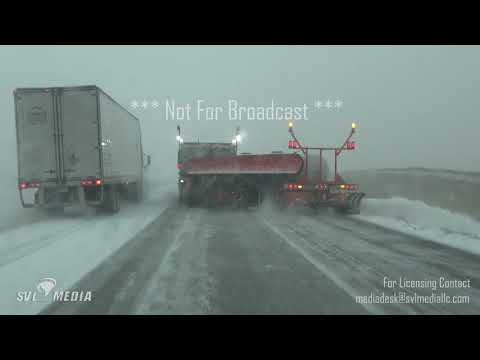
snowstorm delays hundreds of flights, shuts down highways in central US
snowstorm delays hundreds of flights, shuts down highways in central US


Veel te koud momenteel in noord Amerika.


quote:As AccuWeather predicted, the storm evolved into an “all-out blizzard” over the northern Plains on Friday. It’s the second snowstorm in less than two weeks to hit the northern U.S.
On Tuesday, Spokane, Washington, received a record-breaking 3.3 inches of snow. It was also the first measurable October snowfall there in 18 years. The weight of the snow on trees brought down limbs and entire trees, in some cases. The storm wiped out power to 30,000 customers in Spokane on Wednesday as the worst of the storm started shifting east over to Montana.


Denver afgelopen zaterdag : vol zon; 21 graden en cijfer 9
Zondag een dag later: sneeuw; -/-1 en cijfer 4
Zondag een dag later: sneeuw; -/-1 en cijfer 4
Kan snel gaan in de VS.quote:Op maandag 28 oktober 2019 22:40 schreef BeamofLight het volgende:
Denver afgelopen zaterdag : vol zon; 21 graden en cijfer 9
Zondag een dag later: sneeuw; -/-1 en cijfer 4
Kou is voorlopig nog wel even aanwezig en zakt zelfs nog wat verder naar het zuiden.
Jazeker.
Zeer koude november in delen van de Verenigde Staten
November verloopt buitengewoon koud in een groot deel van de Verenigde Staten. De weerdienst van de metropool Chicago berichtte dat het sinds het begin van de metingen in 1871 niet eerder is voorgekomen dat het tijdvak 1-15 november zo koud is geweest. De gemiddelde temperatuur bedroeg -0,4º, het vorige record (daterend uit 1991) was -0,3º. Ondertussen beleefde Anchorage in Alaska de zachtste eerste helft van november. Het gemiddelde kwam daar uit op 2,9 tegen 2,7º in 1979. De reeks van Anchorage loopt vanaf 1952.
http://m.janvissersweer.n(...)redirected=true#2743
Jazeker.
De link werkt niet....quote:Op zondag 17 november 2019 11:04 schreef 12Beaufort het volgende:
http://m.janvissersweer.n(...)redirected=true#2743
Ik kan het je wel uitleggen maar het niet voor je begrijpen........

94257 - 478969
In my dreams I'm dying all the time
In my dreams I'm dying all the time
quote:Op zondag 17 november 2019 21:57 schreef InverHouse het volgende:
[..]
https://janvissersweer.nl(...)redirected=true#2743
Ik kan het je wel uitleggen maar het niet voor je begrijpen........
Veel sneeuw in de VS voor en tijdens Thanksgiving. Vanaf dinsdag gaat het op grote schaal sneeuwen. Ook het noorden van Texas zal de nodige sneeuw krijgen (mogelijk meer dan 30 cm). Rond de grote meren (lake effect) en het noordoosten van de VS kan dit oplopen tot boven de 40 cm.
quote:A storm streaking across the center of the country could cause major delays for those traveling ahead of Thanksgiving.
The timing of the storm coincides with the peak of travel ahead of the Thanksgiving holiday. According to the American Automobile Association (AAA), the daily number of travelers will increase throughout the holiday week until Wednesday.
After bringing cold and snow to parts of the Northwest for the start of the week, a storm will gather in the center of the country on Tuesday. Intensification will allow the storm to bring snow, as well as gusty winds from Colorado and Wyoming, to Michigan and Wisconsin, through Wednesday.

94257 - 478969
In my dreams I'm dying all the time
In my dreams I'm dying all the time
Ook Noord Arizona (Flagstaff) gaat eind deze week bedolven worden onder een halve meter sneeuw.
“Rather than love, than money, than fame, give me truth.”
quote:Major snow and cold threaten parts of Atlantic Canada as Colorado low takes unusual path
A significant Colorado low is set to head towards Atlantic Canada early Thursday, November 28, 2019, which is expected to bring snow to spots that have not seen it this fall. Northwest winds behind the system will also blow brisk wind and onshore snow for the weekend, November 30 to December 1.
The low will have a much "wintrier" look than what has been seen so far this season, according to meteorologists from The Weather Network.
Most storms this season the region has seen so far this year have moved up the coast from the US and were bringing more rain and snow across the Maritimes and Newfoundland.
However, the next storm is taking an unusual track, cutting south from northern Ontario to cut across the Maritimes west to east.
"That's likely to allow cold air and a much more wintry taste to intrude further south," TWN meteorologists said.
"An initial push of rain is expected Wednesday night across Nova Scotia and southern New Brunswick before transitioning to heavy snow for much of New Brunswick on Thursday with some mixing inland for areas of southern Nova Scotia."
The heaviest snow is expected to fall on the northern areas of the Bay of Fundy. Portions of Nova Scotia could also see at least some accumulation of wet snow through Thursday.
Between 50 to 100 mm (2 to 4 inches) of snow is expected mainly inland and over higher lands.
Kan tot 90 cm gaan vallen. Dit gaat echt voor overlast zorgen in de VS. In het noorden vooral sneew en storm, meer naar het zuiden natte sneeuw en ijsregen.
quote:A troublesome combination of heavy rain, ice, snow and strong winds will hamper travelers making their way home from their Thanksgiving destinations this weekend as a large storm slowly navigates its way across the central United States.
As if a storm at the start of the busy Thanksgiving travel period was not enough, the second major storm this week will add to travel stress on the roads and at the airports.
A swath of heavy snow is forecast to extend from the Rockies in New Mexico and Colorado to the Plains of the Dakotas to areas surrounding Lake Superior in Minnesota, Wisconsin and Michigan.

94257 - 478969
In my dreams I'm dying all the time
In my dreams I'm dying all the time


‘Winterstorm’ legt leven noordoosten VS plat
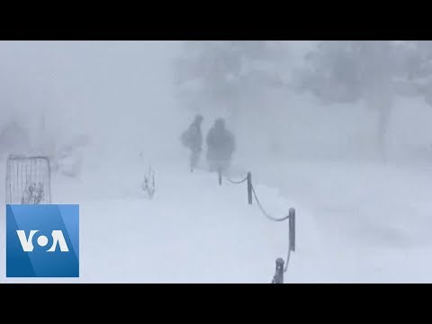
Sneeuw. Natte sneeuw. IJzel. Aanvriezende regen. IJsregen. Alle verschillende soorten winterse neerslag zijn al voorbij gekomen door een winterstorm. Niet verwonderlijk dat deze storm dan ook het leven plaatselijk in het noordoosten van de VS heeft platgelegd. En de ‘storm’ houdt nog tot en met maandag aan…
Met het ‘kleurrijke’ palet aan soorten winterse neerslag waarmee de blog begon weet je al snel dat het mis is. Ook voor mij, student op Cornell University in Ithaca in het noordoosten van de VS, is het een ‘kleurrijke’ winterse ervaring. Eentje die toch wel heel anders is van een ‘normale’ sneeuwdump…
Omlijst met een laagje ijs
Ten tijde van schrijven is het eerste deel van de ‘winterstorm’ voorbij. Tot nu toe is dit voor mij wel een van de meest bijzondere ‘weerservaringen’ die ik tot dus ver heb meegemaakt. In de afgelopen uren kwam het hele palet aan winterse neerslag voorbij. Van sneeuw tot ijzel, en van ijsregen (kleine korreltjes ijs) tot gewone regen. Het resultaat: spekgladde straten, en verlaten wegen. Veel voorwerpen werden ook bedekt met een laagje ijs, bijzonder om te zien.
rest van verhaal
94257 - 478969
In my dreams I'm dying all the time
In my dreams I'm dying all the time
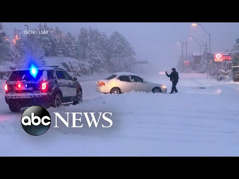
quote:Major winter storm affecting the United States on a busy holiday weekend, ice storm warnings in effect
A major winter storm that hammered the western United States and northern Plains with heavy snow and strong winds over the past couple of days has now reached the Great Lakes region. In South Dakota, 9 people were killed after a plane crashed due to severe weather on November 30, 2019. In Arizona, two children died while another is still missing after floods carried them away on November 29. Heavy rain and snow hit parts of California, leaving more than 17 000 without power.
This multi-faceted, trans-continental storm is producing a variety of impactful weather conditions on a busy Thanksgiving holiday travel weekend, ranging from blizzard conditions over parts of the Upper Midwest to strong thunderstorms across the Southeast U.S., NWS forecaster David Hamrick noted early Sunday, December 1.
Heavy snow can be expected from the eastern Dakotas to northern Michigan on Sunday, with potential snowfall accumulations on the order of 15 - 30 cm (6 to 12 inches).
"By late Sunday, secondary cyclogenesis occurs off the southern New England coast and becomes the dominant low pressure center through early in the week," Hamrick said.
"This will evolve into more of a typical nor'easter type system with rain and wind near the coast, and heavy snow inland. The potential exists for 20 to 40 cm (8 to 16 inches) of snow across interior portions of New York and extending eastward to southern Maine, with winter storm warnings in effect.
"Farther to the south across the central Appalachians, freezing rain will be more of a problem with the potential of up to 6 mm (0.25 inches) of ice accretion from extreme western Maryland to central Pennsylvania where ice storm warnings are in effect. Severe travel disruptions are likely for many of these areas."
Nine fatalities were reported after an Idaho-bound Pilatus PC-12 crashed shortly after takeoff in South Dakota on Saturday afternoon. Among those killed were the pilot and two children, according to the state's attorney for Brule County Theresa Maule Rossow. Meanwhile, three survivors were sent to a medical facility in Sioux Falls.
The cause of the crash has not yet been determined, but Maule Rossow said the weather conditions included "strong winds and snow" during the time of the crash. FAA investigators have traveled to the site. The National Transportation Safety Board will also manage the investigation.
Many parts of Arizona were hit with strong winds and floods across the Thanksgiving holiday week. On Friday morning, three children went missing after floodwater swept their vehicle. On Saturday, the Gila County Sheriff's Office said two of the victims have been found dead, while the search continues for the third missing child.
Several agencies including the Tonto Basin, TriCity, and Global Fire Departments lend their helping hand in the search.
The sheriff's office warned residents that some roads and bridges were closed due to unsafe conditions.
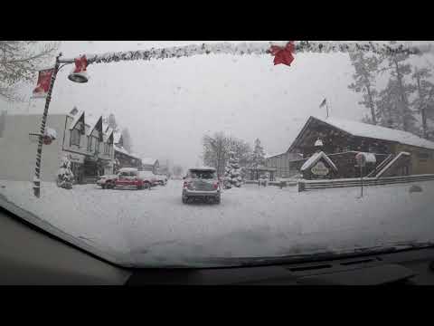
An atmospheric river brought record rainfall to parts of Los Angeles, California, and heavy snow to state's mountains and high deserts over the past couple of days.
Around 1 200 mm (47 inches) of snow was recorded at the Big Bear Mountain Resort on its opening day, November 29. "This is pretty unreal, especially for Southern California," said Justin Kanton, Big Bear Mountain Resort spokesman.

Vraag me af hoe ze dat doen met mensen die bijvoorbeeld een dag daarvoor zijn afgedaald naar Phantom Ranch. Met een beetje pech zit je dan gewoon enkele dagen vast op de bodem van GC en de bevoorrading zal dan ook niet heel soepeltjes verlopen (geen mogelijkheid om met ezels naar beneden te gaan)..quote:
“Rather than love, than money, than fame, give me truth.”
|
|