WKN Weer, Klimaat en Natuurrampen
Lees alles over het onstuimige weer op onze planeet, volg orkanen en tornado's, zie hoe vulkanen uitbarsten en hoe Moeder Aarde beeft bij een aardbeving. Alles over de verwoestende kracht van onze planeet en tal van andere natuurverschijnselen.


quote:Op zondag 12 april 2020 23:02 schreef Frutsel het volgende:
Volgens mij gaat Bassfield stuktwitter:TrustedWeather twitterde op zondag 12-04-2020 om 23:02:27 ANYONE LIVING IN BASSFIELD OR IN THE DIRECT PATH OF THIS EXTREMELY DANGEROUS TORNADO SHOULD TAKE SHELTER! THIS IS A TORNADO EMERGENCY! #tornado #emergency #mswx reageer retweet
 ANYONE LIVING IN BASSFIELD OR IN THE DIRECT PATH OF THIS EXTREMELY DANGEROUS TORNADO SHOULD TAKE SHELTER! THIS IS A TORNADO EMERGENCY!
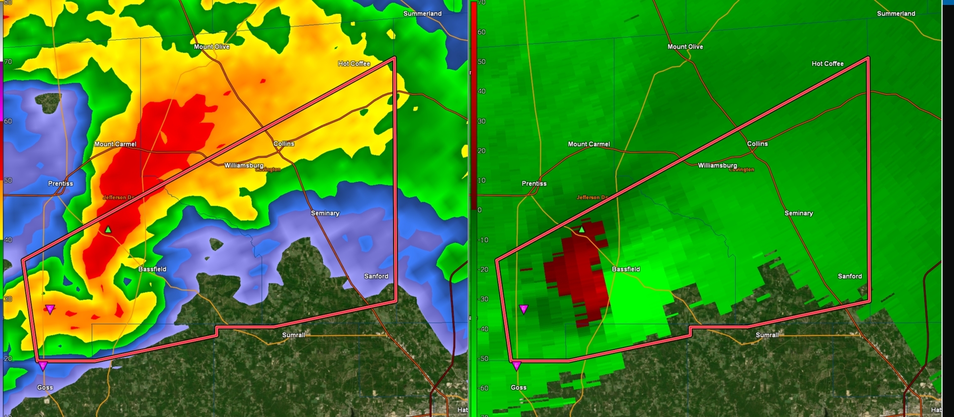


twitter:DHartman_WAPT twitterde op zondag 12-04-2020 om 23:17:31 On air but one of the worst tornado signatures I've seen in 35 years. CONCERNED https://t.co/VyHXlct0WL reageer retweet
 On air but one of the worst tornado signatures I've seen in 35 years. CONCERNED


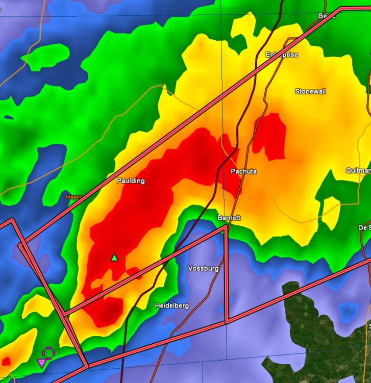
"Donut Hole" noemen ze dat op de TV in Mississippi... "You don't wanna see that, that is really bad"twitter:MatthewCappucci twitterde op zondag 12-04-2020 om 23:18:29 This is a horrific signature for Bassfield, #Mississippi. The town center - home to more than 300 people - appears engulfed by the storm's Bounded Weak Echo Region. ?
That's where the tornado's updraft is so strong that rain doesn't fall, leaving a doughnut-hole void. #tornado https://t.co/8MmAcuTLgg reageer retweet
 This is a horrific signature for Bassfield,
twitter:Breaking_4_News twitterde op zondag 12-04-2020 om 23:32:49 #BREAKING: Major Tornado Emergency Declared In Southern Mississippi. Reports Of catastrophic Damage In The City Of #Bassfield. #BreakingNews reageer retweet

Ja ik zag het..quote:
 Op
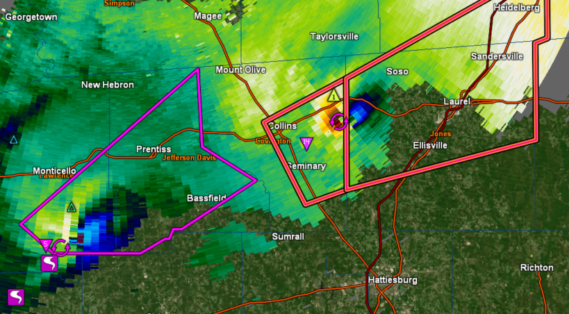
Op Dezelfde Bassfield tornado gaat nu richting Laurel... stad van 20.000 inwoners

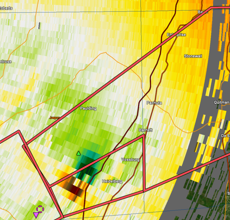
(TDS = Tornado Debris Signature)twitter:ou_sams twitterde op zondag 12-04-2020 om 23:40:28 This is simply incredible. The TDS from the Bassville, MS extended up to at least 28,000 feet, and had a peak Vrot of at *least* 110 kt, placing it in an elite tier of violent tornadoes, potentially among the likes of El Reno 2011 and Vilonia 2014. https://t.co/4BcLROr5tV reageer retweet
 This is simply incredible. The TDS from the Bassville, MS extended up to at least 28,000 feet, and had a peak Vrot of at *least* 110 kt, placing it in an elite tier of violent tornadoes, potentially among the likes of El Reno 2011 and Vilonia 2014.
 https://en.wikipedia.org/wiki/Tornado_debris_signature
twitter:ReedTimmerAccu twitterde op zondag 12-04-2020 om 23:43:19 EF4 to EF5 TORNADO is heading for Laurel, MS! Take shelter immediately @RadarOmega_WX https://t.co/HsH7lrcUJh reageer retweet
 EF4 to EF5 TORNADO is heading for Laurel, MS! Take shelter immediately @
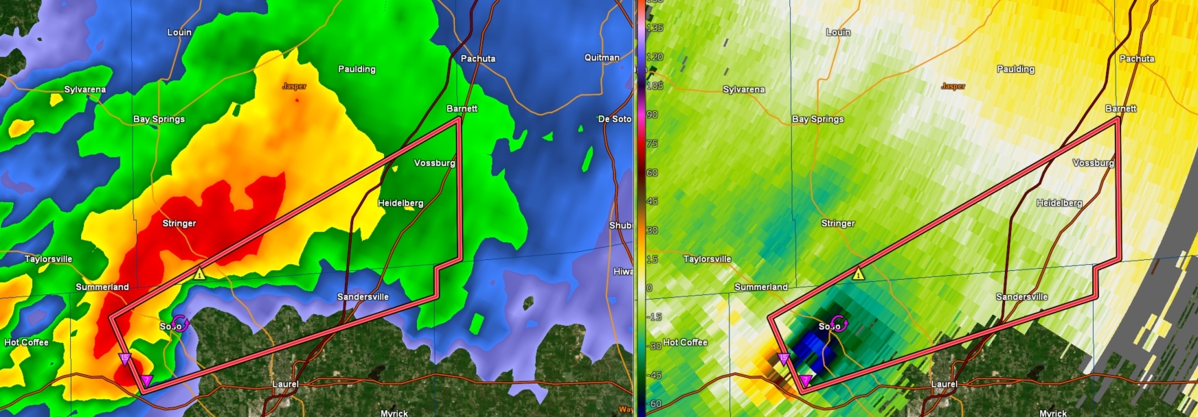

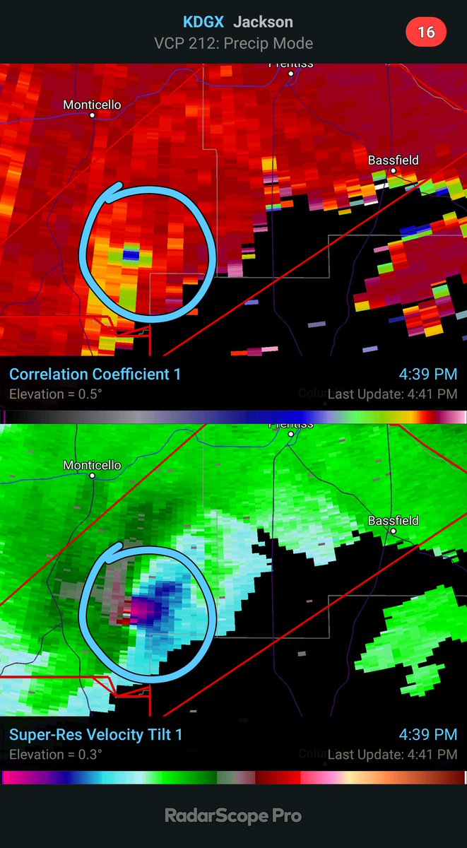
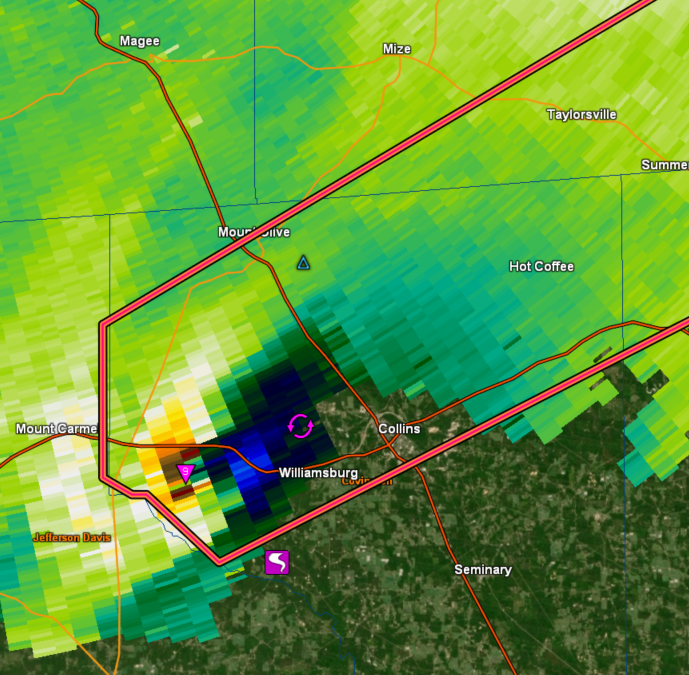
twitter:Sean_Ernst_Wx twitterde op zondag 12-04-2020 om 23:45:50 Horrifying signature of the most violent of tornadoes - debris picked up by the tornado thrown into the updraft and sent into the forward flank of the storm. Only the strongest updrafts can manage this. https://t.co/mmKRAdlwaj reageer retweet
 Horrifying signature of the most violent of tornadoes - debris picked up by the tornado thrown into the updraft and sent into the forward flank of the storm. Only the strongest updrafts can manage this.
Fokking hell... dat ding blijft maar doorgaanquote:
[ afbeelding ]
Laurel is gespaard maar vol over Soso heen.
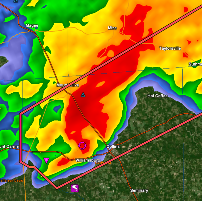
twitter:ConnorWX twitterde op zondag 12-04-2020 om 23:57:19 Huge, destructive tornado in Soso, MS just now @WXgage https://t.co/zpzuEa5erS reageer retweet
 Huge, destructive tornado in Soso, MS just now @
quote:[ afbeelding ]twitter:ConnorWX twitterde op zondag 12-04-2020 om 23:57:19 Huge, destructive tornado in Soso, MS just now @:WXgage https://t.co/zpzuEa5erS reageer retweet
Echt groot dezequote:[ afbeelding ]twitter:ConnorWX twitterde op zondag 12-04-2020 om 23:57:19 Huge, destructive tornado in Soso, MS just now @:WXgage https://t.co/zpzuEa5erS reageer retweet
Teringquote:[ afbeelding ]twitter:ConnorWX twitterde op zondag 12-04-2020 om 23:57:19 Huge, destructive tornado in Soso, MS just now @:WXgage https://t.co/zpzuEa5erS reageer retweet
Recht zo die gaat, braaf zo die heen.
Tornado warning voor de eerste is ingetrokkenquote:
Dat ding is dus nu al 90 minuten aan de grond?
Dus nu is het afwachten op de eerste meldingen en foto's uit Bassfield en Soso?quote:
[..]
Tornado warning voor de eerste is ingetrokken
Ik snap al die radarbeelden bij tornado's niet 
Het grootste deel is hevige regen en dan een klein deel en dat is de tornado?
Het grootste deel is hevige regen en dan een klein deel en dat is de tornado?
twitter:MSEMA twitterde op maandag 13-04-2020 om 02:00:38 UPDATE: Three confirmed fatalities in Jefferson Davis County reageer retweet
 UPDATE: Three confirmed fatalities in Jefferson Davis County
Ligt eraan op welk plaatje je kijkt. Meestal zie je de wolkenformatie en dat heeft een bepaald patroon waarbij bijv aan de onderkant van de radarformatie een "haak" te zien is wat kan duiden op een tornado.quote:Op maandag 13 april 2020 00:58 schreef heywoodu het volgende:
Ik snap al die radarbeelden bij tornado's niet
Het grootste deel is hevige regen en dan een klein deel en dat is de tornado?
https://www.nssl.noaa.gov/education/svrwx101/tornadoes/detection/
twitter:WeatherScottT twitterde op maandag 13-04-2020 om 02:12:33 #BREAKING: At least 6 people have been killed by severe storms in Mississippi today. 3 in Jefferson Davis County; 2 in Lawrence County; 1 in Walthall County. #mswx #weather #Severe #storms reageer retweet

One person suggested it was the most destructive tornado since Joplin,quote:Mississippi hit with two ‘catastrophic’ EF5 tornadoes at the same time: ‘This is flattening everything in its path’
The southeastern United States is being pummeled with tornadoes, but the largest storm, an EF5 tornado, has already killed at least six people in Mississippi.
One person suggested it was the most destructive tornado since Joplin, Missouri in 2011, but Oklahoma had two EF5 tornadoes after that in May 2011 in El Reno and May 2013 in Moore/Newcastle.
Meteorologist Alex Lamers tweeted, “I don’t recall ever seeing two such massive debris fallout signatures in close proximity before. Any radar experts remember one?”
The concern was that there may have been two EF5 tornadoes because there were two debris balls being observed on radar. Meteorologists, climatologists and weather experts all concluded it was like nothing they’ve ever seen before.
Misschien nog wel groter dan Joplin...
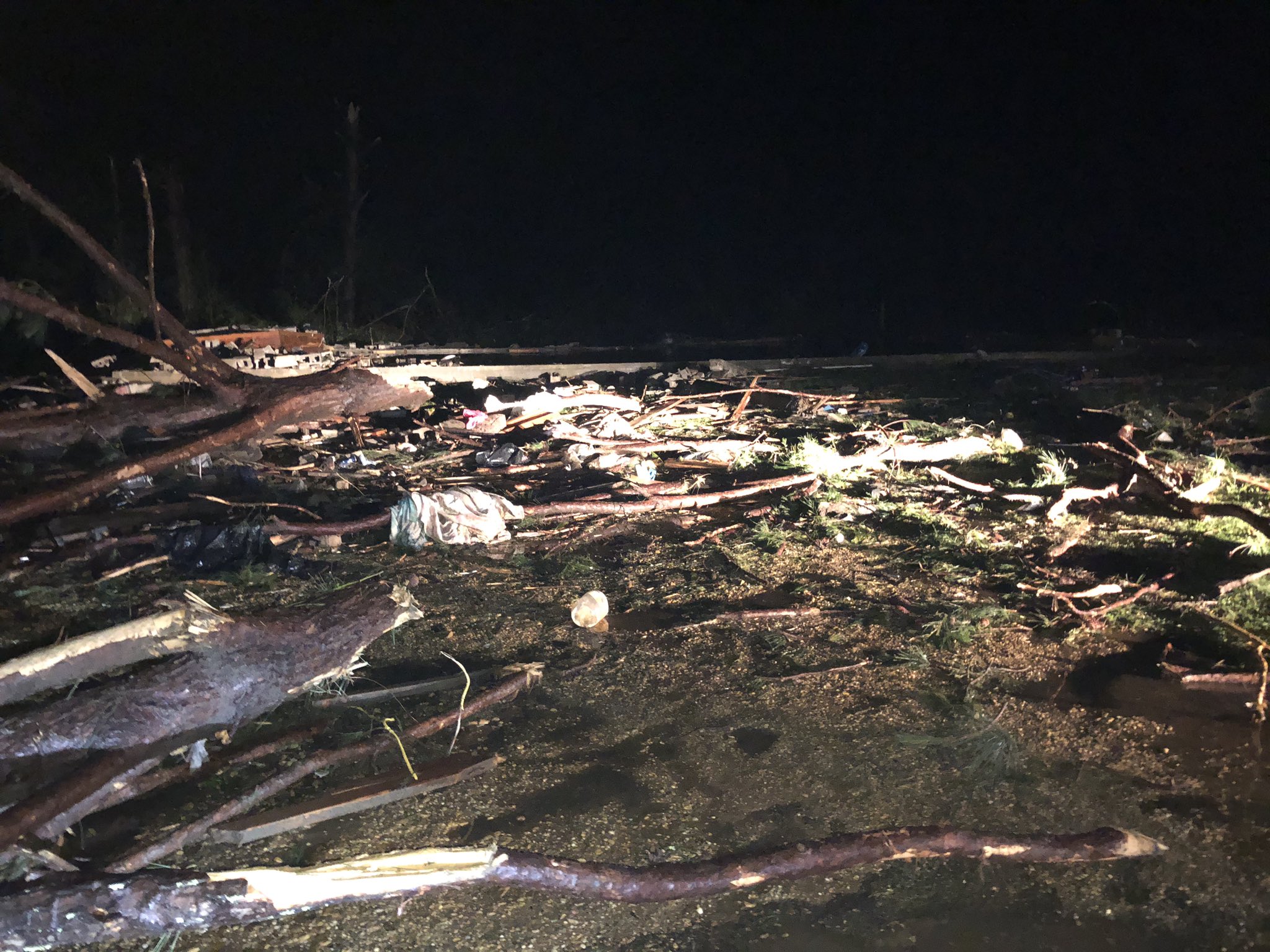
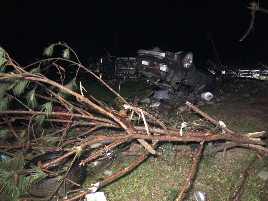
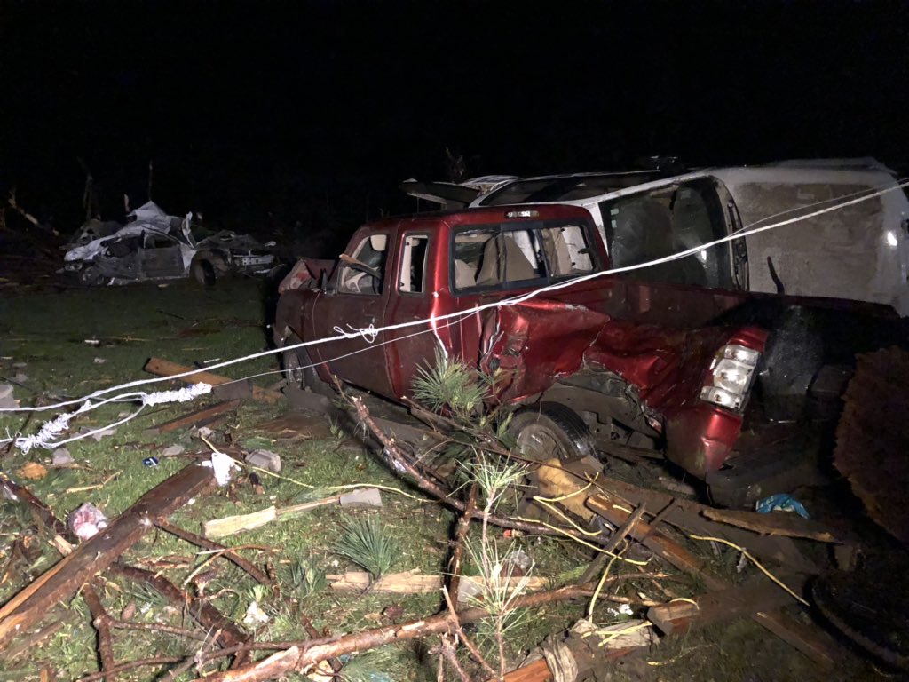
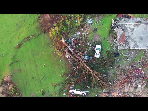
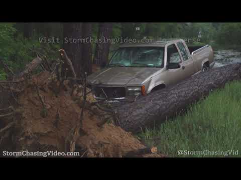
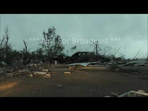
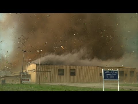
twitter:crabblers twitterde op maandag 13-04-2020 om 04:00:09 Utter devastation: Cars flipped over, a building slabbed. Folks say 2 of the 3 deceased in Bassfield died right here. https://t.co/XavAJgmQIs reageer retweet
 Utter devastation: Cars flipped over, a building slabbed. Folks say 2 of the 3 deceased in Bassfield died right here.
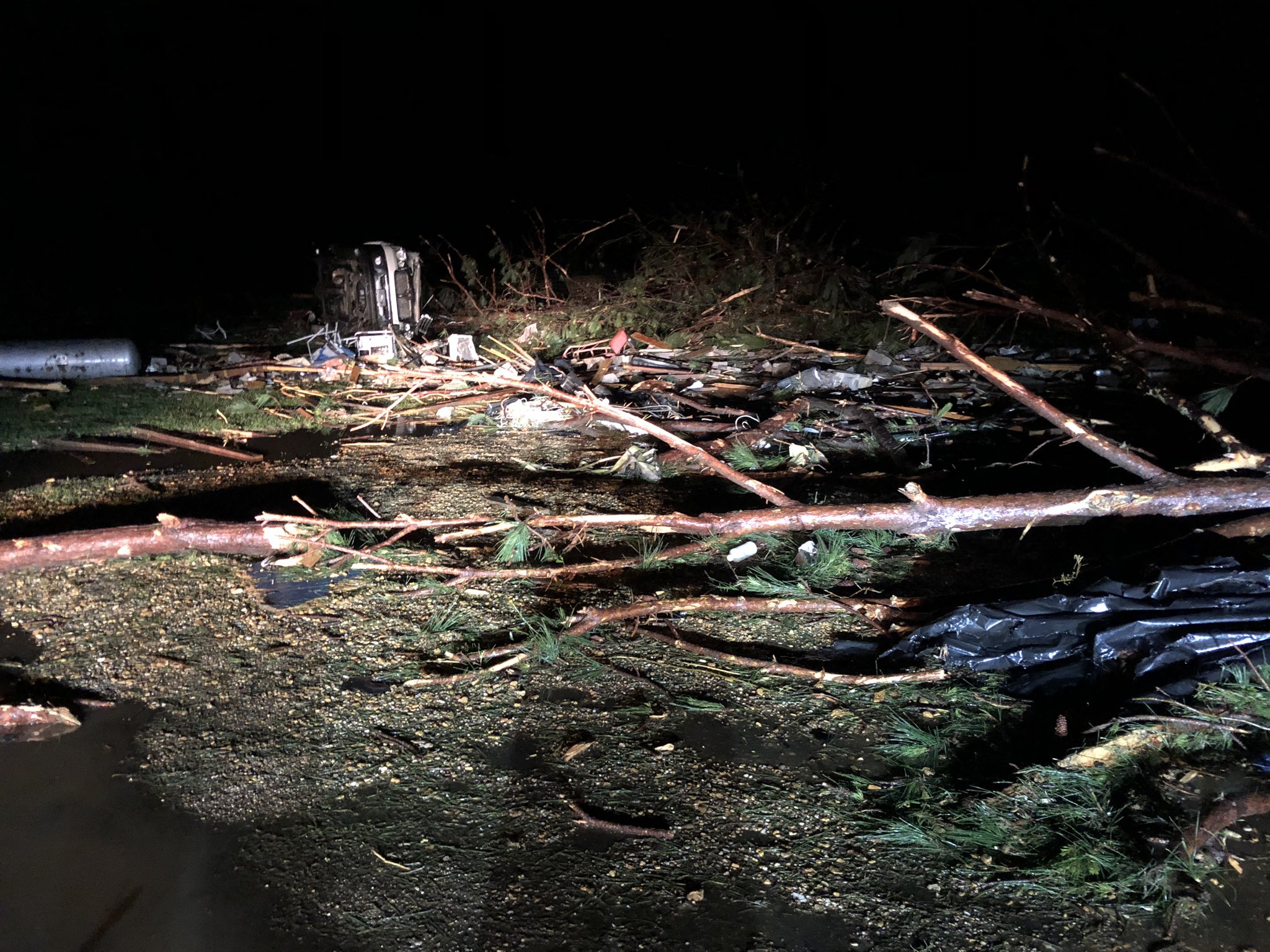
[ Bericht 14% gewijzigd door Houtenbeen op 13-04-2020 04:22:38 ]
Even op daglicht drone foto's wachten. Ben benieuwd naar het verwoestend pad wat deze tornado aangericht heeft.
Nog steeds veel buien actief
Never Stop Exploring!
Life begins at the end of your comfort zone!
Follow me on Twitter: https://twitter.com/EdwinKr83 Instagram: https://www.instagram.com/edwinkr83/
Life begins at the end of your comfort zone!
Follow me on Twitter: https://twitter.com/EdwinKr83 Instagram: https://www.instagram.com/edwinkr83/
Ik zat gisterenavond nog op mijn gemak beelden terug te kijken van o.a. de Joplin, Tuscaloosa en El Reno/Oklahoma City tornado's. Zeer indrukwekkend allemaal. Totaal gemist dat later op de avond dit aan de gang was.
In de Verenigde Staten is een tornado door de zuidelijke staten Arkansas, Mississippi en Louisiana getrokken. Mississippi werd het zwaarst getroffen. Daar zijn zes mensen omgekomen toen de tornado hun woningen optilde terwijl de bewoners nog binnen waren.
https://www.vrt.be/vrtnws(...)pi-corona-bemoeilij/
https://www.vrt.be/vrtnws(...)pi-corona-bemoeilij/
Opgelopen naar 8 doden.
At least eight people are dead as severe weather and strong tornadoes moved across the South on Easter Sunday and into Monday, destroying homes and businesses and leaving hundreds of thousands without power.
There were at least 39 reports of tornadoes as the storms slashed a deadly and destructive path across several states.
https://www.wunderground.(...)uth?cm_ven=hp-slot-1
Wat een puinhoop
Ook echt heel erg in een heel klein gebied als ik alles zo lees.
Ook echt heel erg in een heel klein gebied als ik alles zo lees.
100.000 katjes
Fuck the EBU!
Fuck the EBU!
Paar dagen voor definitief antwoord. Maar als het zo daglicht is zal er een schatting komen.quote:
Hoe lang duurt het doorgaans voor men 'beslist' of het een EF4 of EF5 was?
Never Stop Exploring!
Life begins at the end of your comfort zone!
Follow me on Twitter: https://twitter.com/EdwinKr83 Instagram: https://www.instagram.com/edwinkr83/
Life begins at the end of your comfort zone!
Follow me on Twitter: https://twitter.com/EdwinKr83 Instagram: https://www.instagram.com/edwinkr83/

Die wedge tornado was een beste joekel

Never Stop Exploring!
Life begins at the end of your comfort zone!
Follow me on Twitter: https://twitter.com/EdwinKr83 Instagram: https://www.instagram.com/edwinkr83/
Life begins at the end of your comfort zone!
Follow me on Twitter: https://twitter.com/EdwinKr83 Instagram: https://www.instagram.com/edwinkr83/


quote:Dodental tornado stijgt tot boven de 30; schuilkelders toch open ondanks corona
In het zuiden van de Verenigde Staten zijn al ruim 30 mensen om het leven gekomen door het zware stormweer. Alleen al in Mississippi kwamen elf mensen om het leven na de doortocht van verschillende tornado’s. Ook South Carolina, Louisiana, Georgia en Arkansas zijn zwaar getroffen. Meer dan een miljoen huishoudens zit zonder stroom.
Weerdienst NOAA waarschuwde zondagmiddag voor tornado’s met windstoten tot 330 kilometer per uur. De weerdienst sprak van een ‘uitzonderlijk zeldzame gebeurtenis’. Beelden op sociale media lieten zien hoe de tornado's een spoor van vernieling hebben achtergelaten.
In South Carolina kwamen volgens televisiezender ABC zeker negen mensen om in erg hevig stormweer, in Georgia vielen acht doden, in Tennessee drie en in Arkansas één. Ook de staat Louisiana werd zwaar getroffen. Honderden huizen werden daar vernield.
Schuilen
Door de coronacrisis twijfelden diverse lokale autoriteiten of ze de openbare schuilkelders wel moesten openen voor de inwoners. In Alexander City zei burgemeester Thomas Spraggins aanvankelijk dat de deuren gesloten zouden blijven en mensen zelf een veilig heenkomen moesten zoeken. Maar uiteindelijk besloot hij toch mensen met mondkapjes en handschoenen toe te laten nadat hun temperatuur was gecheckt. In de staat Mississippi werden mensen opgeroepen om ook op de schuilplekken 2 meter afstand te bewaren.
In dit geval kwam 'debris' 200 kilometer verderop...twitter:spann twitterde op dinsdag 14-04-2020 om 13:26:31 This picture has been identified. It was lofted by an EF-4 at Moss, Mississippi. Traveled 121 miles to Tuscaloosa County Alabama. One of those that lived in the home is in critical condition. https://t.co/ZFneQzQfuU reageer retweet
 This picture has been identified. It was lofted by an EF-4 at Moss, Mississippi. Traveled 121 miles to Tuscaloosa County Alabama. One of those that lived in the home is in critical condition.
32 doden momenteel volgens dit stuk
https://weather.com/storm(...)mississippi-arkansas
Monroe Tornado is een EF3
Tot nu toe is de Bassfield / Soso tornado geclassificeerd als EF4 maar wordt nog onderzocht of het een EF5 was.
https://en.wikipedia.org/wiki/2020_Easter_tornado_outbreak
https://weather.com/storm(...)mississippi-arkansas
Monroe Tornado is een EF3
Tot nu toe is de Bassfield / Soso tornado geclassificeerd als EF4 maar wordt nog onderzocht of het een EF5 was.
https://en.wikipedia.org/wiki/2020_Easter_tornado_outbreak


Die wedge tornado is echt huge
Never Stop Exploring!
Life begins at the end of your comfort zone!
Follow me on Twitter: https://twitter.com/EdwinKr83 Instagram: https://www.instagram.com/edwinkr83/
Life begins at the end of your comfort zone!
Follow me on Twitter: https://twitter.com/EdwinKr83 Instagram: https://www.instagram.com/edwinkr83/
Ruim 3 kilometer breed...twitter:NWSJacksonMS twitterde op donderdag 16-04-2020 om 04:07:40 The Easter EF4 tornado that began in Jefferson Davis Co. and tracked for ~68 miles before lifting in Clarke Co. was at least 2 miles wide. This will be the widest tornado in Mississippi history, surpassing the April 24, 2010 tornado that tracked through Yazoo City (1.75 miles). reageer retweet
 The Easter EF4 tornado that began in Jefferson Davis Co. and tracked for ~68 miles before lifting in Clarke Co. was at least 2 miles wide. This will be the widest tornado in Mississippi history, surpassing the April 24, 2010 tornado that tracked through Yazoo City (1.75 miles).
Een tornado die 3 km breed is, wtf. dat is wel hugequote:Ruim 3 kilometer breed...twitter:NWSJacksonMS twitterde op donderdag 16-04-2020 om 04:07:40 The Easter EF4 tornado that began in Jefferson Davis Co. and tracked for ~68 miles before lifting in Clarke Co. was at least 2 miles wide. This will be the widest tornado in Mississippi history, surpassing the April 24, 2010 tornado that tracked through Yazoo City (1.75 miles). reageer retweet
Never Stop Exploring!
Life begins at the end of your comfort zone!
Follow me on Twitter: https://twitter.com/EdwinKr83 Instagram: https://www.instagram.com/edwinkr83/
Life begins at the end of your comfort zone!
Follow me on Twitter: https://twitter.com/EdwinKr83 Instagram: https://www.instagram.com/edwinkr83/
Zeven doden bij die tornado is wel opvallend laag, wat een monsterquote:Ruim 3 kilometer breed...twitter:NWSJacksonMS twitterde op donderdag 16-04-2020 om 04:07:40 The Easter EF4 tornado that began in Jefferson Davis Co. and tracked for ~68 miles before lifting in Clarke Co. was at least 2 miles wide. This will be the widest tornado in Mississippi history, surpassing the April 24, 2010 tornado that tracked through Yazoo City (1.75 miles). reageer retweet


Afgelopen zondag dus ook een EF4 in Mississippi geweest
Aan het pad te zien is dat ook de tornado van Purvis geweest.
Slechts 1 dode tot nu toe op zondag
https://eu.clarionledger.(...)-updates/5154914002/
Aan het pad te zien is dat ook de tornado van Purvis geweest.

Slechts 1 dode tot nu toe op zondag
https://eu.clarionledger.(...)-updates/5154914002/
twitter:CharlesPeekWX twitterde op donderdag 23-04-2020 om 00:05:24 Tornado just went through Madill, OK. @weatherchannel @nwsnorman https://t.co/35qPGXqu3z reageer retweet
 Tornado just went through Madill, OK. @
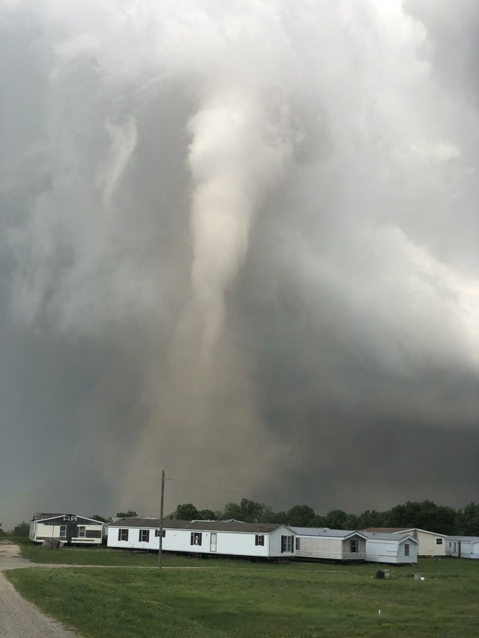
twitter:MikeyGribble twitterde op donderdag 23-04-2020 om 00:00:38 Tornado in Madill, OK. May have just clipped south side of town. Fairly weak but saw some debris lifted https://t.co/5K736sD6mN reageer retweet
 Tornado in Madill, OK. May have just clipped south side of town. Fairly weak but saw some debris lifted
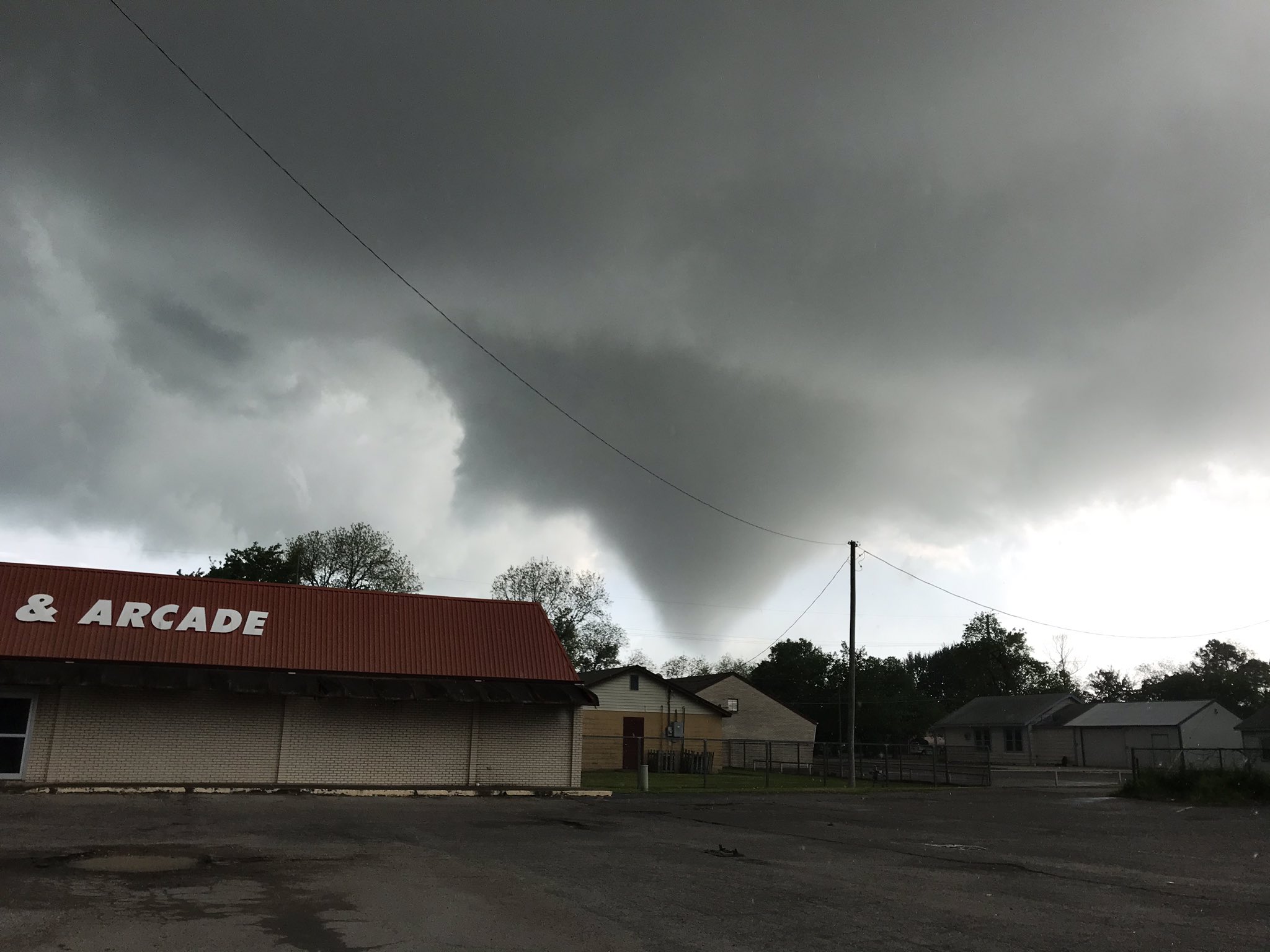


vandaag en morgen Enhanced Risk
Spel is al op de wagen
twitter:MJVentrice twitterde op donderdag 23-04-2020 om 00:29:40 Wow... Four discret supercells all tornado warned in Oklahoma. https://t.co/vmatDchPfj reageer retweet
 Wow... Four discret supercells all tornado warned in Oklahoma.
Zou in elk geval één dode zijn in Madillquote:[ afbeelding ]twitter:CharlesPeekWX twitterde op donderdag 23-04-2020 om 00:05:24 Tornado just went through Madill, OK. @:weatherchannel @:nwsnorman https://t.co/35qPGXqu3z reageer retweet[ afbeelding ]twitter:MikeyGribble twitterde op donderdag 23-04-2020 om 00:00:38 Tornado in Madill, OK. May have just clipped south side of town. Fairly weak but saw some debris lifted https://t.co/5K736sD6mN reageer retweet

Je moet het ook maar durven filmen...boh. wel vet
Never Stop Exploring!
Life begins at the end of your comfort zone!
Follow me on Twitter: https://twitter.com/EdwinKr83 Instagram: https://www.instagram.com/edwinkr83/
Life begins at the end of your comfort zone!
Follow me on Twitter: https://twitter.com/EdwinKr83 Instagram: https://www.instagram.com/edwinkr83/

Gaan ze weer...en nog een aantal keer deze week.quote:
[ afbeelding ]
Enhanced Risk weer voor 28/4 tot 29/4
April 27, 2011: Nine Years Later
Never Stop Exploring!
Life begins at the end of your comfort zone!
Follow me on Twitter: https://twitter.com/EdwinKr83 Instagram: https://www.instagram.com/edwinkr83/
Life begins at the end of your comfort zone!
Follow me on Twitter: https://twitter.com/EdwinKr83 Instagram: https://www.instagram.com/edwinkr83/
Ruim 200 tornado's op de 27e waarvan 4x EF5quote:
[..]
Gaan ze weer...en nog een aantal keer deze week.
April 27, 2011: Nine Years Later

362 op 1 dag. Dat is echt veelquote:
[..]
Ruim 200 tornado's op de 27e waarvan 4x EF5
Never Stop Exploring!
Life begins at the end of your comfort zone!
Follow me on Twitter: https://twitter.com/EdwinKr83 Instagram: https://www.instagram.com/edwinkr83/
Life begins at the end of your comfort zone!
Follow me on Twitter: https://twitter.com/EdwinKr83 Instagram: https://www.instagram.com/edwinkr83/
Nee dat waren er 362 in die hele outbreak (25-27 april)quote:
https://en.wikipedia.org/wiki/2011_Super_Outbreak
Dan las ik verkeerd, maar ik vind 200 op 1 dag nog steeds buitengewoon veel.quote:
[..]
Nee dat waren er 362 in die hele outbreak (25-27 april)
https://en.wikipedia.org/wiki/2011_Super_Outbreak
Ook die van eind mei werd benoemd. Als ik al eens een tornado laat zien en de schade e.d, dan is dat vaak die EF5 die Joplin trof. Wat was dat een monster apparaat.
En ze moeten de hele maand mei nog
Never Stop Exploring!
Life begins at the end of your comfort zone!
Follow me on Twitter: https://twitter.com/EdwinKr83 Instagram: https://www.instagram.com/edwinkr83/
Life begins at the end of your comfort zone!
Follow me on Twitter: https://twitter.com/EdwinKr83 Instagram: https://www.instagram.com/edwinkr83/
Inderdaad. Joplin of anders Moore, Greensburg Of El Renoquote:
[..]
Dan las ik verkeerd, maar ik vind 200 op 1 dag nog steeds buitengewoon veel.
Ook die van eind mei werd benoemd. Als ik al eens een tornado laat zien en de schade e.d, dan is dat vaak die EF5 die Joplin trof. Wat was dat een monster apparaat.
En dan over in het voorspelde drukke orkaanseizoen...quote:En ze moeten de hele maand mei nog
In Miami zijn diverse temperatuurrecords gebroken afgelopen maand. Het zeewater ligt qua temperatuur al 2 graden boven gemiddeldquote:
[..]
Inderdaad. Joplin of anders Moore, Greensburg Of El Reno
[..]
En dan over in het voorspelde drukke orkaanseizoen...
Never Stop Exploring!
Life begins at the end of your comfort zone!
Follow me on Twitter: https://twitter.com/EdwinKr83 Instagram: https://www.instagram.com/edwinkr83/
Life begins at the end of your comfort zone!
Follow me on Twitter: https://twitter.com/EdwinKr83 Instagram: https://www.instagram.com/edwinkr83/

Tornado's en hagelstenen zo groot als honkbalballen houden huis in Texas: ‘Er komt nog meer aan’
https://www.ad.nl/buitenl(...)g-meer-aan~abacb290/
Sunne knoeperts.
https://www.ad.nl/buitenl(...)g-meer-aan~abacb290/
Sunne knoeperts.
"Honkbalballen"quote:
Tornado's en hagelstenen zo groot als honkbalballen houden huis in Texas: ‘Er komt nog meer aan’
https://www.ad.nl/buitenl(...)g-meer-aan~abacb290/
Sunne knoeperts.
Gebruiken ze bij voetbal ook een voetbalbal?
Werken bij het AD.nlquote:
[..]
"Honkbalballen"
Gebruiken ze bij voetbal ook een voetbalbal?

Volgens mij wel.quote:
[ afbeelding ]
Moderate Risk.. Detroit onder vuur
Zijn dit de rest van tropische storm Cristobal?
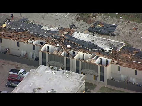
quote:Late-evening EF-2 tornado hits Arlington as the first significant November tornado in North Texas since 1987
A late-evening tornado touched down in Arlington, Dallas-Forth Worth Metropolitan Area on November 24, 2020, leaving a trail of damage to buildings and vehicles. The National Weather Service (NWS) said their survey team found EF-2 damage in south Arlington.
Just before 21:00 LT on November 24, a severe storm capable of producing a tornado was located near Grand Prairie, moving east at 72 km/h (45 miles per hour), according to LXAS news. The tornado warning was lifted just after 21:20 LT (03:20 UTC, November 25).
Shortly after, the Arlington Police Department said that it's assisting the Arlington Fire Department with damage across the city. "This also includes various roof collapses on some structures and damages to buildings. Working to determine extent of damages and whether or not there are any injuries."
"Pioneer Parkway is closed in both directions between Center Street and Collins Street due to debris from area apartment complexes on roadway."
NBC said it appears that one of the hardest-hit areas is just south of West Pioneer Parkway near South Cooper Street. The worst-hit were the Mirage and Waterdance Circle apartment complexes along Pioneer Parkway.
The NWS Forth Worth office said their survey team found EF-2 damage in south Arlington.
The maximum estimated winds were 185 km/h (115 mph), the survey found. The tornado had a path length of 8.1 km (5.04 miles) and maximum width of 137 m (150 yards).
It was on the ground for about 7 minutes, injuring 5 people and displacing 75 families.
The Arlington Fire Department said 3 apartment complexes collapsed, as well as 2 commercial buildings, a church, and a home. Gas leaks and downed power lines were also reported at various locations.


Ze zien een patroon met 2011. 2011, never forget:

Alleen in april al 700 stuks. Ik ben benieuwd. Die in Joplin was wel zo'n enorm beest, dat is niet te bevatten.
https://www.youtube.com/results?search_query=tornado+2011+joplin
Never Stop Exploring!
Life begins at the end of your comfort zone!
Follow me on Twitter: https://twitter.com/EdwinKr83 Instagram: https://www.instagram.com/edwinkr83/
Life begins at the end of your comfort zone!
Follow me on Twitter: https://twitter.com/EdwinKr83 Instagram: https://www.instagram.com/edwinkr83/
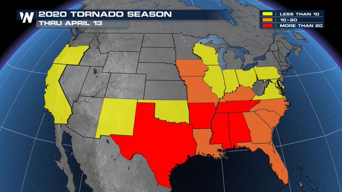
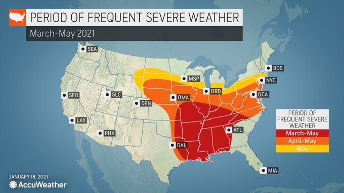
quote:This year's tornado season could be more severe than usual across the USA, in part because of La Niña.
The climate pattern called La Niña – a natural cycle marked by cooler-than-average ocean water in the central Pacific Ocean – is one of the main drivers of weather around the world, especially during the late fall, winter and early spring.
El Niño is the warming of these waters, which leads to different effects on weather patterns, according to Weather.com.
AccuWeather meteorologists said that because of La Niña, severe weather and tornado activity could abruptly fire up and rival 2011, one of the most notorious severe weather seasons, when tornadoes killed more than 550 Americans.
"The temperature of the water in the central and eastern tropical Pacific during February 2021 is similar to the La Niña pattern in February 2011," AccuWeather meteorologist Paul Pastelok said.
A study in 2015 from Columbia University found that a fairly strong La Niña brings more tornadoes and hailstorms over portions of Oklahoma, Texas, Kansas and other parts of the southern USA.
La Niña concentrates hot, humid air over the southern USA, the National Oceanic and Atmospheric Administration said. The heat and humidity over the southern Plains states sets up a strong north-south temperature gradient, which in turn favors storm formation.
A study in 2017 published by the American Meteorological Society also found a link between U.S. tornado activity and La Niña.
Based on past decades, the chance for tornadoes typically increases from February into March in the South, and it is highest from April through June across the Plains, Weather.com said.
Pastelok said the mid- to lower-Mississippi Valley and the mid-Atlantic regions will have the highest risk for severe weather this spring.
Though several private teams offer seasonal tornado forecasts, including AccuWeather and Weather.com, the federal government's NOAA does not, at least yet.
"Seasonal tornado forecasts are challenging, and there's some work being done on the problem," Harold Brooks, a senior research scientist at NOAA's National Severe Storms Laboratory, told USA TODAY.
"A big value of seasonal forecasts is that it provides a venue to highlight preparation and safety information to the public. That's the biggest thing about the hurricane forecasts and is a reason we might consider making them (tornado forecasts) in NOAA," he said.
Tornado activity is forecast to be slightly above normal for the year, and the number of tornadoes is expected to reach 1,350 to 1,500 in 2021 across the USA, according to AccuWeather meteorologists. Annually, the number of tornadoes averages 1,250 to 1,400, according to U.S. government statistics.
Already this year, there have been two deadly tornadoes, according to the Storm Prediction Center: one in central Alabama on Jan. 25, which killed one person and injured at least 30, and another in North Carolina on Feb. 15, in which three people died. The North Carolina twister, which left at least 10 people injured, hit southeastern Brunswick County near Grissettown.
Last year was a below-average year for tornadoes. According to preliminary figures, there were 1,075 reports in 2020, AccuWeather said.
The number and severity of tornadoes in any given year do not appear to be linked to human-caused climate change. A report in 2016 from the National Academy of Sciences, Engineering and Medicine found that of all weather phenomena, severe storms and tornadoes are the most difficult to attribute directly to climate change.
Komende dagen vooralsnog een slight risk voor delen van Tornado Alley.
Langzaam komt het daar op gang.
Volgens Reed mogelijk nog een opschaling voor zaterdag
Langzaam komt het daar op gang.
Volgens Reed mogelijk nog een opschaling voor zaterdag
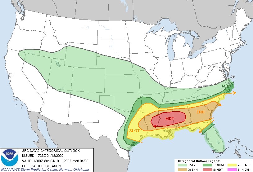
An Enhanced Risk of Severe Thunderstorms is Forecast Today and/or Tonight
Scattered severe thunderstorms are expected across the Oklahoma and Texas Panhandles, northwest Texas, and western Oklahoma on Saturday, with the greatest threat expected from mid afternoon into the early evening. A few tornadoes, some possibly strong, and very large hail will be the primary hazards, with damaging wind gusts possible as well.
Scattered severe thunderstorms are expected across the Oklahoma and Texas Panhandles, northwest Texas, and western Oklahoma on Saturday, with the greatest threat expected from mid afternoon into the early evening. A few tornadoes, some possibly strong, and very large hail will be the primary hazards, with damaging wind gusts possible as well.

Never Stop Exploring!
Life begins at the end of your comfort zone!
Follow me on Twitter: https://twitter.com/EdwinKr83 Instagram: https://www.instagram.com/edwinkr83/
Life begins at the end of your comfort zone!
Follow me on Twitter: https://twitter.com/EdwinKr83 Instagram: https://www.instagram.com/edwinkr83/

