WKN Weer, Klimaat en Natuurrampen
Lees alles over het onstuimige weer op onze planeet, volg orkanen en tornado's, zie hoe vulkanen uitbarsten en hoe Moeder Aarde beeft bij een aardbeving. Alles over de verwoestende kracht van onze planeet en tal van andere natuurverschijnselen.


Koop zo'n ding dan:quote:Op donderdag 9 augustus 2018 00:32 schreef Nattekat het volgende:
[..]
Jij denkt dat de slang door zo'n mooi gat in het kozijn gaat?


Ja CHAOS! Dag des doods voor Den Helder en de eilanden.
Overdreven waarschijnlijk, maar toch. wie weet
Overdreven waarschijnlijk, maar toch. wie weet
Opgeblazen gevoel of winderigheid? Zo opgelost met Rennie!
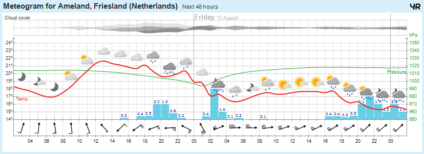
Mn slaapkamer is eindelijk 19 graden  Hopelijk kan ik eindelijk goed slapen en word ik niet wakker van het onweer
Ik kon gister niet slapen door onweer, regen en benauwdheid, was bij thuiskomst vanavond zo moe dat ik in slaap ben gedonderd en kan nu weer niet slapen omdat mijn ritme naar de tering is.
Topleven
Topleven
100.000 katjes
Fuck the EBU!
Fuck the EBU!
Die kampeerders op de Waddeneilanden zullen wel ergens op een booreiland voor de Engelse kust terecht komen.quote:Op donderdag 9 augustus 2018 00:42 schreef Eyjafjallajoekull het volgende:
Ja CHAOS! Dag des doods voor Den Helder en de eilanden.
[ afbeelding ]
Overdreven waarschijnlijk, maar toch. wie weet
Wat zijn we aan het doen ???
Asiel aanvragen bij Sealand.quote:
[..]
Die kampeerders op de Waddeneilanden zullen wel ergens op een booreiland voor de Engelse kust terecht komen.
Opgeblazen gevoel of winderigheid? Zo opgelost met Rennie!
Gezien de windrichting landen ze in Denemarken.quote:
[..]
Die kampeerders op de Waddeneilanden zullen wel ergens op een booreiland voor de Engelse kust terecht komen.
Dat is geen strafquote:
[..]
Gezien de windrichting landen ze in Denemarken.
100.000 katjes
Fuck the EBU!
Fuck the EBU!
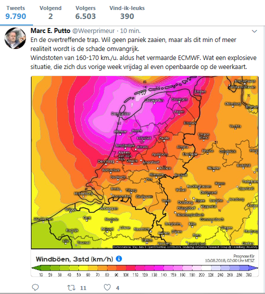
Ahh zie het ja, dit kaartje laat het windveld ten zuiden van de kern zien.quote:
[..]
Gezien de windrichting landen ze in Denemarken.
Wat zijn we aan het doen ???

Heftig kaartje,quote:
Ja CHAOS! Dag des doods voor Den Helder en de eilanden.
[ afbeelding ]
Overdreven waarschijnlijk, maar toch. wie weet
Ik ben rond 19.00 uur op de bank in slaap gekacheld na twee kutnachten, en nu ben ik klaarwakkerquote:
Ik kon gister niet slapen door onweer, regen en benauwdheid, was bij thuiskomst vanavond zo moe dat ik in slaap ben gedonderd en kan nu weer niet slapen omdat mijn ritme naar de tering is.
Topleven
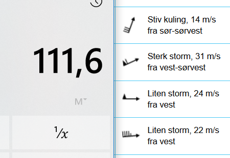
Yr.no maakt het bont met 111.6km/h wat gevaarlijk tegen een orkaankracht komt, en nee dit zijn geen windstoten 
In hoeverre we dit moeten vertrouwen is natuurlijk maar de vraag
In hoeverre we dit moeten vertrouwen is natuurlijk maar de vraag
Weerstation Dokkum voor het actuele weer in de Friese 11steden stad
Doe mee met het voorspellen van het weer!
Weekvoorspelling | Maandvoorspelling Augustus - Invullen tot 31 juli 23:59 | Jaarvoorspelling 2026
Doe mee met het voorspellen van het weer!
Weekvoorspelling | Maandvoorspelling Augustus - Invullen tot 31 juli 23:59 | Jaarvoorspelling 2026
13 graden hier buiten ik moet mijn dekbed weer van stal halen. Sterk storm dat begrijp ik er wel uit

Toch wel opvallend dat Estofex het lvl 2 gebied (op dit moment, verwachting van 0:33) aan de Nederlandse oostgrens laat ophouden, terwijl de rest van de verwachtingen het over het westen hebben.
Als het niet met een hamer te repareren is, is het een elektrisch probleem.
In het westen van Nederland is de temperatuur te laag en daardoor te weinig cape voor de echt zware buien met randactiviteiten. Wel kans op veel neerslag en een onweersklap. In het oosten maar vooral in Duitsland wordt het warmer en is er meer cape beschikbaar, daar kans op de zware onweersbuien.quote:
Toch wel opvallend dat Estofex het lvl 2 gebied (op dit moment, verwachting van 0:33) aan de Nederlandse oostgrens laat ophouden, terwijl de rest van de verwachtingen het over het westen hebben.
Voor de windstoten van vanavond/vannacht bij het doortrekken van het laagje geeft Estofex geen waarschuwing, omdat hier geen sprake is van convectieve buien. En Estofex geeft alleen waarschuwingen voor convectieve buien.
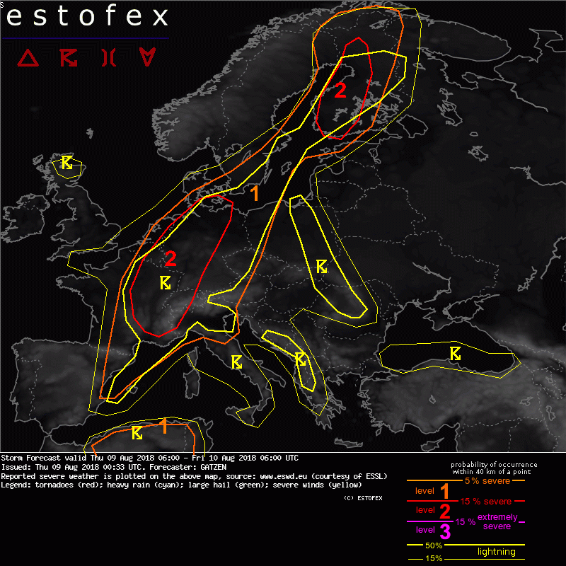
quote:A level 2 was issued across eastern France, Benelux, and north-west Germany mainly for severe wind gusts, excessive rain, and to a lesser extent tornadoes and large hail.
quote:North-eastern France, Benelux, north-western and northern Germany
Ahead of the approaching negatively tilted trough, a deepening surface low is expected to move from northern France to Denmark during the period. Backing surface winds to the north of this low cause moisture return into western Germany during the morning and noon. Additionally, strengthening southerly winds in the warm sector east of the low will cause steep lapse rates to spread northward from the Alpine region into Germany. With some diurnal heating, 1000 J/kg MLCAPE may be possible over western and central Germany. Farther west, both moisture return and lapse rate increase are a bit questionable. Latest models suggest that convective storms and stratiform rain will spread northward across the Benelux countries in the morning hours, limiting the chance of SBCAPE. Nonetheless, severe thunderstorms are not ruled out capable of producing severe wind gusts, excessive precipitation, and maybe a tornado. If backed surface winds can form in the afternoon hours and SBCAPE evolves far to the west across western Germany into the Benelux countries and north-eastern France, long and favourably curved hodographs will be supportive for well-organized storms including supercells. Severe wind gusts and tornadoes will be possible if this scenario comes true.
Strong or severe winds in the wake of the developing cyclone may occur but are not included in the threat levels since convective storms will be absent.
Farther east, partly linear organized clusters of storms are forecast that quickly spread north and north-east. Although deep layer vertical wind shear is below 20 m/s, supercells are not excluded that pose a threat of severe wind gusts, large hail, and tornadoes. Over northern Germany, clusters of storms may produce excessive precipitation. With strong low-level vertical wind shear, tornadoes are also possible with embedded supercells.
Op de site van Estofex staat toch echtquote:
[..]
In het westen van Nederland is de temperatuur te laag en daardoor te weinig cape voor de echt zware buien met randactiviteiten. Wel kans op veel neerslag en een onweersklap. In het oosten maar vooral in Duitsland wordt het warmer en is er meer cape beschikbaar, daar kans op de zware onweersbuien.
Voor de windstoten van vanavond/vannacht bij het doortrekken van het laagje geeft Estofex geen waarschuwing, omdat hier geen sprake is van convectieve buien. En Estofex geeft alleen waarschuwingen voor convectieve buien.
Als dit niet onder 'severe weather' valt weet ik het ook niet.quote:ESTOFEX products are issued to assist other meteorologists in forecasting severe weather.
* Resistor werpt nog een laatste blik op de partytent die zonder zichtbare scheerlijnen in een versteende tuin van buren staat, en gaat aan het werk
Als het niet met een hamer te repareren is, is het een elektrisch probleem.
quote:
[..]
Op de site van Estofex staat toch echt
[..]
Als dit niet onder 'severe weather' valt weet ik het ook niet.
* Resistor werpt nog een laatste blik op de partytent die zonder zichtbare scheerlijnen in een versteende tuin van buren staat, en gaat aan het werk
quote:Why does ESTOFEX not forecast all severe wind gusts and all precipitation, convective or not?
It was chosen not do this, because of limitations of our available time, and our wish to focus on deep organized convection. In addition this would require knowledge of local details in non-convective climatology at the scale of entire Europe (please consult your regional weather service). We are well aware that this selective approach creates problems in marginally convective/non-convective situations. In case of a storm depression with severe widespread winds, we issue threat levels when the forecast convective organization appears to be capable of enhancing the already severe "background" weather threat, for example by bow echoes and supercells. In such cases it is particularly recommended to read the forecast text, which conveys the total threat better than the choice of threat levels.
 Op
Op