WKN Weer, Klimaat en Natuurrampen
Lees alles over het onstuimige weer op onze planeet, volg orkanen en tornado's, zie hoe vulkanen uitbarsten en hoe Moeder Aarde beeft bij een aardbeving. Alles over de verwoestende kracht van onze planeet en tal van andere natuurverschijnselen.


Irma looms on the east coast Horizon...twitter:breakingweather twitterde op maandag 28-08-2017 om 10:05:22 The development of Tropical Storm Irma looms off the Southeast coast: https://t.co/64kdEG0bxy https://t.co/rYELO2pxq1 reageer retweet
 The development of Tropical Storm Irma looms off the Southeast coast:
Die wave die nu bij Afrika ligt kan ook gevaarlijk worden, voor de oostkust van de VS. EC heeft deze nu voor de Bahamas.
Lijkt erop dat dit ook een categorie 3 of meer gaat worden.
Lijkt erop dat dit ook een categorie 3 of meer gaat worden.
twitter:BNONews twitterde op woensdag 30-08-2017 om 14:55:20 Tropical Storm Irma forms in the Atlantic west of the Cabo Verde Islands; potential impact on the Caribbean or the U.S. not yet known - NHC reageer retweet
 Tropical Storm Irma forms in the Atlantic west of the Cabo Verde Islands; potential impact on the Caribbean or the U.S. not yet known - NHC
Kende je deze site al Frutsel? Hier kan je je eigen kaarten samenstellen. Er zijn echt tientallen parameters te kiezen.quote:Op woensdag 30 augustus 2017 14:57 schreef Frutsel het volgende:
twitter:BNONews twitterde op woensdag 30-08-2017 om 14:55:20 Tropical Storm Irma forms in the Atlantic west of the Cabo Verde Islands; potential impact on the Caribbean or the U.S. not yet known - NHC reageer retweet
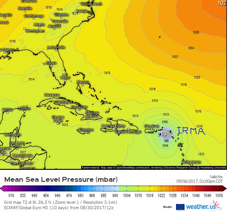
https://weather.us/model-charts/euro
Opgeblazen gevoel of winderigheid? Zo opgelost met Rennie!
quote:
Irma kan nog voor overlast zorgen langs de oostkust. En daarna Jose vanaf de Afrikaanse kust...
Never Stop Exploring!
Life begins at the end of your comfort zone!
Follow me on Twitter: https://twitter.com/EdwinKr83 Instagram: https://www.instagram.com/edwinkr83/
Life begins at the end of your comfort zone!
Follow me on Twitter: https://twitter.com/EdwinKr83 Instagram: https://www.instagram.com/edwinkr83/

Wordt hoe dan ook een pittige orkaan inderdaad, waar hij ook aan land mag gaan.
Opgeblazen gevoel of winderigheid? Zo opgelost met Rennie!
Accuweather schat de schade van Harvey op ...... 190 miljard

Bronquote:AccuWeather predicts Hurricane Harvey to be the most costly natural disaster in US history
August 30, 2017, 6:22:37 PM EDT
AccuWeather predicts Hurricane Harvey, which has wreaked havoc in Texas, to be the most costly natural disaster in United States history.
Dr. Joel N. Myers, founder, president and chairman of AccuWeather, and sometimes called the “father of commercial meteorology” stated, “This is the costliest and worst natural disaster in American history. AccuWeather has raised its estimate of the impact to the nation’s gross national produce, or GDP, to $190 billion or a full one percent, which exceeds totals of economic impact of Katrina and Sandy combined. The GDP is $19 trillion currently. Business leaders and the Federal Reserve, major banks, insurance companies, etc. should begin to factor in the negative impact this catastrophe will have on business, corporate earnings and employment. The disaster is just beginning in certain areas. Parts of Houston, the United States' fourth largest city will be uninhabitable for weeks and possibly months due to water damage, mold, disease-ridden water and all that will follow this 1,000-year flood.”
Due to the negative impact to the national economy, we believe the Federal Reserve will postpone the next increase in interest rates, Myers added.
Catastrophic flooding will continue in Houston, where the rain has ended, and in Beaumont and Port Arthur, Texas, to Lake Charles, Louisiana, even after the rain comes to an end.
“The meteorologist forecasting community as a whole did a very good job in warning people about this storm. Public officials were slow, in some cases, to react or to know what to do, which affected too many people and caused the loss of property and damage and destruction. This was unfortunate because when a natural disaster threatens, minutes and hours count and preparation and risk avoidance is imperative. While AccuWeather forecasts were a few hours ahead of the competition in alerting people and companies to the severity of the impacts that were coming. The entire meteorological community did a first rate job, and it’s frustrating that some entities were slow to take action. We are gratified that many people told us because of AccuWeather forecasts they did get to safety and out of harm’s way and many businesses we serve reported they took immediate action to minimize losses,” Myers said.


Die ook nog naar de oostkust VS en het wordt het zwaarste seizoen ooit.quote:
50% voor dat andere gebied dat vanaf Afrika komt, Jose komt eraan..
[ afbeelding ]

Gebeurt het vaak dat gebieden boven de Golf van 'gewone' storm uitgroeien tot orkaan? Ik dacht eigenlijk dat het vrijwel altijd boven de oceaan begon.
Dat gebeurd inderdaad wel vaker. Meestal hebben ze een langer pad vanuit de Caribbean of in de Stille Oceaan bijv richting Japan of Filipijnen maar zoals nu kunnen ze ook vanuit de Golf komen.quote:
Gebeurt het vaak dat gebieden boven de Golf van 'gewone' storm uitgroeien tot orkaan? Ik dacht eigenlijk dat het vrijwel altijd boven de oceaan begon.
Soms zijn het restanten vanuit het oostelijk deel van de Pacific die dan via Mexico of de Golf indruppelen en daar opnieuw tot ontwikkeling komen. Wel is daar de tijd voor ontwikkeling vaak geringer maar een traag systeem zoals Harvey krijgt juist door het warme zee water tijd genoeg. Er kunnen dus wel krachtige orkanen door ontstaan maar niet heel vaak.
De oost-pacifische stormen hoor je bijna nooit wat over omdat ze nooit land raken. Patricia was de laatste die echt naamsbekendheid kreeg vanwege de ongekende kracht.
Jose has formed....twitter:breakingweather twitterde op dinsdag 05-09-2017 om 17:01:13 BREAKING: Tropical Storm #Jose has formed over the eastern Atlantic Ocean: https://t.co/Oz0A0vrESz https://t.co/J5KJQWFW0Z reageer retweet

En orkaan Jose gaat achter Irma aan.
de verwachting is wel dat de orkaan vroegtijdig afbuigt naar het noordwesten
Maar de kans is aanwezig dat enkele eilandjes die nu ook door Irma zijn geraakt plukken van Jose gaan krijgen
de verwachting is wel dat de orkaan vroegtijdig afbuigt naar het noordwesten

Maar de kans is aanwezig dat enkele eilandjes die nu ook door Irma zijn geraakt plukken van Jose gaan krijgen


