WKN Weer, Klimaat en Natuurrampen
Lees alles over het onstuimige weer op onze planeet, volg orkanen en tornado's, zie hoe vulkanen uitbarsten en hoe Moeder Aarde beeft bij een aardbeving. Alles over de verwoestende kracht van onze planeet en tal van andere natuurverschijnselen.


Tornado's in de vroege ochtend zijn het zeldzaamst in de West North Central, Southwest en Northwest Climate regions, het meest frequent in de Southeast region en Dixie Alley.quote:Op dinsdag 14 februari 2017 16:52 schreef Nattekat het volgende:
Wordt steeds gekker. Eerst in februari, dan in de vroege ochtend.
De verdeling voor de South Climate region lijkt ongeveer overeen te komen met het gemiddelde voor de hele VS.
https://www.ncdc.noaa.gov(...)o-climatology/trends


are we infinite or am I alone

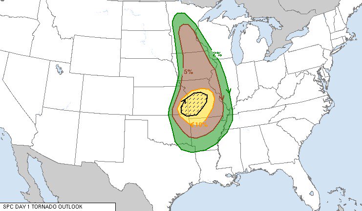
Weer een 'Enhanced Risk' voor vrijdag op zaterdag
[ Bericht 9% gewijzigd door Frutsel op 23-02-2017 08:58:10 ]


Ik las al berichten over een severe outbreak. Zou zo maar kunnen.
Temperatuurverschil is behoorlijk groot, dat kan voor enorme onweersbuien zorgen.
Temperatuurverschil is behoorlijk groot, dat kan voor enorme onweersbuien zorgen.

Voor vandaag. Enhanced risk.

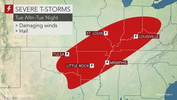
quote:Severe thunderstorms are expected to develop from portions of the
lower Mississippi Valley to the Ohio Valley Tuesday. Large hail,
damaging winds, and a few strong tornadoes are possible.


twitter:ReedTimmerAccu twitterde op dinsdag 28-02-2017 om 13:56:47 Expansive enhanced risk for severe weather, incl. potential for strong tornadoes from Ozarks thru southeast 1/2 of… https://t.co/u3JpdUY4HB reageer retweet
 Expansive enhanced risk for severe weather, incl. potential for strong tornadoes from Ozarks thru southeast 1/2 of…
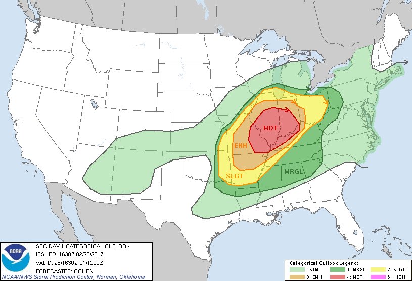

A Moderate Risk of Severe Thunderstorms is Forecast Today and/or Tonight
Severe thunderstorms are expected to develop from portions of the lower Mississippi Valley to the Ohio Valley through tonight. Strong tornadoes will be possible, especially across portions of the lower and middle Ohio Valley. Otherwise, large hail and damaging winds are expected.
Severe thunderstorms are expected to develop from portions of the lower Mississippi Valley to the Ohio Valley through tonight. Strong tornadoes will be possible, especially across portions of the lower and middle Ohio Valley. Otherwise, large hail and damaging winds are expected.
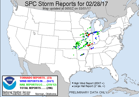
Gaat nu hard. Overal ontstaan zware cellen. Ook diverse splitsende cellen zichtbaar.
Melding van een funnel en ook hagel tot 2 inch.
Op dit moment 10 severe-warnings en 1 torando-warning.
Melding van een funnel en ook hagel tot 2 inch.
Op dit moment 10 severe-warnings en 1 torando-warning.
http://www.severe-weather(...)sa-february-28-2017/twitter:weermanreinier twitterde op woensdag 01-03-2017 om 12:25:12 Ongebruikelijke vroege en krachtige US & MidWest #Tornado Outbreak. Compilatie op: https://t.co/5hhx2Lot6y https://t.co/Enn3u1IXc3 reageer retweet
 Ongebruikelijke vroege en krachtige US & MidWest
Never Stop Exploring!
Life begins at the end of your comfort zone!
Follow me on Twitter: https://twitter.com/EdwinKr83 Instagram: https://www.instagram.com/edwinkr83/
Life begins at the end of your comfort zone!
Follow me on Twitter: https://twitter.com/EdwinKr83 Instagram: https://www.instagram.com/edwinkr83/
2quote:
1 dode afgelopen nacht.
http://www.chicagotribune(...)-20170228-story.html
twitter:CNNweather twitterde op woensdag 01-03-2017 om 14:34:33 22 tornadoes ripped through the Midwest Tuesday. More are possible today across the East. https://t.co/MDQ8HtzaqW https://t.co/OUyiyuE85u reageer retweet
 22 tornadoes ripped through the Midwest Tuesday. More are possible today across the East.
Never Stop Exploring!
Life begins at the end of your comfort zone!
Follow me on Twitter: https://twitter.com/EdwinKr83 Instagram: https://www.instagram.com/edwinkr83/
Life begins at the end of your comfort zone!
Follow me on Twitter: https://twitter.com/EdwinKr83 Instagram: https://www.instagram.com/edwinkr83/
3 inmiddels
quote:Tornadoes kill three in midwest
At least three people have been killed on Tuesday, February 28, 2017, as severe weather outbreak, including heavy rain, strong winds, and at least 7 tornadoes, rip through the US Midwest. As of March 1 at 07:00 UTC, the NWS has issued Flash Flood, Flood, Severe Thunderstorm and Tornado Warnings for the states of Illinois, Ohio, and Indiana. Events that took place in Illinois were extremely rare for February.
According to the National Weather Service, tornado spotters reported 23 twister sightings in Illinois, Missouri, Iowa, Tennessee and Indiana on Tuesday evening.
A large and dangerous tornado touched near Ottawa, 80 km (50 miles) southwest of Chicago, killing one person after the twister uprooted a tree. There are reports of minor injuries at an Ottawa nursing home.
At least a dozen vehicles, including a semi-truck, were blown off Interstate 55 near Perryville, Missouri, some 130 km (80 miles) of St. Louis, after a tornado touched down in the area. At least one person died and several were injured. Media reports mention 8 to 10 badly damaged buildings and structures. Perry County Clerk Jared Kutz says emergency management officials in the county aren't certain it was a tornado, but Missouri Gov. Eric Greitens says in a statement that there are confirmed reports of a tornado.
The third person was killed in Crossville, Illinois. He was found in a field behind his heavily damaged home. His wife sustained injuries and was taken to the hospital.

quote:Ravage in middenwesten VS na reeks tornado's
Enkele dagen na een reeks tornado's in het middenwesten van de VS, proberen inwoners in de staat Illinois de draad weer op te pakken. Het is er een ravage. "Ik hoorde een keiharde wind en een explosie van glas", zegt Debbie Loughridge, inwoner van Naplate, tegen persbureau AP. "Het was een oorverdovend geluid, alsof er een trein aankwam."
In Naplate staan ongeveer 200 huizen, zeker een kwart is verwoest, waaronder het huis van Loughridge. Toen de storm overtrok verschool ze zich met haar zoon in een badkuip. Ze werden uiteindelijk door de brandweer uit het huis bevrijd; een deel van het dak van hun huis was weggewaaid.
Ook andere plekken werden getroffen. In het noorden van Illinois kwam een man onder een omgewaaide boom terecht en overleed. En in de staat Missouri werd een aantal auto's van een schrootplaats geblazen. Een van de voertuigen raakte een automobilist, ook die man kwam om het leven.
Tornado's raasden ook over Tennessee en Iowa, maar volgens een brandweerwoordvoerder in Perryville viel het daar al met al mee met de schade. "Volgens mij mogen we van geluk spreken dat er niet nog meer slachtoffers zijn gevallen door deze ramp."
quote:Perryville tornado rated EF-4, the first violent tornado of 2017
The National Weather Service has upgraded the Perryville, Missouri tornado of February 28, 2017 to EF-4 today. This makes it the first violent tornado of 2017. The event lasted an astounding 1 hour and 2 minutes and was the longest track tornado in the coverage area of NWS Paducah since another EF-4 tornado back on April 22, 1981.
The tornado quickly became violent reaching EF-4 intensity and leveling 5 homes, as well as other structures, just west of I-55, about 5.6 km (3.5 miles) northwest of Perryville, Missouri. This is in the Kyle Lane and County Road 806 area, NWS explains.
Numerous uninhabited cars from a salvage yard were blown into or over I-55. The lone fatality occurred when an I-55 southbound vehicle was intercepted by the tornado.
As the tornado tore east, it caused the area of greatest home and property destruction 4.8 km (3 miles) north of Perryville, in the vicinity of U.S. Highway 61 and Moore Drive.
Three homes were leveled on the west side of U.S. Highway 61 with dozens of other homes and structures destroyed. Several of the injuries occurred in this area. In addition to the leveled homes in Perry County, at least 100 other homes received moderate to major damage.
As the tornado continued east across Perry County, it leveled or nearly leveled 2 additional homes and destroyed numerous other homes and structures. The tornado reached its greatest width as it approached the Mississippi River where a damage swath 965 m (0.6 miles) wide was measured.
The tornado damage path also exhibited multiple vortex characteristics at this point, yielding three distinct convergent areas within the parent vortex. This was also indicated via ground striations, or disturbance marks to bare ground, just west of the Mississippi River.
The twister then ripped across the southern tip of Randolph County Illinois just south of Rockwood and continued its ENE path across Jackson County, Illinois passing just south of Ava, Illinois and immediately south of Vergennes, Illinois.
Many thousands of large trees were snapped and uprooted, and dozens of homes and other structures were damaged or destroyed across Jackson and Franklin Counties.
The tornado remained very intense and wide (at least 0.5 km / 1/3 mile) nearly leveling a home as it passed between Elkville and Dowell, Illinois and into Franklin County with unabating intensity. A house was leveled 2.8 km (1.75 miles) south of Mulkeytown.
Very soon thereafter the tornado began to rapidly weaken, before dissipating 2.9 km (1.8 miles) southwest of Christopher.
The tornado lasted an astounding 1 hour and 2 minutes and was the longest track tornado in the coverage area of NWS Paducah since another EF-4 tornado back on April 22, 1981.
Quick facts:
Rating: EF-4
Estimated peak wind: 289 km/h (180 mph)
Path length /Statute/: 81.1 km (50.4 miles)
Path width /Maximum/: 965 m (0.6 miles)
Fatalities: 1
Injuries: 12
Start date/time: February 28, 19:55 CST (March 1, 01:55 UTC)
Start location: 7.7 km (4.8 miles) WNW of Perryville, Missouri
End date/time: February 28, 20:57 CST (March 1, 02:57 UTC)
End location: 2.9 km (1.8 miles) SW of Christopher, Illinois

quote:The 2017 tornado season is running far ahead of average
The highly progressive pattern that’s kept midlatitude storms shuttling across the United States all winter has given an early boost to the U.S. tornado season of 2017. Such a progressive pattern is important but not sufficient for producing early-season severe weather. Even if upper-level conditions favor severe weather, there may not be enough time between midlatitude storm systems for unstable air to flow back into place from the Gulf of Mexico. This year, however, the Gulf and Caribbean have been consistently warm, which has helped generate plenty of warm, moist air for midlatitude storms to access. In records back to 1981, this is the first year in which sea surface temperatures averaged across the entire Gulf never dropped below 73°F, as discussed by Eric Berger at ArsTechnica and shown in Figure 5 below (thanks to WU member Mark Cole for this tip). As of Monday, SSTs over the western Gulf were running 1°C - 2°C (1.8-3.6°F) above the seasonal norm.
Thus far in 2017, NOAA/SPC has logged 268 preliminary tornado reports. This is roughly double the average of 133 reports racked up by March 5 over the preceding 11 years (2005-2015). This year also stands out in a longer-term perspective, even after you “inflation-adjust” the data back to 1954 to account for the increased tendency since then for a given tornado to be spotted, chased, photographed, videotaped, etc. After the inflation adjustment, this year’s preliminary total of 228 tornado reports (see Figure 6 below) compares to a long-term average of just 69 reports by this point in the year.
twitter:MJVentrice twitterde op dinsdag 07-03-2017 om 11:06:20 Yesterday's 32 reported tornadoes was the most in the month of March since the infamous Mar 2, 2012 outbreak, which… https://t.co/ZoUCGYlMls reageer retweet
 Yesterday's 32 reported tornadoes was the most in the month of March since the infamous Mar 2, 2012 outbreak, which…