WKN Weer, Klimaat en Natuurrampen
Lees alles over het onstuimige weer op onze planeet, volg orkanen en tornado's, zie hoe vulkanen uitbarsten en hoe Moeder Aarde beeft bij een aardbeving. Alles over de verwoestende kracht van onze planeet en tal van andere natuurverschijnselen.


Denk het ook. Op veel plekken is die natuurlijk uitgevallen...quote:Op vrijdag 8 november 2013 08:13 schreef Perrin het volgende:
[..]
Geen electriciteit. Hopelijk hebben ze wel ergens een kelder ofzo gevonden, want ik denk dat in de buurt van het centrum van de storm (waar zijn geloof ik zitten) veel van die huisjes gewoon weg zullen zijn
Genealogie: Niet alleen voor oude knarren
Vergeet ook niet dat ze wel vaker met tyfonen te maken krijgen, die zijn het wel gewend. Dat deze een van de sterkste ooit is doet daar niets aan af.quote:
Ik vind het wel mooi om te zien dat men er nuchter onder blijft en er het beste van maakt.
[..]
Maar geen lange gezichten!.. Kunnen we hier nog wat van leren
Die doden zijn altijd treurig, hoop dat het mee zal vallen.
Genealogie: Niet alleen voor oude knarren


Dat is waar. Toch vond ik de foto's een waar genoegen eigenlijk (ondanks de overduidelijke ernst natuurlijk)quote:Op vrijdag 8 november 2013 08:17 schreef Olga het volgende:
[..]
Vergeet ook niet dat ze wel vaker met tyfonen te maken krijgen, die zijn het wel gewend. Dat deze een van de sterkste ooit is doet daar niets aan af.
Meestal proberen ze het zo dramatisch mogelijk weer te geven, en dan vind ik dit een welkome afwisseling.
“When there is no desire, all things are at peace.”

Oeps.. Zijn de verkeerde foto's zie ik net..  Deze zijn van die van augustus!
Helaas overheen gekeken.
Dan kan ik ze beter maar verwijderen.
Helaas overheen gekeken.
Dan kan ik ze beter maar verwijderen.
“When there is no desire, all things are at peace.”
Fokking hell zeg wat een monster is dat uiteindelijk gebleven... ik had er nog enigszins hoop op dat de destijds categorie 4 orkaan bij de landfall een cat.3 zou worden maar dit zag eruit als een cat.5 landfall 
Zijn daar trouwens wel goed voorbereid omdat ze jaarlijks een paar keer worden getroffen maar dit geweld slaat alles
Zijn daar trouwens wel goed voorbereid omdat ze jaarlijks een paar keer worden getroffen maar dit geweld slaat alles


http://www.bbc.co.uk/news/world-asia-24863480quote:The BBC's Jon Donnison in Manila says things are looking "bleak" and due to broken communications with villages it could be days before we know the full extent of the damage.
And what rough beast, its hour come round at last,
Slouches towards Bethlehem to be born?
Slouches towards Bethlehem to be born?
Meer hierquote:Supertyphoon Haiyan hits Philippines
With sustained winds of more than 310 km/h, or 195 mph, as it approached the Philippines, Super Typhoon Haiyan has hit land in the past few hours with terrifying force. This makes it the strongest tropical cyclone to make landfall in history.
Haiyan was earlier reported to be the most intense tropical storm in this area since Super Typhoon Tip (1979), and may even have exceeded the force of Tip. It had already been recognised to be one of the four most intense storms on modern record.
Preliminary satellite estimates of the central pressure at the eye of the storm have been reported at around 860 mbar, which if confirmed would make Haiyan the strongest storm ever recorded. Its intensity is recorded as Category 5 (maximum) on the scale for tropical storms and 8.0 (maximum) on the Dvorak scale of intensity.
En dat raakt dus een behoorlijk kwetsbaar gebied. Ik vrees duizenden, zo niet tienduizenden slachtoffersquote:
And what rough beast, its hour come round at last,
Slouches towards Bethlehem to be born?
Slouches towards Bethlehem to be born?
Ergens zaten er in ieder geval 5000 mensen in geimproviseerde hutjes en tentjes na een aardbeving idd.. 
"Light thinks it travels faster than anything. It doesn't. For wherever light travels it finds darkness has got there first and is waiting for it."
Het schijnt in Tacloban, waar ook de twee stormchasers zijn, heel erg te zijn.
http://anc.yahoo.com/vide(...)-city-014609542.html
Die reporter
http://anc.yahoo.com/vide(...)-city-014609542.html
Die reporter
Genealogie: Niet alleen voor oude knarren
wtfquote:
Het schijnt in Tacloban, waar ook de twee stormchasers zijn, heel erg te zijn.
http://anc.yahoo.com/vide(...)-city-014609542.html
Die reporter
JamesReynolds is een beetje de Reed Timmer van de orkanen volgens mij
Tagalog klinkt wel heel vreemd trouwens.quote:
Het schijnt in Tacloban, waar ook de twee stormchasers zijn, heel erg te zijn.
http://anc.yahoo.com/vide(...)-city-014609542.html
Die reporter
Baat 't niet, schaadt 't niet. Dus slikken, kreng.
Ter vergelijking: Landfall zou zijn geweest met snelheden van ca 310 km/u?
Katrina was 205 km/u bij landfall
Katrina was 205 km/u bij landfall
Yep.
"Light thinks it travels faster than anything. It doesn't. For wherever light travels it finds darkness has got there first and is waiting for it."

De mensen zijn persoonlijk wel voorbereid en optimistisch, maar ieta grootschaligs organiseren, zoals een evacuatie, is heel lastig op de Filipijnen. Met een beetje pech zal dit een enorme ramp gaan worden 
En het blijft Azie he.. altijd glimlachen, waarschijnlijk meer uit angst en verdriet.
"Light thinks it travels faster than anything. It doesn't. For wherever light travels it finds darkness has got there first and is waiting for it."
quote:
[..]
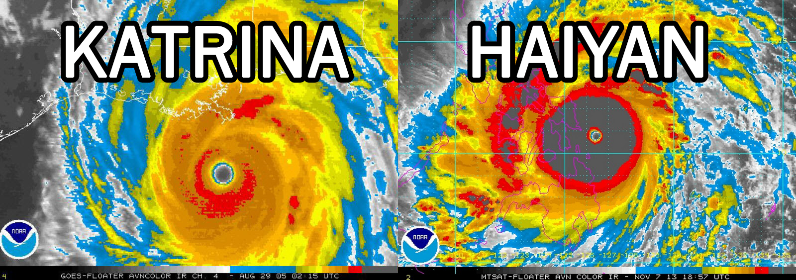
Hoe moet ik deze kaartjes zien, staan de kleuren voor windsnelheden?
Of voor neerslag?
http://www.newrepublic.co(...)among-strongest-everquote:You’re looking at an infrared satellite image. Counter-intuitively, the “red” clouds are actually the coldest—that means they’re very tall clouds, so tall that the temperature is about -70 Celsius. These clouds are so tall that they’re bumping up and even through the “tropopause,” where the troposphere ends and stratosphere begins.
Look at Katrina’s eye. It’s perfectly round. The center is black, meaning there are only a few low clouds near the surface. The inner-eye wall looks like a series of concentric rings, steadily moving up the color scale. The eye is surrounded by a symmetric, thick, intense ring of strong thunderstorms, called the “central dense overcast.”
A perfectly well-defined eye, like Katrina's, is characteristic of a very strong Category 4 or 5 Hurricane. It’s not necessary for a storm to be a strong 4 or 5, but it is basically sufficient.
From there, the height of the clouds in the central dense overcast gives you a sense of whether it’s a strong 5 (completely surrounded by red) or a strong 4 (perhaps no red at all). Why does it matter if the clouds are tall? Think about the idea of “low pressure": If the pressure is low at the surface, where did all of that air go? The answer is “up,” by means of the updrafts producing those tall thunderstorms, and then out—you can see the “outflow” along the periphery of the storm, those whispy, white clouds along the edge. That's basically the “exhaust” of the storm.
"Light thinks it travels faster than anything. It doesn't. For wherever light travels it finds darkness has got there first and is waiting for it."