WKN Weer, Klimaat en Natuurrampen
Lees alles over het onstuimige weer op onze planeet, volg orkanen en tornado's, zie hoe vulkanen uitbarsten en hoe Moeder Aarde beeft bij een aardbeving. Alles over de verwoestende kracht van onze planeet en tal van andere natuurverschijnselen.


Ritje NY chasing? 
Weerstation Dokkum voor het actuele weer in de Friese 11steden stad
Doe mee met het voorspellen van het weer!
Weekvoorspelling | Maandvoorspelling Augustus - Invullen tot 31 juli 23:59 | Jaarvoorspelling 2026
Doe mee met het voorspellen van het weer!
Weekvoorspelling | Maandvoorspelling Augustus - Invullen tot 31 juli 23:59 | Jaarvoorspelling 2026

quote:Orkaan Sandy potentieel gevaarlijk
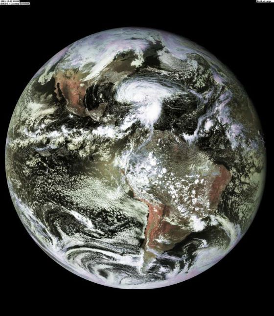
Orkaan Sandy trekt verder noordwaarts richting de Bahamas als cat2 orkaan. Vervolgens is een afzwakking voorzien tot een cat1 orkaan wanneer de orkaan net oost van het Noord-Amerikaanse continent trekt. Het lijkt er volgens de modellen steeds meer op dat de orkaan net niet als cat1 orkaan aan land gaat in het noordoosten van de USA, waarbij de orkaan een onmiddellijke dreiging kan vormen voor de daar zeer dichtbevolkte gebieden. Dit zou ergens tegen volgende dinsdag gebeuren.
Naast de felle wind zal de orkaan zeer veel regen veroorzaken in deze gebieden. GFS berekent een kerndruk rond 940 hPa wanneer de depressie aan land gaat. Ook de laatste middagrun van het Europese model geeft aan dat deze orkaan aan land gaat met erg lage druk en met bakken regen voor de kustgebieden.
De orkaan wordt als het ware meegetrokken in een reeds aanwezige hoogtetrog over de USA waardoor de storm afwijkt van de meer gangbare koers noordoostwaarts.
bron
 Op
Op
Zou best kunnen idd.quote:Op donderdag 25 oktober 2012 21:09 schreef YazooW het volgende:
[..]
Zou me niks verbazen als dit gevolgen gaat hebben voor de verkiezingen daar.
Nog een webcam: Miami Beach
Zijn nog meer te vinden op deze site.
Man, wat een boel regen hier in Miami. Net een echte herfstdag in Nederland, maar dan met 25 graden  Alleen jammer dat ik dus weinig zie van Miami...
The line is a dot to you!

quote:At 11 a.m. EDT, tropical-storm-force winds extended up to 140 miles (220 km) from the center, making Sandy more than 280 miles in diameter. By 2 p.m. EDT, just more than three hours later, Sandy had grown. Sandy's tropical storm-force-winds now extend outward up to 205 miles (335 km) from the center, making the storm about 410 miles in diameter.
High res foto 7400x9800
http://www.nasa.gov/missi(...)012/h2012_Sandy.html
quote:SANDY IS EXPECTED TO GROW LARGER IN SIZE DURING THE
NEXT COUPLE OF DAYS.
http://www.nhc.noaa.gov/text/refresh/MIATCPAT3+shtml/252035.shtml
Bizar... Ben benieuwd of het echt uitkomt...quote:Isn't it strange that a hurricane in the Bahamas would somehow turn into a monster mega-storm and slam into the Northeast at the end of October? Aren't hurricanes supposed to weaken as they move north over cold water? What the hell is going on?
The answers are... yes, yes, and we're not completely sure. This is a beyond-strange situation. It's unprecedented and bizarre. Hurricanes almost always bend out to sea in October, although there have been some exceptions when storms went due north, but rarely. No October tropical systems in the record book have turned left into the northeast coast.
The strong evidence we have that a significant, maybe historic, storm is going to hit the east coast is that EVERY reliable computer forecast model now says it's going to happen. The only way we can forecast the weather four or five days days from now is with the aid of these super-complex computer programs run on supercomputers. The two best, the European and the U.S. GFS (Global Forecast System) run by NOAA, are now in reasonable agreement that there IS going to be an extraordinarily unusual confluence of events that results in a massive storm.
The upper-air steering pattern that is part of the puzzle is not all that unheard of. It happens when the atmosphere gets blocked over the Atlantic and the flow over the U.S. doubles back on itself. Sometimes big winter storms are involved.
The freak part is that a hurricane happens to be in the right place in the world to get sucked into this doubled-back channel of air and pulled inland from the coast.
And the double-freak part is that the upper level wind, instead of weakening the storm and simply absorbing the moisture - which would be annoying enough - is merging with the tropical system to create a monstrous hybrid vortex. A combination of a hurricane and a nor'easter.
At least that's what the models are saying. And since all of the independent models are saying something similar, we have to believe them and be ready.
For most people being ready means getting to the store and getting stuff before everybody else gets wise and gets the stuff first. The forecast is for an incredibly widespread and long-duration windstorm, meaning power will likely be out for an extended period of time in a lot of locations.
A transistor radio is your best friend in a situation like this. Get one and enough batteries to keep it going. Your cell phone may or may not be your friend after a big storm.
For people near the coast, it's critical that you pay attention to local evacuation orders and emergency information. This storm, as forecast, will create dangerous and potentially life-threatening storm surge along hundreds of miles of coastline north of where the center comes ashore. Big storms move a lot of water, and this one is about as big as they come.
Right now, it looks like the storm center will land between the Delmarva and New Jersey, which would put the entire Tri-State area of NJ, NY, and Connecticut on the bad side of the storm. The Jersey Shore, Long Island, and New York City itself would be exposed to the brunt of the storm surge due to the "L" in the coastline at NYC. The angle and duration of the wind will keep the water high for an extended period of time, if this comes together as forecast. This means transportation disruptions and widespread coastal damage.
If the storm comes in farther south, the Delmarva, Delaware Bay and maybe the Chesapeake will be at risk. A storm the size that's forecast would cause problems throughout New England as well, even if the center is south of New York. And then there is the threat from flooding rain and the extremely heavy snow well inland.
To make all this worse along the coast, the moon is full on Monday, meaning the high tides will be higher yet.
The hope we have is that the computer models are not handling this unusual situation well, and are predicting a stronger storm than we get. But, we can't bet of it. Even a weaker version will likely mean a nightmare for millions.
The line is a dot to you!
Sandy eist 11 levens op Cuba
De orkaan Sandy heeft op Cuba aan zeker 11 mensen het leven gekost. De orkaan had een kracht van de tweede categorie toen hij over het eiland trok.
De meeste doden vielen in het oosten van het land. Onder hen was een baby van vier maanden en een bejaarde van 84. De meeste slachtoffers kwamen om doordat ze bedolven raakten onder brokstukken.
Bahama's
Sandy is verder noordwaarts getrokken en ligt nu in de buurt van de Bahama's.
Op Haiti kwamen 9 mensen om door het noodweer. Een man en twee vrouwen probeerden een rivier over te steken en werden meegesleurd door het woeste water.
In Jamaica wordt inmiddels opgeruimd. Sandy kwam woensdag over als orkaan in de eerste categorie. De schade is minder groot dan gevreesd, maar de volledige omvang ervan is nog niet duidelijk, zo benadrukken autoriteiten.
Jamaica
Het natuurgeweld eiste op Jamaica één leven. Zo'n 70 procent van het eiland kwam zonder elektriciteit te zitten. Ook was er in veel steden geen water meer.
Verwacht wordt dat Sandy orkaankracht houdt gedurende een aantal dagen. De komende uren zal de kracht wel iets afnemen.
Mogelijk zal de orkaan de oostkust van de Verenigde Staten nog aandoen.
nos


Landfall nabij New Jersey aldus deze prognose. Europese model zit nu iets zuidelijker, GFS meer noordelijker.


quote:Worst Storm in 100 Years Seen for Northeast U.S.
Hurricane Sandy will probably grow into a “Frankenstorm” that may become the worst to hit the U.S. Northeast in 100 years if current forecasts are correct.
Sandy may combine with a second storm coming out of the Midwest to create a system that would rival the New England hurricane of 1938 in intensity, said Paul Kocin, a National Weather Service meteorologist in College Park, Maryland. The hurricane currently passing the Bahamas has killed 21 people across the Caribbean, the Associated Press reported, citing local officials.
“What we’re seeing in some of our models is a storm at an intensity that we have not seen in this part of the country in the past century,” Kocin said in a telephone interview yesterday. “We’re not trying to hype it, this is what we’re seeing in some of our models. It may come in weaker.”
The hybrid storm may strike anywhere from the Delaware- Maryland-Virginia peninsula to southern New England. The current National Hurricane Center track calls for the system to go up Delaware Bay and almost directly over Wilmington, Delaware, just southwest of Philadelphia, on Oct. 30-31.
And what rough beast, its hour come round at last,
Slouches towards Bethlehem to be born?
Slouches towards Bethlehem to be born?


Wow, recht op Washington af? En ook NY is gonna get it als ik dat zo zie... het midden van de wall er recht overheen 
"Light thinks it travels faster than anything. It doesn't. For wherever light travels it finds darkness has got there first and is waiting for it."
In Miami merk ik er weinig van, zon schijnt nu zelfs. Wind is wel aan het toenemen, maar veel wil ik het nog niet noemen (zou vanavond moeten toenemen.)quote:e.net/p/2s.gif[/img] Op 26 oktober 2012 20:11 schreef aloa het volgende:
Gaat flink tekeer hier in Florida
http://www.surfguru.com/florida-surf-reports/new-smyrna-beach
The line is a dot to you!
Mocht hij wat verschuiven dan zijn de gevolgen nog steeds groot; wat verder naar het noorden heb je Boston, wat verder naar het zuiden heb je Philadelphia en nog wat verder naar het zuiden Washington.twitter:BigJoeBastardi twitterde op vrijdag 26-10-2012 om 21:12:40 ECMWF has shifted further north and the witches brew of modeling now has New York City as the center of the pick your poison potion reageer retweet
 ECMWF has shifted further north and the witches brew of modeling now has New York City as the center of the pick your poison potion


Amerikaanse oostkust bereidt zich voor op krachtige 'Frankenstorm'
UPDATE De kans dat er een nieuwe 'perfect storm' zal ontstaan langs de oostkust van Amerika is nu 90 procent. Meteorologen vrezen dat de storm de regio zal teisteren tot aan de presidentsverkiezingen op 6 november. De storm kreeg al de bijnaam 'Frankenstorm', omdat in de VS binnenkort ook Halloween wordt gevierd. In de staat New York, waar de storm een van de komende dagen wordt verwacht, is intussen de noodtoestand afgekondigd.
Een 'perfect storm' ontstaat wanneer drie weersomstandigheden samenkomen: warme lucht uit een lagedrukgebied, koele en droge lucht uit een hogedrukgebied en een tropische orkaan, in dit geval de orkaan Sandy. Ze trok al over de Caraïben, waar minstens 38 doden vielen, en werkt zich nu een weg naar het noorden.
Begin volgende week
Intussen trekt een vroege winterstorm oostwaarts over de VS. En vanuit Canada trekt een koudefront richting zuiden. Het ziet ernaar uit dat die weersverschijnselen begin volgende week allemaal op elkaar zullen botsen, waarschijnlijk in de buurt van New York of New Jersey.
Andrew Cuomo, de gouverneur van de staat New York, heeft gisteren alvast de noodtoestand uitgeroepen. De politicus nam de maatregel om ervoor te zorgen dat de staat "zich kan voorbereiden op de potentiële impact van de orkaan", zo bleek uit een mededeling.
De burgemeester van de stad New York, Michael Bloomberg, verduidelijkte tijdens een persconferentie dat de lokale overheden verwachten dat de doortocht van de orkaan Sandy zondagavond zal plaatsvinden. Hij waarschuwde dat het gaat om een "erg gevaarlijks storm" en riep de bevolking op om de overheidsinformatie aandachtig in de gaten te houden.
Intussen is in de stad het Coastal Storm Plan in werking gezet. Alle belangrijke stadsdiensten zijn opgeroepen om zich op het ergste voor te bereiden. Mogelijk wordt ook al het metro- en busverkeer stilgelegd.
Volle maan
De vorige 'perfect storm' dateert van 1991, en sloeg ook met Halloween toe. Het werd er eentje voor in de geschiedenisboeken, met golven van dertig meter die de vissersvloot op de Grand Banks overvielen, iets waar onder meer een succesvolle Hollywoodfilm uit voortvloeide. "Dit dreigt een extreme, belangrijke en historische storm te worden", meldt Brian McNoldy van de University of Miami. "De condities zijn identiek aan 1991."
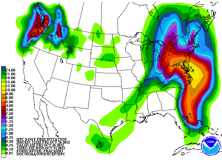
Meteorologen voorspellen een gigantische storm met vijf à zes dagen dagen zware regen, hevige winden en aan de kust grote vloedgolven. De storm zal ook toeslaan tijdens een volle maan, met springtij, wat het risico op overstromingen en dijkbreuken aan de kust alleen maar groter maakt. In de hoger gelegen gebieden van Oost-Ohio, het zuidwesten van Pennsylvania, het westen van Virginia en de Shenandoah Mountains zal er wellicht veel sneeuw vallen, wat dan weer een hoop ellende met onder meer de stroomvoorziening kan veroorzaken.
Er wordt nu al uitgegaan van een minimale schade van een miljard dollar.
hln

UPDATE De kans dat er een nieuwe 'perfect storm' zal ontstaan langs de oostkust van Amerika is nu 90 procent. Meteorologen vrezen dat de storm de regio zal teisteren tot aan de presidentsverkiezingen op 6 november. De storm kreeg al de bijnaam 'Frankenstorm', omdat in de VS binnenkort ook Halloween wordt gevierd. In de staat New York, waar de storm een van de komende dagen wordt verwacht, is intussen de noodtoestand afgekondigd.
Een 'perfect storm' ontstaat wanneer drie weersomstandigheden samenkomen: warme lucht uit een lagedrukgebied, koele en droge lucht uit een hogedrukgebied en een tropische orkaan, in dit geval de orkaan Sandy. Ze trok al over de Caraïben, waar minstens 38 doden vielen, en werkt zich nu een weg naar het noorden.
Begin volgende week
Intussen trekt een vroege winterstorm oostwaarts over de VS. En vanuit Canada trekt een koudefront richting zuiden. Het ziet ernaar uit dat die weersverschijnselen begin volgende week allemaal op elkaar zullen botsen, waarschijnlijk in de buurt van New York of New Jersey.
Andrew Cuomo, de gouverneur van de staat New York, heeft gisteren alvast de noodtoestand uitgeroepen. De politicus nam de maatregel om ervoor te zorgen dat de staat "zich kan voorbereiden op de potentiële impact van de orkaan", zo bleek uit een mededeling.
De burgemeester van de stad New York, Michael Bloomberg, verduidelijkte tijdens een persconferentie dat de lokale overheden verwachten dat de doortocht van de orkaan Sandy zondagavond zal plaatsvinden. Hij waarschuwde dat het gaat om een "erg gevaarlijks storm" en riep de bevolking op om de overheidsinformatie aandachtig in de gaten te houden.
Intussen is in de stad het Coastal Storm Plan in werking gezet. Alle belangrijke stadsdiensten zijn opgeroepen om zich op het ergste voor te bereiden. Mogelijk wordt ook al het metro- en busverkeer stilgelegd.
Volle maan
De vorige 'perfect storm' dateert van 1991, en sloeg ook met Halloween toe. Het werd er eentje voor in de geschiedenisboeken, met golven van dertig meter die de vissersvloot op de Grand Banks overvielen, iets waar onder meer een succesvolle Hollywoodfilm uit voortvloeide. "Dit dreigt een extreme, belangrijke en historische storm te worden", meldt Brian McNoldy van de University of Miami. "De condities zijn identiek aan 1991."
Meteorologen voorspellen een gigantische storm met vijf à zes dagen dagen zware regen, hevige winden en aan de kust grote vloedgolven. De storm zal ook toeslaan tijdens een volle maan, met springtij, wat het risico op overstromingen en dijkbreuken aan de kust alleen maar groter maakt. In de hoger gelegen gebieden van Oost-Ohio, het zuidwesten van Pennsylvania, het westen van Virginia en de Shenandoah Mountains zal er wellicht veel sneeuw vallen, wat dan weer een hoop ellende met onder meer de stroomvoorziening kan veroorzaken.
Er wordt nu al uitgegaan van een minimale schade van een miljard dollar.
hln
quote:Sandy zwakt af tot tropische storm
Toegevoegd: zaterdag 27 okt 2012, 11:58
De orkaan Sandy, die waarschijnlijk maandag de Amerikaanse oostkust bereikt, is afgezwakt tot een tropische storm. Dat meldt het National Hurricane Centre.
Meteorologen hielden rekening met een scenario dat Sandy zich onder invloed van een krachtig koufront zou ontwikkelen tot een superstorm. Media in de Verenigde Staten hadden Sandy al omgedoopt tot "Frankenstorm". Volgens de laatste voorspelling lijkt het dus mee te vallen, al kan ook een tropische storm nog veel schade veroorzaken. Veel bomen staan nog in blad en kunnen daardoor gemakkelijk omver worden geblazen.
Waar Sandy precies aan land komt is nog niet duidelijk. De computermodellen geven nog geen uitsluitsel. De overlast aan de oostkust zal waarschijnlijk enkele dagen duren doordat Sandy zich maar langzaam verplaatst.
Sandy heeft ook gevolgen voor de slotfase van de campagne voor de presidentsverkiezingen. Zo heeft de Republikein Mitt Romney een bijeenkomst die voor zondagavond in de staat Virginia gepland stond afgelast.
Sandy heeft in het Caraïbisch gebied een spoor van vernielingen aangericht, vooral in Cuba en Haïti. Zeker 40 mensen zijn daar om het leven gekomen.
Say what?