WKN Weer, Klimaat en Natuurrampen
Lees alles over het onstuimige weer op onze planeet, volg orkanen en tornado's, zie hoe vulkanen uitbarsten en hoe Moeder Aarde beeft bij een aardbeving. Alles over de verwoestende kracht van onze planeet en tal van andere natuurverschijnselen.


Nemen inmiddels al weer af. Gok dat ze over 2 uur weer op nagenoeg nul zitten.
Over de laatste paar dagen zie ik wel dat de tremors zichtbaar zwaarder worden.
eens kijken of ik wat kan knippen en plakken
[ Bericht 46% gewijzigd door bwt op 01-02-2012 17:01:06 ]
Over de laatste paar dagen zie ik wel dat de tremors zichtbaar zwaarder worden.
eens kijken of ik wat kan knippen en plakken
[ Bericht 46% gewijzigd door bwt op 01-02-2012 17:01:06 ]
<a href="http://goo.gl/q8fhTe" target="_blank">FAQ?</a>
<a href="http://goo.gl/gYvZFq" target="_blank">Geel is een zonnige en vrolijke kleur, als hij tenminste enigszins warm is gekleurd en wat naar het oranje neigt</a>
<a href="http://goo.gl/gYvZFq" target="_blank">Geel is een zonnige en vrolijke kleur, als hij tenminste enigszins warm is gekleurd en wat naar het oranje neigt</a>
en deze van Earthquake reportquote:Eruptive swell in Restinga. No, now is not outpourings of balls. This is a wave produced in situ by the volcano, which must have won meters in height and comes to the surface very slowly. (JR)
Klik om te vergroten


met video
[ Bericht 18% gewijzigd door bwt op 01-02-2012 20:22:58 ]
<a href="http://goo.gl/q8fhTe" target="_blank">FAQ?</a>
<a href="http://goo.gl/gYvZFq" target="_blank">Geel is een zonnige en vrolijke kleur, als hij tenminste enigszins warm is gekleurd en wat naar het oranje neigt</a>
<a href="http://goo.gl/gYvZFq" target="_blank">Geel is een zonnige en vrolijke kleur, als hij tenminste enigszins warm is gekleurd en wat naar het oranje neigt</a>
valt mee de afname... dit keer blijft het onrustig en sterker dan gisterquote:Op woensdag 1 februari 2012 16:38 schreef bwt het volgende:
Nemen inmiddels al weer af. Gok dat ze over 2 uur weer op nagenoeg nul zitten.
Over de laatste paar dagen zie ik wel dat de tremors zichtbaar zwaarder worden.
eens kijken of ik wat kan knippen en plakken

[ Bericht 10% gewijzigd door Jumparound op 02-02-2012 10:48:15 ]
Inorbit: zeg dat dan typluie triangeljosti
Beauregard: Een beetje FOK!ker laat het brood door z'n moeder smeren.
Ecosia
ek's 'n flash drive, jy's 'n floppy
Beauregard: Een beetje FOK!ker laat het brood door z'n moeder smeren.
Ecosia
ek's 'n flash drive, jy's 'n floppy
ik weet niet of ie zichtbaar is...
de laatste 3 dagen
de laatste 3 dagen

Inorbit: zeg dat dan typluie triangeljosti
Beauregard: Een beetje FOK!ker laat het brood door z'n moeder smeren.
Ecosia
ek's 'n flash drive, jy's 'n floppy
Beauregard: Een beetje FOK!ker laat het brood door z'n moeder smeren.
Ecosia
ek's 'n flash drive, jy's 'n floppy
Was gister niet meer gelukt om de knippen en plakken. thnx @jumparaound
Het valt me ook op dat de tremmors niet tot bijna nul meer terug vallen maar goed aanwezig blijven.
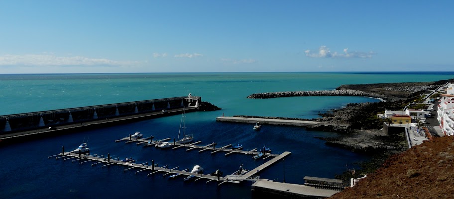
Het groene water zit inmiddels ook weer in de haven van La Restinga
[ Bericht 43% gewijzigd door bwt op 02-02-2012 13:12:00 ]
Het valt me ook op dat de tremmors niet tot bijna nul meer terug vallen maar goed aanwezig blijven.
Het groene water zit inmiddels ook weer in de haven van La Restinga
quote:NOTE AVCAN 437 - EARTHQUAKE ACTIVITY-VOLCANIC - HIERRO ISLAND - FEBRUARY 02 2012-12:00 h peninsular - seismic-volcanic activity continues to moderate, with seismicity located today in the western el Golfo Coast marine and yesterday in the Sea of las Calmas, and some non-localized microseismicity. Continued volcanic tremor signal in the eruption of the Restinga, which is increasing its activity, because since yesterday at 07:00 h restart has not stopped, as he had done the previous days, the explosion seems to have fallen somewhat , are less hydromagmatic explosions. La Mancha output produced by the underwater material is larger and this morning has gotten into the port of La Restinga. Magnitude between 1.6 and 0.9. New earthquakes 5. Depths to 10.1, 12.2, 12.5, 13.1 and 14.8km. The day before yesterday 14. Yesterday 5. Now go 3. A total of 12,121 earthquakes are located in El Hierro by IGN from 9:00 am of July 19, 2011 (Enrique).
DAY 02 FEB EARTHQUAKES. - Yellow (3)
DAY 01 FEB EARTHQUAKES. - Light Green (5)
DAY 31 JAN EARTHQUAKES. - Red (14)
DAY 30 JAN EARTHQUAKES. - Light Blue (13)
DAY 29 JAN EARTHQUAKES. - Rosa (16)
Earthquakes today are three in the el Golfo area, aligned NW-SE, from the coast toward the front of the Tanganasoga NW. The seismicity forms a spiral, with three distinct NNE-SSW alignment, NS and NNW-SSE from all the Tanganosoga and two arms, one to the north towards the W in the area where the swarm began and another in the south to eruptive area. It also highlights other alignments in the direction WNW-ESE in the line of summits and on the coast of Julan.
1124573 01/02/2012 19:04:30 27.6818 -18.0607 12.5 1.6 mbLg SW EL PINAR.IHI
1124576 01/02/2012 22:22:24 27.6713 -18.0179 10.1 1.0 mbLg SW EL PINAR.IHI
1124579 02/02/2012 00:36:57 27.7451 -18.0635 12.2 1.1 mbLg W FRONTERA.IHI
1124583 02/02/2012 04:40:59 27.7527 -18.0696 13.1 0.9 mbLg W FRONTERA.IHI 12120
1124584 02/02/2012 04:41:44 27.7683 -18.0854 14.8 1.1 mbLg W FRONTERA.IHI

[ Bericht 43% gewijzigd door bwt op 02-02-2012 13:12:00 ]
<a href="http://goo.gl/q8fhTe" target="_blank">FAQ?</a>
<a href="http://goo.gl/gYvZFq" target="_blank">Geel is een zonnige en vrolijke kleur, als hij tenminste enigszins warm is gekleurd en wat naar het oranje neigt</a>
<a href="http://goo.gl/gYvZFq" target="_blank">Geel is een zonnige en vrolijke kleur, als hij tenminste enigszins warm is gekleurd en wat naar het oranje neigt</a>
Mooie foto van het groen in de haven. (van Earthquake report, zelfs AVCAN linkt er naar op de FaceBook pagina)
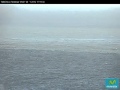
Was op de webcam ook mooi te zien
Deze foto wil ik graag in de 1e post/OP zetten. maar mag niet meer editten.
Was op de webcam ook mooi te zien
Deze foto wil ik graag in de 1e post/OP zetten. maar mag niet meer editten.
<a href="http://goo.gl/q8fhTe" target="_blank">FAQ?</a>
<a href="http://goo.gl/gYvZFq" target="_blank">Geel is een zonnige en vrolijke kleur, als hij tenminste enigszins warm is gekleurd en wat naar het oranje neigt</a>
<a href="http://goo.gl/gYvZFq" target="_blank">Geel is een zonnige en vrolijke kleur, als hij tenminste enigszins warm is gekleurd en wat naar het oranje neigt</a>

En het gaat maar door ;-)
Inorbit: zeg dat dan typluie triangeljosti
Beauregard: Een beetje FOK!ker laat het brood door z'n moeder smeren.
Ecosia
ek's 'n flash drive, jy's 'n floppy
Beauregard: Een beetje FOK!ker laat het brood door z'n moeder smeren.
Ecosia
ek's 'n flash drive, jy's 'n floppy

<a href="http://goo.gl/q8fhTe" target="_blank">FAQ?</a>
<a href="http://goo.gl/gYvZFq" target="_blank">Geel is een zonnige en vrolijke kleur, als hij tenminste enigszins warm is gekleurd en wat naar het oranje neigt</a>
<a href="http://goo.gl/gYvZFq" target="_blank">Geel is een zonnige en vrolijke kleur, als hij tenminste enigszins warm is gekleurd en wat naar het oranje neigt</a>
ik zie het eiland zelf ook nog wel afgaan de komende tijd
Inorbit: zeg dat dan typluie triangeljosti
Beauregard: Een beetje FOK!ker laat het brood door z'n moeder smeren.
Ecosia
ek's 'n flash drive, jy's 'n floppy
Beauregard: Een beetje FOK!ker laat het brood door z'n moeder smeren.
Ecosia
ek's 'n flash drive, jy's 'n floppy
Die bevingen zitten te diep. Al de bevingen sturen naar het huidige eruptie gebied.
Onder het eiland zit alleen een grote opslag van lava. En de laag boven die opslag is te dik om zo doorheen te komen. Dan moeten er best veel bevingen op een ander niveau gaan komen veel minder diep direct onder het eiland.
1124837 03/02/2012 14:35:52 27.6913 -18.0306 13 2.4 mbLg SW EL PINAR.IHI [+]
[ Bericht 37% gewijzigd door bwt op 03-02-2012 17:03:31 ]
Onder het eiland zit alleen een grote opslag van lava. En de laag boven die opslag is te dik om zo doorheen te komen. Dan moeten er best veel bevingen op een ander niveau gaan komen veel minder diep direct onder het eiland.

1124852 03/02/2012 14:42:35 27.6956 -18.0332 14 1.7 mbLg W EL PINAR.IHI [+]quote:NOTE AVCAN 438 - EARTHQUAKE ACTIVITY-VOLCANIC - HIERRO ISLAND - FEBRUARY 03 2012-10:45 h peninsular - seismic-volcanic activity continues to moderate-high with simian located today in the marine area del Golfo and a deep to the east by the coast and on land in the mountain area to the Sea of las Calmas in the Julan, and some non-localized microseismicity. Continued volcanic tremor signal in the eruption of the Restinga, which continues to increase slightly its activity, and since that restart at 07:00 am on day 01, has not stopped, as he had done the previous days, the explosion seems to has increased somewhat, they are some explosions hydromagmatic. Magnitude between 2.7 and 1.1. New quakes 6. Felt earthquakes 1. Depths to 12.6, 13.1, 15.0, 16.6, 16.6 and 22.8km. Before yesterday 5. Yesterday 2. Now go 6. A total of 12,127 earthquakes are located in El Hierro by IGN from 9:00 am of July 19, 2011 (Enrique).
DAY 03 FEB EARTHQUAKES. - Dark Blue (6)
DAY 02 FEB EARTHQUAKES. - Yellow (3)
DAY 01 FEB EARTHQUAKES. - Light Green (5)
DAY 31 JAN EARTHQUAKES. - Red (14)
DAY 30 JAN EARTHQUAKES. - Light Blue (13)
DAY 29 JAN EARTHQUAKES. - Rosa (16)
Earthquakes today, three are still in the area of the three yesterday in the Golfo area, aligned NW-SE, from the coast toward the front of the Tanganasoga NW. Another earthquake near the coast at la frontera and has been at great depth, indicating a 22.8 km magma input into the system .. the truth is that almost all the deep are the area lately ... and two in the Julan from the mountain area to the coast, highlighting a 2.7 that has been felt.
The seismicity of recent days is a spiral, with three clearly aligned NNE-SSW, NS and NNW-SSE from all the Tanganosoga and two arms, one to the north towards the W in the area where the swarm began and another in the south to the eruptive area. It also highlights other alignments in the direction WNW-ESE in the line of summits and on the coast of Julan.
1124723 03/02/2012 00:17:41 27.7699 -18.0793 16.6 1.3 mbLg W FRONTERA.IHI
1124730 03/02/2012 00:45:23 27.7668 -18.0879 16.6 1.1 mbLg W FRONTERA.IHI
1124731 03/02/2012 00:54:53 27.7884 -18.1037 15.0 1.1 mbLg NW FRONTERA.IHI
1124733 03/02/2012 01:03:25 27.7154 -18.0605 13.1 1.7 mbLg SW FRONTERA.IHI
1124732 03/02/2012 01:14:00 27.7002 -18.0593 12.6 -1* 2.7 mbLg W EL PINAR.IHI
1124734 03/02/2012 01:59:37 27.7538 -18.0324 22.8 1.4 mbLg W FRONTERA.IHI
* (NOTE => In times, 2.7 this is felt based on feedback from FB AVCAN in the IGN as the meaning is not set)

1124837 03/02/2012 14:35:52 27.6913 -18.0306 13 2.4 mbLg SW EL PINAR.IHI [+]
[ Bericht 37% gewijzigd door bwt op 03-02-2012 17:03:31 ]
<a href="http://goo.gl/q8fhTe" target="_blank">FAQ?</a>
<a href="http://goo.gl/gYvZFq" target="_blank">Geel is een zonnige en vrolijke kleur, als hij tenminste enigszins warm is gekleurd en wat naar het oranje neigt</a>
<a href="http://goo.gl/gYvZFq" target="_blank">Geel is een zonnige en vrolijke kleur, als hij tenminste enigszins warm is gekleurd en wat naar het oranje neigt</a>
nog steeds constant t.o.v van gisterquote:Op vrijdag 3 februari 2012 06:14 schreef Jumparound het volgende:
[ afbeelding ]
En het gaat maar door ;-)
Inorbit: zeg dat dan typluie triangeljosti
Beauregard: Een beetje FOK!ker laat het brood door z'n moeder smeren.
Ecosia
ek's 'n flash drive, jy's 'n floppy
Beauregard: Een beetje FOK!ker laat het brood door z'n moeder smeren.
Ecosia
ek's 'n flash drive, jy's 'n floppy
Whoa whoa, the shit has hit the fan vannacht.
En daarbij veel hydromagmatic bursts!
[ Bericht 9% gewijzigd door Tokamak op 04-02-2012 07:43:38 ]
| 1 | 04/02/2012 04:40:28 27.6508 -18.0230 16 3.4 mbLg SW EL PINAR.IHI |
En daarbij veel hydromagmatic bursts!

[ Bericht 9% gewijzigd door Tokamak op 04-02-2012 07:43:38 ]
Beving was ook erg dichtbij de vulkaan.
1124870 04/02/2012 04:40:28 27.6508 -18.0230 16 III 3.4 4 SW EL PINAR.IHI
[ Bericht 44% gewijzigd door bwt op 04-02-2012 17:02:21 ]
1124870 04/02/2012 04:40:28 27.6508 -18.0230 16 III 3.4 4 SW EL PINAR.IHI

quote:NOTE AVCAN 439 - QUAKE-VOLCANIC ACTIVITY - HIERRO ISLAND - FEBRUARY 04 2012-11:00 pm peninsular - seismic-volcanic activity remains moderate to high, with a remarkable simicidad 3.4 as in the South, specifically in the area near Punta del Lajial the coast. Much is still observed microseismicity in the spectrogram. Continued volcanic tremor signal in the eruption of the Restinga, which is down slightly but the amplitude of the signal, has increased its explosiveness, with muchass hydromagmatic explosions, especially at dawn (see link). Magnitude between 2.7 and 1.1. New earthquakes 11. Felt earthquakes 1. Depths to 11.9 and 14.5km (and two to 8.1 and 9.6 and two at 15.9 and 16.4). Yesterday 3. Yesterday 11. Today van 6. A total of 12,138 earthquakes are located in El Hierro by IGN from 9:00 am of July 19, 2011 (Henry).
DAY 04 FEB EARTHQUAKES. - Red (6)
DAY 03 FEB EARTHQUAKES. - Dark Blue (11)
DAY 02 FEB EARTHQUAKES. - Yellow (3)
DAY 01 FEB EARTHQUAKES. - Light Green (5)
In Today's earthquakes, very close to 3.4 along the coast in the Punta del Lajial has been two very close to the sea of Calm and a more inward in the Mar. The other two are in the area of peaks and the Julan by the other side of tanganasoga giving a NS alignment. It is also seen other very well that we had not seen so far down the slopes of Julan and continuity in the Gulf NW-SE and if extrapolated, would pass by the Restinga (Enrique)
1124781 03/02/2012 09:10:01 27.7031 -18.0386 11.9 1.1 mbLg W EL PINAR.IHI
1124782 03/02/2012 09:14:51 27.7471 -18.0399 8.1 0.8 mbLg W FRONTERA.IHI
1124842 03/02/2012 14:13:13 27.7261 -18.0123 9.6 1.2 mbLg SW FRONTERA.IHI 12130
1124837 03/02/2012 14:35:52 27.6913 -18.0306 12.9 2.4 mbLg SW EL PINAR.IHI
1124852 03/02/2012 14:42:35 27.6956 -18.0332 14.1 1.7 mbLg W EL PINAR.IHI
1124858 04/02/2012 02:41:53 27.7156 -18.0581 14.5 1.7 mbLg SW FRONTERA.IHI
1124859 04/02/2012 03:04:33 27.6428 -18.0935 15.9 1.6 mbLg SW EL PINAR.IHI
1124870 04/02/2012 04:40:28 27.6508 -18.0230 16.4 -1 3.4 mbLg SW EL PINAR.IHI
1124878 04/02/2012 04:43:00 27.6547 -18.0328 14.5 1.6 mbLg SW EL PINAR.IHI
1124888 04/02/2012 05:43:38 27.6969 -18.0621 12.9 1.3 mbLg W EL PINAR.IHI
1124889 04/02/2012 06:35:17 27.6567 -18.0428 13.6 1.5 mbLg SW EL PINAR.IHI


quote:Earthquake report
- Geolurling (nickname) is a specialist plotter and has created 3- and 4-D animations of earthquakes and GPS data since many months. The first part of the video goes into the discussion of using GPS data from a research project from the Involcan and a Japanese professor. We are showing this video because it gives a very good impression of where the earthquakes are taking place (second part). The plotted earthquakes have taken place in between Jan. 1 and Febr. 2.

[ Bericht 44% gewijzigd door bwt op 04-02-2012 17:02:21 ]
<a href="http://goo.gl/q8fhTe" target="_blank">FAQ?</a>
<a href="http://goo.gl/gYvZFq" target="_blank">Geel is een zonnige en vrolijke kleur, als hij tenminste enigszins warm is gekleurd en wat naar het oranje neigt</a>
<a href="http://goo.gl/gYvZFq" target="_blank">Geel is een zonnige en vrolijke kleur, als hij tenminste enigszins warm is gekleurd en wat naar het oranje neigt</a>
quote:NOTE AVCAN 440 - QUAKE-VOLCANIC ACTIVITY - HIERRO ISLAND - FEBRUARY 05 2012-11:30 pm peninsular - seismic-volcanic activity remains moderate, with seismicity located beneath the summit area. Microseismicity is also detected but not located in the spectrogram. Continued volcanic tremor signal in the eruption of La Restinga, which although slightly increasing the amplitude of its signal, yesterday was rising, with up to midnight or so and then came down, but now is rising again and continued explosiveness, but less than yesterday, with some explosions hydromagmatic. Magnitude between 2.1 and 1.3. New earthquakes 2. Depths at 10.4 and 11.8 km. 11 yesterday. Yesterday 7. Today is 1. A total of 12,140 earthquakes are located in El Hierro by IGN from 9:00 am of July 19, 2011 (Henry).
DAY 05 FEB EARTHQUAKES. - Rosa (1)
DAY 04 FEB EARTHQUAKES. - Red (7)
DAY 03 FEB EARTHQUAKES. - Dark Blue (11)
DAY 02 FEB EARTHQUAKES. - Yellow (3)
DAY 01 FEB EARTHQUAKES. - Light Green (5)
The map of seismic activity in the last 5 days, the quake today was under her skirt in the Northwest Tanganasoga Valley del Golf and 2.1 of yesterday was in the area of peaks. Yesterday addition of 3.2 near the coast in the Punta del Lajial has had two very close to the sea de las Calmas and a more inward in the Sea The other two were in the area of peaks and Julan by other side of tanganasoga giving a NS alignment. It is also seen other very well that we had not seen so far down the slopes of Julan and continuity in the Gulf NW-SE and if extrapolated, would pass by the Restinga (Enrique).
1124905 04/02/2012 16:48:01 27.7106 -18.0391 11.8 2.1 mbLg W EL PINAR.IHI
1124980 05/02/2012 07:37:13 27.7339 -18.0701 10.4 1.3 mbLg SW FRONTERA.IHI 12140

<a href="http://goo.gl/q8fhTe" target="_blank">FAQ?</a>
<a href="http://goo.gl/gYvZFq" target="_blank">Geel is een zonnige en vrolijke kleur, als hij tenminste enigszins warm is gekleurd en wat naar het oranje neigt</a>
<a href="http://goo.gl/gYvZFq" target="_blank">Geel is een zonnige en vrolijke kleur, als hij tenminste enigszins warm is gekleurd en wat naar het oranje neigt</a>
Ventcollaps? Wat een klap zo rond middernacht!
Inorbit: zeg dat dan typluie triangeljosti
Beauregard: Een beetje FOK!ker laat het brood door z'n moeder smeren.
Ecosia
ek's 'n flash drive, jy's 'n floppy
Beauregard: Een beetje FOK!ker laat het brood door z'n moeder smeren.
Ecosia
ek's 'n flash drive, jy's 'n floppy
quote:
Ventcollaps? Wat een klap zo rond middernacht!
Kan dat iets te maken hebben met de aarbeving bij Negros (Fillipijns eiland), of zeg ik dan iets heel doms?
[ Bericht 17% gewijzigd door Nemephis op 06-02-2012 06:32:02 ]

<a href="http://goo.gl/q8fhTe" target="_blank">FAQ?</a>
<a href="http://goo.gl/gYvZFq" target="_blank">Geel is een zonnige en vrolijke kleur, als hij tenminste enigszins warm is gekleurd en wat naar het oranje neigt</a>
<a href="http://goo.gl/gYvZFq" target="_blank">Geel is een zonnige en vrolijke kleur, als hij tenminste enigszins warm is gekleurd en wat naar het oranje neigt</a>
dat kan, aardbevingsgolven schijnen van de aardkern af te ketsen. Het hele technische verhaal heb ik zo niet bij de hand. Maar als de tijden overeen komen...
De tremors zijn wel gelijk een stuk minder geworden.... Drukopbouw?
Spannende dag voor de el hierro watchers ;-)
De tremors zijn wel gelijk een stuk minder geworden.... Drukopbouw?
Spannende dag voor de el hierro watchers ;-)
Inorbit: zeg dat dan typluie triangeljosti
Beauregard: Een beetje FOK!ker laat het brood door z'n moeder smeren.
Ecosia
ek's 'n flash drive, jy's 'n floppy
Beauregard: Een beetje FOK!ker laat het brood door z'n moeder smeren.
Ecosia
ek's 'n flash drive, jy's 'n floppy
Dat dacht ik zelf ook, zoiets, met mijn Discovery Channel kennis.quote:dat kan, aardbevingsgolven schijnen van de aardkern af te ketsen. Het hele technische verhaal heb ik zo niet bij de hand. Maar als de tijden overeen komen...
En er worden weer foto's gemaakt en andere metingen verricht.quote:NOTE AVCAN 441 - QUAKE-VOLCANIC ACTIVITY - HIERRO ISLAND - FEBRUARY 06 2012-12:00 pm peninsular - seismic-volcanic activity remains moderate, with seismicity located beneath the area Tanganasoga and summits. There is also a sismito in her sea of calm. Microseismicity is also detected but not located in the spectrogram. Continued volcanic tremor signal in the eruption of the Restinga, which although it has declined to almost nothing, but still there. Note that at midnight last night and early early this morning had a few hours in which much increased amplitude and explosiveness, with many explosions hydromagmatic, then dsiminuir rapidly but not suddenly, but more or less gradual. Magnitude between 1.8 and 0.9. New earthquakes 5. Depths at 9.6, 11.8, 12.8, 13.0 and 13.6km. Yesterday 7. Yesterday 3. Today van 3. A total of 12,145 earthquakes are located in El Hierro by IGN from 9:00 am of July 19, 2011 (Henry).
DAY 06 FEB EARTHQUAKES. - Light Blue (3)
DAY 05 FEB EARTHQUAKES. - Rosa (3)
DAY 04 FEB EARTHQUAKES. - Red (7)
DAY 03 FEB EARTHQUAKES. - Dark Blue (11)
DAY 02 FEB EARTHQUAKES. - Yellow (3)
DAY 01 FEB EARTHQUAKES. - Light Green (5)
The map of seismic activity in the last 6 days of the three earthquakes today (light blue), two have been under the Tanganasoga next to the valley of the Gulf and another 1.3 in the Sea of Calmas.Ayer (Rosa ) afternoon a couple more in the area of summits in the alignment from the NS to the Julan Tangansoga. Addition of 3.2 before yesterday very close to shore in the Punta del Lajial has had two very close to the sea of Calm and a more inward in the Sea The other two were in the area of peaks and Julan by other side of tanganasoga giving a NS alignment. It is also seen other very well that we had not seen so far down the slopes of Julan and continuity in the Gulf NW-SE and if extrapolated, would pass by the Restinga (Enrique).
1124984 05/02/2012 12:05:05 27.7000 -18.0503 12.8 1.8 mbLg W EL PINAR.IHI
1125010 05/02/2012 16:07:08 27.7276 -18.0579 11.8 1.7 mbLg SW FRONTERA.IHI
1125078 06/02/2012 06:02:50 27.7208 -18.0349 9.6 0.9 mbLg SW FRONTERA.IHI
1125082 06/02/2012 06:59:18 27.6444 -18.0628 13.6 1.3 mbLg SW EL PINAR.IHI
1125084 06/02/2012 07:50:41 27.7330 -18.0691 13.0 1.3 mbLg SW FRONTERA.IHI


En de grote foto
<a href="http://goo.gl/q8fhTe" target="_blank">FAQ?</a>
<a href="http://goo.gl/gYvZFq" target="_blank">Geel is een zonnige en vrolijke kleur, als hij tenminste enigszins warm is gekleurd en wat naar het oranje neigt</a>
<a href="http://goo.gl/gYvZFq" target="_blank">Geel is een zonnige en vrolijke kleur, als hij tenminste enigszins warm is gekleurd en wat naar het oranje neigt</a>
En de foto's van vandaag:
[ Bericht 9% gewijzigd door bwt op 06-02-2012 19:49:24 ]


quote:Update 06/02 18:02 UTC
- The activity at the eruption site has been quite with almost a constant faint jacuzzi. We havent seen SLS. Should earthquakes continue, we would expect a rise in the activity.
- INVOLCAN has just published an incredible set of todays photographs taken from the Guardia Civil helicopter flight, showing, as we commented today, a vivid blue stain, formed by gas release, with CO2 bubbles, and a bigger green stain, formed by nitrogen and sulfur gases, that lays inside La Restinga port.
[ Bericht 9% gewijzigd door bwt op 06-02-2012 19:49:24 ]
<a href="http://goo.gl/q8fhTe" target="_blank">FAQ?</a>
<a href="http://goo.gl/gYvZFq" target="_blank">Geel is een zonnige en vrolijke kleur, als hij tenminste enigszins warm is gekleurd en wat naar het oranje neigt</a>
<a href="http://goo.gl/gYvZFq" target="_blank">Geel is een zonnige en vrolijke kleur, als hij tenminste enigszins warm is gekleurd en wat naar het oranje neigt</a>
1125145 06/02/2012 15:45:06 27.6997 -18.0613 12 Sentido 2.6 4 W EL PINAR.IHI
Die was duidelijk te herkennen:
Net als de 1.8 er vlak voor:
1125148 06/02/2012 15:26:09 27.7115 -18.0604 12 1.8 4 SW FRONTERA.IHI

Die was duidelijk te herkennen:

Net als de 1.8 er vlak voor:
1125148 06/02/2012 15:26:09 27.7115 -18.0604 12 1.8 4 SW FRONTERA.IHI

<a href="http://goo.gl/q8fhTe" target="_blank">FAQ?</a>
<a href="http://goo.gl/gYvZFq" target="_blank">Geel is een zonnige en vrolijke kleur, als hij tenminste enigszins warm is gekleurd en wat naar het oranje neigt</a>
<a href="http://goo.gl/gYvZFq" target="_blank">Geel is een zonnige en vrolijke kleur, als hij tenminste enigszins warm is gekleurd en wat naar het oranje neigt</a>