WKN Weer, Klimaat en Natuurrampen
Lees alles over het onstuimige weer op onze planeet, volg orkanen en tornado's, zie hoe vulkanen uitbarsten en hoe Moeder Aarde beeft bij een aardbeving. Alles over de verwoestende kracht van onze planeet en tal van andere natuurverschijnselen.


Relatief rustig orkaanseizoen verwacht
Het orkaanseizoen van 2012 zal naar alle waarschijnlijkheid relatief rustig verlopen, dat schrijft Weather Services International op hun website. Meteoroloog Todd Crawford verwacht dat er ongeveer elf stormen gaan voorkomen die een naam krijgen, waarvan zes orkanen en twee "major hurricanes". De oorzaak van het relatie rustig orkaanseizoen ligt aan de afkoeling van de Noord-Atlantische oceaan, zegt Todd Crawford. Een gemiddeld orkaanseizoen telt ongeveer vijftien stormen met een naam, waarvan er acht een orkaanstatus bereiken en vier "major hurricanes". Het Atlantisch orkaanseizoen begint officieel op 1 juni en eindigt 30 november. Afgelopen jaar kwamen er in totaal negentien tropische stormen voor, waarvan er zeven orkaankracht bereikte en drie "major hurricanes". De bekendste orkaan van vorig jaar was orkaan Irene.
Archieffoto orkaan Irene 2011
Irene was de belangrijkste tropische storm in het noordoosten, sinds orkaan Bob in 1991. Op 20 augustus nam een groot gebied van lage luchtdruk een dusdanig vorm aan dat het werd erkend als tropische storm. Irene trok over de Benedenwindse Eilanden op 21 augustus. Orkaan en stormwaarschuwingen waren van kracht in Puerto Rico, Hispaniola, de Maagdeneilanden en andere Caribische eilanden in deze lijn. Op 22 augustus nam Irene in kracht toe tot orkaankracht (Categorie 1), met windsnelheden tot 120 km/u en een luchtdruk van 987 hPa. Hiermee werd Irene de eerste orkaan van het seizoen. Op 24 augustus nam Irene weer in kracht toe tot orkaan van categorie 3. Op Puerto Rico heeft Irene voor meer dan 152 miljoen dollar aan schade aangericht en de schattingen voor de totale schade liep op tot 500 miljoen dollar. De burgemeester van New York Michael Bloomberg liet op vrijdag 26 augustus kwetsbare wijken ontruimen. Minstens 250.000 mensen verlieten hun huis, de eerste keer dat zo'n maatregel genomen werd. Kwetsbare zones bevonden zich in Brooklyn, Queens, Staten Island en het zuiden van Manhattan.
©Meteo-Service
Bron info WSI
Het orkaanseizoen van 2012 zal naar alle waarschijnlijkheid relatief rustig verlopen, dat schrijft Weather Services International op hun website. Meteoroloog Todd Crawford verwacht dat er ongeveer elf stormen gaan voorkomen die een naam krijgen, waarvan zes orkanen en twee "major hurricanes". De oorzaak van het relatie rustig orkaanseizoen ligt aan de afkoeling van de Noord-Atlantische oceaan, zegt Todd Crawford. Een gemiddeld orkaanseizoen telt ongeveer vijftien stormen met een naam, waarvan er acht een orkaanstatus bereiken en vier "major hurricanes". Het Atlantisch orkaanseizoen begint officieel op 1 juni en eindigt 30 november. Afgelopen jaar kwamen er in totaal negentien tropische stormen voor, waarvan er zeven orkaankracht bereikte en drie "major hurricanes". De bekendste orkaan van vorig jaar was orkaan Irene.

Archieffoto orkaan Irene 2011
Irene was de belangrijkste tropische storm in het noordoosten, sinds orkaan Bob in 1991. Op 20 augustus nam een groot gebied van lage luchtdruk een dusdanig vorm aan dat het werd erkend als tropische storm. Irene trok over de Benedenwindse Eilanden op 21 augustus. Orkaan en stormwaarschuwingen waren van kracht in Puerto Rico, Hispaniola, de Maagdeneilanden en andere Caribische eilanden in deze lijn. Op 22 augustus nam Irene in kracht toe tot orkaankracht (Categorie 1), met windsnelheden tot 120 km/u en een luchtdruk van 987 hPa. Hiermee werd Irene de eerste orkaan van het seizoen. Op 24 augustus nam Irene weer in kracht toe tot orkaan van categorie 3. Op Puerto Rico heeft Irene voor meer dan 152 miljoen dollar aan schade aangericht en de schattingen voor de totale schade liep op tot 500 miljoen dollar. De burgemeester van New York Michael Bloomberg liet op vrijdag 26 augustus kwetsbare wijken ontruimen. Minstens 250.000 mensen verlieten hun huis, de eerste keer dat zo'n maatregel genomen werd. Kwetsbare zones bevonden zich in Brooklyn, Queens, Staten Island en het zuiden van Manhattan.
©Meteo-Service
Bron info WSI

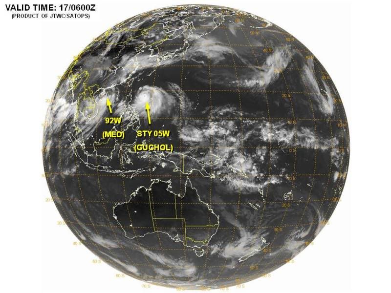
Gaat druk worden in de Indische Oceaan. GFS komt met 3 stormen voor komend weekend. Die bij Mozambique zal de gevaarlijkste worden. Ook ECMWF komt met nog een systeem voor Madagascar op de lange termijn.

Indian Ocean Tropical Cyclone a Threat to Africa
A tropical cyclone taking shape between Mozambique and Madagascar will pose a growing threat of damaging wind and flooding rain this week.
Coastal areas, both of Mozambique and Madagascar, could feel the direct impact of a tropical cyclone landfall between Wednesday and Sunday.
The weather system was already named "Irina" as of Sunday by the Tropical Cyclone Center of Reunion, but the Joint Typhoon Warning Center were not yet referring to it as such.
As of Tuesday, the weather system was merely a tropical low, straddling the coast of northwestern Madagascar, but an environment favorable for cyclone formation lay off shore.
Potential tropical cyclone paths would be towards the south and southwest over the Mozambique Channel.
The speed and extent of storm intensification will hinge upon the system's path, an open-water track favoring substantial strengthening.
Some forecast tools accessed by AccuWeather.com meteorologists indicate that a strong and potentially dangerous storm will take shape at sea late in the week.
This tropical cyclone season in the southwestern Indian Ocean has been busy with costly storm aftermaths in both Madagascar and Mozambique.
Both Funso and Giovanna were intense tropical cyclones having serious wind and rain impacts.
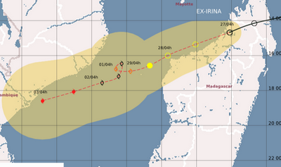
Tropische storm IRINA staat op de kaart en heeft een windveld van 64 km/u, waarbij windstoten voorkomen tot 80 km/u. Er zit nu weinig beweging in de storm. Met een gangetje van 1.5 km/u trekt Irina door het kanaal van Mozambique richting het zuiden. Volgens de verwachting zal de storm toenemen tot orkaankracht, waarbij de piekwind zal oplopen tot rond de 140 km/u. Maar zoals vaak gebeurd kan de verwachting nog bijgesteld worden. De temperatuur van het water ligt hier boven de 30 graden.


Irina is nog steeds een tropische storm, maar is wel in kracht toegenomen. De windsnelheid ligt nu op 112 km/u, waarbij windstoten voorkomen tot 136 km/u. De nieuwe update laat zien dat de storm snel orkaankracht zal halen en over 24 uur al op een categorie 2 zit. Het is afwachten of dit ook daadwerkelijk gaat gebeuren, soms wordt de koers en kracht van een orkaan ineens geheel anders.
Madagascar heeft nu het meest last van Irina. Het eiland ligt al een aantal dagen onder een dik pak bewolking, waardoor veel neerslag valt. Veel berichten hoor je nooit uit dergelijke landen, maar waarschijnlijk heeft het eiland te maken met de nodige overstromingen e.d.
Irina zal uiteindelijk landfall maken in Mozambique, maar ook Zuid Afrika kan overlast krijgen door neerslag.
quote:Irina flood threat to Southeast Africa
Irena has unleashed gusty winds and heavy rainfall to parts of Mozambique, South Africa and Madagascar this week.
As of Sunday, EST, the center of Tropical Cyclone Irina (14S) was near 27.6 south and 34.1 east, or about 120 miles southeast of Maputo, Mozambique. Movement was to the south at 10 mph. Maximum sustained winds were near 45 mph with gusts to 55 mph.
Current satellite shows only scattered convection around the center of the system which continues to limit the intensity of the system.
Tropical Cyclone Irina will move in a southerly direction over the next 24 hours. Irina is expected to remain off the southern Mozambique and northern South Africa coast during this time. This will bring wind and rounds of locally heavy rain to the coast; however, given that the storm is so small, impacts will be limited to coastal areas.
A trough crossing the southern part of the continent will attempt to pull Irina to the southeast as it moves nearby, but it is expected to miss this connection and return back to the north and west making landfall on Wednesday or Wednesday night in southern Mozambique as a minimal cyclone.
Given this expected track, coastal wind damage and flooding problems are expected from northeast South Africa into southern Mozambique through the middle of the week.
Tropical Storm SIXTEEN
Ten zuiden van de Cocoseilanden is een een nieuwe tropische storm ontstaan. Dit systeem zal nog in kracht toenemen tot een cat 1. Voorlopig lijkt het erop dat er geen bedreiging zal zijn voor landen.
Het systeem koerst met een snelheid van ongeveer 20 km zuidwaarts en is nu te vergelijken met een windkracht 8, waarbij windstoten voorkomen tot boven de 80 km/u.
Ten zuiden van de Cocoseilanden is een een nieuwe tropische storm ontstaan. Dit systeem zal nog in kracht toenemen tot een cat 1. Voorlopig lijkt het erop dat er geen bedreiging zal zijn voor landen.

Het systeem koerst met een snelheid van ongeveer 20 km zuidwaarts en is nu te vergelijken met een windkracht 8, waarbij windstoten voorkomen tot boven de 80 km/u.

Dodental op Madagascar is 72 en 70.000 daklozen. Irina is de dodelijkste storm van 2012 tot nu toe.
[quote]Heavy rains from Tropical Cyclone Irina have killed 72 people on Madagascar and left 70,000 homeless, according to news reports. Irina never reached hurricane strength, but dumped heavy rains on the island over an extended period, February 29 - March 2. The area affected was remote, so the reports of the disaster only today reached the outside world. Irina is the deadliest tropical cyclone of 2012 thus far, and the second deadly storm to affect the island in recent weeks; Tropical Cyclone Giovanna hit the island two weeks ago as a Category 3 storm, killing 35 and leaving 240,000 homeless. Irina is expected to dissipate over cold waters southwest of Madagascar over the next day.
bron


LUA gaat nog verder in kracht toenemen en zal als categorie 2 landfall maken in de buurt van Port Hedland (12.000 inwoners).
De storm is nu te vergelijken met een windkracht 9 met uitschieters tot 120 km/uur. De kerndruk ligt op 981mb.
Bij een categorie 2 hoort een stormvloed van 1,5 tot 2,5 meter boven normaal
De storm is nu te vergelijken met een windkracht 9 met uitschieters tot 120 km/uur. De kerndruk ligt op 981mb.
Bij een categorie 2 hoort een stormvloed van 1,5 tot 2,5 meter boven normaal

LUA is in kracht toegenomen tot een orkaan van de 1e categorie. Met een kerndruk van 970mb en een windsnelheid van 120 km/u, (waarbij windstoten voorkomen boven de 155 km/uur) trekt de orkaan verder richting land.
Een orkaanwaarschuwing is uitgegeven in het kustgebied van Bidyadanga tot Mardie, waar de plaatsen Port Hedland, Karratha Dampier zich ook bevinden.
Volgens de laatste update komt de orkaan vlakbij Port Hedland aan land met een hoogste windsnelheid van 148 km/u met uitschieters tot 185 km/u.
De treksnelheid ligt nu rond de 9 km/u, maar die zal langzaam wat toenemen tot ongeveer 30 km/u net voor landfall.
Moment van Landfall op zaterdag 17 maart
Ook na het aan land gaan van de orkaan, zal er nog veel overlast komen. Het systeem trekt verder over West Australie en zorgt nog steeds voor stormachtig weer met zeer veel neerslag.
zondag 18 maart met nog een windkracht 8 en veel neerslag
Een orkaanwaarschuwing is uitgegeven in het kustgebied van Bidyadanga tot Mardie, waar de plaatsen Port Hedland, Karratha Dampier zich ook bevinden.
Volgens de laatste update komt de orkaan vlakbij Port Hedland aan land met een hoogste windsnelheid van 148 km/u met uitschieters tot 185 km/u.
De treksnelheid ligt nu rond de 9 km/u, maar die zal langzaam wat toenemen tot ongeveer 30 km/u net voor landfall.
Moment van Landfall op zaterdag 17 maart

Ook na het aan land gaan van de orkaan, zal er nog veel overlast komen. Het systeem trekt verder over West Australie en zorgt nog steeds voor stormachtig weer met zeer veel neerslag.
zondag 18 maart met nog een windkracht 8 en veel neerslag


quote:Tropische storm en minitornado vernielen Townsville
Een tropische storm heeft in het noorden van Australië lelijk huisgehouden in het stadje Townsville. De mini-wervelstorm, die snelheden haalde van meer dan 110 km/u, vernielde in de vroege ochtend een zestigtal gebouwen. Dertien mensen raakten gewond. De storm rukte tientallen daken van de huizen, knapte stroomleidingen en blies auto's en bomen omver. De stad aan de oostkust van het continent werd tot rampgebied uitgeroepen.
Anna Bligh kwam als premier van de deelstaat Queensland al een kijkje nemen. "Ik ben gechoqueerd door de omvang van de schade. Enkele slachtoffers zullen gedurende maanden niet meer kunnen terugkeren naar hun huis."
"Het hele huis daverde op zijn grondvesten, vooral de bovenste verdieping. Het lawaai was oorverdovend", aldus bewoonster Erin Matinca op televisiezender ABC. Ze werd wakker toen de wind de meubelen in het huis had omvergeworpen. "We moesten in de gang blijven, dat was de enige plaats die veilig was voor rondvliegend vensterglas."
Aanhangwagen paar huizen verder
De ware omvang van de vernieling was pas bij dageraad zichtbaar, vertelde Tony Ebon. De storm had zijn twee ton zware aanhangwagen een paar huizen verder geblazen. Shane Fayers en zijn gezin vluchtten in het toilet van hun woning toen de storm hun huis vernielde. Dak en muren werden weggerukt.
"Het duurde slechts een tiental minuten. Ik kon voelen hoe het huis werd uiteengereten. Dat was redelijk wild", zei Fayers. Soldaten van een nabijgelegen kazerne zijn opgeroepen om mee de schade te helpen opruimen.


quote:Hurricane Season 2012: Below average
A cooler Atlantic Ocean will probably produce 10 named storms in the hurricane season that begins June 1, about half last year’s total, according to researchers at Colorado State University.
Of those systems, four will probably become hurricanes with winds of at least 74 miles (119 kilometers) per hour and two may grow into major storms with winds of 111 mph or more, according to the forecast.
“What we’re expecting right now is a somewhat below- average hurricane season compared to the 1981 to 2010 average,” said Phil Klotzbach, lead author of the forecast begun at the university 29 years ago by Bill Gray, a pioneer in long-range hurricane predictions. “The take-home message with all of our forecasts is that it is kind of our best estimate, but it only takes one storm to make it an active season for you.”
The season, which runs through Nov. 30, is closely watched because the storms are a threat to oil and natural gas interests in the Gulf of Mexico and agriculture in the South. The Gulf accounts for 29 percent of U.S. oil output and 40 percent of refining capacity, while Florida is the second-largest citrus producer behind Brazil.
Last year, Colorado State predicted in April that there would be 16 named storms. Nineteen developed, tying with 2010, 1995 and 1887 for the third-most active season, based on records dating back to 1851.
Weather Patterns
Klotzbach said larger weather patterns will probably have an impact on the number of storms in the Atlantic this year.
The Pacific Ocean may experience an El Nino warming, which will increase wind shear across the Atlantic, he said. Wind shear tears at the structure of hurricanes and can keep weaker systems from growing into larger storms.
The possibility of the Pacific warming to levels needed to create additional Atlantic shear is still uncertain, based on computer models, Klotzbach said.
The models are bad at making predictions about El Nino during the Northern Hemisphere’s spring from March to June, said Mike Halpert, deputy director of the U.S. Climate Prediction Center in Camp Springs, Maryland.
“This is absolutely the worst time of year to try to forecast,” Halpert said.
In addition to the warmth of the Pacific, temperatures at the surface of the Atlantic also play a role in determining how many hurricanes will form, Klotzbach said.
Atlantic Cooling
The Atlantic surface has cooled in part because of the weather pattern that left the eastern U.S. warmer than normal this past winter. A cooler Atlantic, especially off the coast of Africa, means there is less energy for storms to draw on as they develop, Klotzbach said.
The Colorado State outlook is in line with those from commercial forecasters MDA EarthSat Weather in Gaithersburg, Maryland, and Commodity Weather Group LLC in Bethesda, Maryland.
Both companies predicted 11 storms for this year.
The average season produces 12 named systems, six of which become hurricanes with three developing into major storms, according to Dennis Feltgen, spokesman for the National Hurricane Center in Miami.
Irene, which went ashore in North Carolina, New Jersey and New York in August, was the first hurricane to strike the U.S. since Ike hit near Galveston, Texas, in 2008. There hasn’t been a major hurricane landfall since Wilma in 2005, the longest such stretch on record.
A storm gets a name when its winds reach 39 mph. Based on the averages from 1966 to 2009, the first of the season usually occurs by July 9 and the first hurricane by Aug. 10.
De eerste storm met een naam kan al ontstaan in April. Alberto is de eerste naam van dit seizoen.
Een storm in April is zeer bijzonder, want de laatste keer was in 1851.
Een storm in April is zeer bijzonder, want de laatste keer was in 1851.
quote:First named storm in the Atlantic possible next week
Both the GFS and ECMWF models are predicting that an extratropical "cut-off" low will separate from the jet stream early next week several hundred miles east of Bermuda, and linger for several days over subtropical waters with temperatures in the 22 - 24°C range. These ocean temperatures may be warm enough to allow the storm to organize into a named subtropical storm. However, climatology argues against such an occurrence; there has been only one named April storm in the Atlantic since 1851. If a subtropical storm does form next week, it would probably not affect any land areas.
Jeff Masters


quote:Forecast 2012
AccuWeather's 2012 Atlantic Hurricane Season forecasts 12 named tropical storms, five named hurricanes and two major hurricanes.
The 2012 hurricane forecast is near-normal for the Atlantic Basin.
Potential Impact This Year
Predicting exactly where storms will make landfall in the U.S. would be extremely difficult, but there are some indications of areas where storms may brew and coasts that may be vulnerable based on weather patterns anticipated this summer.
"Home-grown" storms in the western Atlantic and Gulf of Mexico, near the U.S. Coast, are a possibility this year.
"Fronts coming down during June and July could cause energy to break off and develop tropically," Paul Pastelok, AccuWeather.com lead long-range forecaster, said.
"Another big storm is possible for the East Coast with heavy, flooding rain," Pastelok added. "With a ridge [of high pressure] over the Rockies and a trough [of low pressure] over the Great Lakes and Appalachians, the East Coast will be open for a hit [this summer]. Of course, this depends on where the storms form."

Nog ver weg. De eerste storm in de Pacific (oost)??
[ Bericht 0% gewijzigd door #ANONIEM op 06-05-2012 22:07:06 ]

[ Bericht 0% gewijzigd door #ANONIEM op 06-05-2012 22:07:06 ]
quote:Signs of tropical activity in Caribbean later this month
While an area is being watched in the Eastern Pacific for tropical development early this week, the Caribbean could show some signs of life later this month.
A broad area of low pressure is expected to form very slowly in the area around Central America and the western Caribbean.
Folks living in the region around Central America to Cuba, Jamaica, The Bahamas and South Florida should not be overly concerned at this point.
Chances are this system will never become strong or well organized.
However, it could spread a swath of downpours over the region. Even a weak, disorganized system can produce clusters of heavy, gusty thunderstorms, which would be a problem for pleasure boaters, beach goers and fishing interests.
According to Tropical Weather Expert Dan Kottlowski, "This is likely to end up like about a dozen or so systems during the season that do not reach tropical storm status."
"The system will not have any tropical waves coming in from the east to give it a jump start, but a non-tropical feature arriving from the northwest next week may just help create a broad area of low pressure or gyre," Kottlowski added.
We are in a neutral phase of the El Nino Southern Oscillation (ENSO). This is the fluctuation of sea surface temperatures in the tropical Pacific Ocean.
When the tropical Pacific surface water is warmer than average, it is considered an El Nino, When it is cooler than average it is considered La Nina.
During an El Nino, (warm water phase) air tends to rise over the tropical Pacific Ocean, supporting the formation of tropical cyclones. Correspondingly, air tends to sink over the Atlantic, working against the formation of tropical cyclones.
It tends to work just the opposite during a La Nina phase of the ENSO.
"Since we are in a neutral phase, we should not expect any substantial interference or gain at this point of the season by the ENSO," Kottlowski said.
The start of the Atlantic hurricane season is not until June 1, but tropical storms have formed as early as January and February with hurricanes as early as March.

80% inmiddels voor de invest daarroquote:Op zondag 6 mei 2012 22:06 schreef aloa het volgende:
Nog ver weg. De eerste storm in de Pacific (oost)??
quote:Azoren low pressure system unlikely to develop
The hybrid low pressure system with both tropical and extratropical characteristics that formed Saturday over the far Eastern Atlantic, about 450 miles southwest of the southern Azores Islands (Invest 92L), has weakened considerably, and is unlikely to become Subtropical Storm Alberto. Wind shear has increased to a very high 25 - 40 knots over 92L today, causing a marked deterioration of the heavy thunderstorm activity. Also not helping is the fact 92L is over cold ocean waters of 68°F (20°C.) This is well below the 26°C usually needed for a tropical storm to form. Satellite estimates of 92L's winds were 35 mph at 7:45 am EDT Monday, according to NOAA/NESDIS. NHC estimated that 92L had top winds of 40 mph at 8 am EDT Monday, down 10 mph from Saturday's peak. Wind shear is expected to remain very high and water temperatures will cool as 92L moves northeast towards the Azores Islands on Tuesday and Wednesday, and the chances of the storm developing into a subtropical or tropical cyclone are near zero percent.

En ook al bij de oostkust...is dit een voorbode van wat nog gaat komen?quote:Op zaterdag 19 mei 2012 23:39 schreef SoldMayor het volgende:
Zo kijk dit dan eens.
[ afbeelding ]
Vroege start dus van het seizoen.
Wie weet.quote:Op zondag 20 mei 2012 09:29 schreef aloa het volgende:
[..]
En ook al bij de oostkust...is dit een voorbode van wat nog gaat komen?
Het begint vroeg en meteen ook opvallend druk.
In de oost pacific nu al storm nummer 2 van het seizoen.
Opvallende koers, en opvallend sterk voor deze tijd. Mogelijk gevaar.
Veder is Alberto wat aan het dolle voor de oost kust van Amerika.
En 03W is er ook al:
In de oost pacific nu al storm nummer 2 van het seizoen.

Opvallende koers, en opvallend sterk voor deze tijd. Mogelijk gevaar.
Veder is Alberto wat aan het dolle voor de oost kust van Amerika.
En 03W is er ook al:

Oost Pacific seizoen begint begin mei dus dat is nog niet zo uitzonderlijk vind ik.
Ziet er wel naar uit dat "Bud" een orkaan wordt
Ziet er wel naar uit dat "Bud" een orkaan wordt
Bud is een 3tje geworden.quote:
Oost Pacific seizoen begint begin mei dus dat is nog niet zo uitzonderlijk vind ik.
Ziet er wel naar uit dat "Bud" een orkaan wordt
Edit: 2 nu.

Tijdens Alberto zat ik in Miami Beach, daar heeft het in de ochtend en begin van de middag toch even flink gewaaid en geregend. In de middag klaarde het ineens heel snel op, binnen 15/20min. was er bijna geen wind meer.quote:Op maandag 28 mei 2012 16:26 schreef devzero het volgende:
Beryl is iets van 150 KM ten oosten van hier en ik merk er niet zo heel veel van.
Orkaanseizoen zal minder actief zijn dan normaal
Het vandaag begonnen orkaanseizoen 2012 in het Noord-Atlantisch gebied zal "minder actief" zijn dan normaal met slechts één tot drie grote orkanen, zo heeft de Amerikaanse weerdienst NOAA voorspeld.
Ondanks de voorspelling dat het orkaanseizoen minder actief zal zijn dan de voorbije jaren, beklemtoont administrateur Jane Lubchenco dat het voor elkeen die in orkaangebieden woont of vakantie neemt, vitaal is zich voor te bereiden.
Zij herinnerde daarbij aan de orkaan Andrew die twintig jaar geleden het zuiden van Florida verwoestte tijdens een seizoen waarin tot op die dag nog maar zes stormen waren ontstaan.
Tot 30 november verwacht de NOAA negen tot vijftien tropische stormen (waarbij de wind de 62 km per uur overschrijdt). Daarvan kunnen er zich vier tot acht ontwikkelen tot orkanen met windsnelheden van minstens 120 km per uur. Eén tot drie kunnen een orkaan van de categorie drie worden, met windsnelheden van meer dan 178 km per uur.
Het gemiddelde van de laatste dertig jaar voor het Noord-Atlantisch gebied is twaalf tropische stormen, zes orkanen en drie zware orkanen, aldus nog de weerdienst.
Bron: HLN
oud nieuws

Carlotta bij de oost pacific is aan het ontploffen. Watertemperatuur is nu ongeveer 29 graden, maar de koers gaat richting water boven de 30 graden.
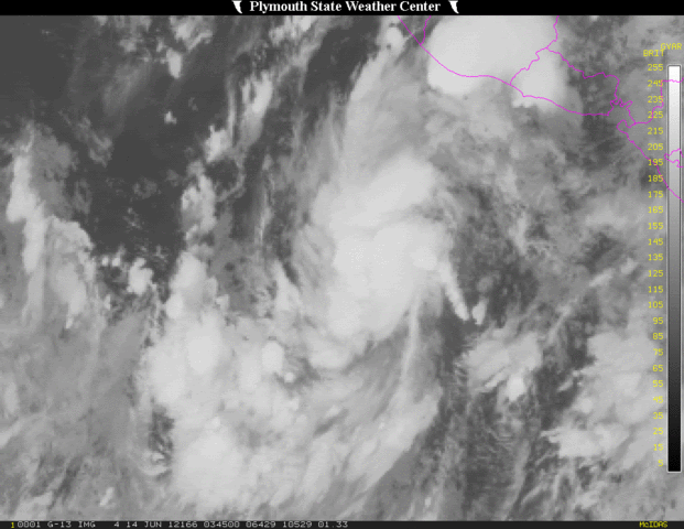


twitter:breakingweather twitterde op donderdag 21-06-2012 om 13:46:27 RT @henry_margusity: We should have a storm in the Gulf of Mexico by the end of the weekend or early next week. reageer retweet
 RT @
RT @
Geloof er niets van. Deze depressie is er "al" een tijdje en er gebeurt niets mee en zal ook weer verdwijnen.quote:twitter:breakingweather twitterde op donderdag 21-06-2012 om 13:46:27 RT @henry_margusity: We should have a storm in the Gulf of Mexico by the end of the weekend or early next week. reageer retweet
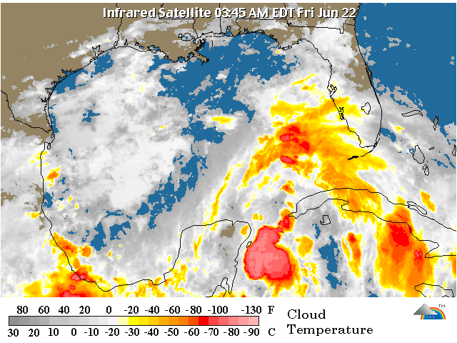
quote:1. A BROAD AREA OF LOW PRESSURE OVER THE SOUTH-CENTRAL GULF OF MEXICO
IS PRODUCING A LARGE AREA OF CLOUDINESS... SHOWERS...AND
THUNDERSTORMS THAT EXTENDS FROM THE NORTHWESTERN CARIBBEAN SEA
NORTHWARD INTO THE SOUTHEASTERN GULF OF MEXICO AND FLORIDA.
STRONG UPPER-LEVEL WINDS OVER THE GULF OF MEXICO ARE EXPECTED TO
DIMINISH IN A DAY OR SO...AND SOME GRADUAL DEVELOPMENT OF THIS
SYSTEM IS POSSIBLE AS THE DISTURBANCE MOVES SLOWLY NORTHWARD TOWARD
THE CENTRAL GULF OF MEXICO. THIS SYSTEM HAS A MEDIUM CHANCE...30
PERCENT...OF BECOMING A TROPICAL CYCLONE DURING THE NEXT 48 HOURS.
REGARDLESS OF DEVELOPMENT...HEAVY RAINS AND LOCALIZED FLOODING ARE
POSSIBLE ACROSS THE YUCATAN PENINSULA...WESTERN CUBA...AND SOUTHERN
FLORIDA THROUGH SATURDAY.