WKN Weer, Klimaat en Natuurrampen
Lees alles over het onstuimige weer op onze planeet, volg orkanen en tornado's, zie hoe vulkanen uitbarsten en hoe Moeder Aarde beeft bij een aardbeving. Alles over de verwoestende kracht van onze planeet en tal van andere natuurverschijnselen.


Welkom! Hier alweer het volgende deel in de reeks Hurricane Season! Alle informatie over het ontstaan van nieuwe orkanen in 2012 vind je hier. En natuurlijk volgen we ze allemaal op de voet! Voor zowel Atlantische, Indische als Pacifische stormen kan je hier terecht
Algemene Info
Met de term 'Hurricane Season' bedoelen we in eerste instantie de periode van 1 juni tot 30 november. Deze periode wordt in de Atlantische Oceaan en de Golf van Mexico gezien als het Atlantische orkaanseizoen. Echter komen deze gewelddadige stormen overal in de wereld voor en met name ook in Azië zorgen ze jaarlijks voor duizenden slachtoffers en tienduizenden daklozen. Daar heten ze Cyclonen of Tyfoons.
In de laatste jaren zijn Tropische Stormen, Orkanen en Cyclonen meer en meer in de media gekomen. Het lijkt ook alsof ze meer en meer slachtoffers maken. Een documentaire over Hurricane Andrew uit 1992, heeft diepe indruk gemaakt en ook zullen kenners orkanen Floyd, Gilbert, Stan en Ivan zich zeker nog herinneren. De catastrofe die "Katrina" met zich meebracht ging de hele wereld over. En dan praten we eigenlijk alleen over de Atlantische stormen en lijken we te vergeten dat er in 2007 meer dan 4000 doden vielen in Bangladesh door orkaan Sidr en orkaan Nargis zorgde voor 80.000 doden in Myanmar alleen al.
Hoewel het Atlantische seizoen pas officieel in juni begint zijn er op andere plekken in de wereld zeker meer orkanen te vinden in de komende maanden. We zullen ook deze dus zeker gaan bespreken. Waarschijnlijk zal de kern van de discussie en de posts gaan over de periode 1 juni tot 30 november. T.z.t. zal er ook wel een NWS-topic worden geopend als een orkaan ook uitgebreid in het nieuws komt.
Orkanen: Hoe ontstaan ze eigenlijk?
Op de site van Wikipedia kan je in het Nederlands nalezen hoe ze ontstaan en wat de belangrijkste energiebron is voor hun verwoestende kracht: het warme zeewater

Ook de BBC heeft er een interessante en leuke animatie over gemaakt.
Ook wordt er op LiveScience in het engels prima uitgelegd hoe ze ontstaan en zich ontwikkelen
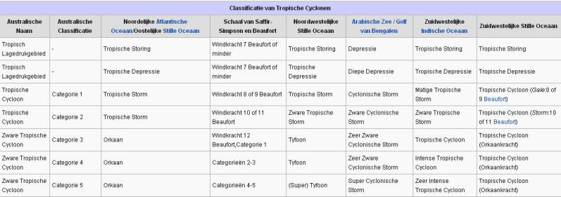
Indeling, Kracht en Stormvloed
De stormen worden ingedeeld op 'categorie'. Vaak zijn het eerst tropische stormen" (Tropical Depression, Tropical Storms), die overgaan tot Orkaanstatus (Hurricanes/Tyfoons) Ze worden ingedeeld op windsnelheden via de Saffir-Simpson Schaal.
Door de enorme windkracht van een orkaan wordt het zeewater opgestuwd. Dit zeewater wordt als het ware vooruit geblazen, voor de storm uit. Hoe zwaarder de orkaan des te meer zeewater vooruit wordt geduwd. De stormvloed wordt dan ook gemeten bovenop de reguliere golfslag. Je kan het enigszins vergelijken met een muur van water (tsunami) die vooruit wordt geduwd.
Tropische Depressie: windsnelheden van 38 tot 61 km/u
Tropische Storm: windsnelheden van 62 tot 118 km/u
Orkaan 1e categorie: windsnelheden van 119 tot 153 km/u en een stormvloed van 1 tot 1,5 meter boven normaal
Orkaan 2e categorie: windsnelheden van 154 tot 177 km/u en een stormvloed van 1,5 tot 2,5 meter boven normaal
Orkaan 3e categorie: windsnelhden van 178 tot 209 km/u en een stormvloed van 2,5 tot 3,7 meter boven normaal
Orkaan 4e categorie: windsnelheden van 210-249 km/u en een stormvloed van 3,8 tot 5,5 meter boven normaal
Orkaan 5e categorie: windsnelheden > 250 km/u en een stormvloed van meer dan 5,5 meter boven normaal
Onderstaand schema geeft de kracht en benaming van orkanen overal ter wereld weer
TIP: Interactief (film)overzicht van de krachten van orkanen n.a.v. de schaal van Simpson
Waarom hebben orkanen namen?
De Tropische Depressies worden overal ter wereld in de gaten gehouden en zodra de depressies uitgroeien tot orkaan of cycloon, wordt er een naam aan de storm gegeven. Sinds 1950 krijgen ze namen op alfabetische volgorde (met uitzondering van de letters Q, U, X, Y en Z). Mocht een orkaan vernietigend hebben huisgehouden zoals Floyd, Gilbert en bijv. Katrina, dan zal die naam worden vervangen. Soms komt het ook voor dat alle letters van het alfabet gebruikt zijn in één seizoen (zoals 2005), dan zal een volgende storm Alpha gaan heten, gevolgd door Beta etc etc. Voor het orkanenseizoen 2012 zijn de namen als volgt:
Atlantische Stormen 2012
Alberto, Beryl, Chris, Debby, Ernesto, Florence, Gordon, Helene, Isaac, Joyce, Kirk, Leslie, Michael, Nadine, Oscal, Patty, Rafael, Sandy, Tony, Valerie, William
In het Noordoosten van de Pacific ontstaan ook orkanen. Deze orkanen zorgen vaak voor overlast in Midden-Amerika en delen van Mexico.
Oost Pacifische Stormen 2012
Aletta, Bud, Carlotta, Daniel, Emilia, Fabio, Gilma, Hector, Ileana, John, Kristy, Lane, Miriam, Norman, Olivia, Paul, Rosa, Sergio, Tara, Vicenta, Willa, Xavier, Yolanda, Zeke
Verder zijn er dan nog de stormen in het Noordwesten, Midden en Zuiden van de Pacific. Daar worden ze tyfoons en/of cyclonen genoemd. Vooral de stormen in het Noord/Westen komen vaak in het nieuws omdat ze Japan, de Filipijnen, Taiwan en China vaak teisteren, maar ook geheel Zuid Oost Azië kunnen treffen. Ook in de Indische oceaan komen ze voor, daar zijn vaak Bangladesh en Myanmar aan de beurt, maar soms ook India, Pakistan of zelfs Oman.
Meer informatie over de namen van orkanen vind je hier.
Leuk hoor allemaal, maar wanneer zijn die orkaanseizoenen nou precies?
ATLANTISCHE OCEAAN: 1 juni t/m 30 november, met pieken eind augustus en september
NOORD OOST PACIFIC:Begin mei t/m begin november, met piek in augustus/september
NOORD WEST PACIFIC: Begin juli t/m eind november, maar eigenlijk hele jaar door activiteit.
NOORD INDISCHE OCEAAN: april t/m december met pieken in mei en november
ZUID INDISCHE + WEST AUSTRALISCHE OCEAAN: oktober t/m mei met pieken in februari en april
ZUID WEST PACIFIC + OOST AUSTRALISCHE OCEAAN: oktober tot eind april met piek in februari.
Over het algemeen is Mei de rustigste maand en September de zwaarste.
En? Zijn er al verwachtingen en/of voorspellingen voor 2012?
In december 2011 zijn de eerste lange termijn verwachtingen naar buiten gekomen. TSR (Tropical Storm Risk) kwam met een ietwat boven gemiddeld orkaanseizoen. Volgens hen ligt de activiteit van het tropische seizoen 49% boven het meerjarig gemiddelde van 1950-2010 met 14 tropische stormen, 7 orkanen en 3 zware orkanen.
Weather Service International (WSI) kwam eind december met een nagenoeg gemiddeld orkaanseizoen. Een zwakkere LaNina en een koele Noord Atlantische Oscillatie, eentje die al een decennia niet meer voorgekomen is, maken er een gemiddeld seizoen van. 12 tropische stormen, 7 orkanen en ook 3 zware orkanen.
In april 2012 zal er een definitieve versie komen van de voorspellingen.
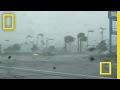
Waait het nou echt zo hard bij zo'n orkaan?
Oude delen van Hurricane Season vind je hier:
Topicreeks: Hurricane Season
Enkele Links en Leesvoer
1. National Hurricane Centre
2. Carribean Storm Network
3. Hurricanezone
4. Hurricane Track
5. Website met satelietbeelden van de Caribbean en de rest van Amerika
6. Intellicast: Geavanceerde satellietfoto's en gifs van aktuele stormen
7. Tropical Weather Underground
8. Tropical Storm Risico's van dit moment
9. Wikipedia Hurricanes/Tyfonen in het algemeen
10. Alle stormen ter wereld van de laatste jaren in overzicht
11. The StormTrack
12. Orkanensite in de Filipijnen
13. Atlantische Orkanensite
14. Actuele orkanen in Australië en De orkaanindeling in Australië
15. Tropische weersite omgeving Australië
16. Mooie site over Orkanen aan de VS kusten
17. Website van NASA over Hurricanes
18. Windrapporten wereldwijd
19. Storm2k - Amerikaans weerforum
Opmerkelijke Wikipedia-Links
-- Hurricane Katrina 2005
-- Cyclone Nargis 2008
-- Hurricane Season 2012 - Wikipedia
-- Hurricane Season 2011 - Wikipedia
-- Hurricane Season 2010 - Wikipedia
-- Hurricane Season 2009 - Wikipedia
-- Hurricane Season 2008 - Wikipedia
-- Hurricane Season 2007 - Wikipedia
-- Hurricane Season 2006 - Wikipedia
-- Hurricane Season 2005 - Wikipedia
-- Hurricane Season 2004 - Wikipedia
Actuele Weerradar in Golf van Mexico

Actuele Water temperatuur.


Madagascar Facing Cyclone Threat
Tropical low pressure has formed in the Mozambique Channel, where it could become an important tropical cyclone before potentially crossing the shores of western Madagascar Sunday or Monday.
Already, as of Saturday, locally heavy rain has pelted both sides of the channel, mostly in the northern halves of Madagascar and Mozambique, this week. Likewise, the Comoros Islands have been dosed.
Satellite imagery on Saturday has shown deep convective rains reaching well northwest into Africa, likely along the southern edge of the regional Monsoon. This stream seems to have been feeding the gathering low.
On Friday, the Joint Typhoon Warning Center (JTWC) plotted the center of low pressure within 50 to 100 miles of central Mozambique. Now, as of Saturday afternoon, local time, the low's center seems to be over the middle of the southern Mozambique Channel, drifting southeastward.
Landfall in Madagascar looks set to happen near, if not between, Morombe and Morondava, Madagascar.
A slower forward speed could favor a stronger storm, as sea surface temperature in the likely path of this low is about 29 degrees C as of early Friday.
Barring explosive deepening to a storm of hurricane intensity, the greatest hazard stemming from this tropical weather system will be that of flash flooding. I believe that western Madagascar north the low's path, together with southeastern Madagascar, will be at greatest risk of excessive rain and serious flooding through the middle of next week.
Historically, Madagascar has suffered serious flash flooding during its summer rainy season, especially in the drier, scrubby western side of this huge island. A rough estimate is that highest falls of rain will be between 8 and 16 inches (200 and 400 mm) through the first half of the week.


quote:Cyclone warning issued for parts of Western Australia
A cyclone warning has been issued for parts of Western Australia's Pilbara coast.
The Bureau of Meteorology says a tropical low was located about 550 kilometres north of Port Hedland at 2:00pm (WST) and is moving south at around 20 kilometres per hour towards the coast.
The bureau says a cyclone may develop later on Wednesday and a warning is current for coastal areas from Wallal to Dampier, including the towns of Port Hedland and Karratha.
The Tropical Cyclone Warning Centre's Adam Conroy says heavy rains and gale force winds are expected.
"The low's going to bring a fair bit of rain to the central and eastern Pilbara and we're also looking at gale force winds developing on the coast during Wednesday," he said.
"We certainly will see a fair few falls in excess of 100 millimetres and isolated heavier falls are possible near the coast."
Mr Conroy says the low is moving quite quickly.
"The low's developed reasonably rapidly off the coast," he said.
"Regardless of whether it does develop into a cyclone or not, it's still going to bring some heavy rainfall and squally conditions along the Pilbara coast during Wednesday."
Heavy rain in the Pilbara has already forced the closure of two national parks.
The Karijini National Park received 97 millimetres of rain overnight while the Millstream Chichester National Park recorded 125 millimetres.
The rain has caused flash flooding and inundation of roads and campsites in the parks.
The Department of Environment and Conservation (DEC) says there is significant danger associated with flash flooding and gorges because water levels can rise very high, quickly.
The DEC is advising travellers to avoid the parks and stick to major roads.
People already in the parks are advised to stay with their vehicles and move to higher ground but not to cross floodways and streams.
Authorities are telling people to be prepared to leave if the situation worsens.
The DEC says with more rain forecast, the parks will remain closed under further notice.
quote:Cyclone Heide moving in
A category one cyclone has formed off Western Australia and is heading towards the Pilbara coast.
The Bureau of Meteorology says Tropical Cyclone Heidi is expected to produce winds of up to 100 kilometres per hour in areas from Port Headland to Wallal early this morning.
The strong gales will extend west to Dampier later in the day.
The weather bureau says Heidi is unlikely to intensify beyond a category one system before reaching the coast.
It says tides will be higher than expected and rainfall in excess of 100 millimetres is possible across the central and eastern Pilbara, with heavier falls near the coast.
People in or near coastal and island communities between Pardoo and Whim Creek, including Pardoo, Port Hedland, South Hedland and Whim Creek, need to begin making their cyclone preparations.

Heidi is nu vergelijkbaar met een storm (kracht 9) en zal waarschijnlijk nog intensiveren (kracht 10/11) voordat deze aan land komt. Er wordt 250 mm aan neerslag verwacht, wat voor overstromingen kan gaan zorgen.
quote:Tropical Cyclone Heidi intensifies as it nears West Australian coast
THE alert level has been raised for a category 1 tropical cyclone off the West Australian Pilbara coast, as it increases in intensity and is likely to become a category 2 before it hits land.
A yellow alert has been issued for people between the coastal and island communities of Pardoo and Whim Creek, including the communities of Port Hedland and South Hedland, and residents have been warned to get ready to take shelter.
A blue alert remains in place for surrounding areas, including Roebourne, Port Sampson, Karratha and Dampier, and residents have been warned to prepare food and a first aid kit.
The weather bureau says Tropical Cyclone Heidi is estimated to be 185km north, north-east of Port Hedland and moving south at 15km/h towards the coast.
It is moving in a southerly direction towards the Pilbara coast, and could produce gusts to 100km/h in coastal areas, extending west during the afternoon.
The cyclone is expected to become a category 2 during the evening and is expected to cross the coast of Port Hedland overnight at 155km/h, the bureau says.
The Port Hedland Airport has been closed and some flights have been cancelled.
Port Hedland Port Authority spokesman Steed Farrell told AAP the port had activated its cyclone contingency plan at 4pm (WST) on Tuesday in preparation for the wild weather.
''We cleared inbound traffic into the port and cleared the port of vessels that needed to get out,'' he said.
Mr Farrell said the port would wait for word from the weather bureau before resuming operations.
The weather bureau says very heavy rainfall is expected later on tonight and overnight in the river catchments between Port Hedland and Karratha.
Up to 250mm of rain is possible across central and eastern Pilbara over the next few days with isolated heavier falls near the coast, the bureau says.
Residents in and near Port Hedland and east to Wallal have been warned of the potential of a dangerous storm tide as the cyclone centre crosses the coast overnight.
Tides are likely to rise above the normal high-tide mark with very rough seas and flooding of low-lying coastal areas, the weather bureau says.
Tides elsewhere in the Pilbara should also be higher than normal.
Tropical Cyclone Heidi is the second cyclone of the season for the WA region, but is the first to affect the mainland.
It is the first to affect Port Hedland since severely devastating tropical cyclone George in 2007.

Check de druk..daalt gestaag door de laatste uren, terwijl de windsnelheden snel stijgen
http://www.bom.gov.au/products/IDW60801/IDW60801.94310.shtml
quote:Cycloon Heidi treft West-Australië
Het westen van Australië is getroffen door de tropische cycloon Heidi. Door de storm is de haven van Port Hedland noodgedwongen gesloten; het is een van de grootste ijzeropslagplaatsen in de wereld. Andere havens in de buurt zijn ook gesloten.
Een paar duizend gezinnen en bedrijven in de regio hebben geen stroom meer. Ook moest een aantal kustbewoners hun huis uit vanwege de hoge waterstand die door de cycloon werd veroorzaakt.
Er is nog niets bekend over mogelijke slachtoffers. Heidi trekt de komende dagen verder over land richting het zuidwesten van Australië.
quote:Tropical Cyclone Heidi soaks North West
You won't find a more cyclone hardened part of Australia, if not the world, than Western Australia's Pilbara Region. It's like a magnet for cyclones that form in the Indian Ocean to the north and West and in the Timor Sea to the Northeast. So you might think that category two cyclone Heidi that passed almost over the top of the tough iron ore town of Port Hedland would barely rate a mention. But surprisingly, this was Hedland's first cyclone since 2007 when Severe Tropical Cyclone George hit the region where it hurts, taking three lives in a mining workers camp.
Less well known than the big east coast cyclones Larry and Yasi, category 4 George tore through Port Hedland before ripping up mining camps and cattle stations. So there were more nerves than usual in the North West as Cyclone Heidi crossed the coast at almost the exact spot the deadly Cyclone George did five years ago.
Hedland resident and ABC reporter Elise Batchelor, described the strange affects the 130 kilometre per hour wind gusts were having on her home
"The manhole cover in our...ceiling...It was flapping like a wobble board Rolf Harris style and then just flew up and disappeared into the ceiling."
Power was cut to over 3,500 homes as the eye of Cyclone Heidi crossed the coast ten kilometres east of Port Hedland. Fears of a dangerous storm-tide did not eventuate as the cyclone slowed on approach to the mainland and crossed after the midnight high tides. But with over a hundred millimetres of rain dumped on the area, local flooding was an issue.
The Bureau of Meteorology issued flood warnings for coastal streams and river systems. Chris, a boilermaker at Nallagine said they've had over 200 millimetres of rain.
"It's rained solid for 28 hours now...There's like, huge puddles everywhere; there's not much dry land here." he said.
But early assessments have found no major damage, a couple of roofs were blown off and quite a few trees and power lines were blown down. The stoicism and hardiness of the region returned with the light of day and the realisation that damage was minimal.
"We're getting a fare bit of rain, but as long as the winds don't pick up then I think we should be pretty much right" said Graham Boyd, the principal at Yandeyarra Remote Community School, 100 kilometres south of Hedland.
The Great Northern Highway was closed for less than 24 hours to stop people driving into the eye of the storm. But with the passing of Heidi, the main road north was promptly reopened.
Chainsaws will be ringing out across what will be hot and humid days ahead in Port Hedland. Horizon Power have crews working to restore power. Heidi is destined to become a barely remembered event in a part of Australia where cyclones are a way of life.

quote:Possible tropical threat to Mozambique
An area of low pressure spinning over Indian Ocean waters off the coast of southern Africa threatens to bring torrential rain inland during upcoming days.
In fact, the low has the potential to become a tropical cyclone before reaching land.
Time for development is short, however, as the system is forecast to move into southern Mozambique on Monday.
Whether the disturbance becomes a tropical cyclone or not, it can bring rain heavy enough to trigger flooding in Mozambique's southern provinces, primarily Maputo, Inhambane and Gaza, beginning later Sunday night.
The risk of heavy rain will persist in the aforementioned areas through midweek while expanding into neighboring areas of Swaziland, northeastern South Africa and southeastern Zimbabwe. In areas of steep terrain, especially in northeastern South Africa, there can be mudslides.
Should the low grow into a tropical cyclone, there would be strong and locally damaging winds along the coast of southern Mozambique on Monday.

Lijkt een zware orkaan te gaan worden bij Mozambique/Madagascar. Gfs laat dit systeem dagenlang rondtollen tussen beide landen, wat voor veel neerslag, overstromingen etc kan zorgen.
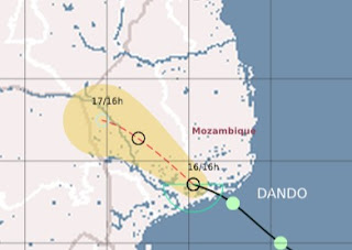
quote:Tropical Depression Dando Flooded Mozambique
NASA's Terra satellite captured a look at Tropical Depression Dando as it was making landfall on January 16 in Mozambique. Dando's light to moderate rains caused flooding and displaced residents of the capital city of Maputo. Dando has since dissipated.
NASA's Terra satellite passed over Dando on January 16, 2012 at 07:50 UTC (2:50 a.m. EST). The Moderate Resolution Imaging Spectroradiometer (MODIS) Instrument aboard Terra captured a visible image of the storm, and showed that it had good circulation with an identifiable center of circulation. The bulk of clouds and rainfall associated with Dando at that time was within its southern quadrant, as the clouds appeared thicker and whiter on satellite imagery.
According to the Associated Press, almost 500 people were displaced from their homes in Maputo from the flooding generated from Tropical Depression Dando. Dando made landfall on January 16, 2012 bringing light to moderate rainfall and gusty winds. The rainfall may not have been heavy but it was enough to cause the closure of low-lying bridges and roads. All Africa.com reported on January 18 that areas of Mozambique are flooded.
Gusty winds from Dando caused damage to schools and homes in the Inhambane and Gaza provinces. Fortunately, there were no human deaths associated with the storm, however, AllAfrica.com reports as many as 1,000 goats perished in the Gaza province. Agricultural damages were also reported there.

Tropical storm Eight
Tropical Storm EIGHT ligt tussen het vasteland van Afrika en Madagascar in en heeft een windveld van 64 km/uur met windstoten tot 80 km/uur. Deze storm (vergelijkbaar met een windkracht 8 nu) beweegt zeer traag (8 km/uur) waardoor er zeer veel neerslag kan gaan vallen. Vooral in Mozambique kan dit voor overstromingen gaan zorgen. GFS laat dit systeem uitgroeien tot een zware orkaan, wat ook mogelijk is (watertemperatuur +30 graden en weinig shear). Dit systeem heeft een grotere kans om te groeien tot een cat2 of meer, dan tropische storm Ethel. Ethel zakt verder naar het zuiden, waar de watertemperaturen lager liggen en hier is ook meer shear dan bij tropische storm Eight.
Tropical Storm ETHEL
Tropical storm Ethel kan een bedreiging vormen voor het eilandje Rodrigues. Volgens verwachting zal deze orkaan het eilandje als tropische storm rakelings passeren, waarbij veel neerslag zal vallen. Het windveld zit nu op 80 km/uur (windkracht 9) met windstoten tot 104 km/uur.
Tropical Storm EIGHT ligt tussen het vasteland van Afrika en Madagascar in en heeft een windveld van 64 km/uur met windstoten tot 80 km/uur. Deze storm (vergelijkbaar met een windkracht 8 nu) beweegt zeer traag (8 km/uur) waardoor er zeer veel neerslag kan gaan vallen. Vooral in Mozambique kan dit voor overstromingen gaan zorgen. GFS laat dit systeem uitgroeien tot een zware orkaan, wat ook mogelijk is (watertemperatuur +30 graden en weinig shear). Dit systeem heeft een grotere kans om te groeien tot een cat2 of meer, dan tropische storm Ethel. Ethel zakt verder naar het zuiden, waar de watertemperaturen lager liggen en hier is ook meer shear dan bij tropische storm Eight.

Tropical Storm ETHEL
Tropical storm Ethel kan een bedreiging vormen voor het eilandje Rodrigues. Volgens verwachting zal deze orkaan het eilandje als tropische storm rakelings passeren, waarbij veel neerslag zal vallen. Het windveld zit nu op 80 km/uur (windkracht 9) met windstoten tot 104 km/uur.

quote:Flooding hits Kruger Park South Africa
Torrential rain unleashed by a dissipating tropical depression triggered flooding in northeastern South Africa this week.
After causing flood and wind damage in and near Maputo, Mozambique, early in the week, the dissipating Tropical Depression Dando poured flooding rain over nearby South Africa, including the vast Kruger National Park.
Weather observations seen by AccuWeather.com showed rainfall of nearly 15 inches at Hoedspruit, and about 11 inches at Skukuza. The rain fell between Tuesday and Thursday. Skukuza is located within Kruger Park.


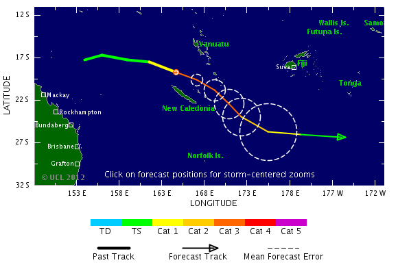
Nieuw systeem bij Australie. Tropical Cyclone Iggy
[ Bericht 6% gewijzigd door #ANONIEM op 25-01-2012 20:13:04 ]

[ Bericht 6% gewijzigd door #ANONIEM op 25-01-2012 20:13:04 ]

GFS laat hem meer richting land trekken inderdaad.quote:Op vrijdag 27 januari 2012 14:16 schreef Frutsel het volgende:
'Iggy' lijkt ietwat meer langs de kust te trekken dan gisteren of vergis ik mij?

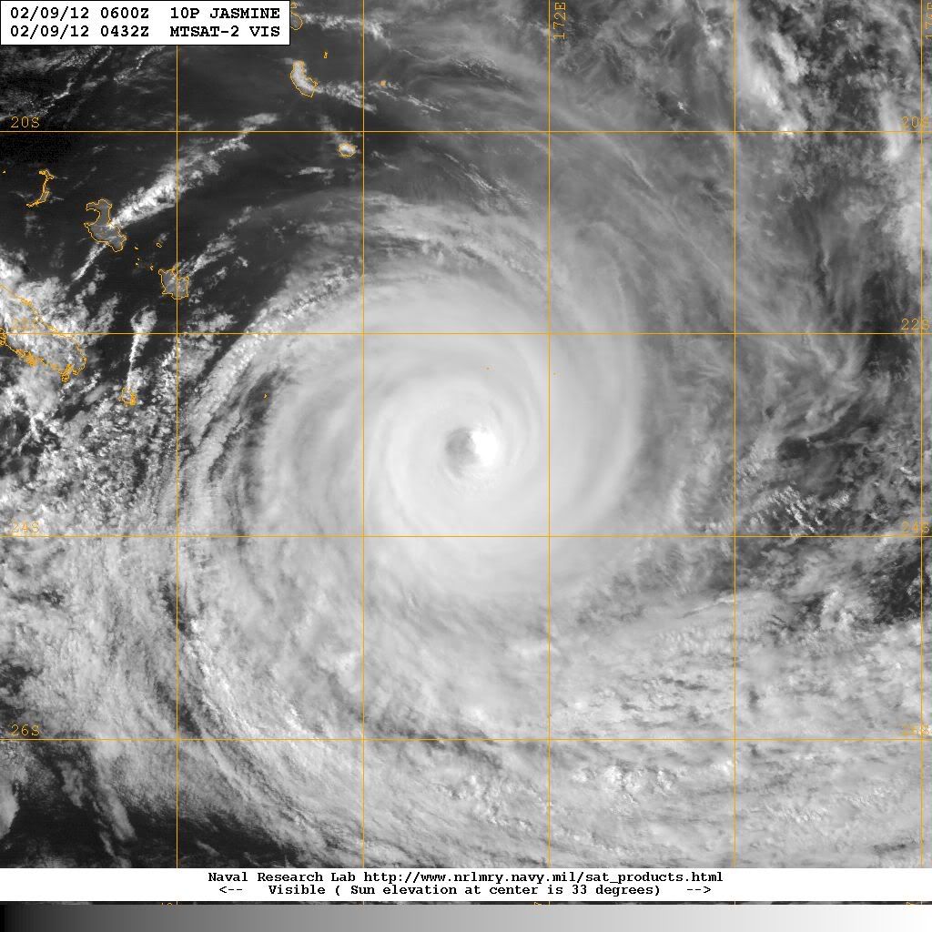
quote:IGGY leaves 16 dead in Indonesia
At least 16 people were confirmed killed and more than 2,300 houses damaged in torrential rains and strong winds that lashed much of Indonesia over the past few days.
Sutopo Purwo Nugroho, a spokesman for the National Disaster Mitigation Agency (BNPB), said on Sunday that most of those killed were struck by trees felled by severe winds.
“Fourteen people were crushed by falling trees,” the spokesman said. “In total, 60 people were injured.”
He added that more than 2,300 houses in 35 districts and cities across Java and Bali had been damaged in the last four days due to heavy winds and rain whipped up by Tropical Cyclone Iggy, churning just south of Bali and the Nusa Tenggara island chain.
“But now Tropical Cyclone Iggy has weakened and is moving away from Indonesia,” he said.
Elsewhere in the country, at least two other people were confirmed killed as a result of the foul weather.
In Bali, the heavy rains caused a massive landslide on Saturday in the Taman Ayun Temple area, a popular tourist spot, killing an 18-month-old baby.
Ketut Parwa, the head of the Bali Search and Rescue Agency, said the child had been asleep with her mother at a food stall in the temple’s parking lot when the disaster struck at 11 p.m. They had gone to the food stall to take shelter from the rain.
Parwa said the 12-meter-high precipice on which the food stall was located suddenly gave way, burying the child in tons of mud. The mother managed to escape. Rescuers recovered the child’s body on Sunday evening.
In Lebak district, Banten, authorities recovered the body of a boy who had been swept away and drowned in a river. They are continuing their search for a friend who was with him.
Irna, an official with the local search team, said the victims, both 14-year-old students at an Islamic boarding school, went missing on Friday while swimming in the rain-swollen Ciberang River. One of the bodies was recovered later that day and given to the family for burial.
“We’ve combed a four-kilometer stretch of the river over the past two days, but we still haven’t been able to find the second boy,” Irna said.
“We’re having great difficulty in our search because of the strong current in the river.”
Nasa's hurricane pagequote:SO INDIAN OCEAN - We're watching another low near Madagascar, now that Funso fizzled. This low is near 16.8S 44.2E, 210 nm northwest of ANTANANARIVO, MADAGASCAR. The low-level center is partially exposed, and its grazing the coast of Cape Saint Andre Region and is moving back into the warm Mozambique Channel. It has a medium chance for becoming a tropical depression.
Maar goed dat die cycloon van de kust wegtrekt...
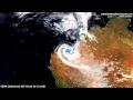
Evacuaties vanwege overstromingen in noordoosten van Australië
Ze kunnen geen 2e Yasi gebruiken daar nu
Evacuaties vanwege overstromingen in noordoosten van Australië
Ze kunnen geen 2e Yasi gebruiken daar nu


Dat zou wat zijn zeg... subtropische storm in februari daarroquote:Tropics Trying to Come Alive in the Gulf of Mexico
The calendar says it's early February, but that is not stopping the tropics from trying to come alive in the south-central Gulf of Mexico.
The area of concern is a cluster of showers and thunderstorms spinning in the southern Gulf of Mexico, near the Yucatan Peninsula.
This broad area of low pressure has not only put the AccuWeather.com Hurricane Center on alert, but prompted the National Hurricane Center in Miami, Fla., to state, "this area is being closely monitored for possible further development."
Tropical season in the Atlantic Basin is not confined to the months spanning June to November, but rather when the conditions are conducive.
Some of those key ingredients needed for the development of at least a subtropical depression (a system with partial tropical characteristics) are currently trying to come together in the south-central Gulf of Mexico.
Water temperatures in the south-central Gulf of Mexico are near 80 degrees, the threshold for tropical development.
While not absent, the wind shear (disruptive winds high in the atmosphere) present is not strong enough to totally inhibit development.
If a subtropical depression or storm were to take shape (acquiring the name "Alberto" from the 2012 list), the AccuWeather.com Hurricane Center feels it would track into South Florida later Monday into Monday night.
Torrential rain causing flooding in low-lying and poor-drainage areas would be the main concern, even if development fails to take place.
Evident by the radar from Key West, Fla., downpours will continue to get pushed into South Florida well ahead of the actual low's center.
The formation of a tropical storm in February is rare, but has occurred once before in history. The Groundhog Day Tropical Storm from 1952 developed in the northwestern Caribbean before tracking across South Florida.


Zal wel een puinhoop worden in Madagascar.quote:
Aloa bedankt
Cat 4 orkaan nadert Madagascar
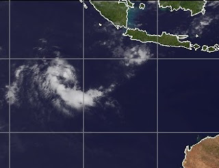
Die andere krul bij Indonesie is deze invest. Of het wat gaat worden is afwachten.


Het zou trouwens zeer zeldzaam zijn als een orkaan vanaf de 90e breedtegraad helemaal weet te overleven tot aan Madagascar.
Ze kunnen het soms lang volhouden. Maar de meeste zakken dan weer richting het zuiden en verdwijnen.quote:
Het zou trouwens zeer zeldzaam zijn als een orkaan vanaf de 90e breedtegraad helemaal weet te overleven tot aan Madagascar.
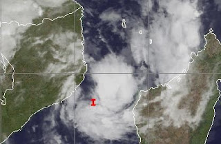
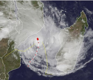
Tropische storm voor Madagascar
Na Giovanna, waarbij meer dan 30 mensen zijn omgekomen en 250.000 mensen dakloos zijn geworden, staat Madagascar weer een nieuwe storm te wachten. Het systeem ligt nu aan de oostkant van het eiland en zal over de noordkant van het eiland trekken, waarna het zich verder lijkt te ontwikkelen in het kanaal van Mozambique. Madagascar en Mozambique krijgen hierdoor te maken met zeer veel neerslag wat overstromingen e.d. kan veroorzaken.
Volgens GFS ligt het systeem op dinsdag tussen Madagascar en Mozambique en zal daar, net als Giovanna enkele dagen rond blijven tollen. Op onderstaande kaartje is nog een ander systeem te zien ten oosten van Madagascar, maar het lijkt erop dat deze niet voor veel problemen gaat zorgen. Deze gaat wel een hogere categorie worden.
Na Giovanna, waarbij meer dan 30 mensen zijn omgekomen en 250.000 mensen dakloos zijn geworden, staat Madagascar weer een nieuwe storm te wachten. Het systeem ligt nu aan de oostkant van het eiland en zal over de noordkant van het eiland trekken, waarna het zich verder lijkt te ontwikkelen in het kanaal van Mozambique. Madagascar en Mozambique krijgen hierdoor te maken met zeer veel neerslag wat overstromingen e.d. kan veroorzaken.

Volgens GFS ligt het systeem op dinsdag tussen Madagascar en Mozambique en zal daar, net als Giovanna enkele dagen rond blijven tollen. Op onderstaande kaartje is nog een ander systeem te zien ten oosten van Madagascar, maar het lijkt erop dat deze niet voor veel problemen gaat zorgen. Deze gaat wel een hogere categorie worden.
