WKN Weer, Klimaat en Natuurrampen
Lees alles over het onstuimige weer op onze planeet, volg orkanen en tornado's, zie hoe vulkanen uitbarsten en hoe Moeder Aarde beeft bij een aardbeving. Alles over de verwoestende kracht van onze planeet en tal van andere natuurverschijnselen.


Update 02/10 22:12 UTC : After a period of relative calm the stronger earthquakes started again around Sunday noon (UTC). We have observed 18 volcanic earthquakes of equal or more of Magnitude 2. The strongest one measured 3.7 ML. 5 earthquakes exceeded ML 3.0. NO change in the depth of the hypocenters. The Canary Island authorities have no real news, they just stated that the "Yellow Alert" is maintained. This situation can go on for many days even many weeks. Earthquake-report.com will keep an eye on what happens and will report it in this article if something significant develops.
[ Bericht 6% gewijzigd door blids op 03-10-2011 14:15:45 ]

[ Bericht 6% gewijzigd door blids op 03-10-2011 14:15:45 ]
En waarop baseren ze dat dan?quote:Op zondag 2 oktober 2011 23:12 schreef Keiichi het volgende:
De aardbevingen die er zijn, lijken in zuidelijke richting te trekken.
-edit-
Er zijn trouwens wel een hoop mensen die denken dat El Hierror net zo'n landslide kan veroorzaken als ze denken dat op La Palma zou gebeuren
Inorbit: zeg dat dan typluie triangeljosti
Beauregard: Een beetje FOK!ker laat het brood door z'n moeder smeren.
Ecosia
ek's 'n flash drive, jy's 'n floppy
Beauregard: Een beetje FOK!ker laat het brood door z'n moeder smeren.
Ecosia
ek's 'n flash drive, jy's 'n floppy
Verleden misschien?quote:
[breaking] Vulkaanuitbarsting op Canarische Eilanden op komst?
Al vaker aardverschuivingen geweest daar. Ook met tsunami
quote:2011-10-03 10:54:15.31hr 32min ago 27.64 N 18.07 W 17 2.8 CANARY ISLANDS, SPAIN REGION
2011-10-03 10:27:49.61hr 58min ago 27.63 N 18.07 W 14 2.7 CANARY ISLANDS, SPAIN REGION
2011-10-03 10:14:43.42hr 12min ago 27.63 N 18.08 W 15 3.4 CANARY ISLANDS, SPAIN REGION
Nee helaas. Ik ben overledenquote:
 Op
Op Mijn Spaans is bar slecht, dus de pers volgen levert niet veel op. Al is het natuurlijk ook zo dat ALS er iets groots zou gebeuren, dat ook wel groots in het nieuws komt. Niets van dat al.
29 graden, cocktails, zon, palmen, strand. Geen aardbevingen
Acquisitie n.a.v. deze post wordt niet op prijs gesteld.
Don't you see going to heaven is just in the thought that you might?
As an on-line radio program grows longer, the probability of a German song approaches 1.
Don't you see going to heaven is just in the thought that you might?
As an on-line radio program grows longer, the probability of a German song approaches 1.
Magma on the move in El Hierro, Canary Islands
Update 3 October 2011
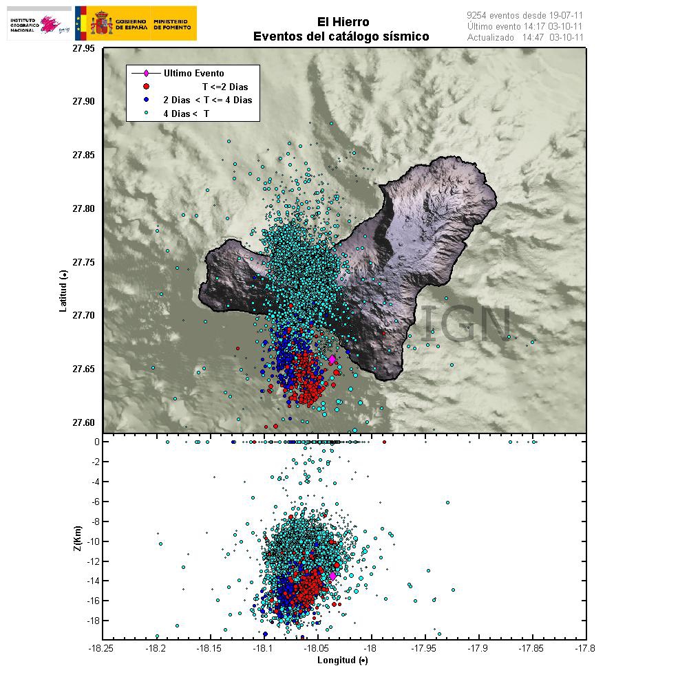
This is happening faster then I expected. But it seems that magma is now on the move upwards in El Hierro volcano in Canary Islands. This is evident by the earthquake patterns that are emerging from the volcano. Given the earthquake locations, most likely place for a eruption to take place is out on the ocean based on that. But sometimes magma can find different pathways up the surface without a lot of warning.
Latest earthquake map from Instituto Geográfico Nacional that shows clearly the earthquake pattern since the dike intrusion did start in El Hierro. Copyright of this picture belongs to Instituto Geográfico Nacional.
At the moment it is impossible to know when and where a eruption might start. It depends on many factors. But it is now clear that magma is on the move upwards. So far the magma seems to be around 10 km up in the earth crust under El Hierro. So it is clear that the magma is on the way up and most likely preparing for a eruption.
[ Bericht 0% gewijzigd door blids op 03-10-2011 20:38:40 ]
Update 3 October 2011
This is happening faster then I expected. But it seems that magma is now on the move upwards in El Hierro volcano in Canary Islands. This is evident by the earthquake patterns that are emerging from the volcano. Given the earthquake locations, most likely place for a eruption to take place is out on the ocean based on that. But sometimes magma can find different pathways up the surface without a lot of warning.
Latest earthquake map from Instituto Geográfico Nacional that shows clearly the earthquake pattern since the dike intrusion did start in El Hierro. Copyright of this picture belongs to Instituto Geográfico Nacional.
At the moment it is impossible to know when and where a eruption might start. It depends on many factors. But it is now clear that magma is on the move upwards. So far the magma seems to be around 10 km up in the earth crust under El Hierro. So it is clear that the magma is on the way up and most likely preparing for a eruption.
[ Bericht 0% gewijzigd door blids op 03-10-2011 20:38:40 ]
dat met tsunami haal ik er niet uit. Alleen dat er heel veel materiaalt de zee in schuift...quote:
[..]
Verleden misschien?
[breaking] Vulkaanuitbarsting op Canarische Eilanden op komst?
Al vaker aardverschuivingen geweest daar. Ook met tsunami
[..]
Inorbit: zeg dat dan typluie triangeljosti
Beauregard: Een beetje FOK!ker laat het brood door z'n moeder smeren.
Ecosia
ek's 'n flash drive, jy's 'n floppy
Beauregard: Een beetje FOK!ker laat het brood door z'n moeder smeren.
Ecosia
ek's 'n flash drive, jy's 'n floppy
Wanneer er veel materiaal de zee in zou schuiven heb je natuurlijk wel een tsunami te pakken. De vraag is dan alleen hoeveel volume verplaatst zou worden.quote:Op dinsdag 4 oktober 2011 07:03 schreef Jumparound het volgende:
[..]
dat met tsunami haal ik er niet uit. Alleen dat er heel veel materiaalt de zee in schuift...
Ik heb wel een andere vraag in een stukje hierboven staat dat de magma aan het bewegen is. Maar zitten er dan zulke grote open ruimtes in vulkanen dat daar de magma zo doorheen kan stromen?
Dat is onzin, de vraag is niet hoveel, maar HOE het materiaal de zee in schuift.quote:
[..]
Wanneer er veel materiaal de zee in zou schuiven heb je natuurlijk wel een tsunami te pakken. De vraag is dan alleen hoeveel volume verplaatst zou worden.
Ik heb wel een andere vraag in een stukje hierboven staat dat de magma aan het bewegen is. Maar zitten er dan zulke grote open ruimtes in vulkanen dat daar de magma zo doorheen kan stromen?
Jou stelling is het zelfde als "een zeebeving veroorzaakt altijd een tsunami" Iets wat niet waar is.
Je moet een bepaalde hoek hebben waaronder een groot volume in zee stort. En het materiaal moet een zekere compacte (?) waarde hebben,Er kan wel 28 km3 puin in zee storten, maar als dat over een aantal weken gebeurd.....
naja, dat bedoel ik dus
Inorbit: zeg dat dan typluie triangeljosti
Beauregard: Een beetje FOK!ker laat het brood door z'n moeder smeren.
Ecosia
ek's 'n flash drive, jy's 'n floppy
Beauregard: Een beetje FOK!ker laat het brood door z'n moeder smeren.
Ecosia
ek's 'n flash drive, jy's 'n floppy
daar lijkt het idd op... maar hoe snel stijgt dat spul? 100 meter per dag? dan hebben we over 100 dagen een uitbarsting ;-)quote:
Inorbit: zeg dat dan typluie triangeljosti
Beauregard: Een beetje FOK!ker laat het brood door z'n moeder smeren.
Ecosia
ek's 'n flash drive, jy's 'n floppy
Beauregard: Een beetje FOK!ker laat het brood door z'n moeder smeren.
Ecosia
ek's 'n flash drive, jy's 'n floppy

Energie stijgt nog steeds. Blijkbaar is grafiekje de druk die naar boven word opgebouwd (zoals Jumparound al zei, thanks nog). Op een ander forum word gezegd dat Mount St. Helens ging bij een druk van tussen de 10 en 16 (dacht ik).
quote:Magma on the move in El Hierro, Canary Islands
This is happening faster then I expected. But it seems that magma is now on the move upwards in El Hierro volcano in Canary Islands. This is evident by the earthquake patterns that are emerging from the volcano. Given the earthquake locations, most likely place for a eruption to take place is out on the ocean based on that. But sometimes magma can find different pathways up the surface without a lot of warning.
Latest earthquake map from Instituto Geográfico Nacional that shows clearly the earthquake pattern since the dike intrusion did start in El Hierro. Copyright of this picture belongs to Instituto Geográfico Nacional.
At the moment it is impossible to know when and where a eruption might start. It depends on many factors. But it is now clear that magma is on the move upwards. So far the magma seems to be around 10 km up in the earth crust under El Hierro. So it is clear that the magma is on the way up and most likely preparing for a eruption.

Volgens mij is het een opsommige van alle aarbeving.quote:
[ afbeelding ]
Energie stijgt nog steeds. Blijkbaar is grafiekje de druk die naar boven word opgebouwd (zoals Jumparound al zei, thanks nog). Op een ander forum word gezegd dat Mount St. Helens ging bij een druk van tussen de 10 en 16 (dacht ik).
Een aardbeving van 2.0 zou gelijk staan aan een energie-release van 63 MJ. Een van 3.0 al aan 360 MJ
http://en.wikipedia.org/wiki/Richter_magnitude_scale
hij telt idd "events" 9400 nu...
lijkt er op dat het een totaal aan vrijgekomen energie is.
hoewel google het vertaald als "totaal opgeslagen energie"
lijkt er op dat het een totaal aan vrijgekomen energie is.
hoewel google het vertaald als "totaal opgeslagen energie"
Inorbit: zeg dat dan typluie triangeljosti
Beauregard: Een beetje FOK!ker laat het brood door z'n moeder smeren.
Ecosia
ek's 'n flash drive, jy's 'n floppy
Beauregard: Een beetje FOK!ker laat het brood door z'n moeder smeren.
Ecosia
ek's 'n flash drive, jy's 'n floppy
Ik heb een docu gezien over die "waarschijnlijke" landslide.quote:
De aardbevingen die er zijn, lijken in zuidelijke richting te trekken.
-edit-
Er zijn trouwens wel een hoop mensen die denken dat El Hierror net zo'n landslide kan veroorzaken als ze denken dat op La Palma zou gebeuren
Zou komen omdat de bodem poreus zou zijn in de zuidelijke helft van la palma.
Die poreusheid is in de loop van de eeuwen gevuld met water. Met een beetje warmte en druk kan het daar breken en de zee in gaan.
Maar ik meen dat alleen La Palma zo poreus was.
<a href="http://goo.gl/q8fhTe" target="_blank">FAQ?</a>
<a href="http://goo.gl/gYvZFq" target="_blank">Geel is een zonnige en vrolijke kleur, als hij tenminste enigszins warm is gekleurd en wat naar het oranje neigt</a>
<a href="http://goo.gl/gYvZFq" target="_blank">Geel is een zonnige en vrolijke kleur, als hij tenminste enigszins warm is gekleurd en wat naar het oranje neigt</a>
quote:35mm deformation at El Hierro
The Instituto Geografico Nacional (IGN) has reported surface deformations exceeding 35mm on the Spanish island of El Hierro, where residents have been alert for a possible volcanic eruption. The number of earthquakes recorded since July 17 on the smallest of The Canary Islands exceeded 9250 on Tuesday morning. IGN confirmed on Monday that 1172 earthquakes were recorded last week, the majority of which were located in the sea to the SW of the 280-sqkm island. 52 of the earthquakes were felt by the local population, estimated to be approximately 10,000. A further 10 earthquakes, exceeding 3.0 magnitude on the Richter Scale, were felt during Monday and early on Tuesday. Hierro, a shield volcano, has had a single historic eruption from the Volcan de Lomo Negro vent in 1793. The eruption lasted approximately one month and produced lava flows. The recent surge in the number and intensity of earthquakes prompted officials from the IGN and The Canary Islands Government to raise the alert level for the Hierro volcano to ‘Yellow’ late last month.
Seismologists say the majority of the earthquake activity has shifted from El Golfo in the island’s northwest to beneath the Las Calmas Sea in the south. However, magma is now on the move upwards while the depth of earthquakes has become increasingly shallow in recent days with most being recorded at a depth of 10 to 14 kilometres. Movement of magma towards the surface signifies that a volcanic eruption is likely to happen, but the timing of such remains unclear. Volcanologist Juan Carlos Carracedo last week suggested that an eruption on El Hierro would “not be a major surprise”. He explained: “It is the youngest of the Canary Islands. There is a ball of magma which is rising to the surface and it is stationed at the limit of the earth’s crust. At the moment we do not know if that ball of magna will break the crust and cause an eruption.” IGN Director, María José Blanco said that any eruption on El Hierro would most likely have a “low explosion value”.
A dramatic rise in recorded earthquakes on El Hierro last Tuesday prompted officials to evacuate some local residents, shut El Hierro’s main tunnel, and close local schools. The Spanish Civil Guard (Guardia Civil) advised almost 50 residents of the municipality of La Frontera to leave their homes because of landslide fears. Two units of the Spanish military’s emergency intervention unit (EMU) were also placed on standby to depart the nearby island of Tenerife to assist in the possible evacuation of hundreds of other El Hierro residents. Meanwhile, the island’s main tunnel (Tunel del Golfo), which links Frontera to Valverde, was shut forcing motorists to travel across the 280-sq-km island via a mountain road. The Cabildo de El Hierro also ordered the closure of schools on Wednesday.
quote:El Hierro scientist:'More worried about earthquakes'
The Scientist in charge of the team studying the seismic activity on the Canary Island of El Hierro, Nemesio Pérez, has told the press how is is more concerned about earthquakes on the tiny island than he is of any Volcano eruption "Usually in the Canaries, they have not been that explosive, just trickles of lava. There are victims when there are earthquakes, which is why I am more concerned about the earthquakes rather than the eventual eruption."
Perez, who is the scientific coordinator of the Canaries Institute of Volcanology (Involcan) continued : "Spain has a seismic alert system comparable to that of a third-world country," he says. "Predicting volcanic activity has three components: tremors, gas emissions and deformations. But in Spain, attention is only paid to the first stage."
He told reporters how any volcanic eruption would not be rare, but the uncertainty stems from the fact that in El Hierro there isn't just one major volcano but around 500 vents on the island. As such, no one can be sure where the lava will flow if there does end up being an eruption.
The problem that this causes is that it is impossible to monitor and cordon off each and evert vent, but each one could still produce potentially fatal toxic fumes.
The Island residents have actually felt around 60 of the 9'000 recorded earthquakes over the past two months, however the frequency and strength has increased over the past two weeks.
Update 02/10 – 22:12 UTC : During a meeting of the Canary Islands government with the Spanish government (Civil Defense) in Madrid earlier this morning was decided that the present "Yellow Alert" status will be maintained.
The meeting also decided that the local government should meet with the scientists of the seismological and volcano agency ING one of the coming days to discuss the risk on landslides, which could be triggered by the seismic activity (the reason for the evacuation).
The evacuated people are eager to return to their houses but the local government and authorities have informed them that the landslide risk is still too high. Yesterday 2 tremors were felt by the locals. The seismic activity goes up and down. Today only 2 tremors have exceeded magnitude 2 (13 hours time). Yesterday, in 24 hours we counted 11 tremors M 2 or more. On October 3 : 34 and on October 2 : 26.
Additionally the tremors, as said earlier, are moving to the south.
(Our) conclusion - it looks good at the moment, but the current conditions should continue for a while before the evacuation will be lifted. The authorities, who are still at the scene with a lot of Civil Defense, Rescue and Aid personnel are not wanting to take any risk. Another good sign is that the deformation remains at 35 mm for many days in a row.
quote:El Hierro Authorities to Educate Residents on Volcano
The Authorities on the tiny island of El Hierro have taken the decision to interact and communicate with the local residents with regards to the situation surrounding the recent earthquake swarms.
The various municipalities, together with the regional government of the Canary Islands, the National Geographic Institute and Volcanic Institute of the Canary Islands, have jointly launched the educational campaign titled " El Hierro : Living with our Volcano "
A half-hour talk will be given to the public entitled "What to do if there is a volcanic eruption" in the Island's main town, Valverde, tomorrow afternoon, which will also run alongside an educational workshop for children titled " Playing with Volcanoes ".
The regional minister for security and emergencies, Maria de Carmen Morales, told the press : "It shows the information we have published in a recent leaflet on volcanic activity, how residents can keep informed of the situation, how to make an emergency plan, and how to act before, during and after an earthquake. These issues will be useful not just now but will help us protect the Island and the residents in the future "
The National Geographic Institute (IGN) confirmed earlier today that a total of 18 earthquakes have now been felt in El Hierro, that have had a magnitude greater or equal to 3.0 on the Richter scale and intensity III and IV.
The lastest count shows 9'342 Earthquakes since the recent swarm began on July 17th, with some 1'128 of them being in the last 7 days.
Read further news stories about the El Hierro Volcano by clicking the link HERE .
<a href="http://goo.gl/q8fhTe" target="_blank">FAQ?</a>
<a href="http://goo.gl/gYvZFq" target="_blank">Geel is een zonnige en vrolijke kleur, als hij tenminste enigszins warm is gekleurd en wat naar het oranje neigt</a>
<a href="http://goo.gl/gYvZFq" target="_blank">Geel is een zonnige en vrolijke kleur, als hij tenminste enigszins warm is gekleurd en wat naar het oranje neigt</a>
Op http://www.avcan.org is veel actuele info te vinden. oa. de sysmografische data in realtime (F5 voor verversen)
[ Bericht 0% gewijzigd door bwt op 08-10-2011 14:09:22 ]
[ Bericht 0% gewijzigd door bwt op 08-10-2011 14:09:22 ]
<a href="http://goo.gl/q8fhTe" target="_blank">FAQ?</a>
<a href="http://goo.gl/gYvZFq" target="_blank">Geel is een zonnige en vrolijke kleur, als hij tenminste enigszins warm is gekleurd en wat naar het oranje neigt</a>
<a href="http://goo.gl/gYvZFq" target="_blank">Geel is een zonnige en vrolijke kleur, als hij tenminste enigszins warm is gekleurd en wat naar het oranje neigt</a>
Zeker toeval dat ze het nu publiceren of staat er in de nabije toekomst iets te gebeuren?quote:Vulkaanuitbarsting Tenerife helpt aardverschuivingen te begrijpen
AMSTERDAM - De ontdekking van een grote vulkaanuitbarsting op Tenerife van 733.000 jaar geleden werpt nieuw licht op aardverschuivingen. Zo is men in de toekomst mogelijk beter voorbereid op de gevolgen van dit soort grote catastrofes.
Vulkanologen van de Universiteit van Leicester ontdekten op het Canarische eiland Tenerife een aardverschuiving ten gevolge van een grote vulkaanuitbarsting waarbij een deel van de zijkant van de vulkaan de zee in verdween.
Ze publiceerden hun bevindingen in de oktober-editie van het tijdschrift Geology.
Bijzonder
Het is bijzonder dat niet vrijwel de hele aardverschuiving door de uitbarsting de zee in verdwenen is. "Het is een van de best bewaarde en toegankelijke voorbeelden van zo’n ontzagwekkend fenomeen, omdat het puin van zulke aardverschuivingen zich meestal over de oceaanbodem verspreid en daardoor ontoegankelijk voor verdere studie", verklaart Dr. Branney, een van de onderzoekers.
Het achtergebleven puin en gruis op Tenerife bevat onder andere blokken van snel afgekoeld stollingsgesteente. Radioactieve mineralen in de gestolde lava maakten het voor de onderzoekers makkelijk om zeer precies de datum van de uitbarsting te bepalen.
Klimaatverandering
Klimaatverandering wordt vaak aangewezen als reden voor aardverschuivingen op eilanden in de oceaan. Dat was nu niet het geval. Een groeiende koepel van hete lava duwde van binnenuit de zijkant van de vulkaan naar buiten toe.
Zulke gebeurtenissen zijn niet ongewoon, maar komen zeer onregelmatig voor. Ze begrijpen is daarom van belang omdat de effecten duizenden kilometers verderop grote problemen kunnen veroorzaken.
Verre van rustig....quote:2011-10-06 12:27:35.131min ago 27.67 N 18.04 W 13 3.1 CANARY ISLANDS, SPAIN REGION
2011-10-06 10:47:31.92hr 11min ago 27.69 N 18.04 W 14 2.8 CANARY ISLANDS, SPAIN REGION
2011-10-06 10:38:24.52hr 21min ago 27.67 N 18.04 W 12 2.5 CANARY ISLANDS, SPAIN REGION
2011-10-06 10:35:53.02hr 23min ago 27.66 N 18.02 W 14 2.7 CANARY ISLANDS, SPAIN REGION
2011-10-06 10:30:10.72hr 29min ago 27.68 N 18.03 W 16 2.5 CANARY ISLANDS, SPAIN REGION
2011-10-06 10:28:05.02hr 31min ago 27.67 N 18.03 W 12 2.6 CANARY ISLANDS, SPAIN REGION
2011-10-06 10:24:34.72hr 34min ago 27.69 N 18.03 W 16 2.5 CANARY ISLANDS, SPAIN REGION
2011-10-06 10:21:02.02hr 38min ago 27.69 N 18.02 W 16 2.5 CANARY ISLANDS, SPAIN REGION
2011-10-06 10:16:11.02hr 43min ago 27.68 N 18.03 W 16 2.6 CANARY ISLANDS, SPAIN REGION
2011-10-06 06:34:04.36hr 25min ago 27.69 N 18.05 W 13 2.6 CANARY ISLANDS, SPAIN REGION
2011-10-06 05:43:12.37hr 16min ago 27.69 N 18.04 W 12 2.8 CANARY ISLANDS, SPAIN REGION
2011-10-06 05:03:17.07hr 56min ago 27.67 N 18.04 W 12 3.2 CANARY ISLANDS, SPAIN REGION
is ook erg goed te zien op de seismogr. data van mijn vorige post.
<a href="http://goo.gl/q8fhTe" target="_blank">FAQ?</a>
<a href="http://goo.gl/gYvZFq" target="_blank">Geel is een zonnige en vrolijke kleur, als hij tenminste enigszins warm is gekleurd en wat naar het oranje neigt</a>
<a href="http://goo.gl/gYvZFq" target="_blank">Geel is een zonnige en vrolijke kleur, als hij tenminste enigszins warm is gekleurd en wat naar het oranje neigt</a>
True... Happy Hour tussen tien en elfquote:
is ook erg goed te zien op de seismogr. data van mijn vorige post.

veel events weer de laatste 2 dagen (als ik die grafiek hierboven bekijk)
Inorbit: zeg dat dan typluie triangeljosti
Beauregard: Een beetje FOK!ker laat het brood door z'n moeder smeren.
Ecosia
ek's 'n flash drive, jy's 'n floppy
Beauregard: Een beetje FOK!ker laat het brood door z'n moeder smeren.
Ecosia
ek's 'n flash drive, jy's 'n floppy
quote:Earthquake activity on El Hierro intensifies
The Instituto Geografico Nacional (IGN) has reported an increase in the intensity of earthquakes recorded on El Hierro, the smallest of The Canary Islands, during the last 24 to 36 hours. The number of earthquakes recorded since July 17 , 2011 on El Hierros has now reached 10,000, figures from the IGN confirm.
The IGN also confirmed surface deformations exceeding 35mm on the 280-sqkm island, where residents have been put on alert for a possible volcanic eruption. However, seismologists have moved to reassure the local population that a volcanic eruption is not imminent.
The agency confirmed on Friday that 890 earthquakes, most of them located in the sea to the SW of the island, have been recorded in the 7 days since 01 October, 2011. During this period, 76 earthquakes were felt by the island’s estimated 10,000 residents.
Since Friday morning, there have been 14 earthquakes exceeding 3.0 on the Richter Scale with epicentres both North and South of the NW Ridge and depths between 10 and 15 km have been recorded. The strongest of the tremors measured 3.8 magnitude on the Richter Scale. A total of 17 earthquakes were felt by the local population.
Hierro, a shield volcano, has had a single historic eruption from the Volcan de Lomo Negro vent in 1793. The eruption lasted approximately one month and produced lava flows.
The recent surge in the number and intensity of earthquakes prompted officials from the IGN and The Canary Islands Government to raise the alert level for the Hierro volcano to ‘Yellow’ late last month. The alert remained in place on Saturday.
Seismologists say the majority of the earthquake activity has shifted from El Golfo in the island’s northwest to beneath the Las Calmas Sea in the south.
However, magma is now on the move upwards while the depth of earthquakes has become increasingly shallow in recent days with most being recorded at a depth of 9 to 14 kilometres. Movement of magma towards the surface signifies that a volcanic eruption is likely to happen, but the timing of such remains unclear.
Volcanologist Juan Carlos Carracedo last week suggested that an eruption on El Hierro would “not be a major surprise”. He explained: “It is the youngest of the Canary Islands. There is a ball of magma which is rising to the surface and it is stationed at the limit of the earth’s crust. At the moment we do not know if that ball of magna will break the crust and cause an eruption.”
IGN Director, María José Blanco said that any eruption on El Hierro would most likely have a “low explosion value”.
quote:Strongest quake so far hits El Hierro
Update 08/10 – 22:15 UTC : Tonight at 20:34 UTC, the strongest earthquake so far has occurred below El Hierro at a depth of 10 km (data EMSC). The earthquake had a magnitude of 4.3!
IGN data
2011/10/08 20:34:48.28 depth 12.5 km Magnitude 4.30
Following IGN , the epicenter was approx. 600 meter out of the coast.
Following IGN the earthquake was felt as an intensity MMI III earthquake (weak shaking).
Earthquake-Report.com is convinced that the return of the evacuated people to their villages might be postponed for some time after this moderate volcanic earthquake. The evacuation took place after the authorities had to act because of landslide risk which could have been triggered by the quakes.
At the other hand the number of earthquakes of M 2 or higher has decreased substantially today as their were only 4 since the last 20 hours.
Update 07/10 – 23:30 UTC : The 2 strongest earthquakes today had a magnitude of 3.7 and 3.8 at a hypocenter depth in between 12 and 16 km. They occurred at 11:27 and 22:29 UTC. Normally this kind of earthquakes are felt by humans.
quote:During the night 17 earthquakes, 9 of them less than 10 km deep. to prof. 2, 3, 2, 2, 1, 2, 2, 1 and 1
die 4.3 heeft de grafiek een aardig zetje gegeven!
Inorbit: zeg dat dan typluie triangeljosti
Beauregard: Een beetje FOK!ker laat het brood door z'n moeder smeren.
Ecosia
ek's 'n flash drive, jy's 'n floppy
Beauregard: Een beetje FOK!ker laat het brood door z'n moeder smeren.
Ecosia
ek's 'n flash drive, jy's 'n floppy
Graag de hierbron en daarbronquote:
Ik lees hier en daar dat ze verwachten dat hij vandaag 'poef' doet? Iemand daar meer kijk op?
De hier en daar bron is een forum vol met conspiracy theorieen, waar ze dit ding dus ook in de gaten houdenquote:
[..]
Graag de hierbron en daarbronkunnen we meekijken.
Zie nu ook dit: http://www.washingtonpost(...)IQAhk2TXL_story.html.
De regering had al even een waarschuwing uitgegeven volgens mij.
Kan iemand de seismogram voor mij verklaren van vandaag?
Kan iemand de seismogram voor mij verklaren van vandaag?
het stromen van Lava?quote:
Kan iemand de seismogram voor mij verklaren van vandaag?
ziet er wel raar uit idd.
| Wordfeud: marcel-o |plug.dj/uptempo |<-- draai zelf je platen
overvliegende vliegtuigen ;-)quote:
http://www.avcan.org/inde(...)ha=10-10-2011&tipo=1
eh?
Wat een ruis! Of iets anders?
Inorbit: zeg dat dan typluie triangeljosti
Beauregard: Een beetje FOK!ker laat het brood door z'n moeder smeren.
Ecosia
ek's 'n flash drive, jy's 'n floppy
Beauregard: Een beetje FOK!ker laat het brood door z'n moeder smeren.
Ecosia
ek's 'n flash drive, jy's 'n floppy
quote:The volcanologists warned a possible volcanic tremor early this morning from El Hierro
Canary Island volcanological Association, through its website on Facebook (Current Volcanic Canary Avcan), has publicly called the National Geographic Institute (about 9:30 hours) "to confirm or disprove the existence of the signal and make an interpretation of the current situation. "Avcan the social network said: "This morning, from 4:18 pm. Or so there has been registering at the station of El Hierro CHIE what could be a sign of volcanic tremor."
The association notes that those tremors are typical "of active volcanoes and indicate magma movement," while begging the public to remain "very calm and avoid unnecessary alarm", since "if it is confirmed that the signal we see at the station CHIE of El Hierro is a tremor, would be within the predictability in the process that is lived on the island since last July. "
Avcan current situation recalls the yellow light to monitor the seismic crisis of El Hierro, insists on asking "a lot of courage and peace" and stressed that "people should be aware of submissions from civil protection authorities."
http://www.elmundo.es/elmundo/2011/10/10/espana/1318242424.html?a=48a515f5cd318b68def0e1d31f458e5b&t=1318242654&numero=
Op 1200 meter diepte,op 7 kilometer van de kust van El Hierro schijnt er een onderzeese uitbarsting te zijn geweest............
Op 1200 meter diepte,op 7 kilometer van de kust van El Hierro schijnt er een onderzeese uitbarsting te zijn geweest............
Crazy as Always...met vleugels natuurlijk..;-0
http://www.hollandsenieuw(...)-op-el-hierro_33363/
Ik weet niet of dit al gepost is maar dit is ook wel een goed blog om bij te houden.
Ik weet niet of dit al gepost is maar dit is ook wel een goed blog om bij te houden.
@Zenkelly
Thx,was persconferentie denk ik rond 1200 uur? Heb Google Translate er ff op gezet
Thx,was persconferentie denk ik rond 1200 uur? Heb Google Translate er ff op gezet
quote:Submarine eruption occuring at El hierro
Seismic monitoring services have been a small submarine eruption at 1,200 meters deep at sea seven miles from El Hierro.
The phenomenon is ongoing and has occurred at 10.43 (local time) in the sea calms and has been a sudden change in the seismic process, as it has paralyzed for weeks tremors felt in the Canary Islands, as reported by experts to Canary Autonomic Radio.
As reported Canarias7, four ships have been alert to the maritime authorities of the existence of volcanic activity south of La Restinga and about 500 meters deep.
This same media reports that emergency services have issued instructions to all diving clubs of El Hierro to suspend any dive on its shores, which are among the most appreciated by fans of the sport because of its biological richness funds.
The first since 1971
If confirmed, this eruption was the first of which is recorded in Spain since 1971, when it emerged Teneguía volcano on the island of La Palma, Canary Islands too.
The eruption may have started this morning on the southern coast of the island, the least populated.
From 11.00 hours (local time) is met in Valverde, the capital of El Hierro, the monitoring group for this type of crisis set by the Civil Protection Special Plan and Emergency Response for Volcanic Risk (Pevolca) de Canarias.
Following that meeting, the authorities are expected to offer a press conference to report on the details of what happened and security measures will be taken on the island.
Earthquake of 4.3
El Hierro has suffered since mid-July around 9600 earthquakes caused by magma activity in the basement of the island.
Just today the eruption takes place two days after he recorded an earthquake of 4.3 magnitude on the Richter scale. This figure made him the most intense earthquake recorded by the National Geographic Institute (IGN) since last July 17, when earthquakes began on the island.
The earthquake, which was felt throughout the island, caused no injury, but caused landslides on the outer slopes of the tunnels and on the road Roquille linking Tacorón to La Restinga, in the southern municipality of El Pinar.
In the first week of October, the IGN has located 890 earthquakes, most of them situated in the sea, southwest of the island.
Yellow alert
The situation remains yellow alert, so that the sequence of earthquakes senses falls within the normal range.
From the July 17 IGN has registered and located nearly 10,000 earthquakes, with epicenters both north and south of the NW ridge and depths between 10 and 15 km. The number of events felt by the population is 133, with intensities II, III and IV in the scale EMS 98.

Thx!quote:
http://www.hollandsenieuw(...)-op-el-hierro_33363/
Ik weet niet of dit al gepost is maar dit is ook wel een goed blog om bij te houden.
Er wordt dus een nieuw Canarisch eiland gevormd, dat over x aantal jaren boven zee zal uitstekenquote:
@Zenkelly
Thx,was persconferentie denk ik rond 1200 uur? Heb Google Translate er ff op gezet
[..]
[b] Op zondag 14 november 2010 18:11 schreef liesje1979 het volgende:[/b]
Zo is daar Godshand, met zijn sarcastische toon,
Die regelmatig een topic voorziet van spot en hoon.
Zo is daar Godshand, met zijn sarcastische toon,
Die regelmatig een topic voorziet van spot en hoon.
Mwa, eerder een pukkeltje net ten zuiden van Hierro, waarna deze twee uiteindelijk zullen samensmelten. Er is al een flinke richel onder water daar.
Berichten spreken elkaar nu weer tegen lees ik 

Ze zijn er nu niet meer zeker van of er wel een uitbarsting gaande is
20.00 uur meer info, nieuwe bijeenkomst
[ Bericht 5% gewijzigd door Frutsel op 10-10-2011 16:56:10 ]
Ze zijn er nu niet meer zeker van of er wel een uitbarsting gaande is
20.00 uur meer info, nieuwe bijeenkomst
[ Bericht 5% gewijzigd door Frutsel op 10-10-2011 16:56:10 ]
Als er geen uitbarsting gaande is dan is er de hele dag al heel wat drukopbouw.
Dan is het wachten tot er een hele grote boem komt.
Met al die bevingen zou je toch denken dat er heel wat stroomt - door een uitbarsting of via de lava kanalen onder/door het eiland.
@frutsel
[ Bericht 39% gewijzigd door bwt op 10-10-2011 17:02:08 ]
Dan is het wachten tot er een hele grote boem komt.
Met al die bevingen zou je toch denken dat er heel wat stroomt - door een uitbarsting of via de lava kanalen onder/door het eiland.
@frutsel
quote:The address PEVOLCA says there is no certainty of an underwater volcanic eruption on the island of El Hierro
10/10/2011 ... 14:06 - Ministry of Economy, Finance and Security
IGN has confirmed early this morning for a small release of fluids and volcanic gases that do not pose such risk to the population
The National Geographic Institute (IGN), official organ for volcano monitoring has confirmed this morning at the direction of the Civil Protection Plan Volcanic Risk (PEVOLCA), although there is no certainty that it is now producing a volcanic eruption submarine, from early this morning has been a release of fluids and volcanic gases of type on the southern coast of the island
IGN scientists have informed the direction of the Plan that all indicators point to have examined the possibility of the onset of an eruptive process as it has changed the type of wave recorded by seismographs in the last hours, which means the beginning of lava emission or abroad.
In this sense, it is purely volcanic signals were not observed until now although it would have to confirm this trend with other parameters such as pressure, gas release or deformation of the ground, among others.
The Helicopter Emergency and Rescue Group of the Canary Islands (GES) has conducted reconnaissance flights in the morning without looking out of volcanic material to the surface.
Although this activity does not pose a risk to the population, the Directorate of PEVOLCA recommends that people perform their regular duties normally and remain alert to any unusual activity.
At the end of the meeting held this morning in Valverde was determined that this afternoon, starting at 19 hours, the Plan address the latest analysis report scientists conducting IGN.
[ Bericht 39% gewijzigd door bwt op 10-10-2011 17:02:08 ]
<a href="http://goo.gl/q8fhTe" target="_blank">FAQ?</a>
<a href="http://goo.gl/gYvZFq" target="_blank">Geel is een zonnige en vrolijke kleur, als hij tenminste enigszins warm is gekleurd en wat naar het oranje neigt</a>
<a href="http://goo.gl/gYvZFq" target="_blank">Geel is een zonnige en vrolijke kleur, als hij tenminste enigszins warm is gekleurd en wat naar het oranje neigt</a>
Dit schijnt inmiddels weer tegengesproken te zijnquote:IGN has confirmed early this morning for a small release of fluids and volcanic gases that do not pose such risk to the population
Hopelijk snel duidelijkheid wat er nu aan de hand is.
Er komen inmiddels ook weer meer twitter berichten van de officiele kant
quote:The volcanologists Avcan qualify the situation as "confusing" and ask the National Geographic Institute to confirm the eruption
The Association Volcano Islands (Avcan), through its website Facebook, 'Current Volcanic Islands', described on Monday the current situation in El Hierro "confused" by not being able to confirm the actual existence on the surface of a preerupción submarine on the coast near El Hierro despite the visual and thermal studies carried out by the helicopter area of the Institute of the Canary Islands Volcano (non-tip).
For this reason, ask the National Geographic Institute to rule and say "what is really happening." Also, on its website bemoaned the lack of a research vessel in this crisis, because "we could confirm the current situation."
Moreover, they indicate that the behavior of the evolution of the depth of seismicity prior to the onset of tremor signal is "less weird", so that they could not say for sure that what is happening right now is a small eruption underwater although "both the president of the Cabildo de El Hierro Frontera and the mayor spoke of a possible volcanic eruption, to be confirmed, but almost certainly".
<a href="http://goo.gl/q8fhTe" target="_blank">FAQ?</a>
<a href="http://goo.gl/gYvZFq" target="_blank">Geel is een zonnige en vrolijke kleur, als hij tenminste enigszins warm is gekleurd en wat naar het oranje neigt</a>
<a href="http://goo.gl/gYvZFq" target="_blank">Geel is een zonnige en vrolijke kleur, als hij tenminste enigszins warm is gekleurd en wat naar het oranje neigt</a>
Intussen lijkt de Tremor steeds krachtiger te worden:
http://www.avcan.org/inde(...)ha=10-10-2011&tipo=1
http://www.avcan.org/inde(...)ha=10-10-2011&tipo=1
quote:Aanwijzingen voor vulkaanuitbarsting Canarisch Eiland
In de omgeving van het Canarisch Eiland El Hierro is mogelijk een vulkaanuitbarsting begonnen. Het Spaanse persagentschap EFE meldde vandaag onder aanhaling van experten dat volgens de jongste computergegevens op een diepte van 2.000 meter onder de zeebodem ten zuiden van El Hierro een eruptie aan de gang is. Volgens de Canarische radio zijn alle duikclubs op het eiland verwittigd hun activiteiten in het water te staken.
Op het kleinste van de Canarische Eilanden zijn sinds juli ongeveer 9.600 zwakke aardschokken geregistreerd. Ze gelden als een voorteken op een vulkaanuitbarsting. De zwaarste aardbeving deed zich zaterdagavond voor met een kracht van 4,3 op de schaal van Richter. Sinds weken heerst er op het eiland de alarmfase geel, waardoor de zowat 10.000 bewoners op een mogelijke evacuatie moeten voorbereid zijn. (dpa/dea)
Dumdumdum
Ben zeer benieuwd naar het resultaat...
Ben zeer benieuwd naar het resultaat...
Alexa en Seth zijn lief
See everything; overlook a great deal; correct a little
See everything; overlook a great deal; correct a little
http://www.lanzarote-guide.com/en/volcanoes mooi verslag van een priester die een uitbarsting op Lanzarote meemaakte.
Heftig!
Hopelijk blijft de uitbarsting bij El Hierrro beperkt tot de zee.
Heftig!
Hopelijk blijft de uitbarsting bij El Hierrro beperkt tot de zee.
Jéétjuh, wat is het heftig aan het worden...het is nu 20.00 geweest: ben benieuwd..ook of dit de trigger is voor meer!!quote:
Intussen lijkt de Tremor steeds krachtiger te worden:
http://www.avcan.org/inde(...)ha=10-10-2011&tipo=1
Crazy as Always...met vleugels natuurlijk..;-0
wat is dat eigenlijk?
t gaat continu door dat gerammel...
t gaat continu door dat gerammel...
| Wordfeud: marcel-o |plug.dj/uptempo |<-- draai zelf je platen

is dat nou n hoertje @ 0:40?
kan iemand t trouwes vertalen? ik zag iets van n stofzuiger.. (asdeeltjes?waarvan?)
kan iemand t trouwes vertalen? ik zag iets van n stofzuiger.. (asdeeltjes?waarvan?)
| Wordfeud: marcel-o |plug.dj/uptempo |<-- draai zelf je platen
Een landverschuiving en iedereen natte poten aan de oostkust van de VS.quote:
Dumdumdum
Ben zeer benieuwd naar het resultaat...
Update 10/10 – 21:31 UTC : Fishing vessels have been ordered not to throw their nets in the expected eruption area. As far as now, no gases or bubbles have been detected in the area which is supposed to be the eruption area. This does not necessarily mean that there is no eruption, but that the depth of the magma vent is at least several hundred meters below sea level.
In the meantime, the harmonic tremors are unchanged (see link below).
Emergencia El Hierro has not published a new report tonight.
In the meantime, the harmonic tremors are unchanged (see link below).
Emergencia El Hierro has not published a new report tonight.
quote:The submarine volcanic eruption of El Hierro magma and gases released into the ocean
Scientists detect the phenomenon to three miles south of the island and 900 meters deep .- The population has not been affected but the marine fauna
Forty years after the Teneguía, La Palma, Canary Islands relives a volcanic eruption. Yesterday at 6.20 (GMT), seismographs to the National Geographic Institute (IGN) has deployed around the island of El Hierro began to show an anomalous signal. Since the July 19 seismic crisis began, the curves marked as small jumps for each of the more than 9977 earthquakes. After a day of uncertainty, rumors and denials, Carmen Lopez, head of the volcanology of IGN, just after 22.30 confirmed that there had been a submarine eruption and said he was dating magmatic material. According to Lopez, the seismicity suggests that occurred three miles south of the island and 900 meters deep. Experts do not rule out that another eruption could occur closer to the coast but consider the low probability.
The scientists listed various circumstances that test the eruption: detection by the seismographs of the "volcanic tremor", the slowdown of earthquakes, the decrease in magma pressure, thereby reducing the swelling of the island, and the issuance of gases, which has affected marine life, according to pictures broadcast but not discussed by the authorities. They can see dead fish floating in the water. There is no visible evidence, as the huge column of water prevents gas to surface water to the surface. On this island in 1793 there was a seismic crisis similar to that experienced in recent months, but no record that ended in an eruption.
The president of the Cabildo Insular de El Hierro, Alpidio Armas, present at the meeting of politicians, scientists and technicians who made the announcement, said that this is a joy because just with an uncertainty that has lasted months. Armas also said that in the absence of an opinion of the technicians is expected to reopen today The Roquille tunnel, which links the capital, Valverde, airport and port of the stake with the municipality of La Frontera, a closure that according to some businessmen were financially strangling the island. This technical report will also decide whether the two dozen displaced families can return to their homes. The alert level on the island will continue for the time in yellow.
Is het nu wel of niet officieel bevestigd of neemt iedereen de "bevestiging" maar van elkaar over?quote:Dead Fish, eruption vent at 600m depth
Update 11/10 – 09:24 UTC : Ay 9 PM UTC yesterday, authorities have finally confirmed that an eruption took place on the ocean floor 5 km from Restinga, the southernmost location on El Hierro. IGN (Spanish seismological agency) has set the eruption depth at 600 meters. The alert level remains at yellow and authorities are asking the population to remain calm. The confirmation came after that scientists from IGN and CSIC (Consejo Superior de Investigaciones Científicas) have been circling the presumable spot of the eruption with helicopters. An important number of dead fish where the convincing sign that an eruption took place. Until then it was presumed that an eruption took place, but only based on indirect instrument readings (harmonic tremors, decrease of deformation, etc.).
Carmen Lopez from IGN, said to the press that the next 24 hours will indicate whether the eruption vent widens in if it does, in which direction (towards the island or towards the south).
Een 4.0+ misschien...quote:
Volgende week zit ik op Gran Canaria. Is daar ook wat te voelen?
betwijfel of je de rest kan voelen... El Hierro ligt het verste weg

quote:At 04:18 UTC on 10 October, 2011 a eruption did start somewhere close to the El Hierro volcano Island (but inside El Hierro volcano system). So far nothing has been seen to this eruption, so location is uncertain at the moment. At the moment this eruption has only been confirmed by harmonic tremors seen on seismometers on El Hierro island.
From what I can tell, based on the harmonic tremor plots. It seems that the eruption has been growing in size since it started well over 12 hours ago. This suggests that the eruption is growing in size. That also brings up the issue that new fissures might open, both into deeper ocean and on shallower depth and even on land without any warning at all.

[ Bericht 16% gewijzigd door Frutsel op 11-10-2011 13:20:55 ]
Je kan de plaatjes beter als linkje neerzetten.
Ik krijg ze als een 403. die site heeft de plaatjes beschermd tegen overnemen.
Ik krijg ze als een 403. die site heeft de plaatjes beschermd tegen overnemen.
<a href="http://goo.gl/q8fhTe" target="_blank">FAQ?</a>
<a href="http://goo.gl/gYvZFq" target="_blank">Geel is een zonnige en vrolijke kleur, als hij tenminste enigszins warm is gekleurd en wat naar het oranje neigt</a>
<a href="http://goo.gl/gYvZFq" target="_blank">Geel is een zonnige en vrolijke kleur, als hij tenminste enigszins warm is gekleurd en wat naar het oranje neigt</a>
http://www.avcan.org/inde(...)ha=10-10-2011&tipo=1
http://www.avcan.org/inde(...)ha=11-10-2011&tipo=1
Het lijkt steeds heftiger te worden.
http://www.avcan.org/inde(...)ha=11-10-2011&tipo=1
Het lijkt steeds heftiger te worden.
Hmm..wist ik niet, als ik uitlog zie ik ze ook gewoon en via me telefoon ook 
meer mensen met dat probleem dan?
meer mensen met dat probleem dan?

Hoe moet ik zo een grafiek lezen?quote:
http://www.avcan.org/inde(...)ha=10-10-2011&tipo=1
http://www.avcan.org/inde(...)ha=11-10-2011&tipo=1
Het lijkt steeds heftiger te worden.
De oude oude layout was veel beter!!
vosss is de naam,
vosss is de naam,