WKN Weer, Klimaat en Natuurrampen
Lees alles over het onstuimige weer op onze planeet, volg orkanen en tornado's, zie hoe vulkanen uitbarsten en hoe Moeder Aarde beeft bij een aardbeving. Alles over de verwoestende kracht van onze planeet en tal van andere natuurverschijnselen.


Pfff..... heftig man!quote:Op maandag 6 juni 2011 19:03 schreef Disorder het volgende:
Is deze al geplaatst? Joplin ten tijde van en vlak na de tornado. Erg heftig:
Dat hondje is terecht, staat in de comments.

Deze user werd mede mogelijk gemaakt door Yvonne. Bedankt!
Like does the man say 'Is now the time to take of my pants?' ...'Yes.', I said.
Like does the man say 'Is now the time to take of my pants?' ...'Yes.', I said.

Heeft Jumparound in het hurricane topic geplaatst, dus ik kopieer hem maar even hier naar toe
http://earthobservatory.nasa.gov/IOTD/view.php?id=50854
http://earthobservatory.nasa.gov/IOTD/view.php?id=50854
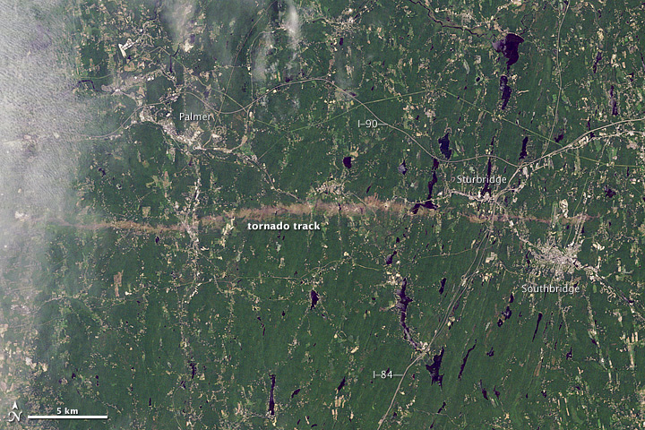
quote:On June 1, 2011, a supercell thunderstorm developed over western Massachusetts. The storm produced an EF3 tornado that cut a 39-mile (63-kilometer) track of destruction across southwest and south-central Massachusetts. Not only did the tornado remain on the ground for many miles, but it also widened to roughly 0.5 miles (0.8 kilometers) in Brimfield State Forest.
The Thematic Mapper on the Landsat 5 satellite captured this natural-color image on June 5, 2011, showing part of the tornado track including damage in Sturbridge. According to The Boston Globe, Massachusetts state police reported a tornado on the ground and cars overturned near Interstate 84 in Sturbridge at 5:22 p.m. on June 1.
When the tornado first touched down in the Munger Hill section of Westfield, Massachusetts, damage was mostly limited to trees, the National Weather Service reported. The tornado quickly intensified, however, as it traveled to West Springfield. The Boston Globe reported two deaths in West Springfield, one in Springfield, and another in Brimfield. The number of people injured was unknown the day after the storm, but 33 people were known to have been injured in Springfield alone.
You better lose yourself in the music
The moment, you own it, you better never let it go
The moment, you own it, you better never let it go

Heftig inderdaad. Zeker een microburst?quote:

Slecht idee inderdaad om uit die auto te komen....quote:
Deze user werd mede mogelijk gemaakt door Yvonne. Bedankt!
Like does the man say 'Is now the time to take of my pants?' ...'Yes.', I said.
Like does the man say 'Is now the time to take of my pants?' ...'Yes.', I said.
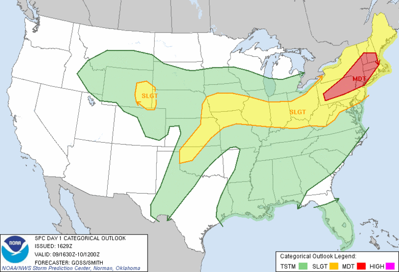
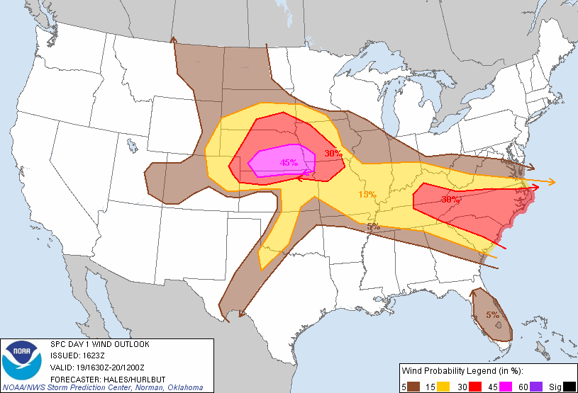
Moderate risk afgegeven voor bijna heel Nebraska. 10% kans op tornado's.
Voor Oklahoma zal vanaf maandag t/m donderdag kans zijn op stormen ( 20/30% )
Voor Oklahoma zal vanaf maandag t/m donderdag kans zijn op stormen ( 20/30% )
Nebraska heeft zowiezo al de noodtoestand afgekondigd vanwege de rivier Missouri
Overstroming Missouri bedreigt kerncentrale
Overstroming Missouri bedreigt kerncentrale
Moderate risk!!!
Kans op tornado's, kans op gevaarlijke wind 120 km/uur of hoger en kans op hagelstenen ter grote van 5 cm of meer.
Tornado
Hagel
Wind
Kans op tornado's, kans op gevaarlijke wind 120 km/uur of hoger en kans op hagelstenen ter grote van 5 cm of meer.
Tornado
Hagel
Wind
Tornadoes Return to the Plains and Midwest
"A swath of widespread wind damage stretching for hundreds of miles is possible."
The stormy weather pattern across the country continues today with severe weather expected from the High Plains into the Ohio Valley.
Similar to what has been going on the last couple of days, thunderstorms will be scattered in nature and, in some cases, organized in large clusters that will travel hundreds of miles.
Ohio Valley
One or more complex of dangerous thunderstorms moving across the Ohio Valley will impact southern Indiana, southern Ohio, Kentucky, Tennessee and western North Carolina as the day progresses.
Torrential downpours and damaging wind gusts will be the most widespread impacts in this zone. The strongest thunderstorms can produce large hail as well.
With daytime heating, additional thunderstorm development will occur outside of organized thunderstorm complexes, which could lead to an isolated tornado threat.
The cities of Cincinnati, Ohio, Paducah, Ky., Nashville, Tenn., and Charlotte, N.C., are at risk.
While lightning and flooding downpours are always a threat, some storms could produce hail and powerful wind gusts capable of knocking down trees and power lines. Should one or more long-lived complexes track through the Ohio Valley, a swath of widespread wind damage stretching for hundreds of miles is possible.
If you choose to go spend some time outdoors today, be sure to seek safe shelter at the first sign of a thunderstorm.
Plains
Another trouble spot for severe weather today and especially tonight will be from the High Plains into the Midwest. This includes the cities of Omaha, Neb., Scottsbluff, Neb., Rapid City, S.D., Minot, N.D., Cheyenne, Wyo., and Pierre, S.D.
Developing low pressure on the eastern side of the Rocky Mountains will tap into some warm, moist air to the south, setting the stage for severe thunderstorm development.
At first, with some daytime heating, thunderstorms will erupt across the High Plains during the afternoon hours. Cities such as Cheyenne, Rapid City, and Minot will need to be on the lookout for rapidly changing conditions during the afternoon and evening.
At first, these storms will be capable of producing hail to the size of baseballs and damaging wind gusts to 65 mph.
The thunderstorms will likely organize into one or more large complexes by the evening and late-night hours, pushing farther east into the Midwest. Nocturnal thunderstorms may affect Lincoln and Omaha along with Bismarck, and perhaps Des Moines after midnight.
Sudden, strong wind gusts above 60 mph in association with heavy rain and pelting hail, known as a downburst, could occur in some of these storms. A brief tornado is also not out of the question, especially during the afternoon and early evening hours.
The weather will have to be watched carefully in Omaha, Neb., where two College World Series games are being played. The weather should be dry for the game at 1 p.m. CDT, but thunderstorms could be bearing down on Omaha by the 6 p.m. CDT game.
Unfortunately, parts of the Midwest will be targeted by strong storms again on Monday as the wet, stormy pattern continues into early next week.
Bron: Accuweather
"A swath of widespread wind damage stretching for hundreds of miles is possible."

The stormy weather pattern across the country continues today with severe weather expected from the High Plains into the Ohio Valley.
Similar to what has been going on the last couple of days, thunderstorms will be scattered in nature and, in some cases, organized in large clusters that will travel hundreds of miles.
Ohio Valley
One or more complex of dangerous thunderstorms moving across the Ohio Valley will impact southern Indiana, southern Ohio, Kentucky, Tennessee and western North Carolina as the day progresses.
Torrential downpours and damaging wind gusts will be the most widespread impacts in this zone. The strongest thunderstorms can produce large hail as well.
With daytime heating, additional thunderstorm development will occur outside of organized thunderstorm complexes, which could lead to an isolated tornado threat.
The cities of Cincinnati, Ohio, Paducah, Ky., Nashville, Tenn., and Charlotte, N.C., are at risk.

While lightning and flooding downpours are always a threat, some storms could produce hail and powerful wind gusts capable of knocking down trees and power lines. Should one or more long-lived complexes track through the Ohio Valley, a swath of widespread wind damage stretching for hundreds of miles is possible.
If you choose to go spend some time outdoors today, be sure to seek safe shelter at the first sign of a thunderstorm.
Plains
Another trouble spot for severe weather today and especially tonight will be from the High Plains into the Midwest. This includes the cities of Omaha, Neb., Scottsbluff, Neb., Rapid City, S.D., Minot, N.D., Cheyenne, Wyo., and Pierre, S.D.
Developing low pressure on the eastern side of the Rocky Mountains will tap into some warm, moist air to the south, setting the stage for severe thunderstorm development.
At first, with some daytime heating, thunderstorms will erupt across the High Plains during the afternoon hours. Cities such as Cheyenne, Rapid City, and Minot will need to be on the lookout for rapidly changing conditions during the afternoon and evening.
At first, these storms will be capable of producing hail to the size of baseballs and damaging wind gusts to 65 mph.
The thunderstorms will likely organize into one or more large complexes by the evening and late-night hours, pushing farther east into the Midwest. Nocturnal thunderstorms may affect Lincoln and Omaha along with Bismarck, and perhaps Des Moines after midnight.
Sudden, strong wind gusts above 60 mph in association with heavy rain and pelting hail, known as a downburst, could occur in some of these storms. A brief tornado is also not out of the question, especially during the afternoon and early evening hours.
The weather will have to be watched carefully in Omaha, Neb., where two College World Series games are being played. The weather should be dry for the game at 1 p.m. CDT, but thunderstorms could be bearing down on Omaha by the 6 p.m. CDT game.
Unfortunately, parts of the Midwest will be targeted by strong storms again on Monday as the wet, stormy pattern continues into early next week.
Bron: Accuweather

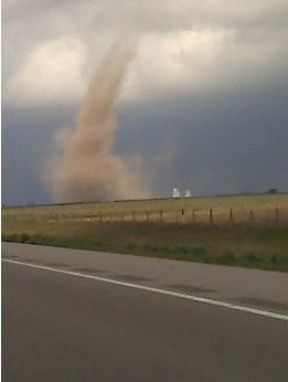
Tornedo on the ground report 9 miles north of Hill City crossing highway 283.
Total of 5 (unconfirmed) reported touch downs in the area
bron: http://www.kwch.com/weather/alwayson/
Total of 5 (unconfirmed) reported touch downs in the area
bron: http://www.kwch.com/weather/alwayson/
You better lose yourself in the music
The moment, you own it, you better never let it go
The moment, you own it, you better never let it go
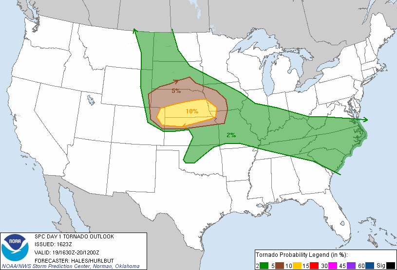
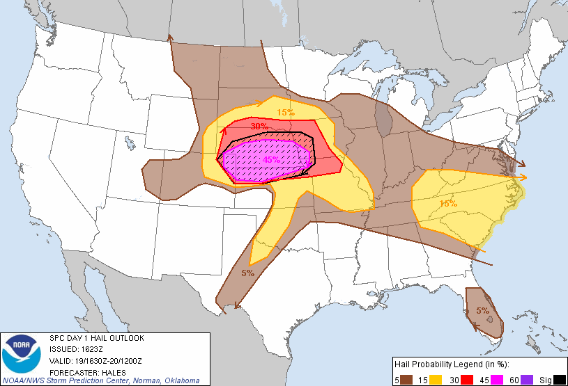
Ohhh dit kan wel eens spektakel worden vannacht. Het moderatie risk gebied is helemaal naar Oklahoma getrokken.
Tipje dus: Als je tornado's wilt zien vannacht, Oklahoma is the place
[ Bericht 22% gewijzigd door Drassss op 21-06-2011 00:51:42 ]
Tipje dus: Als je tornado's wilt zien vannacht, Oklahoma is the place
[ Bericht 22% gewijzigd door Drassss op 21-06-2011 00:51:42 ]
Paar cellen momenteel in Minnesota die er behoorlijk dreigend uitzien. Eén daarvan al een tornado warning.
1 van de streamers: http://content.wdtinc.com(...)0220&C=20211&O=10104
1 van de streamers: http://content.wdtinc.com(...)0220&C=20211&O=10104
Heb je de hail warnings aanstaan onder kopje severe? Er is een gebied met "very large hail possible".quote:Op vrijdag 1 juli 2011 23:46 schreef Drassss het volgende:
Paar cellen momenteel in Minnesota die er behoorlijk dreigend uitzien. Eén daarvan al een tornado warning.
1 van de streamers: http://content.wdtinc.com(...)0220&C=20211&O=10104
be nice or go away