WKN Weer, Klimaat en Natuurrampen
Lees alles over het onstuimige weer op onze planeet, volg orkanen en tornado's, zie hoe vulkanen uitbarsten en hoe Moeder Aarde beeft bij een aardbeving. Alles over de verwoestende kracht van onze planeet en tal van andere natuurverschijnselen.


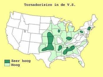
Extreem weer in de V.S.
De Verenigde Staten kennen extreme weersituaties. Tornado's en orkanen eisen elk jaar tientallen levens. Plotseling opkomende onweersbuien zijn vooral in Florida gevaarlijk. In bergachtige gebieden en in woestijnen neemt de grond weinig water op en veranderen beekjes als gevolg van hevige regenval plotseling in kolkende watermassa's.
]
Tornado's
Tornado's ontstaan overal in de Verenigde Staten, maar het merendeel ten oosten van de Rocky Mountains in Texas, Kansas en Oklahoma, ook wel Tornado Alley genoemd. Jaarlijks razen ongeveer 1000 tornado's over de Verenigde Staten.
Er zijn twee tornadoseizoenen. De eerste is in april en mei en het tweede in november. In november beperken de tornado's zich tot Alabama, Mississippi en Louisiana.
Florida is berucht wegens het grote aantal onweersdagen. In Lightning Alley onweert het op meer dan 90 dagen per jaar.
vorige delen
Deel1: Weeralarm VS: Ongewoon zwaar tornadoseizoen
Deel2: Weeralarm V.S. #2 Extreem weer - Tornado touchdown!
Deel3: Weeralarm V.S. #3 Extreem weer - Tornado touchdown
enkele site's voor informatie
http://www.news9.com/
http://www.tornadovideos.net/
http://www.accuweather.com/news.asp
Amerikaanse weerinstituut National Weather Service
Voor orkanen is er: Hurricane Season 2010 - Things are about to change...
Hagelstenen van een onweersbui bij Oklahoma City
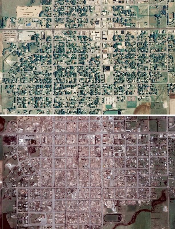
Foto Greensburg voor en na de Tornado Ramp
[ Bericht 7% gewijzigd door #ANONIEM op 15-04-2011 14:32:56 ]

De Verenigde Staten kennen extreme weersituaties. Tornado's en orkanen eisen elk jaar tientallen levens. Plotseling opkomende onweersbuien zijn vooral in Florida gevaarlijk. In bergachtige gebieden en in woestijnen neemt de grond weinig water op en veranderen beekjes als gevolg van hevige regenval plotseling in kolkende watermassa's.
]
 ]
]Tornado's
Tornado's ontstaan overal in de Verenigde Staten, maar het merendeel ten oosten van de Rocky Mountains in Texas, Kansas en Oklahoma, ook wel Tornado Alley genoemd. Jaarlijks razen ongeveer 1000 tornado's over de Verenigde Staten.
Er zijn twee tornadoseizoenen. De eerste is in april en mei en het tweede in november. In november beperken de tornado's zich tot Alabama, Mississippi en Louisiana.
Florida is berucht wegens het grote aantal onweersdagen. In Lightning Alley onweert het op meer dan 90 dagen per jaar.
Nieuwsberichten, foto's, filmpjes over tornado's, onweer, overstromingen etc etc kun je hier in dit topic kwijt.quote:Tornado Parkersburg tweede EF5 van de eeuw
De tornado die zondagmiddag om 18 uur door Parkersburg in de stad Iowa trok is gedefinieerd als een EF-5 tornado. Daarmee is sprake van de tweede EF5-tornado van deze eeuw. De laatste keer dat dit gebeurde was op 4 mei 2007 in Greensburg (Kansas).
De tornado in Parkersburg was de zwaarste tornado voor Iowa sinds 1976. De tornado trok met windsnelheden van 328 kilometer per uur door het dorp en had een breedte van 800 meter. Daarbij vielen volgens de officiële statistiek van de Nationale Weerdienst 6 doden. 50 mensen raakten gewond.
Bron
vorige delen
Deel1: Weeralarm VS: Ongewoon zwaar tornadoseizoen
Deel2: Weeralarm V.S. #2 Extreem weer - Tornado touchdown!
Deel3: Weeralarm V.S. #3 Extreem weer - Tornado touchdown
enkele site's voor informatie
http://www.news9.com/
http://www.tornadovideos.net/
http://www.accuweather.com/news.asp
Amerikaanse weerinstituut National Weather Service
Voor orkanen is er: Hurricane Season 2010 - Things are about to change...
Hagelstenen van een onweersbui bij Oklahoma City
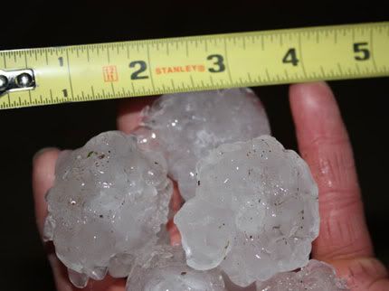
Foto Greensburg voor en na de Tornado Ramp
[ Bericht 7% gewijzigd door #ANONIEM op 15-04-2011 14:32:56 ]

Strong Storm, Tornado Threat Shifts to the Southeast
Following deadly tornadoes and strong thunderstorms across the nation's midsection late Thursday, the threat for powerful storms will shift to the Southeast today.
A line of damaging thunderstorms will plow through the lower Mississippi Valley first today, impacting cities such as Alexandria, La., Vicksburg, Miss., and Jackson, Tenn., this morning.
By this afternoon and evening, more storms are expected to blossom farther east, making for a potentially active severe weather day across the Mississippi Delta region, the Florida Panhandle, much of Alabama and Mississippi and areas north to the Ohio Valley.
The primary threat from most of the storms will be powerful wind gusts, perhaps greater than 70 mph, as well as large hail that could shatter car windshields and damage homes.
The threat for tornadoes is also particularly high today. Whether at work, home or on the road, stay alert for any possible tornado warnings and seek a safe shelter right away if warned.
Safe shelters for those indoors include basements, interior closets and hallways. Mobile homes and vehicles should be abandoned for a secure building right away.
Cities that are under the threat for severe storms today include Evansville, Ind., Louisville and Bowling Green, Ky., Nashville, Tenn., Huntsville, Birmingham and Montgomery, Ala., Jackson, Miss., Baton Rouge and New Orleans, La., and Pensacola, Fla.
Numerous interstates will be impacted, including I-10, I-24, I-40, I-55, I-59, I-65 and I-85.
Given the powerful nature of the parent storm system, the threat for severe thunderstorms and isolated tornadoes will persist well after dark as storms march east into western Florida, Georgia and the southern Appalachians.
Asheville, N.C., Atlanta, Ga., and Tallahassee, Fla., are among the locations that could see a dangerous thunderstorm by nightfall.
On Saturday, severe storms could approach the Atlantic coastline, threatening communities from the Delmarva Peninsula south to the coast of eastern Florida.

Following deadly tornadoes and strong thunderstorms across the nation's midsection late Thursday, the threat for powerful storms will shift to the Southeast today.
A line of damaging thunderstorms will plow through the lower Mississippi Valley first today, impacting cities such as Alexandria, La., Vicksburg, Miss., and Jackson, Tenn., this morning.
By this afternoon and evening, more storms are expected to blossom farther east, making for a potentially active severe weather day across the Mississippi Delta region, the Florida Panhandle, much of Alabama and Mississippi and areas north to the Ohio Valley.
The primary threat from most of the storms will be powerful wind gusts, perhaps greater than 70 mph, as well as large hail that could shatter car windshields and damage homes.
The threat for tornadoes is also particularly high today. Whether at work, home or on the road, stay alert for any possible tornado warnings and seek a safe shelter right away if warned.
Safe shelters for those indoors include basements, interior closets and hallways. Mobile homes and vehicles should be abandoned for a secure building right away.
Cities that are under the threat for severe storms today include Evansville, Ind., Louisville and Bowling Green, Ky., Nashville, Tenn., Huntsville, Birmingham and Montgomery, Ala., Jackson, Miss., Baton Rouge and New Orleans, La., and Pensacola, Fla.

Numerous interstates will be impacted, including I-10, I-24, I-40, I-55, I-59, I-65 and I-85.
Given the powerful nature of the parent storm system, the threat for severe thunderstorms and isolated tornadoes will persist well after dark as storms march east into western Florida, Georgia and the southern Appalachians.
Asheville, N.C., Atlanta, Ga., and Tallahassee, Fla., are among the locations that could see a dangerous thunderstorm by nightfall.
On Saturday, severe storms could approach the Atlantic coastline, threatening communities from the Delmarva Peninsula south to the coast of eastern Florida.
quote:
quote:OKLAHOMA CITY -- Severe storms that extended east of I-35 from Ardmore to Ponca City caused large hail, multiple tornadoes and one fatality Thursday.
One person was killed and four people were critically injured in Tushka in Atoka County. The sheriff reported the school was heavily damaged and part of the roof was blown off at Walmart. Many homes and businesses in the town five miles south of Atoka were damaged when a large tornado moved through the area.
Track storms using News 9's Interactive ESP Radar
Severe Weather
At 4:15 p.m. storm spotters confirmed a very dangerous tornado moving near Shidler, northeast at 30 mph. Shidler is located about 30 miles east of Ponca City.
Another tornado was spotted in southeastern Oklahoma near Davis.
A third tornado was spotted northeast of Stroud at about 4:42 p.m. People in the area said the funnel appeared for only a minute or so, but blew out some windows in the area.
A tornado touched down near Welty at about 6:15 p.m. Welty is 15 miles south of Bristow.
A tornado was reported just north of Madill at 6:10 p.m. overturning three tractor trailers and damaging power lines. The Oklahoma Highway Patrol said it may have hit a trailer park, but no injuries were reported. Marshall County Emergency Management Director Hubert Weaver said three structures had roof damage from the storm that hit east of town near Highway 99.
Storm trackers also spotted a tornado near Milburn at about 7 p.m.
Osage County deputy emergency management director Adrian Horn said a twister touched down near Hominy Thursday, damaging at least one home and a business, and knocking down telephone poles, power lines and trees. There were no reports of injuries.
Horn also said officials were trying to confirm whether a tornado touched down near Burbank.
Pontotoc County Emergency Management reported downed power lines and tree limbs in the Allen and Stonewall areas. Additional damage was reported south of Stonewall toward Fittstown where one trailer had its roof blown off and three homes lost roofs. A tree also fell on a car. Softball size hail was reported west of Hickory.
Because of the severity of the storms, it is important to make sure you and your family have a severe weather plan, and know where you're going to take shelter if necessary.
CNN zou inmiddels negen doden meldenquote:At least seven dead in powerful storms
Atlanta (CNN) -- At least seven people in Oklahoma and Arkansas have died as the result of a powerful line of storms now pushing into the Southeast, authorities said Friday.
The system posed the greatest threat Friday to parts of Alabama and Mississippi, where forecasters warned of possible tornadoes, large hail and damaging winds. Forecasters said severe weather was possible Friday afternoon across northern Mississippi and Alabama and into central Tennessee.
The National Weather Service issued tornado warnings for at least eight counties in Mississipi for Friday morning, indicating tornadoes were occurring or imminent.
"We're in the bull's-eye now," said Gregg Flynn of the Mississippi Emergency Management Agency, who said the front came in earlier than expected. There were no reports of major damage Friday morning.
The storm tore through parts of the Midwest on Thursday, leaving a trail of downed trees and power lines, scattered cars and crushed homes as it moved east. It killed two people in the southeastern Oklahoma city of Tushka, where authorities say a tornado touched down Thursday night. It also left five dead when trees fell on homes in four separate Arkansas incidents, authorities said.
Nearly 36,000 people were without power Friday morning in Arkansas, half of them in Pulaski County, the state Department of Emergency Management reported.
The five deaths reported in Arkansas came from trees falling on homes, agency spokesman Tommy Jackson said.
The victims included a 24-year-old man and an 18-month-old girl who died when a tree fell on their trailer while they were sleeping in Garland County, the sheriff's office there said.
"It was terrifying, seeing that this could happen to anybody," Zach Kelly told CNN affiliate KTHV. "There are so many trees around this neighborhood and it was just a scary thought walking over here that this could happen to any family here, including mine."
In Bald Knob, Arkansas, a 6-year-old boy died when a tree fell on his house, KTHV reported. A man died in Scott, Arkansas when a tree fell into his recreational vehicle, crushing him, according to police. The Arkansas Department of Emergency Management also reported a death from a falling tree in St. Francis County.
In Oklahoma, in addition to the two deaths, the storm caused 15 injuries and extensive property damage in the southeastern town of Tushka, about 125 miles south of Tulsa. The state Department of Emergency Management said a "relatively large" tornado sliced through the area around Tushka.
"There's a tremendous amount of property damage," said Capt. Jeff Sewell with the Oklahoma Highway Patrol. "Cars have been blown together. A lot of electric wires are down all over the place. Several houses were totally destroyed."
In Oklahoma, the weather service received reports from media and trained storm spotters who witnessed the tornado in Tushka. Sewell said the tornado stayed on the ground for seven miles.
The tornado was reported about three miles north of Caney, Oklahoma, near the towns of Tushka and Atoka, said Lamont Bain with the National Weather Service in Norman, Oklahoma.
Damage was also reported in the city of Hominy; in the Allen and Stonewall areas of Pontotoc County; and in the Madill area, the state Department of Emergency Management said.
South of Stonewall, a trailer had its roof blown off and three other homes also lost their roofs, the department said. A tree fell on a car, and softball-sized hail was reported near Hickory.
Severe weather could be in store for much of the Midwest and Southeast this weekend.
Eastern Missouri, central and southern Illinois, southwest Indiana and parts of Kentucky, Tennessee, Georgia and the Florida panhandle could also see severe weather through early Saturday as moist air spreading out from the Gulf collides with a cold front pushing east from the Plains, the weather service said.
The forecast from the National Weather Service says the primary threat outside of Mississippi and Alabama will be damaging thunderstorm winds, but there also will be the possibility of isolated tornadoes.
Zie ook:
Doden door zware stormen in de VS
Doden door zware stormen in de VS
quote:Zeker zeven doden in de VS
Bij zware stormen in de Amerikaanse staten Oklahoma en Arkansas zijn zeker zeven doden gevallen, onder wie twee kinderen. Twee mensen, een man van 24 en een peuter van 18 maanden, werden gedood toen een boom op hun caravan viel.
Een 6-jarige jongen werd ook gedood door een boom die op zijn huis viel. Zijn moeder en haar andere kind kwamen met de schrik vrij.
Een andere man werd in zijn auto gedood, ook door een omvallende boom.
School
In Oklahoma werd door een tornado een school verwoest in het stadje Tushka. Daar vielen ook twee doden.
De zevende dode viel doordat zijn woonwagen door de wind werd opgetild en in een nabijgelegen veld werd neergesmakt.
Na Oklahoma en Arkansas trok de storm verder naar de staten Tennessee, Louisiana en Mississippi.

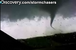
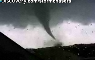
Reed Timmer (tornado chaser) zit in Jackson laat ie weten via zijn site/twitter.
"Red Alert" voor die plaats nu
"Red Alert" voor die plaats nu
http://www.kfor.com/video(...)ather/Stroud-Tornado
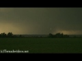
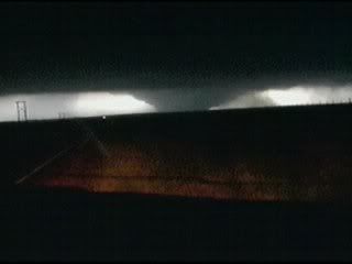
Tornado van gisteren in Noord-oost Oklahoma, Stroud.
Tornado van gisteren in Noord-oost Oklahoma, Stroud.
WTF, heftig! Ik dacht dat het wel mee zou vallen met die lijn.
's Avonds een man, overdags rustig an
http://weather.wdtinc.com(...)0220&C=20211&O=10245
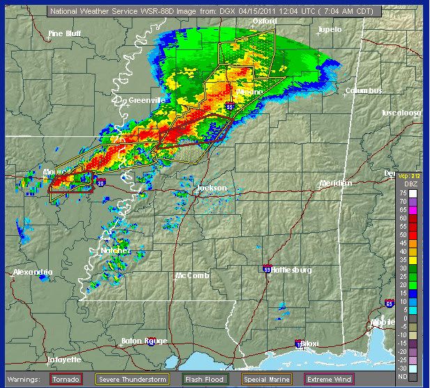
Chaser die oost van een supercell aan het rijden is, die een tornadowarning heeft. Best goed te zien op de radar ( west van Jackson ).
Chaser die oost van een supercell aan het rijden is, die een tornadowarning heeft. Best goed te zien op de radar ( west van Jackson ).
quote:Large tornado reported on ground near Dekalb, Miss. Same cell that produced damage near Jackson, Miss.

Ik zie het, en er waren er al behoorlijk wat geweest. Eng hoor, ik hoop echt dat er geen meer over een dorp/stad heen gaat.quote:Op vrijdag 15 april 2011 21:29 schreef Drassss het volgende:
De één naar de andere cel nu met een haak en dus een tornadowarning...
be nice or go away
Het is nog lang niet voorbij vandaag.. dus ben er maar bang voor.quote:Op vrijdag 15 april 2011 21:31 schreef kahaarin het volgende:
[..]
Ik zie het, en er waren er al behoorlijk wat geweest. Eng hoor, ik hoop echt dat er geen meer over een dorp/stad heen gaat.

Ben ik ook wel, tornadoes zijn verschrikkelijk mooie fenomenen zolang ze in het open veld huishouden.quote:
[..]
Het is nog lang niet voorbij vandaag.. dus ben er maar bang voor.
be nice or go away
Die mensen in die auto op de brug..... Die ontkwamen maar nét!quote:
Deze user werd mede mogelijk gemaakt door Yvonne. Bedankt!
Like does the man say 'Is now the time to take of my pants?' ...'Yes.', I said.
Like does the man say 'Is now the time to take of my pants?' ...'Yes.', I said.
Downtown Tuscaloosa waarschuwing nu
dat is geen fokking kleine stad
Moet er niet aan denken dat die een downtown F-zoveel krijgen
dat is geen fokking kleine stad
Moet er niet aan denken dat die een downtown F-zoveel krijgen


Downtown Tusca wordt gemist gelukkig, maar zuidelijke buitenwijken nietquote:If you live south of I 20-59 near #Tuscaloosa, you are in grave #tornado danger. Get underground if possible, or closet/bathroom. #rtr
quote:Large tornado sighted near McFarland Mall in Tuscaloosa County #alwx
quote:Dodental stijgt naar negen
In de Midwest van de VS hebben tornado's negen mensenlevens geëist en soms zware schade aangericht. Onder de slachtoffers zijn ook drie kinderen, zo is vandaag officieel meegedeeld.
Vooral de staat Arkansas is getroffen. Daar kostte het natuurgeweld afgelopen nacht het leven aan zeven mensen. Dat gebeurde toen ontwortelde bomen op huizen of kampeerwagens vielen. De storm trok ook een spoor van vernieling door Little Rock, de hoofdstad van de staat.
Vandaag zijn ook tornado's gemeld in Mississippi en Alabama. Tientallen huizen en een raffinaderij raakten beschadigd. (afp/adv)
gaat lekker daarquote:At least 3 supercells now taking aim on the Birmingham Metro Area over the next few hours. This is a VERY DANGEROUS situation
Oh shoot, bah bah, Reed Timmer heeft weer eens een voorruit verspeeld, massive hail staat er.quote:
[..]
Downtown Tusca wordt gemist gelukkig, maar zuidelijke buitenwijken niet
[..]
be nice or go away
quote:Developing: ***Significant damage reported in parts of Tuscaloosa County, Alabama from tornado on the ground***
ja zag net ergens ook staan dat ie langs de kant stondquote:
[..]
Oh shoot, bah bah, Reed Timmer heeft weer eens een voorruit verspeeld, massive hail staat er.
Hij is alweer onderweg nu.quote:
[..]
ja zag net ergens ook staan dat ie langs de kant stond
be nice or go away
CARGLASS!quote:
[..]
Hij is alweer onderweg nu.Vast ergens iets geritseld.
Lol, dat geluk heeft hij dan weer idd.quote:
Hmm, ziet er niet goed uit: http://www.accuweather.co(...)ction-spreads-fr.asp Ze verwachten morgen ook nog ongein.
be nice or go away
Tien doden inmiddels:
http://www.skyvalleychron(...)ior-tornadoes-641211
Tornedo Watch alert voor Atlanta, Georgia
http://www.wsbtv.com/weather/27560636/detail.html
En de nacht is daar nog niet voorbij
http://www.skyvalleychron(...)ior-tornadoes-641211
Tornedo Watch alert voor Atlanta, Georgia
http://www.wsbtv.com/weather/27560636/detail.html
En de nacht is daar nog niet voorbij
You better lose yourself in the music
The moment, you own it, you better never let it go
The moment, you own it, you better never let it go
Noodweer eist meer levens in VS
quote:Het dodental als gevolg van het noodweer met tornados, dat sinds donderdag het midden en zuiden van de Verenigde Staten teistert, is zaterdag gestegen tot zeventien. In de nacht van vrijdag op zaterdag kwamen zeven mensen in de staat Alabama om het leven. Dat meldden Amerikaanse media zaterdag.
De meeste slachtoffers werden getroffen door bomen die omwaaiden. In het zuidwesten van Alabama kwamen een moeder en twee kinderen om toen een tornado de stacaravan met gezin en al optilde en bijna 100 meter verder op de grond smeet.
Praat mee over het noodweer in de Verenigde Staten in dit topic. Hier zijn tevens filmpjes en foto's van de tornado's te vinden.
Shiz@autocorrectie"Als er een nieuwsicoon staat, foto-onderschrift, elk woord goed gespeld is en quotes kloppen en er staat 'Ik heb geen het is wanneer blijkt dat gisteren voor de dag dan dat kan ik weet toe maar anders ja veel', mis ik het."
Vandaag weer een High risk voor severe weather.
Over the past few days, a storm system marching across the country has unleashed deadly thunderstorms from the southern Plains into the Southeast. It will be the southern Atlantic Seaboard's turn to face the vicious storms today.
The thunderstorms will roar eastward from the Appalachians toward the coast as the day unfolds. The potential for severe weather will menace a vast part of the Southeast coast, from Washington, D.C., to Savannah, Ga.
The most violent of the storms along this zone will be capable of producing tornadoes. The highest threat for tornadoes will be over eastern North Carolina.
Damaging wind gusts are another threat from today's storms. Gusts past 60 mph at times could damage buildings, topple tractor trailers and down trees and power lines.
The thunderstorms will also unleash torrential downpours, large hail and vivid lightning. An inch or two of rain could pour over some areas in a matter of hours, which could trigger flash flooding problems.
Norfolk, Va., Raleigh, N.C., Charleston, S.C., and Augusta, Ga., are among the cities and towns that lie within the area at risk for these thunderstorms.
By tonight, the storm system's cold front will sweep offshore allowing dry weather to return, except for a few gusty thunderstorms lingering along the immediate coastline during the evening hours.
In the meantime, torrents of rain will pour over the Northeast before slowly tapering off as the storm departs on Sunday.

Ik zie weer genoeg tornado warnings momenteel.. ( high risk gebied ) Wat een ellendig weekend daar qua weer zeg.
13 minuten geleden:
8 minuten geleden:quote:Tornado reported on ground near Elkton, N.C., moving NE; others reportedly headed toward Myrtle Beach, S.C. - Stormchasers
0.01 uurquote:Over 30 tornadoes reported in outbreak called major and extremely dangerous in N.C. - Stormchasers
quote:TWCBreaking
#Tornado sighted 5 miles W of Goldsboro, NC. TAKE COVER IN CITY OF GOLDSBORO NOW! http://wxch.nl/if5uvZ
Shiz@autocorrectie"Als er een nieuwsicoon staat, foto-onderschrift, elk woord goed gespeld is en quotes kloppen en er staat 'Ik heb geen het is wanneer blijkt dat gisteren voor de dag dan dat kan ik weet toe maar anders ja veel', mis ik het."
Noodweer eist meer levens in VS
WASHINGTON - Het dodental als gevolg van het noodweer met tornados, dat sinds donderdag het midden, zuiden en oosten van de Verenigde Staten teistert, is zaterdag gestegen tot 22. Dat meldden Amerikaanse media zaterdag.
De doden vielen in de staten Arkansas (7), Alabama (7), North Carolina (5), Oklahoma (2) en Mississippi (1). Tientallen huizen zijn vernietigd door het natuurgeweld.
De meeste slachtoffers werden getroffen door bomen die omwaaiden. In het zuidwesten van Alabama kwamen een moeder en twee kinderen om toen een tornado de stacaravan met gezin en al optilde en bijna honderd meter verder op de grond smeet.
nu.nl

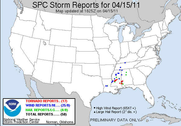
Er zouden 62 tornado's zijn gesignaleerd. Ongetwijfeld zaten er beesten van F3 of F4 tussen.
Never Stop Exploring!
Life begins at the end of your comfort zone!
Follow me on Twitter: https://twitter.com/EdwinKr83 Instagram: https://www.instagram.com/edwinkr83/
Life begins at the end of your comfort zone!
Follow me on Twitter: https://twitter.com/EdwinKr83 Instagram: https://www.instagram.com/edwinkr83/
Komt normaal toch niet voor zo ver naar het Oosten?
Als ik het zo zie, dan ben ik wel blij dat zoiets niet kan gebeuren in Nederland. Of zou zoiets wel mogelijk zijn??
Als ik het zo zie, dan ben ik wel blij dat zoiets niet kan gebeuren in Nederland. Of zou zoiets wel mogelijk zijn??
The line is a dot to you!
WTF! Het is echt enorm losgegaan zeg.. Vreselijk dat er zoveel doden zijn gevallen.
's Avonds een man, overdags rustig an
Een enkele tornado eens in de zoveel jaar komt ook hier voor, maar lang niet zoveel en zo vaak als daar.quote:Op zondag 17 april 2011 11:18 schreef kepler het volgende:
Komt normaal toch niet voor zo ver naar het Oosten?
Als ik het zo zie, dan ben ik wel blij dat zoiets niet kan gebeuren in Nederland. Of zou zoiets wel mogelijk zijn??
Inderdaad apart dat ze zo ver naar het oosten zijn ja, is meestal wat meer naar het midden. Weet iemand of dat vaker voorkomt?
Jawel, maar zo'n groot front is gewoon een samenloop van omstandigheden (wat in Tornado Alley vaker voorkomt). Ik vraag me af of zoiets ook mogelijk is in Nederland/Europa, of moet dat de jetstream heel anders liggen of iets dergelijks?quote:Op zondag 17 april 2011 13:40 schreef nummer_zoveel het volgende:
[..]
Een enkele tornado eens in de zoveel jaar komt ook hier voor, maar lang niet zoveel en zo vaak als daar.
The line is a dot to you!
Een F3 tornado in Chaam en Tricht in 1967:
Het Nederlandse Chaam en ook het Belgische Tricht werden getroffen door een tornado. In Nederland was het de derde tornado van de twintigste eeuw.
De zondag was erg warm. Doordat de warme dag nog vroeg in het seizoen was, was het water van de Atlantische oceaan nog erg koud. In de loop van de dag trok een koudegebied vanuit Ierland via Frankrijk richting Nederland.
Rond 16.30 uur trof een tornado de grond nabij Chaam. De tornado raasde over een lengte van elf kilometer en over een breedte van ongeveer vierhonderd tot zeshonderd meter over het Nederlandse en Belgische grondgebied.
Vervolgens raakte de tornado rond 17.00 uur opnieuw de grond. Ditmaal richtte de tornado verwoestingen aan over een gebied van vijftien kilometer. Honderden huizen en boerderijen werden verwoest. In totaal kwamen 7 mensen om het leven en raakten er 32 gewond.
De kracht van de tornado werd ingeschaald als F3.
Bron
Life is Music
Gelukkig werdt deze (wegtrekkende) roterende zuil geen Tornado...quote:
[..]
Jawel, maar zo'n groot front is gewoon een samenloop van omstandigheden (wat in Tornado Alley vaker voorkomt). Ik vraag me af of zoiets ook mogelijk is in Nederland/Europa, of moet dat de jetstream heel anders liggen of iets dergelijks?
Want dan had ik deze foto('s) niet gemaakt in 2009.


Maar ik kan me nu tenminste voorstellen hoe het is als er een roterende wolk over je heen komt

Foto van de cell over Venlo.

Foto Credit Bram Kuipers, Boekend
[ Bericht 4% gewijzigd door -CRASH- op 17-04-2011 16:39:20 ]
<a href="http://www.vwkweb.nl/" rel="nofollow" target="_blank">[b]Vereniging voor weerkunde en klimatologie[/b]</a>
<a href="http://www.estofex.org/" rel="nofollow" target="_blank">[b]ESTOFEX[/b]</a>
<a href="http://www.estofex.org/" rel="nofollow" target="_blank">[b]ESTOFEX[/b]</a>
Ik weet dat er tornado's voorkomen in Nederland/Europa, maar echt uitbraken met tientallen tornado's? Volgens mij heb je daar dus omstandigheden voor nodig die je alleen tegenkomt in de US?quote:
Een F3 tornado in Chaam en Tricht in 1967:
Het Nederlandse Chaam en ook het Belgische Tricht werden getroffen door een tornado. In Nederland was het de derde tornado van de twintigste eeuw.
De zondag was erg warm. Doordat de warme dag nog vroeg in het seizoen was, was het water van de Atlantische oceaan nog erg koud. In de loop van de dag trok een koudegebied vanuit Ierland via Frankrijk richting Nederland.
Rond 16.30 uur trof een tornado de grond nabij Chaam. De tornado raasde over een lengte van elf kilometer en over een breedte van ongeveer vierhonderd tot zeshonderd meter over het Nederlandse en Belgische grondgebied.
Vervolgens raakte de tornado rond 17.00 uur opnieuw de grond. Ditmaal richtte de tornado verwoestingen aan over een gebied van vijftien kilometer. Honderden huizen en boerderijen werden verwoest. In totaal kwamen 7 mensen om het leven en raakten er 32 gewond.
De kracht van de tornado werd ingeschaald als F3.
Bron
The line is a dot to you!
Grootschalige uitbraken zoals daar in de USA komen hier volgens mij niet echt voor (of zijn heel zeldzaam). Losse exemplaren komen wel regelmatig voor.quote:
[..]
Ik weet dat er tornado's voorkomen in Nederland/Europa, maar echt uitbraken met tientallen tornado's? Volgens mij heb je daar dus omstandigheden voor nodig die je alleen tegenkomt in de US?
Forza Scuderia Ferrari
Subaru Power!
Subaru Power!
Volgens mij is dat hier niet mogelijk in die vormen zoals dat daar gebeurt. Dat komt volgens mij voornamelijk doordat we hier geen extreem vochtige en warme lucht hebben die tegen heel koude kan opbotsen zoals dat daar het geval is van zuid naar het koudere canadese gebergte.
Ik heb wel zin in het buien seizoen in Nederland dit weer is mooi, fijn en leuk maar aan de andere kant ook wel saai.
Ik heb wel zin in het buien seizoen in Nederland
Never Stop Exploring!
Life begins at the end of your comfort zone!
Follow me on Twitter: https://twitter.com/EdwinKr83 Instagram: https://www.instagram.com/edwinkr83/
Life begins at the end of your comfort zone!
Follow me on Twitter: https://twitter.com/EdwinKr83 Instagram: https://www.instagram.com/edwinkr83/
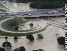
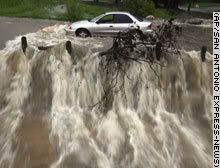
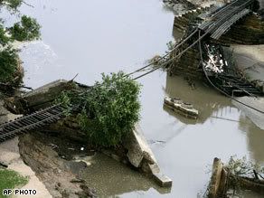
quote:Virginia declares state of emergency after tornadoes kill at least 5
Saturday's tornadoes and flash flooding have killed at least 5 people in Virginia.
Crews are continuing to assess damage from the storms across the state.
In the wake of the severe weather, Governor Bob McDonnell has declared a state of emergency.
“Our thoughts and prayers are with those impacted by the storms and flooding in the Commonwealth. I have declared a state of emergency to direct all possible resources towards responding to this event," says McDonnell.
Virginia Department of Emergency Management spokesman Bob Spieldenner says three- people died in Gloucester County alone, where a tornado cut through 12 miles of land.
The National Weather Service adds that at least one tornado touched down Saturday in Dinwiddie County.
Meanwhile, flash flooding killed a young child and another person in Waynesboro and prompted other water rescues.
We will have more on Saturday's tornadoes coming up Sunday night on News 7 at 6 and 11, and check back here for more updates.
Tornado's in Nederland en BelgiëIn Nederland en België komen ook af en toe tornado's voor, maar vaak zijn het zwakke tornado's, die meestal windhozen genoemd worden. Een enkele keer bereikt ook in Nederland of België een windhoos de kracht van een sterke (Amerikaanse) tornado, zoals op:
10 augustus 1925 in Borculo, zie: stormramp van 1925.
1 juni 1927 bij Neede (F4).[1]
23 augustus 1950 op de Veluwe. Deze tornado had een spoor van 46 kilometer lengte en veroorzaakte vooral schade aan de plaatselijke bossen. Er vielen geen slachtoffers.[2]
27 maart 1966 in Winterswijk, het Winterswijkse Feestgebouw aan de Haitsma Mulierweg werd verwoest. Ook in de omgeving van het Feestgebouw richtte de windhoos veel schade aan. Aan de Wilhelminastraat, de Groenloseweg en Morgenzonweg waaiden daken geheel of gedeeltelijk weg, zoals het dak van de kantine van voetbalvereniging WVC.[bron?]
25 juni 1967 in Oostmalle, Chaam en Tricht (F3).[1]
6 oktober 1981 - Op deze dag vonden 18 mensen de dood, toen een vliegtuig op weg van Rotterdam Airport naar Hamburg in de buurt van Moerdijk in een tornado vloog (vliegtuigongeval Moerdijk). Alle 17 inzittenden en een persoon op de grond kwamen om het leven.
Een historische tornado waarvan de sporen tot op de dag van vandaag zichtbaar zijn is de tornado die tijdens de zomerstorm van 1 augustus 1674 de Dom van Utrecht trof. Het middenschip van de kerk stortte in en sindsdien staat de Domtoren los van de kerk. De brokstukken bleven nog lang liggen, maar na opruiming hiervan is ter plaatse het Domplein aangelegd.
Never Stop Exploring!
Life begins at the end of your comfort zone!
Follow me on Twitter: https://twitter.com/EdwinKr83 Instagram: https://www.instagram.com/edwinkr83/
Life begins at the end of your comfort zone!
Follow me on Twitter: https://twitter.com/EdwinKr83 Instagram: https://www.instagram.com/edwinkr83/


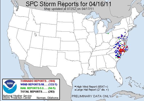
Historic Tornado Outbreak: 3 Days, 241 Tornadoes, 14 States
From Thursday, April 14, 2011 to Saturday, April, 16, 2011, devastating tornadoes rampaged across communities of the southern United States. Cities and towns from Oklahoma to North Carolina were assaulted by the deadly twisters.
The tornado outbreak led to a total of 241 tornado reports in 14 states over the three-day period. This will likely rank this tornado outbreak among the largest in history.
Tragically, the death toll has risen to 39 people so far with dozens of others injured. The number of fatalities could rise as investigations continue. This tornado outbreak already ranks as the most deadly outbreak since the 2008 Super Tuesday tornado outbreak.
In North Carolina alone, close to two dozen people were killed on Saturday, while seven people were killed in Alabama on Friday.
One of the reasons for the deadly outcome of this tornado outbreak is likely due to the highly populated areas of the nation that were hit. The weather pattern can explain why these highly populates areas were struck.
Jackson, Miss., and Raleigh, N.C., are among the large cities that were struck by large, devastating twisters.
Numerous homes, businesses, churches and even schools have been severely damaged or destroyed in the path of the tornadoes.
Setup for Deadly Tornado Outbreak
Three ingredients were in place to allow this violent tornado outbreak to occur from the southern Plains to the Southeast: a powerful jet stream, abundant moisture and a strong cold front.
A powerful jet stream helped to enhance the thunderstorm growth, while moisture surging in from the Gulf of Mexico acted as fuel for the thunderstorms.
A strong cold front plowing across the South was the trigger that initiated the thunderstorm development.
The difference in the direction of wind in the upper atmosphere, southwesterly, and the lower atmosphere, southerly to southeasterly, added a twisting motion that helped the severe thunderstorms to develop a rotation. Thus, the wind difference with height, referred to as wind shear by meteorologists, made the severe thunderstorms more likely to produce tornadoes.
There are a couple of factors that are making this year a more active severe weather year compared to normal and compared to last year.
The first factor is that the water in Gulf of Mexico is warmer than last year. This means that there is very warm, moist air in supply for storm systems to tap into and provide fuel for severe weather.
The second is that we are in one of the strongest La Nina patterns in recorded history.
"The strong La Nina pattern means that tremendous contrasts in air masses, with cool and dry air to the north and warm and steamy air to the south, are occurring over the Mississippi Valley. This puts many highly populated areas in the path of dangerous severe weather," said AccuWeather.com Expert Senior Meteorologist Henry Margusity.
Ranking of Tornado Outbreak Compared to Historic Outbreaks
This mid-April 2011 tornado outbreak is likely to rank among the largest tornado outbreaks in history with 241 tornado reports.
"There has not been a tornado outbreak in history over three days with this many tornadoes spawned by a single storm system," according to Margusity.
The notorious 1974 tornado outbreak, which occurred on April 3-4, 1974, produced 148 tornadoes over the course of two days and is thought of as one of the largest and deadliest tornado outbreak in history from one storm system.
In the infamous May 2003 tornado outbreak sequence (May 4-10), 401 tornadoes occurred. However, multiple storm systems moving from the Southwest into the Plains triggered these tornadoes.
"In 2004, there was a two-day tornado outbreak which produced 170 twisters. In the 2008 Super Tuesday tornado outbreak, there was 131 reported tornadoes in one day," added Margusity.
At this stage, an exact comparison to historic outbreaks in terms of the strength and number of tornadoes cannot be made. It will take weeks for the tornado surveys, which determine the strength and exact number of tornadoes, to be conducted.
From Thursday, April 14, 2011 to Saturday, April, 16, 2011, devastating tornadoes rampaged across communities of the southern United States. Cities and towns from Oklahoma to North Carolina were assaulted by the deadly twisters.
The tornado outbreak led to a total of 241 tornado reports in 14 states over the three-day period. This will likely rank this tornado outbreak among the largest in history.
Tragically, the death toll has risen to 39 people so far with dozens of others injured. The number of fatalities could rise as investigations continue. This tornado outbreak already ranks as the most deadly outbreak since the 2008 Super Tuesday tornado outbreak.
In North Carolina alone, close to two dozen people were killed on Saturday, while seven people were killed in Alabama on Friday.
One of the reasons for the deadly outcome of this tornado outbreak is likely due to the highly populated areas of the nation that were hit. The weather pattern can explain why these highly populates areas were struck.

Jackson, Miss., and Raleigh, N.C., are among the large cities that were struck by large, devastating twisters.
Numerous homes, businesses, churches and even schools have been severely damaged or destroyed in the path of the tornadoes.
Setup for Deadly Tornado Outbreak
Three ingredients were in place to allow this violent tornado outbreak to occur from the southern Plains to the Southeast: a powerful jet stream, abundant moisture and a strong cold front.
A powerful jet stream helped to enhance the thunderstorm growth, while moisture surging in from the Gulf of Mexico acted as fuel for the thunderstorms.

A strong cold front plowing across the South was the trigger that initiated the thunderstorm development.
The difference in the direction of wind in the upper atmosphere, southwesterly, and the lower atmosphere, southerly to southeasterly, added a twisting motion that helped the severe thunderstorms to develop a rotation. Thus, the wind difference with height, referred to as wind shear by meteorologists, made the severe thunderstorms more likely to produce tornadoes.
There are a couple of factors that are making this year a more active severe weather year compared to normal and compared to last year.
The first factor is that the water in Gulf of Mexico is warmer than last year. This means that there is very warm, moist air in supply for storm systems to tap into and provide fuel for severe weather.
The second is that we are in one of the strongest La Nina patterns in recorded history.
"The strong La Nina pattern means that tremendous contrasts in air masses, with cool and dry air to the north and warm and steamy air to the south, are occurring over the Mississippi Valley. This puts many highly populated areas in the path of dangerous severe weather," said AccuWeather.com Expert Senior Meteorologist Henry Margusity.

Ranking of Tornado Outbreak Compared to Historic Outbreaks
This mid-April 2011 tornado outbreak is likely to rank among the largest tornado outbreaks in history with 241 tornado reports.
"There has not been a tornado outbreak in history over three days with this many tornadoes spawned by a single storm system," according to Margusity.
The notorious 1974 tornado outbreak, which occurred on April 3-4, 1974, produced 148 tornadoes over the course of two days and is thought of as one of the largest and deadliest tornado outbreak in history from one storm system.
In the infamous May 2003 tornado outbreak sequence (May 4-10), 401 tornadoes occurred. However, multiple storm systems moving from the Southwest into the Plains triggered these tornadoes.
"In 2004, there was a two-day tornado outbreak which produced 170 twisters. In the 2008 Super Tuesday tornado outbreak, there was 131 reported tornadoes in one day," added Margusity.
At this stage, an exact comparison to historic outbreaks in terms of the strength and number of tornadoes cannot be made. It will take weeks for the tornado surveys, which determine the strength and exact number of tornadoes, to be conducted.
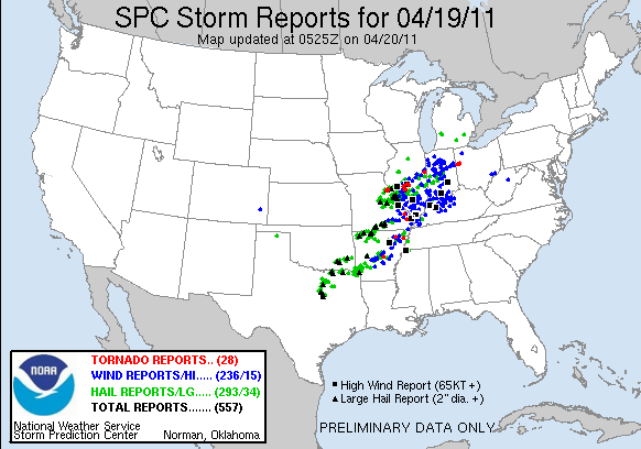
Morgen opnieuw moderate risk.. April wordt op zo'n manier wel een historische maand. Momenteel zijn ze aan het kijken of de outbreak van dit weekend behoort tot het illustere rijtje outbreaks uit het verleden.
's Avonds een man, overdags rustig an
Morgen inderdaad weer extreem weer.
Severe Thunderstorm, Tornado Threat Returns Tuesday
A significant outbreak of severe storms, including destructive tornadoes, is expected again this week, beginning across parts of the central Plains and Mississippi valley on Tuesday.
This new threat comes just days after deadly tornadoes devastated communities in the central Plains and Southeast. Unfortunately, some of those towns could again be struck by strong storms this week.
Beginning late today and tonight, a small area from eastern Kansas to western Kentucky could see a few localized gusty storms before a more widespread threat unfolds.
More thunderstorms are expected to erupt ahead of a strong cold front from the central Plains through the mid-Mississippi valley and into the Ohio valley Tuesday and Tuesday night.
All of the thunderstorms will produce driving downpours and frequent, deadly lightning, while several will also be capable of generating powerful wind gusts and destructive hail.
Unfortunately, conditions will also be ripe for a few tornadoes. While the threat exists for multiple twisters, just one tornado passing through a populated area can cause severe destruction.
Cities at especially high risk for severe storms Tuesday and Tuesday night include Little Rock, Ark., Springfield and St. Louis, Mo., Indianapolis, Ind., and Cincinnati, Ohio.
Powerful storms could also reach as far north as the I-80 corridor, including Chicago, Ill., South Bend, Ind., and Toledo, Ohio.
The threat for severe weather won't end there. By Wednesday, parts of the Tennessee valley, mid-Atlantic and central Appalachians will be at risk for powerful thunderstorms.
Stay with AccuWeather.com early this week for more on this potential severe weather outbreak.
Bron:Accuweather
Severe Thunderstorm, Tornado Threat Returns Tuesday

A significant outbreak of severe storms, including destructive tornadoes, is expected again this week, beginning across parts of the central Plains and Mississippi valley on Tuesday.
This new threat comes just days after deadly tornadoes devastated communities in the central Plains and Southeast. Unfortunately, some of those towns could again be struck by strong storms this week.
Beginning late today and tonight, a small area from eastern Kansas to western Kentucky could see a few localized gusty storms before a more widespread threat unfolds.
More thunderstorms are expected to erupt ahead of a strong cold front from the central Plains through the mid-Mississippi valley and into the Ohio valley Tuesday and Tuesday night.
All of the thunderstorms will produce driving downpours and frequent, deadly lightning, while several will also be capable of generating powerful wind gusts and destructive hail.
Unfortunately, conditions will also be ripe for a few tornadoes. While the threat exists for multiple twisters, just one tornado passing through a populated area can cause severe destruction.
Cities at especially high risk for severe storms Tuesday and Tuesday night include Little Rock, Ark., Springfield and St. Louis, Mo., Indianapolis, Ind., and Cincinnati, Ohio.
Powerful storms could also reach as far north as the I-80 corridor, including Chicago, Ill., South Bend, Ind., and Toledo, Ohio.
The threat for severe weather won't end there. By Wednesday, parts of the Tennessee valley, mid-Atlantic and central Appalachians will be at risk for powerful thunderstorms.
Stay with AccuWeather.com early this week for more on this potential severe weather outbreak.
Bron:Accuweather


Ik ben benieuwd wat er vandaag gaat gebeuren. 10% kans op tornado's.
's Avonds een man, overdags rustig an
Toch schijnen er weer van die zogenaamde weerdudes het beter te weten en zeggen dat de tornado's onverwachts kwamen terwijl het 2 dagen op SPC stond, beetje vaag allemaal en triest dat de media niet even de juiste forums gaat napluizen voor betere berichtgeving!
http://vtm.be/nieuws/buitenland/63550-tornados-kwamen-onverwacht
http://vtm.be/nieuws/buitenland/63550-tornados-kwamen-onverwacht
Weer of geen weer, altijd actueel www.onweer-online.nl
Zucht wat een broekie..Als er iets veel aandacht krijgt is het weer wel...
Je moet echt in een grot gaan wonen wil je niet merken dat er iets staat te gebeuren in je omgeving...
Je moet echt in een grot gaan wonen wil je niet merken dat er iets staat te gebeuren in je omgeving...
Haha, zie die kneus dan ook storm chasen met zijn vrienden in tornado alley België 
's Avonds een man, overdags rustig an
Waar zijn er een beetje goede radarbeelden?
Never Stop Exploring!
Life begins at the end of your comfort zone!
Follow me on Twitter: https://twitter.com/EdwinKr83 Instagram: https://www.instagram.com/edwinkr83/
Life begins at the end of your comfort zone!
Follow me on Twitter: https://twitter.com/EdwinKr83 Instagram: https://www.instagram.com/edwinkr83/
Tja wat is goed. Ik volg het hier meestal.quote:
Waar zijn er een beetje goede radarbeelden?
http://www.news9.com/category/167025/weather-storm-tracker

[ Bericht 34% gewijzigd door Vultarian op 19-04-2011 23:21:48 ]
intelligence has its limits, but stupidity knows no bounds.

Ik zit in de omgeving van Lexington, KY en het gaat hier momenteel aardig los. De storm is nog niet binnen, maar het de windstoten zijn er al wel. Twee counties verderop is er een tornado warning en het zou mij niets verbazen als die er hier ook komt.
Jammer dat ik morgenochtend er vroeg uit moet, maar anders had ik nog even opgebleven om te kijken. Alhoewel ik waarschijnlijk toch wel wakker wordt door de onweer.
Jammer dat ik morgenochtend er vroeg uit moet, maar anders had ik nog even opgebleven om te kijken. Alhoewel ik waarschijnlijk toch wel wakker wordt door de onweer.
Wild April Weather to be Followed by Wicked May
This map looks a lot like what has been going on during much of April. As a result, May will likely bring more of the same, but also more severe weather farther to the north.
Severe weather experts at AccuWeather.com are forecasting the intense weather outbreaks in the U.S. to continue beyond April into much of May.
According to Severe Weather Expert Meteorologist Henry Margusity, "We see no let-up in the weather pattern that has led to the outbreaks this month."
A pronounced temperature contrast often produces strong storm systems.
May is notorious for severe weather and tornadoes in its own right as warmth builds from the strengthening sun, while the upper atmosphere and the low-level air over the northern latitudes remain chilly.
The jet stream tends to hover close to the temperature contrast.
We cannot say that there is a direct correlation between La Nina and a particular outbreak. However, the ocean water temperature anomaly in the Pacific tends to lead to a strong polar jet stream.
While a strong jet stream is a common occurrence in the spring, the presence of a strong, ongoing La Nina has that strong jet stream on steroids.
A strong jet stream is a key contributor to severe weather and tornado outbreaks.
While the ongoing La Nina may weaken slightly in the coming months, it is still rather strong at present. It could continue to fuel, in an indirect way, frequent strong storm systems and the severe thunderstorms they often breed.
As the chilly air around the Great Lakes, Northeast U.S. and neighboring Canada retreats northward, the risk of severe weather will increase in these areas.
While this too is part of the normal northward progression of severe weather in the spring, the strong La Nina driving the strong jet stream may continue to make severe weather matters much worse than normal.
Two other factors, such as warm, moist air from the Gulf of Mexico and intrusions of dry air from the West, are always players in severe thunderstorms.
The Gulf of Mexico is much warmer than average this spring. The extra warmth translates to higher moisture levels (higher dew points) over downwind areas of the land.
In contrast, the air is extremely dry (low dew points) over southern High Plains as evidenced by the drought and wildfires in the region.
Both of these secondary factors, combined with the strong jet stream may be cranking up the potential energy to be released in the form of violent storms.
It is possible that smoke from the wildfires may be limiting severe weather incidents (and tornadoes) over the favored area of southern High Plains.
However, it may be that the air is just too dry and too extensive in that area, pushing the boundary of the dry and moist air (dry line) farther east, closer to the middle and lower Mississippi Valley.
This boundary is often the fuse for severe thunderstorms and tornadoes.
Throw in the strengthening sun and building warmth to the mix during May and we could really have some ferocious storms on our hands.
Bron: Accuweather
Heeft hem al bijna eens zijn oog gekost...quote:
be nice or go away

en toch iedere keer weer bij hem in die auto stappen hèquote:
Heeft hem al bijna eens zijn oog gekost...Je hebt wel gelijk, hij neemt ongelofelijk veel risico.
You better lose yourself in the music
The moment, you own it, you better never let it go
The moment, you own it, you better never let it go
Ja, hehe, dat is de kans op mooie beelden.quote:Op woensdag 20 april 2011 12:05 schreef MaryMouse het volgende:
[..]
en toch iedere keer weer bij hem in die auto stappen hè
Deze staten hebben vandaag tornado watch:
http://www.srh.noaa.gov/mrx/
http://www.erh.noaa.gov/er/rlx/
http://www.erh.noaa.gov/er/rnk/
Lijkt er op dat we vanavond weer mee kunnen kijken.
be nice or go away

quote:Disasterarea North Carolina
President Barack Obama is declaring a major disaster for parts of North Carolina after last weekend's tornadoes.
The announcement Tuesday clears the way for residents to receive federal assistance.
Dozens of tornadoes in central and eastern North Carolina killed at least 23 people and damaged or destroyed more than 800 homes. The declaration affects 18 eastern and central counties. ( The Aftermath of 240 Tornadoes)
Gov. Beverly Perdue asked the president and to U.S. Agriculture Secretary Tom Vilsack for help, seeking low-interest loans for farmers and loans and grants to help others repair their homes and businesses.