WKN Weer, Klimaat en Natuurrampen
Lees alles over het onstuimige weer op onze planeet, volg orkanen en tornado's, zie hoe vulkanen uitbarsten en hoe Moeder Aarde beeft bij een aardbeving. Alles over de verwoestende kracht van onze planeet en tal van andere natuurverschijnselen.


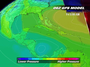
Op de site van JTWC (Joint Typhoon Warning Center) is de kans van dit syteem teruggebracht naar low. Ik denk dat morgen de schaal weer opgehoogd gaat worden naar medium of high risk. (als de GFS kaarten het juist hebben).
Volgens de laatste run (12Z) zal Pakistan een voltreffer krijgen. Vorig jaar vielen hier nog zo'n 2000 doden door overstromingen en raakten miljoenen mensen dakloos.
Overstromingen Pakistan: 1750 doden - Grootste ramp ooit
Volgens de laatste run (12Z) zal Pakistan een voltreffer krijgen. Vorig jaar vielen hier nog zo'n 2000 doden door overstromingen en raakten miljoenen mensen dakloos.
Overstromingen Pakistan: 1750 doden - Grootste ramp ooit
In de Arabische zee is het gebied weer opgehoogd naar medium.
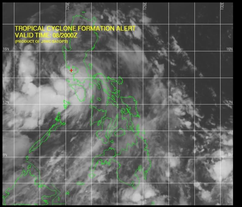
Ook in de West Pacific is een gebied wat opgehoogd is naar medium. (bij de Filipijnen).
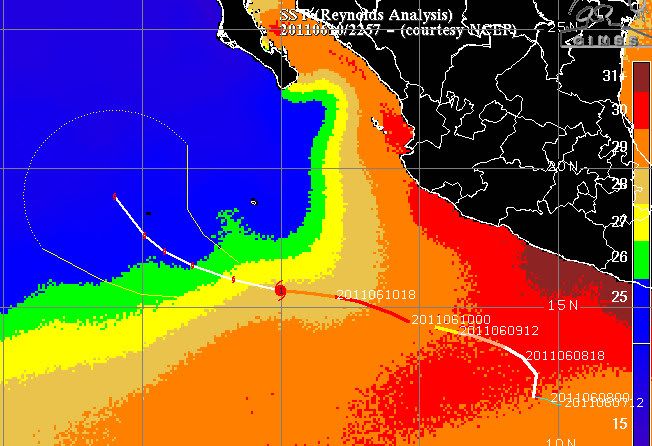
In de Oost Pacific is de tropische depressie veranderd in Tropical storm Adrian. Deze storm zal zich verder ontwikkelen tot orkaan. Waarschijnlijk een cat 2.
Ook in de West Pacific is een gebied wat opgehoogd is naar medium. (bij de Filipijnen).
In de Oost Pacific is de tropische depressie veranderd in Tropical storm Adrian. Deze storm zal zich verder ontwikkelen tot orkaan. Waarschijnlijk een cat 2.

quote:23 doden in Haiti
Zware regenval in Haïti heeft gisteren geleid tot overstromingen en aardverschuivingen. Daardoor zijn zeker 23 mensen om het leven gekomen. Dat hebben de autoriteiten in het Caraïbische land laten weten.
De doden vielen onder meer in het tentenkamp bij het ingestorte presidentiële paleis in de hoofdstad Port-au-Prince. Daar wonen nog altijd veel mensen die bij de zware aardbeving van januari vorig jaar dakloos zijn geraakt. Ook in de luxewijk Petionville zijn veel mensen omgekomen.
Het noodweer wordt veroorzaakt door een lagedrukgebied boven de Caraïbische Zee. Dat kan ook overstromingen en aardverschuivingen veroorzaken in de Dominicaanse Republiek, Jamaica en Cuba, aldus het Amerikaanse orkaancentrum NHC. (anp/adv)
08/06/11 07u27
Tropical Cyclone Possibility on the Arabian Sea
"...at least some of our tools suggest that it could consolidate into a significant tropical low."
A broad area of disturbed weather over the Arabian Sea could give rise to a tropical cyclone by the end of the week.
On Wednesday, satellite pictures of the Arabian Sea showed a large swath of clouds, some having strong thunderstorms, over the open Arabian Sea between western India and Oman, in eastern Arabia.
Satellite image of Arabian Sea shows disturbed weather as of 1300 UTC Wednesday, June 8 (credit: India Meteorology Department).
This tropical weather system has remained loosely organized since late last week, even though at least some of our tools suggest that it could consolidate into a significant tropical low.
An area to watch is a few hundred miles west of Mumbai, India, within 36 to 48 hours.
If a cyclone fails to form, instead, typically unsettled weather that often marks the onset of the rainy South West Monsoon on the Indian Subcontinent is likely.
This would imply continued northward spread of showers and thunderstorms, some with torrential bursts of rain, across much of central and northeastern India during the next several days.
Strong tropical cyclones have sometimes arisen over the Arabian Sea during early June, Super Cyclonic Storm Gonu of 2007 being the ultimate example.
Signs as of Wednesday were still unclear as to whether the present disturbed area will grow into a potentially destructive storm.
Accuweather
"...at least some of our tools suggest that it could consolidate into a significant tropical low."
A broad area of disturbed weather over the Arabian Sea could give rise to a tropical cyclone by the end of the week.
On Wednesday, satellite pictures of the Arabian Sea showed a large swath of clouds, some having strong thunderstorms, over the open Arabian Sea between western India and Oman, in eastern Arabia.

Satellite image of Arabian Sea shows disturbed weather as of 1300 UTC Wednesday, June 8 (credit: India Meteorology Department).
This tropical weather system has remained loosely organized since late last week, even though at least some of our tools suggest that it could consolidate into a significant tropical low.
An area to watch is a few hundred miles west of Mumbai, India, within 36 to 48 hours.
If a cyclone fails to form, instead, typically unsettled weather that often marks the onset of the rainy South West Monsoon on the Indian Subcontinent is likely.
This would imply continued northward spread of showers and thunderstorms, some with torrential bursts of rain, across much of central and northeastern India during the next several days.
Strong tropical cyclones have sometimes arisen over the Arabian Sea during early June, Super Cyclonic Storm Gonu of 2007 being the ultimate example.
Signs as of Wednesday were still unclear as to whether the present disturbed area will grow into a potentially destructive storm.
Accuweather
Adrian is hard op weg om de orkaan status te halen. Het is nu nog een tropische storm met een windveld van 112 km/uur en windstoten tot 136 km/uur. De bijna orkaan verplaatst zich noord/noord west met een snelheid van 7.5 km/uur. De verwachting is dat de windsnelheid gaat oplopen tot zo'n 175 km/uur. (windstoten tot 212 km/uur). Daarmee gaat het een cat 2 worden.
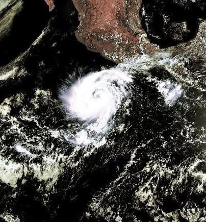


De storm in de Arabische zee is opgehoogd naar een high risk. Langzaam neemt deze in kracht toe en lijkt de meeste overlast te gaan veroorzaken voor Pakistan.
quote:Adrian Becomes Category 3 Hurricane
Satellite image of Hurricane Adrian taken early this morning shows signs of further strengthening.
Tropical Storm Adrian, the first hurricane of 2011, is now a Category 3 storm in the eastern Pacific.
Adrian was upgraded to a hurricane Wednesday evening and was upgraded to Category 3 status at 8 a.m. PDT.
After organizing into the first tropical depression of the 2011 Eastern Pacific Hurricane Season on Tuesday morning, rapid strengthening continued throughout the day. The depression was named
The AccuWeather.com Hurricane Center has the latest stats on Hurricane Adrian, which is sitting southwest of Acapulco, Mexico.
Satellite images continue to show further strengthening and organization.
"The rapid strengthening occurred due to very little wind shear in the area. This is allowed showers and thunderstorms to blow up and wrap around the tropical storm's center," said AccuWeather.com Expert Senior Meteorologist Bob Smerbeck.
According to AccuWeather.com Hurricane Expert Dan Kottlowski, "The hurricane is expected to continue on a northwest track through the eastern Pacific over the next few days, keeping the system away from Mexico."
"s Adrian continues on this course, it will eventual wander over much cooler waters, which will cause the storm to weaken," Kottlowski added.
Battering surf will affect the coastline. There could be some beach erosion and minor coastal flooding with the storm passing a couple hundred miles away from the coast.
Depending on how closely Adrian hugs the Mexico Coast as it shifts northwest, some outer bands of rain and thunderstorms as well as gusty winds could also lash westernmost Mexico in the coming days.
There are a couple of computer models that are still indicating a track farther to the north, which would take the system toward Mexico. These models are showing the storm approaching Mexico somewhere between Jalisco and Michoacan or northern Guerro.
The northern track would mean more impact as far as heavy rain, damaging winds, rough surf and storm surge goes. There would even be the threat of violent thunderstorms and tornadoes to the north and east of the storm's center at landfall if this scenario were to play out.
People who live along the west coast of Mexico should continue to monitor the progress of the storm. Keep checking back for the latest updates on AccuWeather.com.

quote:Tropical Depression Douses Philippines
Torrential rain triggered flooding in parts of the Philippines as a tropical depression spun up nearby.
According to the Straits Times of Singapore, at least three people have been killed by floods following days of heavy rain as of Thursday. Nearly 200,000 people have been adversely affected, as schools have shut and traffic was disrupted.
Two teenagers died in North Cotabato province, the Times said. North Cotabato is on the southern island of Mindanao.
In Manila, there were school closings and flight cancelations Thursday.
Weather data accessed by AccuWeather.com show that rainfall in and about Manila was 4 to at least 8 inches within 24 to 36 hours as of Thursday. June, which marks the start of the rainy season in Manila, has about 10 inches of rain through the month, on average, in the Philippine capital city.
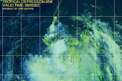
Meanwhile, the tropical depression, designated TD 05W (Five) by the Joint Typhoon Warning Center, was drifting northwestward off western Luzon Island Thursday. TD Five could become a tropical storm prior to making landfall in southeastern China before the end of the week.
Joint Typhoon Warning Center Image shows TD Five near Luzon Island, Philippines, June 9, 2011.
quote:
Ik heb de inhoud van de post naar Weeralarm V.S. # 9 Extreem weer - 3e nacht tornado's? gekopieerdquote:
You better lose yourself in the music
The moment, you own it, you better never let it go
The moment, you own it, you better never let it go

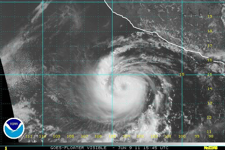
bron: http://www.nnvl.noaa.gov/(...)ID=754&MediaTypeID=1quote:Hurricane Adrian is a Category 3 hurricane with sustained winds of 115 knots off the west coast of Mexico. Conditions are favorable for further strengthening in the next 24 hours before the storm begins to be affected by stable air and cooler waters. Adrian is moving west northwest and should pose no problems for land. This image was taken by GOES East on June 9, 2011 at 1345Z.
You better lose yourself in the music
The moment, you own it, you better never let it go
The moment, you own it, you better never let it go
Adrian is een categorie 4 geworden. De windsnelheid ligt rond de 222 km/uur. De windstoten gaan tot 265 km/uur.
De windsnelheid gaat nog iets oplopen tot zo'n 231 km/uur.
De orkaan beweegt zich voort met een snelheid van 14 km/uur en heeft een minimale luchtdruk van 946 mb.
Het lijkt erop dat Adrian geen bedreiging gaat vormen voor land.
De windsnelheid gaat nog iets oplopen tot zo'n 231 km/uur.
De orkaan beweegt zich voort met een snelheid van 14 km/uur en heeft een minimale luchtdruk van 946 mb.
Het lijkt erop dat Adrian geen bedreiging gaat vormen voor land.
Nou zeg daar hebben we wat aan  ik wil orkaan livestream hebben!
Doe mee met het voorspellen van het weer!
Weekvoorspelling | Week 12 (invullen tot 16-03 - 11:59)
Maandvoorspelling Maart (Inzendingen gesloten)
Jaarvoorspelling 2025 / 2026
Weekvoorspelling | Week 12 (invullen tot 16-03 - 11:59)
Maandvoorspelling Maart (Inzendingen gesloten)
Jaarvoorspelling 2025 / 2026
quote:Annular Adrian becomes the first major hurricane of the Eastern Pacific hurricane season
Hurricane Adrian put on an impressive bout of rapid intensification Thursday, intensifying into the season's first major hurricane in the Eastern Pacific. Adrian is the globe's 6th Category 4 or stronger tropical cyclone of the year. Adrian is expected to remain far enough offshore the coast of Mexico to not pose a threat to that country. Gradual weakening is likely through the weekend, since Adrian will be tracking over cooler ocean waters. Adrian's decay will be slower than usual for a hurricane, since it has become what is called an annular hurricane. Annular hurricanes feature a large eye surrounded by a very thick eyewall, with no spiral rain bands. The very thick eyewall makes annular hurricanes resistant to weakening due to wind shear, dry air, or cool waters. Annular hurricanes are rare; only 3% of all Eastern Pacific tropical cyclones become annular, and 1% of all Atlantic ones.
Sarika, derde tropische storm, aan land in China
In Shantou, het zuiden van China's provincie Guangdong, 11 juni 2011 is Sarika aan land gekomen. Het is de derde tropische storm van dit seizoen in deze regio en het systeem landde als eerste systeem in het zuiden van China in de provincie Guangdong zaterdagmorgen. De tropische storm trekt over het Haojiang District, waarin Shantou City ligt.
Om 5:45, was de windsnelheid 72 km per uur nabij het centrum, aldus het provinciaal meteorologisch station. Terwijl de tropische storm naar het noorden trekt zal zij naar verwachting zware regenval en stormachtige wind brengen in de steden Shantou, Meizhou, Jieyang en Chaozhou.
bron
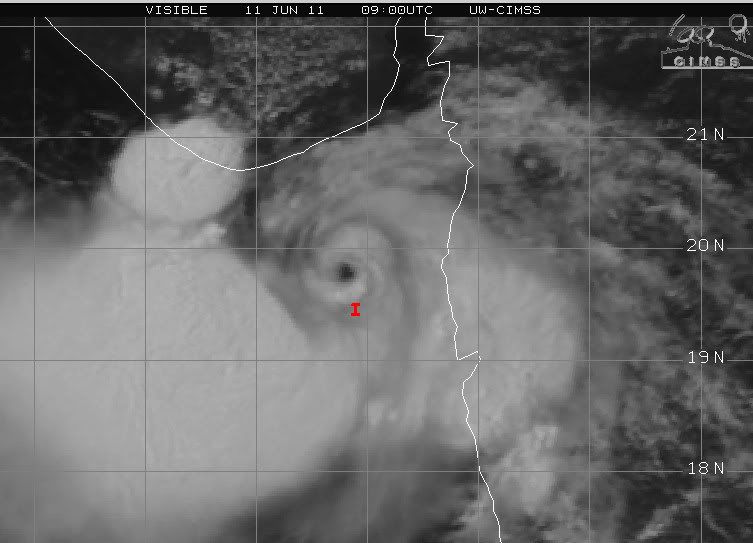
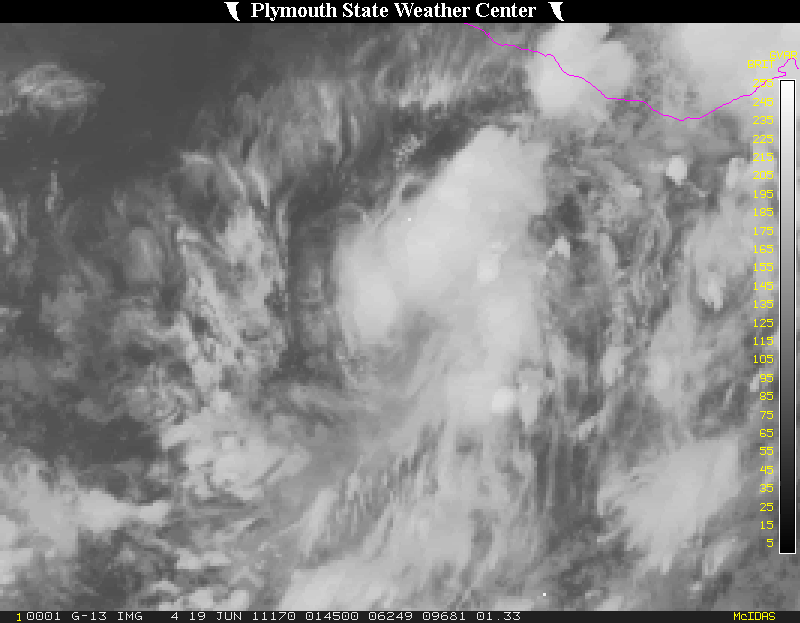
Ik ben benieuwd of dit nog wat gaat worden. Het is nog steeds een high risk en ligt nu al een tijdje op zo'n beetje dezelfde plaats.
Op onderstaande foto lijkt een oog zichtbaar en is draaiing in het systeem te zien.
Op onderstaande foto lijkt een oog zichtbaar en is draaiing in het systeem te zien.
Tropical storm one in de arabische zee. Het is momenteel te vergelijken met een windkracht 8 (Beaufort).
Tropische cycloon one laat in delen van India de regen oplopen tot 200 mm.
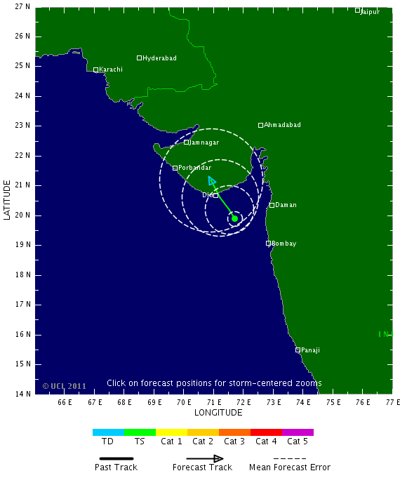
Op de schaal van beaufort is het nu hooguit een windkracht 7. Dit systeem trekt nog langs de westkust en brengt nog veel regen met zich mee
Op de schaal van beaufort is het nu hooguit een windkracht 7. Dit systeem trekt nog langs de westkust en brengt nog veel regen met zich mee
quote:Monsoon Rain to Continue Across India
Vehicles and pedestrians find their way through a waterlogged street as it rains in Mumbai, India, Saturday, June 11, 2011. Heavy rains continued to lash the city for the third consecutive day Saturday, causing floods in several parts of the city. (AP Photo/Rajanish Kakade)
Monsoon moisture will continue to produce localized heavy rain across western India over the next few days.
Aided by the short-lived Tropical Cyclone 01A, localized rain amounts of 3-5 inches (75-125 mm) occurred across northwestern India since Friday.
In the heavily populated city of Mumbai, 1.18 inches (29.9 mm) of rain fell between 8:30 a.m. and 2:30 p.m. on Saturday (local time), while up to 2.63 inches (66.7 mm) of rain fell in the western suburbs.
The heavy rain resulted in standing water on roadways and on some rail lines. Officials also reported numerous down trees across the area.
While the cyclone has dissipated, the remnant swirl will continue to draw very moist, tropical air inland over western India over the next few days.
As is typical for June, daily rainfall amounts of 3-5 inches will occur across western India, while local amounts may near 8 inches (200 mm) in a few locations in the more intense cloud bursts.
Hier kan over een aantal dagen wel iets uitgroeien.
GFS laat een flink windveld langs de Filipijnen gaan.
GFS laat een flink windveld langs de Filipijnen gaan.

Heb de oude topics even aan de reeks toegevoegdquote:Op woensdag 15 juni 2011 23:47 schreef PiRANiA het volgende:
Dit topic is verreekst. Bij een nieuw topic worden volgers meegenomen.

Niet altijd even handig. Ik heb ongeveer 50 topics van de xfactor in mijn myat, waarin ik 1 x heb gepost.quote:
Dit topic is verreekst


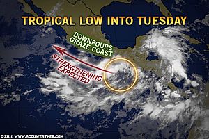
80% nu in de Oost Pacific.
quote:Watching the Eastern Pacific for Tropical Development
"Flash flooding will be possible with these tropical downpours."
The current Infrared satellite imagery courtesy the National Hurricane Center shows a disorganized area of low pressure near the Gulf of Tehuantepac.
The tropical Eastern Pacific is beginning to heat up as an area of low pressure off the coast is becoming better organized.
The area of low pressure is located several hundred miles south of the Gulf of Tehuantepac at the present time.
The latest satellite imagery shows that showers and thunderstorms associated with the system remain disorganized.
However, environmental conditions are currently somewhat favorable for development.
Water temperatures off the southern coast of Mexico are close to 30 degrees celsius or 86 degrees fahrenheit, which is plenty warm for sustaining a tropical system.
The amount of wind shear or change in the winds as you go up in the atmosphere isn't all that strong in the vicinity of the area of low pressure either.
AccuWeather.com meteorologists are forecasting the feature to continue to track toward the northwest the next couple of days, generally paralleling the western coast of Mexico.
Regardless of development, locally drenching showers and thunderstorms will affect coastal locations into early next week. Flash flooding will be possible with these tropical downpours. Residents are urged to turn around and not drive through flooded waters as you never know how deep the water is.
Cities such as Acapulco, Zihuatanejo, and eventually Manzanillo can expect locally flooding downpours as showers and thunderstorms move onshore.
Should the feature strengthen into an organized tropical system, strong wind gusts will become possible, especially with the center of the system being relatively close to the coast.
Residents of the western coast of Mexico should pay attention to this feature and stay tuned to local media outlets for potential tropical watches or warnings should the system develop further.

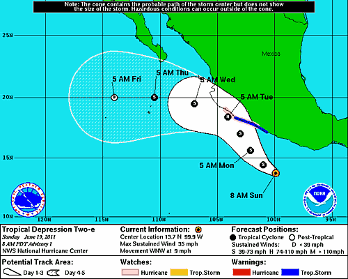
Tropical Depression TWO-E kan flink wat overlast gaan veroorzaken in Mexico.
Volgens onderstaande kaartje gaat deze dicht langs de kust als een categorie 1.
Volgens onderstaande kaartje gaat deze dicht langs de kust als een categorie 1.
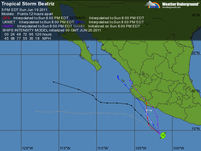
T.D. 2 Becomes Beatriz in the Eastern Pacific
The current Infrared satellite imagery courtesy the National Hurricane Center shows Tropical Storm Beatriz located south of Acapulco.
"Satellite data over the last 12 hours has shown a dramatic increase in thunderstorm activity..."
The tropical Eastern Pacific is heating up as an area of low pressure located about 250 miles south of Acapulco, Mexico has strengthened into Tropical Storm Beatriz Sunday Afternoon.
Satellite data over the last 12 hours has shown a dramatic increase in thunderstorm activity and a gradual organization around the center of the storm.
Water temperatures off the southern coast of Mexico are close to 30 degrees celsius or 86 degrees fahrenheit, which is plenty warm for sustaining a tropical system.
Another variable supportive of development is the amount of wind shear present or "change in the wind direction and speed as you go up in the atmosphere". Wind shear values in the vicinity of the feature are light at the moment and forecasts are for them to stay supportive of further organization.
AccuWeather.com meteorologists are forecasting Beatriz to continue to track toward the northwest the next couple of days, generally paralleling the western coast of Mexico.
The system could strengthen into a hurricane by Tuesday morning not far off the west-central coast of Mexico.
For that reason, a hurricane watch is in effect for the coast of Mexico from Zihuatanejo westward to Manzanillo and a tropical storm warning is in effect for the coast of Mexico from Tecpan De Galeana westward to Punta San Telmo.
Locally drenching showers and thunderstorms will affect coastal locations into early next week. Flash flooding will be possible with these tropical downpours. Residents are urged to turn around and not drive through flooded waters as you never know how deep the water is.
Cities such as Acapulco, Zihuatanejo, and eventually Manzanillo can expect locally flooding downpours as bands of showers and thunderstorms move onshore.
Along with the torrential downpours, strong wind gusts will become likely as the system strengthens and parallels the coastline.
Residents of the western coast of Mexico should pay attention to this feature and stay tuned to local media outlets for additional tropical watches or warnings.
Bron: Accuweather

The current Infrared satellite imagery courtesy the National Hurricane Center shows Tropical Storm Beatriz located south of Acapulco.
"Satellite data over the last 12 hours has shown a dramatic increase in thunderstorm activity..."
The tropical Eastern Pacific is heating up as an area of low pressure located about 250 miles south of Acapulco, Mexico has strengthened into Tropical Storm Beatriz Sunday Afternoon.
Satellite data over the last 12 hours has shown a dramatic increase in thunderstorm activity and a gradual organization around the center of the storm.
Water temperatures off the southern coast of Mexico are close to 30 degrees celsius or 86 degrees fahrenheit, which is plenty warm for sustaining a tropical system.
Another variable supportive of development is the amount of wind shear present or "change in the wind direction and speed as you go up in the atmosphere". Wind shear values in the vicinity of the feature are light at the moment and forecasts are for them to stay supportive of further organization.
AccuWeather.com meteorologists are forecasting Beatriz to continue to track toward the northwest the next couple of days, generally paralleling the western coast of Mexico.

The system could strengthen into a hurricane by Tuesday morning not far off the west-central coast of Mexico.
For that reason, a hurricane watch is in effect for the coast of Mexico from Zihuatanejo westward to Manzanillo and a tropical storm warning is in effect for the coast of Mexico from Tecpan De Galeana westward to Punta San Telmo.
Locally drenching showers and thunderstorms will affect coastal locations into early next week. Flash flooding will be possible with these tropical downpours. Residents are urged to turn around and not drive through flooded waters as you never know how deep the water is.
Cities such as Acapulco, Zihuatanejo, and eventually Manzanillo can expect locally flooding downpours as bands of showers and thunderstorms move onshore.
Along with the torrential downpours, strong wind gusts will become likely as the system strengthens and parallels the coastline.
Residents of the western coast of Mexico should pay attention to this feature and stay tuned to local media outlets for additional tropical watches or warnings.
Bron: Accuweather
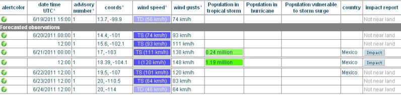
Kaartje van gdacs (Global Disaster Alert and Coordination System) laat zien dat meer dan een miljoen mensen problemen kunnen krijgen door deze tropische storm.
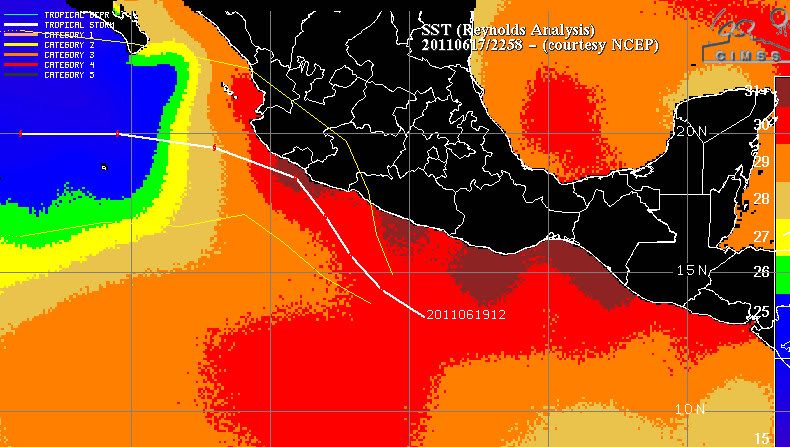
De route van Beatriz gaat over water dat rond de 30 graden ligt. Dichter bij de kust komt ze zelfs in water warmer dan 30 graden terecht.
De route van Beatriz gaat over water dat rond de 30 graden ligt. Dichter bij de kust komt ze zelfs in water warmer dan 30 graden terecht.
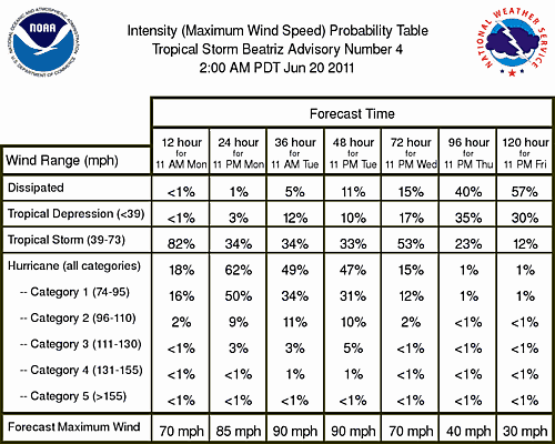
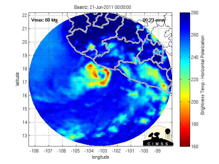
Beatriz is een Tropische storm met een windsnelheid (74 km/uur, windstoten tot 92 km/uur) die te vergelijken is met bijna een windkracht 9 op de schaal van Beaufort. De storm neemt langzaam in kracht toe en zal waarschijnlijk morgen de orkaan status halen.
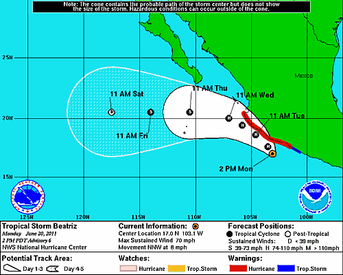
Een aantal modellen laten de storm aan land gaan bij Mexico.
Een aantal modellen laten de storm aan land gaan bij Mexico.
De tropische storm is nu te vergelijken met een windkracht 11 op de Beaufort schaal. De windstoten schieten uit tot zo'n 120 km/uur. De storm verplaatst zich met een snelheid van 14 km/uur in Noordwestelijke richting en heeft een luchtdruk van 995 mb. Delen van de westkust hebben inmiddels last van de regen van deze storm, die dicht langs de kust gaat trekken.
Voor een deel van de westkust is een hurricane warning afgegeven.
Voor een deel van de westkust is een hurricane warning afgegeven.
Beatriz is opgehoogd naar een categorie 1 met windsnelheden tot 144 km/uur. De kust wordt bovendien geteisterd door windstoten die oplopen tot 185 km/uur. Ook heeft het land (tot ver in het binneland) te maken met veel neerslag.
De kerndruk is teruggelopen naar 977mb.
De orkaan scheert precies langs de westkust van Mexico en zal vervolgens afbuigen richting het westen.
De kerndruk is teruggelopen naar 977mb.
De orkaan scheert precies langs de westkust van Mexico en zal vervolgens afbuigen richting het westen.
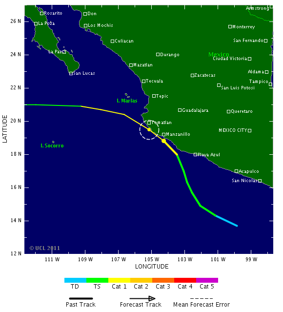
Het is nu nog net een categorie 1 orkaan (windsnelheid 128 km/uur en stoten tot 152 km/uur). Het oog van deze orkaan heeft net de kust van Mexico aangeraakt.
Die volgt ook zowaar de hele strook  bizar om dat te zien.
Doe mee met het voorspellen van het weer!
Weekvoorspelling | Week 12 (invullen tot 16-03 - 11:59)
Maandvoorspelling Maart (Inzendingen gesloten)
Jaarvoorspelling 2025 / 2026
Weekvoorspelling | Week 12 (invullen tot 16-03 - 11:59)
Maandvoorspelling Maart (Inzendingen gesloten)
Jaarvoorspelling 2025 / 2026
Lijkt apart inderdaad. Het oog komt net een (klein)stuk over het land.quote:Op dinsdag 21 juni 2011 21:49 schreef SpeedyGJ het volgende:
Die volgt ook zowaar de hele strook

Inmiddels vier doden aldus het nieuws.quote:Beatriz kills 3 in Acapulco
The second Pacific hurricane of 2011 brought high winds and heavy rains to beach resorts from Zihuatanejo to Cabo Corrientes, forcing thousands of tourists to hole up in their hotels as it uprooted trees and flooded roads.
In Acapulco, the main port on Mexico's Pacific coast and a popular tourist spot, three members of the same family drowned after falling into a septic tank while trying to rescue two women, public safety officials said.
Another person was reported missing and dozens of homes were seriously damaged. "Undoubtedly, Acapulco was the hardest hit," said Guerrero state public safety spokesman Ramon Almonte.
Top winds of 80 miles per hour died down by Tuesday afternoon to 60 miles per hour and Beatriz was forecast to track into the Pacific and fizzle out.
"There are no coastal watches or warnings in effect," the US National Hurricane Center in Miami reported.
The western state of Jalisco was also hit hard by the storm, with heavy rain recorded in Tomatlan, Cabo Corrientes, La Huerta and Puerto Vallarta, another of Mexico's biggest tourist destinations.
Red flags dotted the beaches to keep swimmers out of the high seas and local authorities urged caution when driving through mountainous interior roads due to the risk of landslides.
The 2011 storm season is expected to be worse than usual, US experts have said. Adrian, the first Pacific hurricane of the 2011 season, was downgraded to a tropical storm over a week ago and never made landfall.
Was de landfall anders dan? Volgens kaartje hierboven bleef hij aardig uit de buurt van Acapulco?


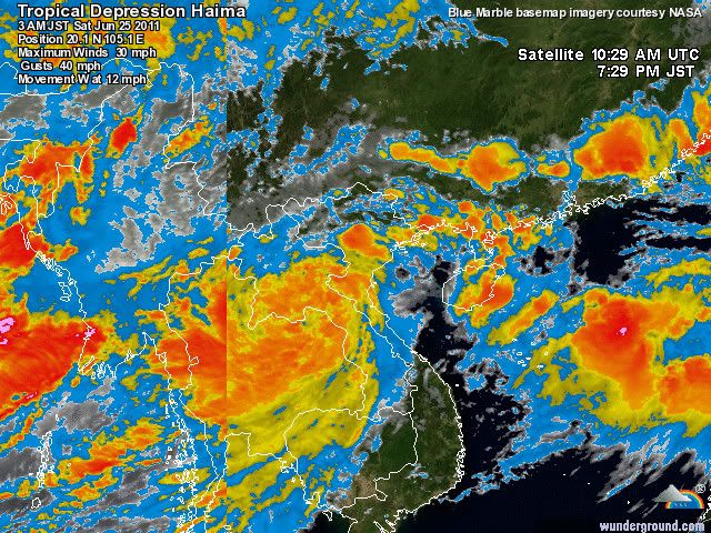
Zeven doden en vier vermisten na tropische storm in Vietnam
De doortocht van de tropische storm Haima in het noorden van Vietnam heeft aan minstens zeven mensen het leven gekost. Vier anderen worden nog steeds vermist. Dat melden de autoriteiten.
Onder de dodelijke slachtoffers bevonden zich een zwangere vrouw, drie kinderen en een visser. De acht maanden zwangere vrouw kwam om het leven door een vallende boom in de havenstad Hai Phong. De twee kinderen van 4 en 9 jaar oud kwamen door de sterke wind in de rivier Nghe An terecht. In de provincie Yen Bai werden vier vissers verrast door een vloedgolf. Eén lichaam werd al teruggevonden. (dpa/svm)
hln
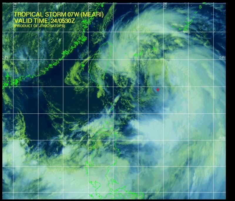
Meari
Het is een vrij groot systeem. Nu te vergelijken met net een windkracht 10(beaufort) waarbij windstoten voorkomen tot 120 km/uur.
Meari lijkt nog in kracht toe te nemen tot een categorie 1 en is op weg naar zuid en noord Korea.
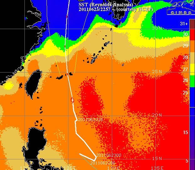
Op onderstaande kaartje is te zien dat de storm nog over warm water trekt, maar vervolgens in steeds kouder water terecht komt. Hierdoor zal de kracht afnemen.
Het is een vrij groot systeem. Nu te vergelijken met net een windkracht 10(beaufort) waarbij windstoten voorkomen tot 120 km/uur.
Meari lijkt nog in kracht toe te nemen tot een categorie 1 en is op weg naar zuid en noord Korea.
Op onderstaande kaartje is te zien dat de storm nog over warm water trekt, maar vervolgens in steeds kouder water terecht komt. Hierdoor zal de kracht afnemen.
Tienduizenden geëvacueerd na tropische storm op Filipijnen
Op de Filipijnen werden bijna 50.000 mensen geëvacueerd wegens overstromingen na de doortocht van de tropische storm Meari.
In de hoofdstad Manilla verlieten meer dan 3.200 mensen hun huizen terwijl talloze straten onder water stonden. De snelle evacuaties in de hoofdstad hebben ervoor gezorgd dat daar geen dodelijke slachtoffers te betreuren zijn, zo luidt het.
Op het schiereiland Bicol, ten zuidoosten van Manilla, worden echter 11 mensen, onder wie 10 vissers, nog steeds vermist. Meer dan 42.000 geëvacueerden werden ondergebracht in opvangcentra op het schiereiland. (belga/lb)
bron
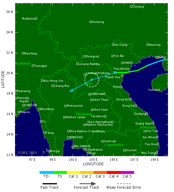
Haima zorgt nog steeds voor veel neerslag in Vietnam. Ook de wind, die te vergelijken is met een windkracht 8 (beaufort) speelt nog een rol. De windstoten lopen op tot zo'n 84 km/uur.
Ook het buurland Laos, kan nog rekenen op een flinke hoeveelheid neerslag.
In Vietnamese media wordt nu gesproken over 10 doden en 80 gewonden. Duizenden huizen zijn beschadigd.
Ook het buurland Laos, kan nog rekenen op een flinke hoeveelheid neerslag.
In Vietnamese media wordt nu gesproken over 10 doden en 80 gewonden. Duizenden huizen zijn beschadigd.
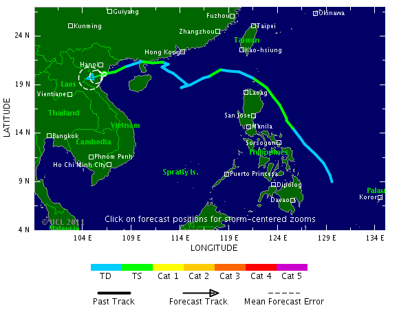
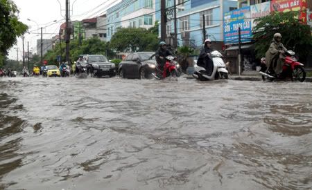
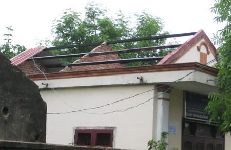

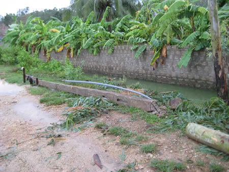
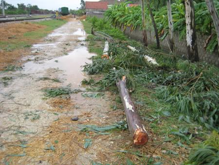
Volgens Vietnamese media zijn er inmiddels 13 doden, 4 vermisten en 60 gewonden in Vietnam. Veel huizen zijn beschadigd en enkele zijn ingestort. Op sommige plaatsen is meer dan 300 mm regen gevallen. Ook zijn enkele vissersboten beschadigd.
Rijstvelden in Vietnam staan onder water.
De storm kan zelfs voor overlast gaan zorgen in Thailand.
Rijstvelden in Vietnam staan onder water.
De storm kan zelfs voor overlast gaan zorgen in Thailand.