WKN Weer, Klimaat en Natuurrampen
Lees alles over het onstuimige weer op onze planeet, volg orkanen en tornado's, zie hoe vulkanen uitbarsten en hoe Moeder Aarde beeft bij een aardbeving. Alles over de verwoestende kracht van onze planeet en tal van andere natuurverschijnselen.


Orkaan Tomas: Bedreiging voor Haiti?
Orkaan Tomas is op weg naar de Caribische zee, waar het zal uitgroeien tot een categorie 3 orkaan. Waarschijnlijk buigt de orkaan af richting Haiti/Dominicaanse Republiek. Dit zal een nieuwe ramp betekenen voor Haiti.
Plaats hier al het nieuws over Orkaan Tomas
Zie ook:
Hurricane Season 2010 # 3
Haïti: voorbereiden op het ergste: Cholera en een nieuwe beving
Orkaan Tomas is op weg naar de Caribische zee, waar het zal uitgroeien tot een categorie 3 orkaan. Waarschijnlijk buigt de orkaan af richting Haiti/Dominicaanse Republiek. Dit zal een nieuwe ramp betekenen voor Haiti.
Plaats hier al het nieuws over Orkaan Tomas

quote:Curaçao, Bonaire en Aruba klaar voor tropische storm
WILLEMSTAD - Curaçao bereidt zich voor op de tropische storm Tomas. Dat verklaarde minister-president Gerrit Schotte vrijdagavond op een ingelaste persconferentie in Willemstad.
Tomas zal naar verwachting in de nacht van zondag op maandag (lokale tijd) op ongeveer 250 km ten noorden van Bonaire, Curaçao en Aruba passeren. Dit zal gepaard gaan met hevige buien en veel wind.
Schotte verklaarde dat de draaiboeken van het rampenteam in werking zijn gesteld. Dat betekent onder meer dat de shelters in staat van paraatheid worden gebracht en vissers wordt aangeraden de zee te mijden.
Ook op de andere eilanden wordt de ontwikkeling van Tomas nauwgezet in de gaten gehouden. Voor een aantal Caraïbische eilanden is een orkaanwaarschuwing uitgevaardigd. Het Amerikaanse Orkaancentrum verwacht dat Tomas zal uitgroeien tot een sterke orkaan van vierde categorie.
© ANP
nu.nl
Zie ook:
Hurricane Season 2010 # 3
Haïti: voorbereiden op het ergste: Cholera en een nieuwe beving

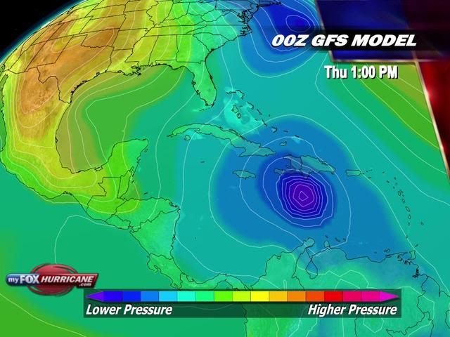
Kaartje voor donderdag laat zien dat Tomas dicht bij Haiti/Dominicaanse Republiek ligt.
Tomas is bijna een cat1. Nu nog een windsnelheid van 112 km/uur met windstoten tot 136 km/uur.
Tomas is bijna een cat1. Nu nog een windsnelheid van 112 km/uur met windstoten tot 136 km/uur.
Hurricane Could Take Aim at Haiti
|
"Tomas" will take center stage in the Caribbean, threatening populated areas and perhaps making a bad situation in Haiti much worse.
While people on the Leewards, the Virgin Islands and Puerto Rico may be able to breathe a sigh of relief, concerns are shifting farther to the south and west in the Caribbean.
This weekend, Tomas will unload heavy rainfall over the Windwards, Trinidad and Tobago, Venezuela and the small islands bordering the Cariaco and Bonaire basins.
Locales in this region may be hit with rainfall rates of up to several inches per hour, unleashing flash flooding, washouts and mudslides. Rough seas will endanger small craft and fishing interests.
Close proximity to South America will interfere with the strength of Tomas this weekend. However, AccuWeather.com meteorologists have great concerns beyond the weekend.
The overall large size of the feature may allow it to persevere as it navigates the northern edge of the large land mass.
During the first part of next week, there are indications Tomas may drift into the open waters of the central Caribbean. This would prop the door wide open for rapid intensification.
Possible paths next week range from a direct strike on Haiti to a farther west path toward Jamaica or even Central America. It appears the westerlies would prevent a strike on the U.S.
It would be a horrible scenario if Tomas were to turn to the north and slam Haiti as a hurricane. Unfortunately, that is at least a possibility at this point.
After being devastated by a powerful earthquake last winter, cholera is now claiming lives in Haiti. Even a glancing blow from a hurricane or a brush with a tropical storm could lead to catastrophe from flash flooding and mudslides.
It would also be ironic, as Haiti has dodged many bullets from the tropics this season, only to be hit by possibly the last hurricane of the 2010 Atlantic season.
Hurricane season does not officially end until November 30, but it may be tough to get a system up to hurricane strength beyond next week.
Accuweather
|
"Tomas" will take center stage in the Caribbean, threatening populated areas and perhaps making a bad situation in Haiti much worse.
While people on the Leewards, the Virgin Islands and Puerto Rico may be able to breathe a sigh of relief, concerns are shifting farther to the south and west in the Caribbean.
This weekend, Tomas will unload heavy rainfall over the Windwards, Trinidad and Tobago, Venezuela and the small islands bordering the Cariaco and Bonaire basins.
Locales in this region may be hit with rainfall rates of up to several inches per hour, unleashing flash flooding, washouts and mudslides. Rough seas will endanger small craft and fishing interests.
Close proximity to South America will interfere with the strength of Tomas this weekend. However, AccuWeather.com meteorologists have great concerns beyond the weekend.

The overall large size of the feature may allow it to persevere as it navigates the northern edge of the large land mass.
During the first part of next week, there are indications Tomas may drift into the open waters of the central Caribbean. This would prop the door wide open for rapid intensification.
Possible paths next week range from a direct strike on Haiti to a farther west path toward Jamaica or even Central America. It appears the westerlies would prevent a strike on the U.S.

It would be a horrible scenario if Tomas were to turn to the north and slam Haiti as a hurricane. Unfortunately, that is at least a possibility at this point.
After being devastated by a powerful earthquake last winter, cholera is now claiming lives in Haiti. Even a glancing blow from a hurricane or a brush with a tropical storm could lead to catastrophe from flash flooding and mudslides.
It would also be ironic, as Haiti has dodged many bullets from the tropics this season, only to be hit by possibly the last hurricane of the 2010 Atlantic season.
Hurricane season does not officially end until November 30, but it may be tough to get a system up to hurricane strength beyond next week.
Accuweather

Hurricane Tomas Damaging Windward Islands
Hurricane Tomas is leaving a trail of damage across the Windward Islands.
Due to Hurricane Tomas, the government of St. Lucia has closed all businesses as well as two airports. The island's biggest Creole festival was called off by the organizer as well, due in part to the storm.
The National Hurricane Center has reported sustained winds of 48 mph and a gust of 69 on the island of St. Lucia.
According to the Associated Press, a school and a hospital had their roofs torn off by the wind.
Down power lines and trees were in the streets.
Recent reports from Ham Radio Operators indicate widespread damage to power lines and homes across Barbados.
"The island of Barbados had a wind gust of 56 mph," said AccuWeather.com Senior Meteorologist, Kristina Pydynowski. "Barbados had 3.05 inches of rain in the past 24 hours that ended at 8:00 a.m. EDT," she said.
The National Hurricane Center also reported a wind gust of 51 mph on the island of Martinique.
Tomas is expected to cross into the eastern Caribbean Sea by Saturday night. There is concern that Tomas will eventually take aim at Haiti.
bron
Orkaan Tomas koerst af op Haïti
De Verenigde Naties vrezen dat Haïti getroffen wordt door de orkaan Tomas. De storm koerst de komende dagen naar het land, dat in januari getroffen werd door een zware aardbeving. Anderhalf miljoen mensen wonen er nog in tentenkampen.
Momenteel heerst er in Haïti een cholera-epidemie en volgens de VN is een orkaan wel het laatste dat het land momenteel kan gebruiken.
De storm passeerde enkele eilanden, waaronder Saint Lucia en Saint Vincent. Daar werden daken, elektriciteitsdraden en bomen vernield. Over slachtoffers is nog niets bekend. Tomas zal aan Bonaire, Aruba en Curacao ruim voorbijgaan.
NOS
Cat 2quote:Op zondag 31 oktober 2010 11:45 schreef Disorder het volgende:
Cat. hoeveel nu? Waar vind ik dat online?
http://www.tropicalstormrisk.com/
http://www.wunderground.com/tropical/
Het ziet er niet goed uit voor Haiti
Momenteel is Tomas weer een categorie 1 met een maximum windsnelheid van 144 km/uur en windstoten tot 185 km/uur.
[ Bericht 0% gewijzigd door #ANONIEM op 31-10-2010 18:42:51 ]
Momenteel is Tomas weer een categorie 1 met een maximum windsnelheid van 144 km/uur en windstoten tot 185 km/uur.

[ Bericht 0% gewijzigd door #ANONIEM op 31-10-2010 18:42:51 ]
Tomas gaat nog verder afzwakken tot Tropische storm en zal na een paar dagen weer activeren tot orkaan. Zoals het nu staat zal deze orkaan als categorie 2, landfall maken op Haiti.
Hurricane Tomas dealt a punishing blow to the Caribbean island of St. Lucia, with the neighboring islands of St. Vincent, Dominica, and Barbados also suffering heavy damage. St. Lucia received the full brunt of the northern eyewall of Tomas as it intensified into a Category 2 hurricane with 100 mph winds early this morning. The St. Lucia weather service reported that sustained winds of 90 - 95 mph affected the island. A state of emergency has been declared on the island, and there are island-wide power outages on both St. Lucia and Dominica. Heavy flooding affected St. Lucia, washing out many bridges, and the airport is closed due to flooding. Damage to structures is considerable, with many roofs gone, and damage reported to hospitals, schools, and businesses.
[img]http://img.photobucket.com/albums/v628/halloa/tomas_stlucia.jpg[/img]
Tomas significantly weakens
An Air Force hurricane hunter aircraft arrived at Tomas at 2pm this afternoon, and found a much weaker storm. The 2pm EDT center fix found that the pressure has risen to 994 mb, and the strongest surface winds were barely Category 1 hurricane strength, 74 mph. The aircraft found the the eyewall had mostly collapsed. Satellite loops of Tomas also show a significant degradation in the appearance of the storm in recent hours. The storm is highly asymmetric with very little heavy thunderstorm activity or upper level outflow on the west side, and the hurricane has only one prominent spiral band, on the east side. Wind shear is a high 20 knots due to strong upper level west-southwest winds, and these winds are driving dry air at mid-levels of the atmosphere into Tomas' west side, as seen on water vapor satellite imagery.
Track forecast for Tomas
The ridge of high pressure pushing Tomas to the west-northwest will weaken by Tuesday, as a trough of low pressure approaches the eastern U.S. and breaks down the ridge. This will result in Tomas slowing from its current 9 mph forward speed to 5 mph by Tuesday. By Thursday, the trough to Tomas' north should be able to pull the storm to the north. The exact timing and location of this turn is still very uncertain. The computer model solutions from the latest set of 8am EDT (12Z) runs include a strike on Haiti on Friday (GFS and GFDL models), a strike on the Dominican Republic on Friday (NOGAPS model), a strike on Haiti on Saturday (UKMET model), a strike on Jamaica and eastern Cuba on Thursday (Canadian), or a strike on Puerto Rico on Friday (HWRF).
Intensity forecast for Tomas
Wind shear is forecast to remain in the high range, 20 - 25 knots, through Monday night, then decline to the moderate range, 10 - 20 knots, for the remainder of the week. Tomas will struggle with the shear and the dry air to its west through Tuesday, and I expect it will weaken to a tropical storm tonight, and remain a tropical storm until Tuesday, when the shear finally relents. At that point, re-intensification is likely, though with the storm's inner core gone, I expect it will take Tomas two days before it can re-establish a complete eyewall. Hindering that process will be the slow motion of the storm, which will allow cooler waters from the depths upwell to the surface and cool the SSTs. Still, the waters are very warm in the Caribbean and these waters extend to great depth, so the upwelling cool water may not impede intensification as much as might ordinarily be expected. The intensity Tomas might have as landfall in Hispaniola or Jamaica is highly uncertain, and a strength anywhere between a tropical storm and Category 3 hurricane would not be surprising. The HWRF model predicts Tomas will be a borderline tropical storm/Category 1 hurricane on Friday, while the GFDL foresees Tomas will be a strengthening Category 3 hurricane as it bears down on Haiti Friday afternoon. I predict Tomas will have trouble reorganizing, and will be a strengthening Category 1 hurricane on Friday as it makes landfall in Haiti or the Dominican Republic.
[ Bericht 1% gewijzigd door #ANONIEM op 31-10-2010 22:12:51 ]
Tomas Weakens; Will Be More Dangerous Later This Week
[ Bericht 1% gewijzigd door #ANONIEM op 31-10-2010 22:41:51 ]
quote:Tomas is weakening, but there is growing concern that the hurricane will regain strength and target Haiti later this week.
Tomas tore through the Windward Islands on Saturday, strengthening in the process and leaving a trail of damage.
Tomas was a Category 2 hurricane as it battered the Windward Islands Saturday night. Disruptive wind shear (strong wind shear high in the atmosphere) has since caused Tomas to weaken into a minimal Category 1 hurricane.
Tomas could weaken further into a tropical storm over the next day or two.
The AccuWeather.com Hurricane Center has the latest statistics on Tomas, including its current location and intensity.
The wind shear is also causing rain squalls associated with Tomas to stream eastward over the Lesser Antilles, hampering cleanup efforts in Tomas' wake.
The disruptive wind shear will lessen at midweek, opening the door for Tomas to strengthen into a major hurricane with maximum sustained winds of at least 111 mph.
Later in the week, there is growing concern that Tomas will deviate off its westward track and target Hispaniola (the island that Haiti and the Dominican Republic call home). Tomas may even take aim at Hispaniola after first bypassing the island to the south.
As stated by AccuWeather.com Expert Senior Meteorologist Alex Sosnowski, "It would be a horrible scenario if Tomas were to turn to the north and slam Haiti as a hurricane." Haiti has yet to recover from the devastating January earthquake and is now fighting a cholera epidemic.
Tomas will be forced to curve towards Haiti by the jet stream, which is expected to sink southward and usher a reinforcing shot of chilly air across the East later in the week. Another scenario is that Tomas makes that curve, but targets Jamaica or Cuba.
The hurricane would take a track towards Central America if it misses the connection with the jet stream; however, this solution is becoming less likely.

[ Bericht 1% gewijzigd door #ANONIEM op 31-10-2010 22:41:51 ]
Oei. Kan dus link worden voor Haiti. Rampscenario. Eerst die aardbeving, dan cholera en dan een orkaan 
Inmiddels dus weer gedowngrade tot een tropische storm, maar mogelijk weer Cat.1 orkaan voordat Haiti wordt getroffen.quote:Orkaan Tomas trekt door Caraiben
De orkaan Tomas is in de nacht van zaterdag op zondag opgeklommen in de hiërarchie en valt nu onder categorie 2 van de schaal van Saffir-Simpson die 5 categorieën telt.
Volgens het Nationaal Orkaan Centrum (NHC) in Miami ontwikkelt Tomas windsnelheden van 160 km per uur. Het natuurgeweld trekt richting Jamaïca, Cuba, Haïti en de Dominicaanse Republiek. Tevoren deed Tomas de tot de Kleine Antillen behorende Benedenwindse Eilanden aan, waar veel schade is aangericht.
Zware regenval
Tomas is zaterdag in het westen van de Atlantische Oceaan ontstaan. De orkaan trakteerde de eilandgroep die de Atlantische Oceaan van de Caraïben scheidt op sterke regenval en windsnelheden tot 120 km per uur. Ook op Saint-Vincent en de Grenadines, Saint-Lucia, Dominica en Martinique was er schade. De orkaan rukte daken af en ontwortelde bomen.
Zaterdag bevond het centrum van de orkaan zich midden de Caraïben en bewoog langzaam naar het noordwesten. Midden volgende week zou Tomas het eiland Hispaniola met Haïti en de Dominicaanse Republiek bereiken. Metereologen waarschuwen vooral voor regenval aldaar en op Jamaïca.
Valt op zich mee, maar ik ga er vanuit dat er daar nog aardig wat in gammele gebouwtjes en tenten wonen, dus dan is alles eigenlijk te veel 
Tomas gaat in een slakkegangetje verder en zet net voor Jamaica koers richting Haiti.(als een cat 1)

quote:Orkaan Tomas eist levens op Curacao
De nasleep van orkaan Tomas heeft op Curaçao aan twee mensen het leven gekost. Een reddingswerker die bezig was met evacueren is overleden. Daarnaast overleed een ouder persoon aan een hartaanval.
Onbekend is nog of die persoon een man of vrouw is. De reddingswerker van Citro is vermoedelijk omgekomen tijdens de evacuatie van het Advent Ziekenuis op Groot Davelaar. Een muur kwam naar beneden, wat de reddingswerker waarschijnlijk fataal werd. Achttien patiënten zijn geëvacueerd.
Wateroverlast
Curaçao kampt met veel wateroverlast door orkaan Tomas. Huizen staan blank, beerputten zijn overgelopen, meubels drijven weg in de tuin. Op sommige delen van het eiland is de stroom uitgevallen.
De scholen zijn vandaag dicht, op gezag van premier Gerrit Schotte. Later op de ochtend houdt de premier een persconferentie over de actuele stand van zaken. In Willemstad zouden extra shelters geopend zijn voor de slachtoffers van de wateroverlast.
Weeralarm
Gisteravond, 1 november, werd het avondverkeer verrast door het noodweer. In korte tijd viel 40 milimeter regen, waardoor het wegennet onbegaanbaar werd. Sommige automobilisten spoelden van de weg. De meteorologische dienst gaf tot 03.00 uur een weeralarm af, maar het regent nog steeds op Curaçao.
Aruba had eerder op de dag, 1 november, last van wateroverlast en ook Bonaire heeft last van orkaan Tomas gehad. Op dit moment is er motregen op Aruba en Bonaire en is het relatief rustig.

14 doden op st Lucia en er worden nog mensen vermist. 1200 huizen zijn beschadigd en er staat geen bananen boom meer overeind op de noordkant van het eiland. Waarschijnlijk wordt Tomas van de lijst afgehaald en zal niet meer terugkeren als naam van een orkaan.
Volgens het laatste plaatje gaat de orkaan als een categorie2 Haiti treffen.
[ Bericht 2% gewijzigd door #ANONIEM op 02-11-2010 18:46:05 ]
Volgens het laatste plaatje gaat de orkaan als een categorie2 Haiti treffen.
quote:The islands of St. Lucia, Barbados, and St. Vincent and the Grenadines continue to assess damage and clean up after Hurricane Tomas pounded the Lesser Antilles as a strengthening Category 1 hurricane with 90 - 95 mph winds on Saturday. St. Lucia was hardest hit, with fourteen people dead, many more missing, and damage estimated at $100 million--about 10% of the nation's GDP. Damage on neighboring St. Vincent was estimated at $62 million, which is 4% of that nation's GDP. The storm damaged 1,200 houses, and the northern half of the island, where most of the crops are, was badly hit, with no banana trees left standing and the plantain crop wiped out. Banana production employs 60% of the workforce on St. Vincent, and accounts for more than 50% of their exports. Also hard-hit was Barbados, where damage estimates are at $55 million, 1.5% of the nation's GDP. Tomas may be the most damaging storm to affect the island since Hurricane Janet of 1955. The havoc wreaked by Tomas in the Lesser Antilles makes is likely that the name Tomas will be retired from the list of active hurricane names in the Atlantic.
[ Bericht 2% gewijzigd door #ANONIEM op 02-11-2010 18:46:05 ]
Haiti kan getroffen worden door een enorme hoeveelheid regen. Men heeft het al over 300 mm, mocht de orkaan vertragen dan kan dit weleens het dubbele worden. Donderdag krijgt het zuiden van Haiti al te maken met de eerste verschijnselen van de orkaan.
quote:Tomas Could Hit Haiti with Devastating 1 to 2 Feet of Rain
.
Haiti has had a devastating year with the earthquake and a more recent cholera outbreak. This video has the details on how Haiti has been affected and takes a look at what the worst case scenario would be for the nation with Tomas.
The AccuWeather.com Hurricane Center is still forecasting Tomas to slam into earthquake-ravaged Haiti as a hurricane late this week, bringing yet another disastrous blow to the impoverished nation.
While powerful winds are certainly a major concern for the more than 1 million people still living in makeshift shelters, it's Tomas' flooding rain that will be the greatest threat to life and ultimately the biggest disaster since January's earthquake.
The storm is currently predicted to make landfall as a Category 1 hurricane over Haiti Friday. Even if the center of Tomas were to track completely west of Haiti without a landfall, it will still impact the nation with flooding rain.
Given its expected track, speed and intensity, AccuWeather.com Expert International Forecaster Jim Andrews advises that rainfall on the order of 2 to 4 inches is likely in Haiti's capital city of Port-au-Prince, where an estimated 1.3 million residents displaced by the earthquake are living in tents and under tarps.
Rainfall on this order in the city alone will be enough to cause flooding and create a mess for these people.
To make matters worse, rainfall totals in the mountains that border Port-au-Prince to the south and southeast will be even higher, ranging from 4 to 8 inches or more, and will result in significant runoff down the slopes and into the city as well as surrounding populated areas.
Tomas is expected to start bringing increasing winds and rain to Haiti's southern coast late Thursday before making landfall Friday.
What has AccuWeather.com meteorologists even more concerned is the potential for Tomas to track more slowly across Haiti than currently expected. Slower movement could easily lead to double the rainfall.
In other mountainous areas of Haiti where Tomas' winds flow uphill, especially across the south, rainfall totals will be on the order of a foot or more regardless of the storm's speed.
Adding to an already disastrous situation is the fact that widespread deforestation has taken place across Haiti. On exposed slopes, runoff will be quicker, more significant and carry with it mud, rocks and other debris that will cover anything in its path.
This threat applies at least to part of the area that drains into Port-au-Prince.
As for winds, it may only take minimal tropical storm-force gusts to destroy makeshift shelters earthquake victims are living in. The current forecast track brings Tomas west of Port-au-Prince. If it passes close enough, this track will put the city in the right, front quadrant of the storm with the strongest winds.
Andrews says that even if the earthquake had never hit Haiti in January, Tomas on its own would be a disaster for the nation given the current expectations for the storm.
Damdoorbraken in Curaçao door storm Tomas
(Novum) - Op Curaçao zijn meerdere dammen doorgebroken als gevolg van de storm Tomas. Vooralsnog heeft dit niet tot grote problemen geleid, laat een woordvoerder van het Meteorologische instituut op Curaçao weten. Onder meer een dam in Stenen Koraal is doorgebroken.
Berichten over plunderingen door eilandbewoners worden door een zegsman van de politie weersproken. Volgens hem is er een etalageruit gesneuveld, maar werd niets meegenomen. De politie stelt dat de situatie onder controle is.
Eerder werd bekend dat tijdens het noodweer in ieder geval twee mensen om het leven zijn gekomen. Ook zijn er berichten over een derde dode. De politie kan dit niet bevestigen. Onduidelijk is hoe groot de schade op de eilanden is. Het Nederlandse leger is om bijstand gevraagd.
Tomas, die nu een tropische storm is, beweegt zo'n driehonderd kilometer ten noorden van de ABC-eilanden in noordwestelijke richting richting Haïti. De woordvoerder verwacht dat de tropische storm mogelijk woensdag weer tot orkaankracht toeneemt. Tomas buigt dan nog meer in noordwestelijke richting af.
Ondanks de heftige regenval is er volgens de woordvoerder de afgelopen 24 uur geen regenrecord gebroken. In 1970 viel er 287 millimeter, terwijl er dinsdag tot 08.00 uur (lokale tijd) 265 millimeter neerslag viel. De meeste regen viel in het oostelijke deel van Curaçao.
nieuws.nl
De koers is iets veranderd. Tomas trekt nu, met een snelheid van 9 a 10 kilomter/uur, tussen Haiti en Cuba door.
De storm is nu te vergelijken met een windkracht 9 waarbij windstoten voorkomen tot 104 km/uur. De verwachting is dat Tomas zal toenemen tot orkaankracht.De kerndruk is momenteel 997 mb
[ Bericht 1% gewijzigd door #ANONIEM op 04-11-2010 12:36:17 ]
De storm is nu te vergelijken met een windkracht 9 waarbij windstoten voorkomen tot 104 km/uur. De verwachting is dat Tomas zal toenemen tot orkaankracht.De kerndruk is momenteel 997 mb
[ Bericht 1% gewijzigd door #ANONIEM op 04-11-2010 12:36:17 ]
Geen Landfall op Haiti, maar er blijft een gevaar voor overstromingen en modderstromen. Mede door de houtkap op het eiland is het gevaar voor aardverschuivingen etc groot.
quote:Haiti Faces Life-Threatening Flooding from Tomas
Flooding rain accompanying Tropical Storm Tomas threatens to bring another disastrous blow to Haiti tonight into Friday.
The AccuWeather.com Hurricane Center expects Tomas to pass through the Windward Passage, which separates Cuba and Haiti, tonight into Friday. Tomas should strengthen through this time, regaining Category 1 hurricane status.
The AccuWeather.com Hurricane Center gives the latest statistics on Tomas, including its location and intensity.
Even though Tomas is not expected to make a direct landfall on Haiti, torrential rainfall will still spread over the nation and neighboring parts of the Dominican Republic.
After the rain arrives today, the potential exists for over a foot of rain to fall in the mountainous areas of these two nations. Disastrous flash flooding and mudslides are sure to result in and below the hillsides.
AccuWeather.com Meteorologist Heather Buchman reported that "Adding to an already disastrous situation is the fact that widespread deforestation has taken place across Haiti."
Buchman went on to say that "On exposed slopes, runoff will be quicker, more significant and carry with it mud, rocks and other debris that will cover anything in its path."
With Tomas expected to remain offshore, the zone of torrential rain and damaging winds will now expand and encompass the eastern tip of Cuba.
On the other hand, Haiti's capital city of Port-au-Prince should be spared the worse. In this city, an estimated 1.3 million residents displaced by the devastating January earthquake are still living in tents and under tarps.
Compared to what would have resulted if Tomas tracked close or onto the Haitian coast, fewer rain squalls will now invade Port-au-Prince as Tomas passes by.
Still, it would take just one rain squall to cause winds to gust to minimal tropical storm force to destroy the makeshift shelters earthquake victims are living in.

|
|