WKN Weer, Klimaat en Natuurrampen
Lees alles over het onstuimige weer op onze planeet, volg orkanen en tornado's, zie hoe vulkanen uitbarsten en hoe Moeder Aarde beeft bij een aardbeving. Alles over de verwoestende kracht van onze planeet en tal van andere natuurverschijnselen.


quote:
 Op
Op http://www.dailymail.co.u(...)hit-snow-storms.htmlquote:Even Hawaii has experienced snow fall on the slopes of Mauna Loa and Mauna Kea, which takes place every winter.


Punt is dat dat heel normaal is. Zijn daar bergen van 4000 meter hoog.quote:Op woensdag 12 januari 2011 11:52 schreef Frutsel het volgende:
[..]
[..]
http://www.dailymail.co.u(...)hit-snow-storms.html

quote:Sneeuw gijzelt New York
New York gaat sinds dinsdagnacht schuil onder een dik sneeuwtapijt. Duizenden vluchten zijn geannuleerd, het openbaar vervoer staat op losse schroeven en burgemeester Michael Bloomberg heeft een weeralarm afgekondigd. Dat meldt The New York Times vandaag.
Het stadsbestuur heeft 365 strooiwagens en 1.700 sneeuwschuivers op pad gestuurd om de metropool toegankelijk te houden. Bovendien ronselt de stad inwoners die de sneeuwruimers voor 12 dollar (ruim 9 euro) per uur een handje willen helpen.
Enkel Florida sneeuwvrij
De sneeuwval in New York veroorzaakt volgens meteorologen de uitzonderlijke situatie dat in 49 van de vijftig staten sneeuw ligt. Het zuiden van de Verenigde Staten wordt geteisterd door een hardnekkige storm en zelfs op de toppen van een vulkaan op Hawaii zijn enkele sneeuwvlokken neergedwarreld. Alleen Florida is volledig sneeuwvrij.
Op 26 december trof een sneeuwstorm New York ook al. Toen gingen de straten schuil onder meer dan een halve meter sneeuw en raakte de stad ernstig ontwricht. De aanpak van die sneeuwstorm kwam burgemeester Bloomberg op veel kritiek te staan. Hij kondigde toen geen weeralarm af en zou te weinig gedaan hebben om de stad toegankelijk te houden.
Het optreden van Bloomberg stond in schril contrast met het optreden van de burgemeester van het nabijgelegen Newark. De burgemeester, Cory Booker, maakte zich toen zeer populair door ingesneeuwde inwoners persoonlijk uit te graven. (anp/kve)

In de V.S. verwacht men een ijsstorm
-------------------------------------------------------
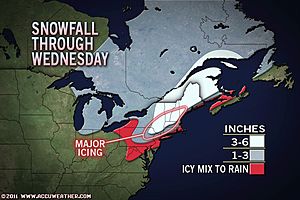
Major Ice Storm Impacting Travel Across Northeast
A disruptive winter storm will deliver a mixed bag of snow, ice and rain to the Northeast today, with some locations experiencing dangerous icing.
While the big cities from Philadelphia to Washington, D.C., have switched over to rain after some snow and ice overnight, frozen precipitation continues farther north and will expand across New England by midday.
Areas from northeastern Pennsylvania across eastern New York and interior New England stand to get several hours of freezing rain today after several inches of snow. Ice accretions of a quarter-inch or more, on top of 3 to 6 inches of snow, will severely disrupt travel and could even bring down trees and power lines.
Locations that stand to have major ice buildup today include Allentown and Scranton, Pa.; White Plains and Albany, N.Y.; Torrington, Conn.; Springfield, Mass.; Concord and Nashua, N.H. There will likely be a period of time today where travel will be downright dangerous in these areas.
Commuters will fare better around New York City, but will still deal with slick spots as snow and ice changes to plain rain by midmorning. Likewise, Providence and Boston will have a changeover to rain by afternoon.
Highways that will be more severely impacted by snow and ice include interstates 78, 80, 81, 84, 87, 90, 91, 93 and the Northeast extension of the Pennsylvania turnpike, I-476.
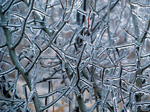
Freezing rain is perhaps the most dangerous type of winter precipitation, characterized by rainfall freezing upon contact with exposed surfaces.
In addition, the weight of the ice could cause trees and power lines to come down, knocking out power. Residents should plan ahead in the event that power could be out for several hours.
Expert Senior Meteorologist Alex Sosnowski also points out that the snow, ice and rain could be enough to lead to roof failures across New England.
[ Bericht 1% gewijzigd door #ANONIEM op 18-01-2011 13:34:42 ]
-------------------------------------------------------
Major Ice Storm Impacting Travel Across Northeast
A disruptive winter storm will deliver a mixed bag of snow, ice and rain to the Northeast today, with some locations experiencing dangerous icing.
While the big cities from Philadelphia to Washington, D.C., have switched over to rain after some snow and ice overnight, frozen precipitation continues farther north and will expand across New England by midday.
Areas from northeastern Pennsylvania across eastern New York and interior New England stand to get several hours of freezing rain today after several inches of snow. Ice accretions of a quarter-inch or more, on top of 3 to 6 inches of snow, will severely disrupt travel and could even bring down trees and power lines.
Locations that stand to have major ice buildup today include Allentown and Scranton, Pa.; White Plains and Albany, N.Y.; Torrington, Conn.; Springfield, Mass.; Concord and Nashua, N.H. There will likely be a period of time today where travel will be downright dangerous in these areas.
Commuters will fare better around New York City, but will still deal with slick spots as snow and ice changes to plain rain by midmorning. Likewise, Providence and Boston will have a changeover to rain by afternoon.
Highways that will be more severely impacted by snow and ice include interstates 78, 80, 81, 84, 87, 90, 91, 93 and the Northeast extension of the Pennsylvania turnpike, I-476.
Freezing rain is perhaps the most dangerous type of winter precipitation, characterized by rainfall freezing upon contact with exposed surfaces.
In addition, the weight of the ice could cause trees and power lines to come down, knocking out power. Residents should plan ahead in the event that power could be out for several hours.
Expert Senior Meteorologist Alex Sosnowski also points out that the snow, ice and rain could be enough to lead to roof failures across New England.
[ Bericht 1% gewijzigd door #ANONIEM op 18-01-2011 13:34:42 ]
Jan Visserquote:Er komt voorlopig geen einde aan de pittige winter in grote delen van de Verenigde Staten. Van Minneapolis naar Chicago, St. Louis en Indianapolis en verder naar het zuiden en oosten toe wordt dit de koudste week van de winter 2010-2011. Boven het noordwesten van Canada zijn zeer koude arctische luchtmassa's zich namelijk aan het hergroeperen voor een massale uitval naar het zuidoosten. In Minneapolis komen de maxima later deze week niet boven -18º Celsius. Maandag was Saranac Lake in New York met -33,9º de koudste plaats. Tijdens het afgelopen weekeinde registreerde Babbitt, Minnesota zowel zaterdag als zondag -37,2º.

Amerikaanse Midwest breekt alle kouderecords: -40 graden
De Amerikaanse Midwest is gisteren ten prooi gevallen aan ijskoude temperaturen. Op sommige plaatsen daalde het kwik tot lager dan -40 graden Celsius, zo blijkt uit gegevens van de Amerikaanse meteorologische dienst National Weather Service (NWS).
In Minnesota werd een kouderecord gebroken. In de stad International Falls, dichtbij de Canadese grens, werd een temperatuur van -43 graden opgemeten. Het gaat om het record sinds 1897 en het begin van de metingen. Vandaag waren de temperaturen alweer wat gestegen (-25°), maar voelde het kouder aan als gevolg van de wind. Het NWS stuurde een waarschuwing de wereld in voor de risico's op bevriezing en dodelijk gevaarlijke onderkoeling.
Uitzonderlijk
Januari is doorgaans een bijzonder koude maand in de Midwest, waaronder acht staten vallen (Illinois, Indiana, Iowa, Michigan, Minnesota, Missouri, Ohio en Wisconsin), maar volgens meteorologen zijn de temperaturen van het voorbije weekend uitzonderlijk. (belga/ep)
bron
toch heeft het uiterste westen van Canada (Vancouver) alweer een hele zachte winter net als vorig jaar, Minnesota, Illenois e.d. staan bekend om hun koude winters
Komt weer dertig centimter op NewYork e.o. afquote:Snow emergency declared
Winter-weary New Yorkers headed to work Wednesday in yet another snowstorm, with frosty forecasts warning of up one new foot of the white stuff.
The first flakes started gently falling around 8 a.m., with the National Weather Service issuing a winter storm warning in effect from 10 a.m. Wednesday until 6 a.m. Thursday.
And Mayor Bloomberg issued a weather emergency declaration, part of the city's new snow response in the wake of the widely criticized mishandling of the Dec. 26 blizzard.
The move urges drivers to stay off the roads; suspends alternate side of the street parking, parking meter payments and garbage collection; and allows the city to tow cars blocking snow plows at the owner's expense.
The storm should dump between between 7 and 13 inches of snow on a city already battered by the post-Christmas blizzard and several smaller blasts.
By Wednesday afternoon, a mix of snow and sleet was expected to make a mess of the evening commute. The heaviest snow was expected at night, with wind gusts of 31 mph adding to the weather woes.
The snowfall was already causing arrival delays of about an hour at LaGuardia Airport, while Newark and JFK airports reported snow-related delays in arrivals and departures.
In a strange twist, the bad weather also forced cancellation of the City Council's public hearing on the South Brooklyn blizzard response.
quote:Winterweer bemoeilijkt dagelijks leven noordoosten VS
AMSTERDAM – Grote hoeveelheden sneeuw en een ijzige storm leggen het dagelijks leven in het noordoosten van de Verenigde Staten steeds verder stil. In New York blijven de scholen donderdag voor de tweede dag gesloten, meldt BNO News.
De drie grootste luchthavens van New York hebben samen al meer dan duizend vluchten geannuleerd. En Philadelphia International Airport laat donderdag aan persbureau AP weten te verwachten zeker duizend reizigers te moeten duperen als gevolg van geannuleerde vluchten.
AP weet bovendien te melden dat in het rond de hoofdstad Washington zo’n 300.000
huishoudens hinder ondervinden van stroomuitval en gevaarlijke situaties op de weg.
In en rond New York City ligt een pak sneeuw van enkele tientallen centimeters. Volgens meteorologen kan er nog zo'n 35 centimeter vallen.
Snelwegen
Woensdag werden sommige snelwegen werden al afgesloten omdat ze nauwelijks nog begaanbaar waren. Bomen konden het pak sneeuw niet meer dragen en vielen om.
In Washington verwacht met nog zo'n 25 centimeter sneeuw en in Philadelphia en Boston 28 centimeter. De storm trekt uiterst langzaam verder en zal nog enkel dagen aanhouden.
Sneeuwstorm hindert Obama: luchtverkeer in VS weer plat

De oostkust van de Verenigde Staten krijgt een wel zeer strenge winter te verduren. Een sneeuwstorm die tot 30 cm sneeuw produceerde, legde nog maar eens het luchtverkeer rond New York en Washington plat. Zelfs de president werd niet gespaard. Marine One, Obama's presidentiële helikopter kon niet opstijgen en Barack Obama moest in escorte de sneeuwfiles trotseren om na een trip naar Wisconsin naar aanleiding van zijn State of The Union weer in het Witte Huis te geraken. Duizenden passagiers en toeristen strandden op de gesloten luchthavens en honderdduizenden Amerikanen kwamen urenlang zonder stroom te zitten. Gelukkig is het weer ondertussen verbeterd.
Vooral de omgeving van New York en Washington werd ongemeen hard getroffen. Over 'The Big Apple' woedde zelfs een heus 'sneeuwonweer'. Toen de felle regen overging in sneeuw, begeleidden bliksemschichten de witte vlokken. De drie grootste luchthavens van New York gingen urenlang dicht. Omdat het om de drukste luchthavens van het hele land gaat, moesten duizenden vluchten geschrapt worden. Duizenden passagiers waren gestrand op de luchthavens.
Aanschuiven in sneeuwfiles
Ook Barack Obama werd niet gespaard van winterellende. Air Force One, het presidentiële vliegtuig, kon de president nog wel veilig afzetten op een militaire basis in de buurt van Washington. Normaal gesproken moest Marine One, de bekende presidentiële heli, Obama dan naar het Witte Huis vliegen, maar dat was onmogelijk in de sneeuwstorm. Aanschuiven dan maar in de sneeuwfiles. Obama's konvooi deed er liefst drie keer langer over dan dan normaal en de president geraakte pas na meer dan een uur aanschuiven op zijn kantoor. (kh)


hln
Er komt weer wat aan: Multi-Day Dangerous, Destructive Winter Storm
De verwachtingen voor West Michigan zijn 10 inches sneeuw op dinsdag.
-1F in Texas.
[ Bericht 30% gewijzigd door popolon op 31-01-2011 13:24:19 ]
De verwachtingen voor West Michigan zijn 10 inches sneeuw op dinsdag.

-1F in Texas.
[ Bericht 30% gewijzigd door popolon op 31-01-2011 13:24:19 ]
Patience is not one of my virtues, neither is memory. Or patience for that matter.

Gaat goed, potentieel historische storm in de VS, historische cycloon koerst af op Australie, waar blijft die historische februari storm voor Nederlandquote:A huge and potentially historic winter storm is taking shape over the Southern Plains today. By the time the storm exits New England on Wednesday night, as many as 100 million Americans may see heavy snows of at least 6 inches or dangerous ice accumulations of 1/4" or more from the massive storm. A potent jet stream with strong winds will dive southwards over the central U.S. today, allowing a cold Arctic airmass to spill southwards out of Canada. In front of this cold air, a flow of very warm, moist air from the Gulf of Mexico will surge northwards, providing copious moisture to fuel snowfall amounts that will likely approach two feet across portions of Iowa and Illinois on Tuesday. The storm could be Chicago's biggest blizzard since January 1999, when a storm dumped 21.6" of snow. Accompanying the heavy snow on Tuesday will be strong winds gusting to 40 mph in Northern Illinois and Northwest Indiana, and a blizzard watch is posted for Chicago. Strong winds in Chicago are expected to generate 14 - 18 feet waves on Lake Michigan, with occasional waves up to 25 feet. A significant coastal flooding event is possible for Chicago, with beach erosion and flooding along Lake Shore Drive. Many major cities will likely receive over 8 inches of snow from the storm, including Kansas City, St. Louis, and Detroit. Perhaps of greater concern is the potential for a major ice storm along a swath from Northwest Oklahoma to Massachusetts. Widespread freezing rain is expected to bring over 1/4" of ice to many major cities, including St. Louis, Indianapolis, Columbus, Cleveland, and Pittsburgh. Some regions could see up to an inch of ice, and widespread power outages due to toppled power lines are likely for millions of people. Damages exceeding $1 billions are possible from this ice storm. In addition, the storm's powerful cold front will bring the potential for severe thunderstorms to the deep South. The NOAA Storm Prediction Center is giving Louisiana and surrounding states a "slight risk" of severe weather on Tuesday, and severe thunderstorms with damaging winds are likely Tuesday afternoon in this region.
Wat een temperatuur gradienten zeg. 40 graden F verschil over een afstand van een paar duizend kilometer. De uitval van koude poollucht over de vlaktes langs de oostzijde van de Rockies is mooi te zien. 
Oklahoma maakt zich op voor 8 tot 13 inch sneeuw. Tevens een gevoelstemperatuur van -20.
Edit: Vliegveld in OKC & Tulsa zijn gesloten momenteel. 8 inch aan sneeuw in OKC.
[ Bericht 19% gewijzigd door Drassss op 01-02-2011 19:36:06 ]
Edit: Vliegveld in OKC & Tulsa zijn gesloten momenteel. 8 inch aan sneeuw in OKC.
[ Bericht 19% gewijzigd door Drassss op 01-02-2011 19:36:06 ]
The Great Blizzard of February 1 - 2, 2011 is here.
Oklahoma City is experiencing whiteout conditions, with heavy snow of 2 inches per hour being driven by ferocious winds of 36 mph, gusting to 46 mph. With a temperature of just 9°F, this is an extremely dangerous storm for the city, and all of Oklahoma has been placed under a state of emergency. Seven inches of snow had fallen in Oklahoma City as of 7am EST. Dangerous blizzard conditions extend from Oklahoma, through northwest Arkansas, southeast Kansas, and southern Missouri this morning, and blizzard conditions are expected to spread northeastward into eastern Iowa, southern Wisconsin, most of Illinois, southern Michigan, northern Indians, and northwest Ohio later today. Cold air is being driven southwards out of Canada by a high pressure system over Montana that is at near-record strength. Pressures at Glasgow, Montana this morning were 1054 mb, close to the all-time U.S. high pressure record of 1064 mb set in Montana in 1983. Copious moisture is streaming northwards from the Gulf of Mexico to fuel the blizzard, and snowfall amounts will likely approach two feet across portions of Iowa and Illinois today, making it one of the top-ten snowstorms in history for the region. The storm will probably be Chicago's biggest blizzard since January 2 - 4 1999, when a storm dumped 21.6" of snow. With today's snowstorm expected to have very unstable air aloft, "thundersnow" with snowfall rates of 4 inches/hour is possible, and there is a chance today's blizzard could rival Chicago's greatest snow storm of all time, the blizzard of January 26 - 27, 1967. That immense storm dumped 23 inches of snow on Chicago, stranding thousands of people and leaving an estimated 800 Chicago Transit Authority buses and 50,000 automobiles abandoned on the city streets and expressways. Twenty six Chicagoans died in the blizzard, mostly due to heart attacks from shoveling snow. Strong winds in Chicago today are expected to generate 14 - 18 feet waves on Lake Michigan, with occasional waves up to 25 feet. A significant coastal flooding event is possible for the city, with beach erosion and flooding along Lake Shore Drive.
Many major cities will likely receive over 12 inches of snow from the Great Blizzard of February 2011, including Kansas City, St. Louis, Detroit, and Boston. Perhaps of greater concern is the potential for a major ice storm along a swath from Northwest Oklahoma to Massachusetts. Widespread freezing rain is expected to bring over 1/4" of ice to many major cities, including Indianapolis, Columbus, Cleveland, Pittsburgh, and New York City. Some regions could see up to an inch of ice, and widespread power outages due to toppled power lines are likely for millions of people. Damages exceeding $1 billions are possible from this ice storm. In addition, the storm's powerful cold front brought severe thunderstorms to eastern Texas this morning, and severe thunderstorms will affect Louisiana, Mississippi, and Alabama today as the cold front moves east. NOAA's Storm Prediction Center has placed the region under its "slight risk" threat area for severe weather today, and a few isolated tornadoes may develop this afternoon in some of the heaviest thunderstorms.
Wunderground
TWC: National Weather Service issues first ever 'hard freeze' warning for Dallas http://bit.ly/gRNzku
Chicago meldt '17,1 inch of snow and counting' 

quote:Sneeuwstorm raast over de VS
Novum/AP) - Een zware sneeuwstorm raast momenteel over het midden van de Verenigde Staten. Luchthavens, scholen en overheidsgebouwen zijn in veel plaatsen dicht en ook delen van snelwegen in de regio zijn gesloten vanwege wat de ergste sneeuwstorm in decennia lijkt te zijn.
Sneeuwstorm raast over VS
IJzel, sneeuw en hagel teisteren Dallas, Oklahoma en Tulsa. In Chicago wordt zeker zestig centimeter sneeuw verwacht, in Indianapolis 2,5 centimeter ijs en ook in het noordoosten wordt woensdag veel ijs en sneeuw verwacht. De staat Missouri moest voor het eerst in de geschiedenis de snelweg tussen St. Louis en Kansas City vanwege sneeuw sluiten. In Texas werden windsnelheden van honderd kilometer per uur gemeten en zaten duizenden mensen dinsdag uren zonder stroom.
Meteoroloog Jeff Johnson zei dat de storm ongetwijfeld 'het verkeer nog enkele dagen zal verlammen'. Hij waarschuwde dat sneeuw en wind bovendien een gevaarlijk combinatie zijn, ook in gebieden waar niet veel sneeuw is voorspeld. Veel mensen nemen het advies thuis te blijven dan ook ter harte. "Je wil niet in een landelijk gebied vastzitten in je auto met dit weer", zei Johnson. In Oklahoma is de Nationale Garde ingezet om gestrande automobilisten te helpen.
De storm heeft zich woensdag richting het noordoosten verplaatst, waar steden sinds december al verschillende malen door sneeuwstormen zijn getroffen.


Snelwegen in Oklahoma zijn goed te doen, maar als je een afslag moet hebben sta je meteen vast
Wat minder nieuws...
Wat minder nieuws...
quote:OKLAHOMA CITY The medical examiner's office has confirmed a 20-year-old was killed in a sledding accident Tuesday evening.
The fatal accident happened in the 8000 block of Stanley Draper Drive. The woman died after the sled she was riding on hit a guardrail.
Investigators say the victim was being pulled on the sled by a pickup truck. At least three people were in the truck when the accident happened.
A spokeswoman for Oklahoma City police said it was too soon to say in the accident would be turned over to the District Attorney's Office for further review.
Officieel een 'snow day', thuisblijven vandaag dus.  Zo'n beetje alles ligt plat in West Michigan.
Open je je deur:
Open je je deur:

Patience is not one of my virtues, neither is memory. Or patience for that matter.
snow Spirals:
As a winter storm of historic proportions sweeps across the central USA this week, midwesterners should be alert for some unaccustomed sights. One of them is snow spirals. Michael French photographed this specimen in Frederick, Maryland, on Jan. 29th:
"I call them Karra Spirals, after my wife Karra Strickland who discovered them in our yard," says French. "They were all over town, spiraling down the braided metal guy-wires on telephone poles. Here's the curious thing: The wires were spun clockwise, while the snow formations were spun anti-clockwise. The hardened snow spirals were rotated opposite of the metal wire's weave. We also noticed that spirals near the top of the wires were longer (~1 meter) than spirals at the bottom (0.1 - 0.3 meters)--perhaps because of gravity?"
Indeed, the changing wavelength of the spiral suggests gravity played a role in their formation. This could be how heavy snow sags under its own weight when it clings to a braided wire. Why the spirals should oppose the braid, however, is not obvious.
www.spaceweather.com
As a winter storm of historic proportions sweeps across the central USA this week, midwesterners should be alert for some unaccustomed sights. One of them is snow spirals. Michael French photographed this specimen in Frederick, Maryland, on Jan. 29th:

"I call them Karra Spirals, after my wife Karra Strickland who discovered them in our yard," says French. "They were all over town, spiraling down the braided metal guy-wires on telephone poles. Here's the curious thing: The wires were spun clockwise, while the snow formations were spun anti-clockwise. The hardened snow spirals were rotated opposite of the metal wire's weave. We also noticed that spirals near the top of the wires were longer (~1 meter) than spirals at the bottom (0.1 - 0.3 meters)--perhaps because of gravity?"
Indeed, the changing wavelength of the spiral suggests gravity played a role in their formation. This could be how heavy snow sags under its own weight when it clings to a braided wire. Why the spirals should oppose the braid, however, is not obvious.
www.spaceweather.com
<a href="http://www.vwkweb.nl/" rel="nofollow" target="_blank">[b]Vereniging voor weerkunde en klimatologie[/b]</a>
<a href="http://www.estofex.org/" rel="nofollow" target="_blank">[b]ESTOFEX[/b]</a>
<a href="http://www.estofex.org/" rel="nofollow" target="_blank">[b]ESTOFEX[/b]</a>