WKN Weer, Klimaat en Natuurrampen
Lees alles over het onstuimige weer op onze planeet, volg orkanen en tornado's, zie hoe vulkanen uitbarsten en hoe Moeder Aarde beeft bij een aardbeving. Alles over de verwoestende kracht van onze planeet en tal van andere natuurverschijnselen.


Heb je ook plaatsnamen waar die eventueel aan land zou kunnen gaan?
Doe mee met het voorspellen van het weer!
Weekvoorspelling | Week 1 (invullen tot 29-12 - 11:59)
Maandvoorspelling Januari
Jaarvoorspelling 2025 / 2026
Weekvoorspelling | Week 1 (invullen tot 29-12 - 11:59)
Maandvoorspelling Januari
Jaarvoorspelling 2025 / 2026
quote:Op vrijdag 17 september 2010 13:23 schreef SpeedyGJ het volgende:
Heb je ook plaatsnamen waar die eventueel aan land zou kunnen gaan?

Taiwan ligt ook lekker orkaangevoelig zeg. Het Caribische eiland van de Pacific 
Bijzonder eigenlijk dat er veel minder aandacht gegeven wordt aan Pacific Hurricanes.
Bijzonder eigenlijk dat er veel minder aandacht gegeven wordt aan Pacific Hurricanes.
Voor als nog gewoon 18m/s op de planning, zal uiteraard nog wel opgevoerd worden.

Doe mee met het voorspellen van het weer!
Weekvoorspelling | Week 1 (invullen tot 29-12 - 11:59)
Maandvoorspelling Januari
Jaarvoorspelling 2025 / 2026
Weekvoorspelling | Week 1 (invullen tot 29-12 - 11:59)
Maandvoorspelling Januari
Jaarvoorspelling 2025 / 2026
Op welke site kun je dit soort beelden vinden?quote:
http://www.opnaardehorizon.blogspot.com, mijn reisblog over 6 maanden Zuidoost-Azië
Deze had ik van een nieuwsite (HLN)quote:Op vrijdag 17 september 2010 14:05 schreef Timm-E het volgende:
[..]
Op welke site kun je dit soort beelden vinden?
maar hier kun je ook beelden vinden.
http://www.fvalk.com/day_image.htm

Check die wind eens toenemen op het laatst  116kt das gewoon 214km/h (als ik het goed heb?).
Doe mee met het voorspellen van het weer!
Weekvoorspelling | Week 1 (invullen tot 29-12 - 11:59)
Maandvoorspelling Januari
Jaarvoorspelling 2025 / 2026
Weekvoorspelling | Week 1 (invullen tot 29-12 - 11:59)
Maandvoorspelling Januari
Jaarvoorspelling 2025 / 2026
Het seizoen is nog niet voorbij.
quote:Hurricanes to Threaten US Late in September, October
While no hurricanes have thus far made landfall on the U.S., forecast weather patterns during the last part of September into October and the first part of November suggest that may be about to change.
AccuWeather.com Hurricane Expert Joe Bastardi is holding firm with his prediction of 18 to 21 named storms in the Atlantic 2010 hurricane season.
Additionally, Joe still expects multiple direct impacts on the U.S.
As the Cape Verde season winds down in October, which is a typical occurrence, the raging La Nina in the Pacific opens the door for warm waters in the Caribbean and the Gulf of Mexico to take center stage.
Changing weather patterns and the approach of cool fronts from northern latitudes would then generate and help steer these tropical storms and hurricanes onto the U.S. coastline in the Gulf, and potentially along the Atlantic Seaboard.
Joe stated that the Cape Verde season typically winds down in October, as prior hurricanes have churned and cooled these waters. At the same time, the Asian Monsoon diminishes, ending the parade of disturbances across Africa and the infamous tropical waves around the Cape Verde Islands.
Breeding grounds during the last third of hurricane season typically migrate toward the Caribbean, Gulf of Mexico, and far western Atlantic because of this.
According to Bastardi, "A switch from an El Nino to La Nina pattern is notorious for a jam-packed late hurricane season."
As a result, people in the coastal U.S., especially along the Gulf of Mexico, should not let their guard down.
Joe asserts, "There is an imbalance in the atmosphere, and much more energy has yet to be released."
Incidentally, at least one computer model insists a potent hurricane will form in the western Caribbean or the southern Gulf of Mexico before the end of September.


Even in het Nederlandsquote:
Orkanen kunnen ook in september en oktober de VS teisteren
Terwijl er momenteel nog geen zware orkanen aan land zijn gekomen in de VS, zal dit volgens de voorspellingen in het laatste deel van september en begin oktober gaan veranderen. AccuWeather.com orkaan expert Joe Bastardi houdt stevig vast aan zijn voorspelling, dat in dit seizoen in de Atlantische oceaan 18 tot 21 orkanen cq tropische systemen met een naam, zullen voorkomen. Bovendien voorspelt Joe meerdere impacts van orkanen op het vasteland van VS.
Als het storm seizoen vanuit Kaapverdië in oktober ten einde komt, wat een normale gebeurtenis is, zet de razende La Nina in de Pacific de deur open voor het warme water vanuit de Caribische zee en vanuit de Golf van Mexico. De veranderende weerpatronen en de aanstormde koufronten vanuit het noorden zullen de tropische stormen en orkanen helpen ontstaan en zelfs nog verder opporren. De tropische systemen zullen naar de kustlijn in de Golf van Mexico en vermoedelijk langs de hele Atlantische kustlijn geduwd worden. Joe verklaart, dat de typische winden rond het Kaapverdische eilanden normaal in oktober luwen doordat eerdere orkanen de wateren rond de eilanden hebben rondgedraaid en afgekoeld. Tegelijkertijd vermindert de Aziatische moesson, waarmee een einde komt aan verstoringen boven Afrika en gaan de beroemde hoge golven rond de Kaapverdische eilanden liggen. De broedplaats voor de orkanen verplaatst hierdoor in het laatste derde gedeelte van het orkaanseizoen naar de Caribische zee, de golf van Mexico en het westelijke gedeelte van de Atlantische oceaan.
Volgens Bastardi is de verandering van El Nino naar La Nina berucht voor een druk cq verlaat orkaanseizoen. Als gevolg hiervan moeten de mensen aan de kust van de VS en vooral in de Golf van Mexico op hun hoede blijven. Er is, volgens Joe, een instabiliteit in de atmosfeer en veel energie hiervan moet nog vrijkomen. Tenslotte geeft het hieronder getoonde computermodel aan, dat een potentiële orkaan zich nog voor het einde van september zal vormen in de westelijke Caribische zee of in het zuidelijke gedeelte van de Golf van Mexico.
Bron onweer-online.nl
Weer of geen weer, altijd actueel www.onweer-online.nl
Er is alweer een 10% area bij. Ligt zuidelijker dan de vorige orkanen, dus ik geef deze wel een kans van slagen wat betreft de Golf van Mexico. Maar dat duurt nog wel 2 weken.
's Avonds een man, overdags rustig an

Doden in Mexico door orkaan Karl
Orkaan Karl is boven het zuiden van Mexico zo sterk afgezwakt, dat het een tropische storm is geworden. Hevige regen veroorzaakt wel overstromingen en aardverschuivingen in het gebied.
In de staat Puebla, ten oosten van Mexico-Stad, vielen twee doden, toen een huis werd bedolven onder een modderstroom.
Karl ontstond ongeveer een week geleden in de buurt van Venezuela. Woensdag trok de tropische storm over het Mexicaanse schiereiland Yucatan. Daarna zwol Karl boven het warme water van de Golf van Mexico aan tot orkaankracht.
Bron
Ik ben illegaal!
Op woensdag 1 december 2010 16:07 schreef honkeytonk het volgende:Ik denk zelfs dat ze achter de schermen een fantopic over mij hebben geopend :Y
Op woensdag 1 december 2010 16:07 schreef honkeytonk het volgende:Ik denk zelfs dat ze achter de schermen een fantopic over mij hebben geopend :Y
Taiwan krijgt ook een voltreffer. Typhoon FANAPI is nu een cat 3.
Windsnelheid van 193 km.uur met windstoten tot 221 km.uur.
Windsnelheid van 193 km.uur met windstoten tot 221 km.uur.
Bermuda:
Ik heb zulke vaantjes nog nooit gezien.
Tussen 22 - 00 staat 33m/s. Tussen 00 - 02 weet ik nog niet, maar dat zal rond de 36m/s zijn.

Ik heb zulke vaantjes nog nooit gezien.
Tussen 22 - 00 staat 33m/s. Tussen 00 - 02 weet ik nog niet, maar dat zal rond de 36m/s zijn.
Doe mee met het voorspellen van het weer!
Weekvoorspelling | Week 1 (invullen tot 29-12 - 11:59)
Maandvoorspelling Januari
Jaarvoorspelling 2025 / 2026
Weekvoorspelling | Week 1 (invullen tot 29-12 - 11:59)
Maandvoorspelling Januari
Jaarvoorspelling 2025 / 2026
Het gebied voor de kust van Afrika is nu 60%, dus dat zal vast wel een nieuwe orkaan worden. Ben benieuwd of die nou eens een zuidelijkere koers zal gaan aanhouden. Achter het 60%-gebied ligt nog een groot complex klaar, dus het wordt weer druk de komende 2 weken.
En Igor stelt trouwens ook niet veel meer voor afgezien van de regenval.
En Igor stelt trouwens ook niet veel meer voor afgezien van de regenval.
's Avonds een man, overdags rustig an
Zeer zware storm tot orkaan kracht. Live stream
Ergens bij de baai
edit:
[ Bericht 15% gewijzigd door SpeedyGJ op 20-09-2010 00:01:11 ]
Ergens bij de baai
edit:
quote:Bermuda, eastern side of the island. this cam is towards west end
[ Bericht 15% gewijzigd door SpeedyGJ op 20-09-2010 00:01:11 ]
Doe mee met het voorspellen van het weer!
Weekvoorspelling | Week 1 (invullen tot 29-12 - 11:59)
Maandvoorspelling Januari
Jaarvoorspelling 2025 / 2026
Weekvoorspelling | Week 1 (invullen tot 29-12 - 11:59)
Maandvoorspelling Januari
Jaarvoorspelling 2025 / 2026
Normaal gezien maken al die KaapVerde orkanen een nette draai naar het noorden; zuidelijker dan de route St. Maarten - Haiti - Cuba - Texas doen ze niet heel vaak. Veel van de orkanen die Yucatan etc. bedreigen ontstaan in de caraiben.quote:Op zondag 19 september 2010 12:19 schreef Burnie88 het volgende:
Het gebied voor de kust van Afrika is nu 60%, dus dat zal vast wel een nieuwe orkaan worden. Ben benieuwd of die nou eens een zuidelijkere koers zal gaan aanhouden. Achter het 60%-gebied ligt nog een groot complex klaar, dus het wordt weer druk de komende 2 weken.
En Igor stelt trouwens ook niet veel meer voor afgezien van de regenval.
Zou best kunnen!quote:
[ afbeelding ]
Komt dit voort uit de resten van Orkaan Karl?
Dat betekent dus dat die misschien voor de 3de keer gaat activeren? Zal waarschijnlijk wel geen orkaan meer worden maar toch
Doe mee met het voorspellen van het weer!
Weekvoorspelling | Week 1 (invullen tot 29-12 - 11:59)
Maandvoorspelling Januari
Jaarvoorspelling 2025 / 2026
Weekvoorspelling | Week 1 (invullen tot 29-12 - 11:59)
Maandvoorspelling Januari
Jaarvoorspelling 2025 / 2026
Er lijkt deze week ook nog een storm te ontstaan in de Caribische zee. De Golf lijkt voorlopig rustig.


Ik lees net op Accuweather dat dat inderdaad gaat gebeuren. En die orkaan zal de V.S. ook gaan bereiken. Begin oktober staat dat gepland.quote:Op maandag 20 september 2010 15:35 schreef aloa het volgende:
Er lijkt deze week ook nog een storm te ontstaan in de Caribische zee. De Golf lijkt voorlopig rustig.
's Avonds een man, overdags rustig an
Deze week lijkt er ook al een te ontstaan, die trekt dan over Nicaraqua en Honduras.quote:Op maandag 20 september 2010 19:06 schreef Burnie88 het volgende:
[..]
Ik lees net op Accuweather dat dat inderdaad gaat gebeuren. En die orkaan zal de V.S. ook gaan bereiken. Begin oktober staat dat gepland.
Afwachten maar.
10% voor het gebied bij de Windward Islandsquote:Op maandag 20 september 2010 19:11 schreef aloa het volgende:
[..]
Deze week lijkt er ook al een te ontstaan, die trekt dan over Nicaraqua en Honduras.
Afwachten maar.
Die zou wel eens het zelfde kunnen gaan doen als Karl.quote:Op dinsdag 21 september 2010 11:44 schreef Frutsel het volgende:
[..]
10% voor het gebied bij de Windward Islands
Weer of geen weer, altijd actueel www.onweer-online.nl

Ben benieuwd naar dat gebied in de Carraïben.. Lisa gaat niets worden, die wordt tegengehouden door hogedrukgebieden lijkt het wel.
's Avonds een man, overdags rustig an
Tropische Storm Lisa ontstaan
Orkaan Igor is de afgelopen uren duidelijk zwakker geworden en nog net een klasse-1-orkaan met windsnelheden tot 120 km/u. De storm zal de komende uren zijn tropische eigenschappen verliezen en tot een gewone stormdepressie transformeren, die rakelings langs de Canadese oostkust trekt. Canada heeft voorzorgsmaatregelen getroffen en waarschuwingen uitstaan, maar veel schade wordt er niet verwacht, omdat de storm snel aan het afzwakken is.
Tropische storm Lisa ontstaan
Ondertussen is de volgende tropische storm alweer ontstaan die van het National Hurricane Center (NHC) de naam "Lisa" gekregen heeft. Lisa is de twaalfde tropische storm op de Atlantische Oceaan dit jaar. De storm zal zich de komende dagen over warm water en met weinig schadelijke windschering verder kunnen versterken en mogelijk binnen enkele dagen orkaanstatus bereiken. De baan van de storm is momenteel noordelijk en de verdere trekrichting nog erg onzeker omdat Lisa in een windzwakke omgeving ontstaan is, maar veel modellen berekenen dat het systeem over enkele dagen met de passaatwinden naar het westen zal trekken, zoals de meeste tropische stormen die in dit gebied ontstaan.
Het orkanenseizoen 2010 is inmiddels goed bezig om de meeste tropische stormen sinds het recordseizoen 2005 te produceren. Met Lisa zijn er tot nu toe 12 tropische stormen ontstaan en het seizoen zal nog tot 30 november duren. Het NHC had al begin dit jaar voor een buitengewoon actief orkanenseizoen gewaarschuwd, volgens hun zouden 15-18 tropische stormen kunnen ontstaan waarvan er vier tot een major hurricane (klasse 3 of hoger met windsnelheden van minimaal 111 mph of 180 km/u) zouden uit kunnen groeien. Met Danielle, Earl, Igor, Julia en Karl zijn er inmiddels al 5 orkanen die daadwerkelijk "major hurricane"-status bereikt hebben en het is goed mogelijk dat er nog eentje zal ontstaan die tot een major hurricane uit kan gaan groeien.
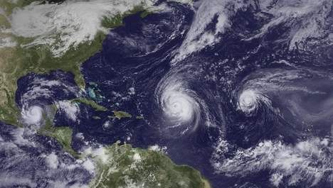
Orkaan Igor was tot nu toe het sterkste systeem van het orkanenseizoen met windsnelheden tot 250 km per uur en een luchtdruk van 929 hpa. Bovendien had de storm een prachtige, bijna perfecte wolkenstructuur en was dus erg fotogeniek.
Het valt op dat de meeste stormen tot nu toe in het gebied van de Kaapverdische Eilanden zijn ontstaan en ruim buiten het bereik van land gebleven zijn. Uitzonderingen zijn de Orkanen Alex en Karl, die in de Caribische Zee zijn ontstaan en de oostkust van Mexico bereikten, en de tropische stormen Bonnie en Hermine. De Amerikanen hebben tot nu toe veel geluk gehad, alleen major hurricane Earl schampte de oostkust maar bleef met zijn centrum over water, de schade viel uiteindelijk erg mee. Dit is een duidelijk afwijking van de verwachtingen van het NHC, die eerder dit jaar een hoge "landfall"-kans van 70% voorspeld hadden.
Bron Weerdirect
Orkaan Igor is de afgelopen uren duidelijk zwakker geworden en nog net een klasse-1-orkaan met windsnelheden tot 120 km/u. De storm zal de komende uren zijn tropische eigenschappen verliezen en tot een gewone stormdepressie transformeren, die rakelings langs de Canadese oostkust trekt. Canada heeft voorzorgsmaatregelen getroffen en waarschuwingen uitstaan, maar veel schade wordt er niet verwacht, omdat de storm snel aan het afzwakken is.

Tropische storm Lisa ontstaan
Ondertussen is de volgende tropische storm alweer ontstaan die van het National Hurricane Center (NHC) de naam "Lisa" gekregen heeft. Lisa is de twaalfde tropische storm op de Atlantische Oceaan dit jaar. De storm zal zich de komende dagen over warm water en met weinig schadelijke windschering verder kunnen versterken en mogelijk binnen enkele dagen orkaanstatus bereiken. De baan van de storm is momenteel noordelijk en de verdere trekrichting nog erg onzeker omdat Lisa in een windzwakke omgeving ontstaan is, maar veel modellen berekenen dat het systeem over enkele dagen met de passaatwinden naar het westen zal trekken, zoals de meeste tropische stormen die in dit gebied ontstaan.

Het orkanenseizoen 2010 is inmiddels goed bezig om de meeste tropische stormen sinds het recordseizoen 2005 te produceren. Met Lisa zijn er tot nu toe 12 tropische stormen ontstaan en het seizoen zal nog tot 30 november duren. Het NHC had al begin dit jaar voor een buitengewoon actief orkanenseizoen gewaarschuwd, volgens hun zouden 15-18 tropische stormen kunnen ontstaan waarvan er vier tot een major hurricane (klasse 3 of hoger met windsnelheden van minimaal 111 mph of 180 km/u) zouden uit kunnen groeien. Met Danielle, Earl, Igor, Julia en Karl zijn er inmiddels al 5 orkanen die daadwerkelijk "major hurricane"-status bereikt hebben en het is goed mogelijk dat er nog eentje zal ontstaan die tot een major hurricane uit kan gaan groeien.

Orkaan Igor was tot nu toe het sterkste systeem van het orkanenseizoen met windsnelheden tot 250 km per uur en een luchtdruk van 929 hpa. Bovendien had de storm een prachtige, bijna perfecte wolkenstructuur en was dus erg fotogeniek.
Het valt op dat de meeste stormen tot nu toe in het gebied van de Kaapverdische Eilanden zijn ontstaan en ruim buiten het bereik van land gebleven zijn. Uitzonderingen zijn de Orkanen Alex en Karl, die in de Caribische Zee zijn ontstaan en de oostkust van Mexico bereikten, en de tropische stormen Bonnie en Hermine. De Amerikanen hebben tot nu toe veel geluk gehad, alleen major hurricane Earl schampte de oostkust maar bleef met zijn centrum over water, de schade viel uiteindelijk erg mee. Dit is een duidelijk afwijking van de verwachtingen van het NHC, die eerder dit jaar een hoge "landfall"-kans van 70% voorspeld hadden.

Bron Weerdirect
Weer of geen weer, altijd actueel www.onweer-online.nl
Ik ben ook benieuwd naar dat gebied. Kans is aanwezig dat deze Nicaraqua en Honduras overtrekt om vervolgens in de Caribische zee weer aan kracht te winnen.quote:Op dinsdag 21 september 2010 13:39 schreef Burnie88 het volgende:
Ben benieuwd naar dat gebied in de Carraïben.. Lisa gaat niets worden, die wordt tegengehouden door hogedrukgebieden lijkt het wel.
Is nog ver weg natuurlijk. De naam na Lisa is Matthew
bronquote:Igor is trouwens nog steeds flink actief. Nog steeds razen er orkaanwinden rond het centrum en New Foundland krijgt daar een flinke veeg van mee. Zelfs als het centrum van Igor New Foundland is gepasseerd en op rond 60 graden noorderbreedte is aangekomen, wordt Igor nog op orkaansterkte gezet en pas daarna, als hij verder naar het noordwesten koerst, neemt de windsterkte af. Hoe dan ook, het moge duidelijk zijn dat Igor op zeer grote afstand van Europa blijft.
20% nuquote:
Ben benieuwd naar dat gebied in de Carraïben.. Lisa gaat niets worden, die wordt tegengehouden door hogedrukgebieden lijkt het wel.
In navolging van het reeds eerder gemeldde bericht dat de condities voor meer 'westerse' stormen gunstiger worden.

eind september en oktober dus wel degelijk kans op een "major" storm die idd wel landfall gaat maken ergens daarquote:The main concern is going to be the Caribbean Sea. I have been talking about the pattern change coming up and it is almost upon us. Most of the major computer models indicate the formation of a tropical cyclone in the western Caribbean over the course of the next week or less. Right now, the NHC has an area outlined just entering the eastern Caribbean. It should migrate westward and be situated in the western to northwestern Caribbean by the end of the week. At that point, development is likely to begin ramping up as conditions appear quite favorable going out in time. In fact, water temps in the western Caribbean are the warmest anywhere in the Atlantic Basin with extremely high ocean heat content. I need not remind you of the intense hurricanes that have come out of the northwest Caribbean over the course of history. We will need to keep a close eye on what goes on in this region from here on out as I suspect that a significant threat to land masses is in order. It is too soon to know if that threat includes Florida or elsewhere along the Gulf Coast. Right now, Jamaica, the Caymans and the Greater Antilles would be at risk from possible heavy rains and perhaps more as this system begins to organize.
En inmiddels 50% in de Carraïben. De Nederlandse Antillen worden momenteel geteisterd door hevige regenval en windstoten.
's Avonds een man, overdags rustig an
Zo te zien is landfall op Groenland toch nog mogelijk dit jaar 
Een collega van me voer in april langs de kaap verde/over de evenaar, en wist te melden dat het daar toen al over de 30C was, extreem warm. Dus gebaseerd op die waarneming verbaast het me niet heel erg.
Dat gedeelte van orkaan theorie heb ik niet goed in mijn hoofd, maar ik kan me voorstellen dat de KVstormen door hun stormtrack de Carraiben minder open stellen voor orkaanformatie, maar dat die dus nu aan de beurt zijn, aangezien de oceaan zo langzamerhand is leeggezogen.
60% inmiddels. Matthew lijkt daar te ontstaan... en dan zijn vermoedelijk Nicaragua, Honduras aan de beurt.
Afwachten wat er daarna gebeurd... kan zijn dat de storm in die gebieden uitdooft, maar iets noordelijker en hij kan zo weer opnieuw beginnen
Afwachten wat er daarna gebeurd... kan zijn dat de storm in die gebieden uitdooft, maar iets noordelijker en hij kan zo weer opnieuw beginnen
Kans is groot dat Matthew daar ontstaat en volgens GFS kan het ook een grote worden. De andere modellen laten dat ook zien. Kans is aanwezig dat deze de golf in duikt.


In Amerika hebben ze het al over Troptober.
An expected westward shift in the formation of tropical storms or hurricanes to the waters of the Caribbean and the southeastern U.S. could set the stage for tropical troubles during October. Hence, the nickname "Troptober."
The 14-day period beginning in late September into mid-October could yield three to five named systems in these waters.
The amount of disruptions to travel and oil/gas production, as well as flooding, damage and risk to human lives caused by these storms would depend on their strength and exact location.
The tropics may make up for lost time in terms of direct impacts from tropical storms and/or hurricanes on the U.S., as the nearby waters of the Gulf of Mexico, Caribbean and the southwestern Atlantic are primed to explode during October.
October may be the month the southeastern U.S. is battered by multiple tropical storms or hurricanes.
AccuWeather.com Hurricane Expert Joe Bastardi remains very concerned that the raging La Niña and its associated cool waters in the tropical Pacific have created a tremendous imbalance.
That imbalance must be dealt with via tropical cyclones in the southwest part of the Atlantic Basin where warm waters have led to a buildup of heat.
Factoring in climatology, tropical activity shifts to the far western Atlantic during October with the decline of the Cape Verde season.
Now computer models seem to be rallying to support Joe's concern with a barrage of tropical cyclones appearing to form in succession over the Caribbean and the southwestern Atlantic during the last few days of September through the first part in October.
The GFS and other models are suggesting multiple tropical cyclones will fire in the Caribbean and southwest Atlantic waters over then next few weeks. This image is the GFS forecast for Oct. 5, 2010.
If these models are right, Florida, part of the Gulf Coast, the southern Atlantic Seaboard, Cuba, Hispaniola, Puerto Rico and the Bahamas could be in for multiple rounds of heavy rains, gusty winds, rough seas and battering surf.
The combination of La Nina, climatology and the computer models should have interests keeping a very close eye on the situation in the Southwest Atlantic Basin.
Our first tropical system in this series is likely to take shape by early next week in the Caribbean.
[ Bericht 89% gewijzigd door #ANONIEM op 22-09-2010 20:17:54 ]
An expected westward shift in the formation of tropical storms or hurricanes to the waters of the Caribbean and the southeastern U.S. could set the stage for tropical troubles during October. Hence, the nickname "Troptober."
The 14-day period beginning in late September into mid-October could yield three to five named systems in these waters.
The amount of disruptions to travel and oil/gas production, as well as flooding, damage and risk to human lives caused by these storms would depend on their strength and exact location.
The tropics may make up for lost time in terms of direct impacts from tropical storms and/or hurricanes on the U.S., as the nearby waters of the Gulf of Mexico, Caribbean and the southwestern Atlantic are primed to explode during October.
October may be the month the southeastern U.S. is battered by multiple tropical storms or hurricanes.
AccuWeather.com Hurricane Expert Joe Bastardi remains very concerned that the raging La Niña and its associated cool waters in the tropical Pacific have created a tremendous imbalance.

That imbalance must be dealt with via tropical cyclones in the southwest part of the Atlantic Basin where warm waters have led to a buildup of heat.
Factoring in climatology, tropical activity shifts to the far western Atlantic during October with the decline of the Cape Verde season.
Now computer models seem to be rallying to support Joe's concern with a barrage of tropical cyclones appearing to form in succession over the Caribbean and the southwestern Atlantic during the last few days of September through the first part in October.

The GFS and other models are suggesting multiple tropical cyclones will fire in the Caribbean and southwest Atlantic waters over then next few weeks. This image is the GFS forecast for Oct. 5, 2010.
If these models are right, Florida, part of the Gulf Coast, the southern Atlantic Seaboard, Cuba, Hispaniola, Puerto Rico and the Bahamas could be in for multiple rounds of heavy rains, gusty winds, rough seas and battering surf.
The combination of La Nina, climatology and the computer models should have interests keeping a very close eye on the situation in the Southwest Atlantic Basin.
Our first tropical system in this series is likely to take shape by early next week in the Caribbean.
[ Bericht 89% gewijzigd door #ANONIEM op 22-09-2010 20:17:54 ]
Lisa is gedegradeerd to Tropische Depressie. Gebied in de Caribische zee is nog steeds 60%, maar zal nog verhoogd worden is de verwachting.
quote:An area of low pressure over the south central Caribbean may develop into Matthew over the next couple of days as conditions become more favorable for development.
Too much dry air and too much wind shear have been in place for the low to become better organized so far; however, wind shear is weakening as the low moves over very warm water of the Caribbean.
The system could organize into a depression later today and a tropical storm by Saturday.
Whether the system develops or not, it will target Central America with potentially flooding rainfall over the weekend.
The track of the system is still uncertain after it unleashes torrential rainfall over portions of Nicaragua, Honduras, Guatemala, Belize and southeastern Mexico.
Two different scenarios are that the system will keep moving westward from the Gulf of Honduras into next week or it will first stall then move northward in the Caribbean.
More models are pointing to a conclusion that the system will move northward, over Cuba. This puts Florida at risk for a direct impact from the storm by the middle of next week.
Keep checking back with AccuWeather.com for more information on the potential development of this low into Matthew.
More systems are also likely to form in the Caribbean and the southwestern Atlantic over the next couple of weeks.
