WKN Weer, Klimaat en Natuurrampen
Lees alles over het onstuimige weer op onze planeet, volg orkanen en tornado's, zie hoe vulkanen uitbarsten en hoe Moeder Aarde beeft bij een aardbeving. Alles over de verwoestende kracht van onze planeet en tal van andere natuurverschijnselen.


Inmiddels het gebied bij afrika op de kaart. 20%. De verwachting is, dat deze gaat uitgroeien tot een orkaan...

Dat systeem van 20% gaat waarschijnlijk noordwestelijk, dus hij zal wel even groeien maar daarna snel in kracht afnemen door koeler water. Helaas.
's Avonds een man, overdags rustig an
Weather Underground heeft een interessant artikel over dit orkaan seizoen en speculeert over de waarom dat dit seizoen zo uitzonderlijk rustig is. Goed leesvoer.
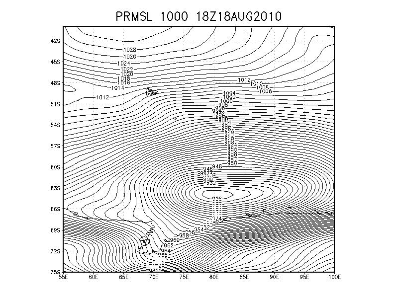
Storm van een paar dagen terug bij Antarctica met golven van 13 meter hoog en windsnelheden die gehaald worden bij een orkaan van de 2e/3e categorie.
quote:Massive 926 mb extratropical storm generating huge waves off Antarctica
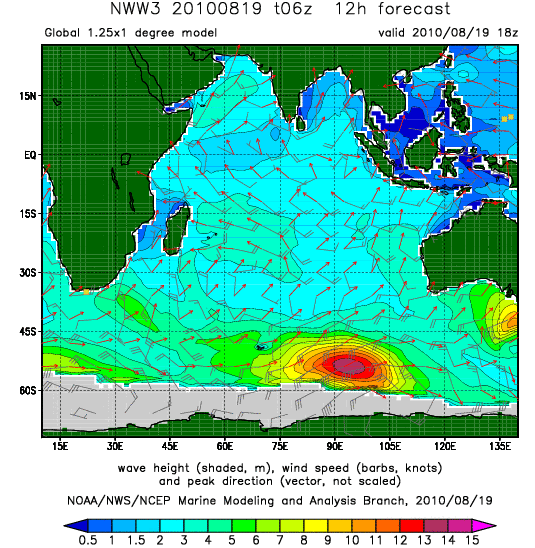
One of the most intense extratropical storms in recent years is churning up the waters near the coast of Antarctica in the South Indian Ocean. The powerful storm peaked in intensity yesterday afternoon with a central pressure of 926 mb--the type of pressure typically found in a Category 4 hurricane. Storms this intense form on average once per year, or perhaps less often, according to an email I received from Jeff Callaghan of the Australia Bureau of Meteorology. Since extratropical storms do not form eyewalls, the winds at the surface from this monster storm probably reached "only" 100 - 120 mph (equivalent to a Category 2 or 3 hurricane.) The storm is forecast to generate huge waves with asignificant wave height of 13 meters (44 feet) today, according to the NOAA Wavewatch III model (Figure 3.) I have flown into an extratropical storm this intense--in 1989, I participated in a field project based in Maine that intercepted a remarkable extratropical storm that "bombed" into a 928 mb low south of the Canadian Maritime provinces. You can read my story of that somewhat harrowing flight here.
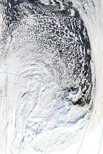
Satellite image taken at 8:10 UTC August 19, 2010, showing the intense extratropical cyclone that has weakened to 940 mb in the South Indian Ocean near the coast of Antarctica. Image credit: NASA.
Surface pressure analysis from 18 UTC August 18, 2010, showing a 926 mb low in the South Indian Ocean, just north of Antarctica. Image credit: Jeff Callaghan, Australia Bureau of Meteorology.
Predicted wave height from the NOAA Wavewatch III model for 2pm EDT (18 UTC) today, August 19, 2010. Peak wave heights of 13 meters (44 feet) are projected over ocean areas between Antarctica and Australia. Long-period waves (19 seconds between crests) up to 7 meters (22 feet) high are predicted to affect the southwest coast of Australia by Sunday. The waves are predicted to propagate eastwards to New Zealand 8 - 9 days from now, and be a respectable 4 - 5 meters high then.


Deze lijkt wel recht op Bermuda af te gaan. Nog ver weg, maar Bermuda zal er wel het nodige van meekrijgen.

En Danielle is een feit... maar zo te zien zal 'landfall' uitblijven. Denk dat Bermuda misschien wat regen krijgt, maar geen 'directhit'
in de Oost-Pacific zien we dan Frank
in de Oost-Pacific zien we dan Frank
TS Danielle
Mogelijk vanavond opgewaardeerd tot orkaan.
En dan dit:


Mogelijk vanavond opgewaardeerd tot orkaan.
En dan dit:
Zou het er toch nog van komen dan?quote:GFS says possibly 2 more storms after Danielle coming off Africa in the next 7-10 days
De volgende ligt al voor de kust van Afrika klaar.quote:Op maandag 23 augustus 2010 12:47 schreef Frutsel het volgende:
TS Danielle
[ afbeelding ]
Mogelijk vanavond opgewaardeerd tot orkaan.
En dan dit:
[..]
Zou het er toch nog van komen dan?
http://weather.myfoxtampa(...)d_sat_w_africa_1.jpg
Danielle kon wel eens uitgroeien tot de eerste "major hurricane" van 2010
Ze groeit snel... inmiddels kan ze cat.2 halen, mogelijk cat.3
Ze groeit snel... inmiddels kan ze cat.2 halen, mogelijk cat.3

quote:Tropical Storm Danielle formed as a tropical depression over the Atlantic Ocean on August 22, 2010. By the following day, Danielle had strengthened to a tropical Storm, and had the potential to become a hurricane by evening, the U.S. National Hurricane Center (NHC) reported.
The Moderate Resolution Imaging Spectroradiometer (MODIS) on NASA’s Terra satellite captured this natural-color image of Tropical Storm Danielle at 9:15 a.m. AST (13:15 UTC) on August 23. Danielle boasts the apostrophe shape typical of tropical storms, although it lacks a distinct eye.
At 11:00 a.m. AST on August 23, 2010, the NHC reported that Danielle had maximum sustained winds of 65 miles (100 kilometers) per hour, and was expected to strengthen further over the next 48 hours. Danielle 1,025 miles (1,650 kilometers) west of Cape Verde.
En die orkaan gaat zich in rap tempo opwaarderen naar categorie 3 schat ik zo... En hij gaat ook vrij recht op Bermuda af volgens de laatste voorspellingen...
's Avonds een man, overdags rustig an
Voor Bermuda buigt ie af naar het Noorden, volgens de meeste modellen.
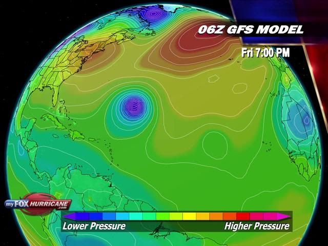
Volgens GFS gaat deze richting New Foundland en daarna richtin Europa.
Volgens GFS gaat deze richting New Foundland en daarna richtin Europa.
Toch lag, voor mijn gevoel athans, de koers al eerder noordelijker dan nu...
wat dat betreft geef ik burnie wel gelijk... het lijkt nu toch meer richting Bermuda te gaan dan voorheen,... neemt niet weg dat hij wegdraait, maar voor mijn gevoel later dan vanochtend het geval was
wat dat betreft geef ik burnie wel gelijk... het lijkt nu toch meer richting Bermuda te gaan dan voorheen,... neemt niet weg dat hij wegdraait, maar voor mijn gevoel later dan vanochtend het geval was
Hij ging eerder al recht op Bermuda af en is nu juist weer noordelijker bijgesteld. Kan wel zijn, dat de koers nu weer wat meer richting Bermuda is.
Kan nog alle kanten op. Als je de golfbewegingen ziet, dan gaat de gehele oostkust van de VS ermee te maken krijgen.
Kan nog alle kanten op. Als je de golfbewegingen ziet, dan gaat de gehele oostkust van de VS ermee te maken krijgen.
