WKN Weer, Klimaat en Natuurrampen
Lees alles over het onstuimige weer op onze planeet, volg orkanen en tornado's, zie hoe vulkanen uitbarsten en hoe Moeder Aarde beeft bij een aardbeving. Alles over de verwoestende kracht van onze planeet en tal van andere natuurverschijnselen.


Handige linkjes:
· Onweerlinks 'live'
· Stormvue-sites
· Cape en voorspellende kaarten
· Wolkenkaarten en foto's
· Diverse weersites
· Achtergrond informatie
· Golven en wind
· Buienradar Nederland
· Buienradar West Europa
Overige informatie:
· Vorige delen 'De atmosfeer staat op ontploffen'
· Openingpost 'De atmosfeer staat op ontploffen'
http://bouw.webcam.nl/hornbach/
Deze staat op de Hornbach in aanbouw in Breda. Misschien vliegen er straks nog wat bouwmaterialen rond .
.
Via 'Projecten' rechtsonder kun je er nog een aantal selecteren verspreid over heel NL.
Deze staat op de Hornbach in aanbouw in Breda. Misschien vliegen er straks nog wat bouwmaterialen rond
Via 'Projecten' rechtsonder kun je er nog een aantal selecteren verspreid over heel NL.


Nog even mijn berichtje uit het vorige topic :
Op zondag 6 juni 2010 11:35 schreef Razor21 het volgende:
LOL straks deze in de gaten houden (Haarlem) live stream staat een springkussen
http://mozart.amadeus-hotel.com:82/view/index.shtml

Op zondag 6 juni 2010 11:35 schreef Razor21 het volgende:
LOL straks deze in de gaten houden (Haarlem) live stream staat een springkussen
http://mozart.amadeus-hotel.com:82/view/index.shtml
Zo Razor21 misschien kunnen we de conducteurs afluisteren" vervolgens hoor je keihard door die trein GRRGG...Hallo hier ...blalblalb @#$%%@.....en iedereen kijkt dan onze kant op ook mijn kant..
Kan er geBBQed worden vanavond in het midden van het land zonder regen?
Winnaar FOK-Eredivisie-Toto 2025
Zou het misschien dan Nijmegen toch een beetje mijden?
----> Schumacher, je was een groot sportman! <----
En toch, het lijkt boven België wat in te zakken. Maar goed, de dag duurt nog lang.
Op donderdag 28 juni 2012 20:52 schreef Peterselieman het volgende:
We hebben Sjorsduels. Saaie wedstrijden waarin niets gebeurt en die ellendig lang duren :P
We hebben Sjorsduels. Saaie wedstrijden waarin niets gebeurt en die ellendig lang duren :P

Hm, wilde eigenlijk nog flink wat km's rijden in de Eifel maar denk dat ik maar een kortere tocht in zuid Limburg ga rijden  .
.
♫
De WebCam is weerbestendigquote:Op zondag 6 juni 2010 11:42 schreef JDude het volgende:
http://bouw.webcam.nl/hornbach/
Deze staat op de Hornbach in aanbouw in Breda. Misschien vliegen er straks nog wat bouwmaterialen rond
Via 'Projecten' rechtsonder kun je er nog een aantal selecteren verspreid over heel NL.
We zullen zien
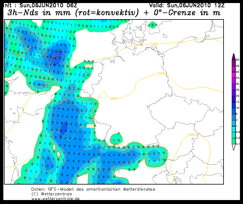
Hagel kaartje
Trouwens, wat er nu aan buien nederland binnen trekt is niet zo interessant. Wat er na 15.00 uur gebeurt, daar moeten we ons op focussen.

Trouwens, wat er nu aan buien nederland binnen trekt is niet zo interessant. Wat er na 15.00 uur gebeurt, daar moeten we ons op focussen.
* I intend to live forever, so far so good! *
Hallo 
Is hier fucking benauwd al, toch nog maar even buiten zitten nu. Wind trekt aan en dat is wel lekker
Is hier fucking benauwd al, toch nog maar even buiten zitten nu. Wind trekt aan en dat is wel lekker
Op donderdag 12 oktober 2006 09:27 schreef SCH het volgende:
flugeltje is een kloon van yvonne toch?
flugeltje is een kloon van yvonne toch?
Het begint toch wat minder te worden en de "pitjes" sterven toch wat uit in België, maar uiteraard het is pas 12u smiddags.
Waar is hier?quote:Op zondag 6 juni 2010 11:58 schreef knep het volgende:
En alweer bijna 29 graden hier en dat voor 12 uur
De 30 moet haalbaar zijn.
Face, please don't hate me for this palm I am about to bestow upon thee.
AFCA
AFCA
Hier in op Tholen (Zeeland) heb ik de zon vandaag niet gezien. 
Het is hier gewoon grijs, neerslag lijkt er aan te komen maar ik verwacht niet veel qua onweer.
De timing is gewoon te slecht voor het westen, het oosten en midden zitten veel beter.
Het is hier gewoon grijs, neerslag lijkt er aan te komen maar ik verwacht niet veel qua onweer.
De timing is gewoon te slecht voor het westen, het oosten en midden zitten veel beter.
Life is Music

Kom maar op met die buien 
"We meet every day at the same cafe, six-thirty and no one knows she'll be there."
Wat is er te doen eigenlijk? Stripdagen dus.quote:Op zondag 6 juni 2010 11:45 schreef Razor21 het volgende:
Nog even mijn berichtje uit het vorige topic :
Op zondag 6 juni 2010 11:35 schreef Razor21 het volgende:
LOL straks deze in de gaten houden (Haarlem) live stream staat een springkussen
http://mozart.amadeus-hotel.com:82/view/index.shtml
Wel 'leuk' om te blijven volgen met die regen
Ik wilde vanmiddag een stukkie fietsen maar na het zien van deze site doe ik dat maar niet

Kan ik hier in het noord oosten van de Provincie Groningen nog regen/onweer verwachten of gaat het net als andere onweersbuien aan ons neus voorbij?
If you Kanye me, I will Chris Brown your girlfriend and Tiger Woods your mother!


quote:A level 1 surrounding the level 2 was issued for most parts of W Germany, France, Benelux and NE Spain mainly for large hail and severe wind gusts.
quote:...E-central France, S Benelux, W / SW Germany...
Ahead of an upper shortwave trough, warm and moist air is advected into parts of east-central France, Benelux and W Germany. CAPE is forecast to be in a range of 1000 - 2000 J/kg in an environment with 10 - 15 m/s deep layer shear, locally up to 20 m/s. In the eastern parts of this discussion part, the airmass is capped and convective initiation is expected to occur in the late afternoon. Most storms over eastern France tend to become multicellular and may merge into a linear MCS. The main threat is expected to be large hail and severe wind gusts. Ahead of this system, some isolated storms may become supercellular, posing a threat of large hail and severe wind gusts. A tornado is not ruled out as LCL heights should be in a range of 800 - 1500m AGL and LLS may be locally enhanced. The large hail / tornado threat should diminish in the late evening hours as most CAPE is surface-based.
Op donderdag 28 juni 2012 20:52 schreef Peterselieman het volgende:
We hebben Sjorsduels. Saaie wedstrijden waarin niets gebeurt en die ellendig lang duren :P
We hebben Sjorsduels. Saaie wedstrijden waarin niets gebeurt en die ellendig lang duren :P
Die "handige linkjes" uit de OP werken niet meer. Ze verwijzen naar een Wiki pagina, maar daar staat niet datgene op wat er in die link staat.
