WKN Weer, Klimaat en Natuurrampen
Lees alles over het onstuimige weer op onze planeet, volg orkanen en tornado's, zie hoe vulkanen uitbarsten en hoe Moeder Aarde beeft bij een aardbeving. Alles over de verwoestende kracht van onze planeet en tal van andere natuurverschijnselen.


4 Doden door het noodweer, 50 huizen vernietigd
quote:4 killed in heavy storms sweeping through Midwest
By JOHN SEEWER (AP) – 34 minutes ago
MILLBURY, Ohio — Tornados and thunderstorms that swept through the Midwest overnight killed at least four people in Ohio, sent several to hospitals, destroyed 50 homes and damaged scores more, as well a high school gymnasium where graduation was to be held Sunday.
Authorities in northwest Ohio are still searching through homes and couldn't say whether anyone else is missing, Lake Township Fire Chief Todd Walters said. Walters flew over the damage Sunday morning and estimates the storm left an eight-mile path of destruction in a straight line over an area of farm fields and light industry. The storm narrowly missed the heavily populated suburbs on southern edge of Toledo.
A township police and emergency medical services building looked to be a total loss. The storm ripped off most of the building's back half, tossing a car into where the building once stood, now a mishmash of 2-by-4 beams and insulation strewn about. A patrol car nearby was flattened.
All the emergency dispatchers and 911 operators had to be moved to a nearby town.
"It's unbelievable," Walters said. "It's just total destruction — stuff just completely flattened or gone."
Lake Township High school was also among the hardest hit buildings. The field house was damaged and the cafeteria was destroyed, Superintendent Jim Witt said, and some buses were flung across the school parking lot.
In central Illinois, the National Weather service confirmed reports of a tornado touching down 80 to 100 miles southwest of Chicago, meteorologist Charles Mott said. He did not have further details.
Waar gezien Frutsel? Ja het was echt heftig... Nu ook aan de oostkust moderate risk...
's Avonds een man, overdags rustig an


Bij Fox en CNN had wat flarden ,zit nu op internet te zoekenquote:Op zondag 6 juni 2010 21:18 schreef Burnie88 het volgende:
Waar gezien Frutsel? Ja het was echt heftig... Nu ook aan de oostkust moderate risk...
Jezus hee. Die foto's van hierboven duiden toch zeker wel op een EF3 of EF4... Heftig zeg.
's Avonds een man, overdags rustig an

quote:Three dead after tornadoes rip through Midwest
Tornadoes and thunderstorms tore through the U.S. Midwest on Sunday, killing at least three people in Ohio and triggering the automatic shutdown of a nuclear power plant in Michigan.
U.S.
In northwest Ohio, where three people were confirmed dead in mostly rural Lake Township south of Toledo, tornadoes destroyed a dozen homes and partially demolished the police headquarters and high school, authorities said.
An emergency command center was set up behind the damaged police administration building, and the school's graduation ceremony was postponed.
"Windows were blown out of the buildings, buses overturned, the police department lost all of their vehicles except the ones that were occupied by officers," said a police spokesman in a neighboring township where calls were re-routed.
Severe storms caused the automatic shutdown of the Fermi 2 nuclear power plant on the shore of Lake Erie in southeast Michigan after a key area of the plant lost its power feed, said Monroe County spokesman Dan Smith.
All safety systems at the plant were functioning and the plant was stable, although an exterior wall was slightly damaged, Smith said.
Tornadoes also touched down in several locations in central Illinois around Peoria, the National Weather Service said. Local media reported dozens of injuries and damaged buildings.
Vanmorgen waren er nog tornado warnings/watches afgegeven van dat gebied, trekkend naar het oosten. Ik heb helaas alleen goede bronnen van de staat Oklahoma dus geen extra info van mij.
Behoorlijk front trekt nu Oklahoma in en verschillende thunderstorm warnings zijn al afgegeven. Ik ga er eigenlijk vanuit dat daar geen tornado's uitkomen.

http://www.rtl.nl/(/actue(...)oelen-camping-vs.xmlquote:Doden door wegspoelen camping VS
Op een camping in Amerika zijn zeker 16 mensen verdronken door een plotselinge overstroming. Reddingsdiensten proberen de overige vakantiegangers te bereiken. Dat meldden Amerikaanse media.
Honderden campinggasten werden in hun slaap verrast. Tientallen mensen worden nog vermist. In korte tijd viel tot 15 centimeter regen in een bij toeristen populair wandelgebied.
De reddingsdiensten proberen met helikopters de vermisten op te sporen. Ook medewerkers van het Rode Kruis en leden van de National Guard zijn ingezet.
Dodental is opgelopen naar 18
http://www.trouw.nl/nieuw(...)kansas_loopt_op.htmlquote:Dodental camping Arkansas loopt op
CHICAGO (ANP) - Het aantal doden door de overstroming van een camping in de Amerikaanse staat Arkansas is opgelopen tot zeker achttien. Dit hebben de autoriteiten van de staat zaterdag (plaatselijke rijd) laten weten.
Zeker drie mensen worden nog vermist. Onder de slachtoffers zijn kinderen.
In korte tijd viel in de nacht van donderdag op vrijdag tot 15 centimeter regen in een populair gebied voor vissers, wandelaars en mountainbikers vlak bij de rivieren de Caddo en Little Missouri. Honderden gasten van de Albert Pikecamping in de Ouachitabergen ten westen van Little Rock, de hoofdstad van Arkansas, werden in hun slaap verrast.

quote:Op maandag 14 juni 2010 15:56 schreef Drassss het volgende:
Momenteel zware overstromingen in Oklahoma City area.
quote:Oklahoma City Threatened by More Flooding
Following Monday's deluge of Oklahoma City that left homes under water and kept fire department crews busy with water rescues, more rounds of thunderstorms could lead to even more flooding in Oklahoma City and other areas of the southern Plains through tonight.
Dry weather will return to much of Oklahoma by midweek, but rounds of afternoon storms will continue erupting over areas farther east that have also endured recent flooding rain.
Continued Flooding Threat in the Southern Plains
A stationary front that was the focal point for the heavy, slow-moving storms on Monday, remains in place across the southern Plains. The front will once again be the trigger for torrential downpours today into tonight.
rest van verhaal
[ Bericht 54% gewijzigd door #ANONIEM op 15-06-2010 13:40:35 ]
Ja ik hoorde van vrienden daar dat hoofdwegen en vooral de binnenwegen amper begaanbaar zijn. Iets van 10 inches aan regen gevallen in 1 dag. Ongelofelijk.
En er komt nog meer aan.quote:Op dinsdag 15 juni 2010 13:43 schreef Drassss het volgende:
Ja ik hoorde van vrienden daar dat hoofdwegen en vooral de binnenwegen amper begaanbaar zijn. Iets van 10 inches aan regen gevallen in 1 dag. Ongelofelijk.
Big storm capable of producing a possible tornado Central Illinois aldus Twitter
http://radar.weather.gov/Conus/centgrtlakes_loop.php
http://radar.weather.gov/Conus/centgrtlakes_loop.php

Ik vrees dat het vannacht echt een hel gaat worden in de Midwest. Zware onweersbuien (geïsoleerd, maar ook geclusterd) die tornado's voortbrengen. En dat 's nachts! Dus dan krijg je toestanden als toen in Greensburg... Morgenmiddag en avond ook hoge kans op tornado's.
Vannacht:
Middag - Avond:
Vannacht:

Middag - Avond:

's Avonds een man, overdags rustig an
Dambreuk in Iowa
In de Amerikaanse staat Iowa heeft een dam het begeven, waardoor een enorme waterstroom omwonenden op de vlucht jaagt. De Lake Delhi-dam, zo'n 70 kilometer ten noorden van Cedar Rapids, kon de druk van het water niet meer aan na een ongewoon overvloedige regenval.
De 700 inwoners van Hopkin hadden welgeteld vijf minuten om zich uit de voeten te maken, meldt CNN. Er geldt ook overstromingsgevaar in het dorp Monticello, maar er zijn geen meldingen van slachtoffers. De bewoners waren al vroeg gewaarschuwd voor een eventuele dambreuk.
bron


http://forum.fok.nl/forum/134quote:Op zondag 25 juli 2010 13:00 schreef Frutsel het volgende:
Had wel eigen topic gemogen, dat van die dam
Storm legt delen New York lam
NEW YORK - Een flinke storm heeft donderdagavond (lokale tijd) delen van New York lamgelegd. Eén persoon kwam om het leven, 30.000 huishoudens kwamen zonder stroom te zitten en vliegvelden meldden forse vertragingen, aldus autoriteiten vrijdag.
Storm in New Yorkslideshow De storm verraste de miljoenenstad tijdens de avondspits, zeggen meteorologen. Er werden zelfs tornadowaarschuwingen voor Brooklyn en Queens afgegeven. Dat is zeer ongebruikelijk in deze regio.
Door de storm liep het verkeer in de New Yorkse straten vast. Door windvlagen van 130 kilometer per uur waaiden vrachtwagens en bomen om.
Vliegvelden
De politie adviseerde mensen om thuis te blijven. Op zowel de vliegvelden La Guardia en Newark hadden vluchten uren vertraging. Ook op het spoor liepen de vertragingen fors op.
Het slechte weer trok later de Atlantische Oceaan op.
nu.nl


Hoe groot is de kans dat we zoiets in Nederland zien? Ik weet dat we hier af en toe ook een supercel over zien drijven, maar ook zulke grote?

Het probleem is dat daar zoveel energie zit. Die Jetstream is daar ook ongelofelijk, zodat het daar de normaalste zaak van de wereld is... Achja dit jaar hebben we toch 1 flinke klapper gehad.quote:Op dinsdag 21 september 2010 21:40 schreef Disorder het volgende:
Hoe groot is de kans dat we zoiets in Nederland zien? Ik weet dat we hier af en toe ook een supercel over zien drijven, maar ook zulke grote?
Nieuw hagel record in Kansas
De hagelsteen (zie foto's hieronder), die op 15 september rond 18 uur in de buurt van Pawnee en 119e Street in West Wichita viel, kan de grootste hagelsteen ooit zijn die in de staat Kansas gevallen is. De hagelsteen had een diameter van 19.7 centimeter en een omtrek van 39.4 centimeter. De hagelsteen woog ongeveer 0.6 kilo. De omtrek en het gewicht werden officieel gemeten 15 uur nadat de hagelsteen viel. Het vorige record stond op naam van Coffeyville. Daar werd destijds (op 3 september 1970) een hagelsteen van 14.5 centimeter in diameter gemeten en had een omtrek van 44.6 centimeter.
© onweer-online
Radar image at 549 pm. Baseball and larger hail was occurring in the dark pink and purple areas.
Radar image of a supercell moving into Cowley County and two in Greenwood County.
Radar image of doppler wind velocities. Strong rotation occurs where bright red and green are close together. One supercell is north of Winfield and two are in Greenwood County.
Radar image of a supercell in Greenwood County.
Radar image of velocity showing the strong rotation on between Severy and Climax in Greenwood County.
Radar image of the bow echo as it approached Labette County with strong straight line wind damage.
Radar image of velocity of the bow echo as it approached Labette County. The bright colored red shows the strongest wind speeds approaching Labette County.
Summary of Most Significant Severe Reports
Large Hail:
•7.75 Inch hail near Pawnee and 119th, Wichita
•Multiple reports of grapefruit sized hail (4 Inches)
•Multiple reports of baseball sized hail (2.75 inches)
Tornadoes:
•7 miles west of Derby, Sedgwick County
•6 miles east of Clearwater, Sedgwick County
•1 mile east of Mulvane, Sumner County
•2 miles north-northwest of Severy, Greenwood County
•8 miles north of Winfield, Cowley County
•3 miles northwest of Burden, Cowley County
Damaging Wind:
•80 MPH (estimated) in Winfield, Cowley County
•76 MPH (measured) in Mulvane, Sumner County
•72 MPH (measured) in Cherryvale, Montgomery County
•70 MPH (estimated) in Fredonia, Wilson County
•66 MPH (measured) in Parsons, Labette County
Het volledige rapport is op deze link te vinden:
http://www.crh.noaa.gov/n(...)oryid=57687&source=0
http://test.crh.noaa.gov/ict/?n=91510stormreports
De hagelsteen (zie foto's hieronder), die op 15 september rond 18 uur in de buurt van Pawnee en 119e Street in West Wichita viel, kan de grootste hagelsteen ooit zijn die in de staat Kansas gevallen is. De hagelsteen had een diameter van 19.7 centimeter en een omtrek van 39.4 centimeter. De hagelsteen woog ongeveer 0.6 kilo. De omtrek en het gewicht werden officieel gemeten 15 uur nadat de hagelsteen viel. Het vorige record stond op naam van Coffeyville. Daar werd destijds (op 3 september 1970) een hagelsteen van 14.5 centimeter in diameter gemeten en had een omtrek van 44.6 centimeter.

© onweer-online

Radar image at 549 pm. Baseball and larger hail was occurring in the dark pink and purple areas.

Radar image of a supercell moving into Cowley County and two in Greenwood County.

Radar image of doppler wind velocities. Strong rotation occurs where bright red and green are close together. One supercell is north of Winfield and two are in Greenwood County.

Radar image of a supercell in Greenwood County.

Radar image of velocity showing the strong rotation on between Severy and Climax in Greenwood County.

Radar image of the bow echo as it approached Labette County with strong straight line wind damage.

Radar image of velocity of the bow echo as it approached Labette County. The bright colored red shows the strongest wind speeds approaching Labette County.
Summary of Most Significant Severe Reports
Large Hail:
•7.75 Inch hail near Pawnee and 119th, Wichita
•Multiple reports of grapefruit sized hail (4 Inches)
•Multiple reports of baseball sized hail (2.75 inches)
Tornadoes:
•7 miles west of Derby, Sedgwick County
•6 miles east of Clearwater, Sedgwick County
•1 mile east of Mulvane, Sumner County
•2 miles north-northwest of Severy, Greenwood County
•8 miles north of Winfield, Cowley County
•3 miles northwest of Burden, Cowley County
Damaging Wind:
•80 MPH (estimated) in Winfield, Cowley County
•76 MPH (measured) in Mulvane, Sumner County
•72 MPH (measured) in Cherryvale, Montgomery County
•70 MPH (estimated) in Fredonia, Wilson County
•66 MPH (measured) in Parsons, Labette County
Het volledige rapport is op deze link te vinden:
http://www.crh.noaa.gov/n(...)oryid=57687&source=0
http://test.crh.noaa.gov/ict/?n=91510stormreports
Weer of geen weer, altijd actueel www.onweer-online.nl
Niet normaal zo groot.quote:
Je zal 'm maar op je kop krijgen.
De V.S. is echt het land waar alles kan, wat weer betreft.
[ Bericht 75% gewijzigd door #ANONIEM op 21-09-2010 22:15:50 ]


Nooit dus?quote:Op dinsdag 21 september 2010 21:47 schreef Drassss het volgende:
[..]
Het probleem is dat daar zoveel energie zit. Die Jetstream is daar ook ongelofelijk, zodat het daar de normaalste zaak van de wereld is... Achja dit jaar hebben we toch 1 flinke klapper gehad.
Zoals in de VS dat je afschuwelijke tornado's krijgt? Dat nooit denk ik.quote:
Maar wees blij, dat wil je echt niet meemaken.
Nee, ik bedoelde dus of we ooit zulke mooie supercellen als in mijn youtube filmpje krijgen te zien hier. Van dat formaat dus..quote:Op woensdag 22 september 2010 07:51 schreef Drassss het volgende:
[..]
Zoals in de VS dat je afschuwelijke tornado's krijgt? Dat nooit denk ik.
Maar wees blij, dat wil je echt niet meemaken.
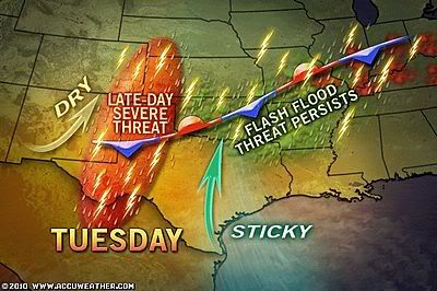
quote:More Severe Storms, Flooding to Pummel Kansas to Wisconsin
Areas from south-central Kansas to northern Wisconsin are at risk for severe storms that threaten to cause damage and flooding today.
A storm system cutting from the central Plains into the upper Great Lakes will be the culprit behind the violent weather, while moisture from the remnant low of Georgette adds to the risk of flooding across portions of the Plains and the Midwest.
Severe Storm Threat Today
Concerns with today's thunderstorms will be very large hail, locally damaging wind gusts, flooding downpours and isolated tornadoes.
Hail bigger than golf balls threaten to crack windshields and damage crops, while the strong wind gusts can topple trees and power lines in some communities.
Flash flooding of urban, low-lying and poor drainage areas is likely with the heavy downpours that develop. Motorists are urged to avoid driving over roadways covered by water, since that could be a life-threatening decision.
The heavy rain associated with dangerous storms will be visible on the Omaha Radar, the Wichita Radar, and the Minneapolis Radar as the day progresses.
Severe thunderstorms will shift eastward overnight, putting Kansas City, Mo., Des Moines, Iowa, and Madison, Wis., in the line of fire.
To the north of the battlegrounds for storms, a steadier, windswept rain will be unleashed across the northern Plains and the Upper Great Lakes region. Aberdeen, S.D., International Falls, Minn., and and Marquette, Mich., may deal with flooding.
Up to 4 inches of rain will soak the Dakotas to the Upper Peninsula of Michigan with the shield of rain.
Severe Storms Hit the Plains on Wednesday
Severe thunderstorms rumbled from central Nebraska to southern Minnesota on Wednesday, producing very large window-breaking hail, gusty winds, and flooding rainfall.
Hail up to the size of baseballs and even softballs fell in a few areas. Hail of 4.25 inches in diameter pounded an area 1 mile to the south of Crofton, Neb.
Flash flooding resulted 2-4 inches of rain that poured down from central Nebraska to southern Minnesota with Wednesday's thunderstorms. Some highways have been left under water and many homes have endured flooding in this corridor.
Accuweather


Tornadowaarschuwing voor New York
Het Amerikaanse National Weather Service heeft dinsdagochtend (lokale tijd) een tornadowaarschuwing uitgegeven voor onder andere de stad New York
De waarschuwing blijft in ieder geval van kracht tot zes uur dinsdagavond (lokale tijd) en geldt onder andere voor de wijken Bronx en Queens, maar ook voor andere delen van de staat New York.
Het instituut acht overstromingen als gevolg van hevige regenval mogelijk. Bovendien worden er windsnelheden tot 120 kilometer per uur verwacht en is er kans op zware onweersbuien.
De waarschuwing wordt uitgegeven terwijl veel wijken en steden nog bezig zijn met het herstellen van de schade als gevolg van het noodweer op 17 september, dat delen van New York lam legde.
http://www.nu.nl/buitenla(...)huwing-new-york.html
Life is Music

Tornado Intercept radardata - TVN
De heren van tornadovideos.net hebben vandaag voor het eerst een dataset met verticale windsnelheden vrijgegeven. De dataset bevat de eerste geslaagde metingen met de radar die bovenop de dominator staat. De getoonde snelheden zijn gemeten tijdens een intercept van een multivortex F4 tornado op 17 juni 2010 ten zuidwesten van Wadena MN.
Onderstaand is een overzicht van de gemeten verticale windsnelheden, op z'n top bereikte deze 170 mph (~275 km/u). Op datzelfde moment werden er windstoten tot 300 km/u gemeten door de windmeter op de dominator. In de grafiek is de horizontale balk de tijd in seconden en de verticale balk is de verticale windsnelheid.
Een absolute aanrader zijn de onderstaande beelden. Deze geven een goed beeld van de tornado waarin deze windsnelheden zijn gemeten. De intercept zelf is op deze beelden niet te zien, deze zullen te zijn zijn tijdens het nieuwe seizoen van Stormchasers, welke 13 oktober in premiere gaat in de VS. De verwachting is dat Stormchasers aan het eind van dit jaar of begin volgend jaar in Nederland word uitgezonden. Een exacte datum volgt nog
Enjoy!
©onweer-online
De heren van tornadovideos.net hebben vandaag voor het eerst een dataset met verticale windsnelheden vrijgegeven. De dataset bevat de eerste geslaagde metingen met de radar die bovenop de dominator staat. De getoonde snelheden zijn gemeten tijdens een intercept van een multivortex F4 tornado op 17 juni 2010 ten zuidwesten van Wadena MN.
Onderstaand is een overzicht van de gemeten verticale windsnelheden, op z'n top bereikte deze 170 mph (~275 km/u). Op datzelfde moment werden er windstoten tot 300 km/u gemeten door de windmeter op de dominator. In de grafiek is de horizontale balk de tijd in seconden en de verticale balk is de verticale windsnelheid.

Een absolute aanrader zijn de onderstaande beelden. Deze geven een goed beeld van de tornado waarin deze windsnelheden zijn gemeten. De intercept zelf is op deze beelden niet te zien, deze zullen te zijn zijn tijdens het nieuwe seizoen van Stormchasers, welke 13 oktober in premiere gaat in de VS. De verwachting is dat Stormchasers aan het eind van dit jaar of begin volgend jaar in Nederland word uitgezonden. Een exacte datum volgt nog
Enjoy!
©onweer-online

Weer of geen weer, altijd actueel www.onweer-online.nl

Steam Devils
Andrew Pritchard
Image taken: Oct. 3, 2010 Location: Deep Lake, Oxford, Wisconsin, USA
Details:
While at the lake house in central Wisconsin during the area's first hard freeze, temperatures plunged to at or below 30F. With water temperatures in the lake still above 60F, I figured photogenic morning steam would be a sure thing. I ended up with that and more, as steam devils, or little vortices in the steam started sprouting up around sunrise. Essentially these guys form under the same conditions that drive dust devils, as well as water spouts and land spout tornadoes, on a much much smaller scale of course. Little areas of vorticity would be present as the very light winds roll the steam across the lake surface, while little updrafts due to the instability in the lowest of levels stretches the vorticity into at times tight little circulations in the steam. Pretty mesmerizing stuff to watch as they really do resemble little water spouts. I ended up almost core punching one on the row boat just after sunrise and noticed they even created little "swirl" regions at the surface of the water and base of the vortex, exactly as water spouts do. Unfortunately this was too difficult to actually document visually. Video as well:


<a href="http://www.vwkweb.nl/" rel="nofollow" target="_blank">[b]Vereniging voor weerkunde en klimatologie[/b]</a>
<a href="http://www.estofex.org/" rel="nofollow" target="_blank">[b]ESTOFEX[/b]</a>
<a href="http://www.estofex.org/" rel="nofollow" target="_blank">[b]ESTOFEX[/b]</a>
Momenteel tornado warning in Arizona omgeving; Flagstaff.
Edit: 1 tornado is ook al confirmed
[ Bericht 31% gewijzigd door Drassss op 06-10-2010 16:56:04 ]

Edit: 1 tornado is ook al confirmed
[ Bericht 31% gewijzigd door Drassss op 06-10-2010 16:56:04 ]
Tornado warnings are in effect for Flagstaff, Sedona/Oak Creek Canyon and the area south of Tuba City.
BELLEMONT, Ariz. -- The National Weather Service has confirmed that two tornadoes touched down in the area of Interstate 40 between mileposts 180 and 190 west of Flagstaff Wednesday morning.
"That confirmation came because the tornado passed almost directly over our office here in Bellemont," said Dan LeBlanc of the National Weather Service.
The first hit Bellemont around 5:30 a.m. and the second touched down east of the small community about 45 minutes later. That's the one that passed by the NWS office. Damage to homes in the area is extensive with smashed windows and siding torn off some residences. Between 10 and 15 home are uninhabitable. Seven people reportedly were injured, but those injuries were not serious. No fatalities or missing persons have been reported.
The Red Cross is setting up a reception center at Flagstaff Middle School for some 30 people who have been displaced. That shelter should be operational by noon.
The Department of Public Safety reported several collisions in that area. No serious injuries were reported in those wreck. I-40 was closed for a time from Parks to the A-1 interchange, roughly milepost 170 to 190.
As of 10:15 a.m., Arizona Department of Transportation spokesman Doug Nintzel said I-40 was open between Flagstaff and Williams. Debris, however, was a major issue on several highways and roadways in the Flagstaff area, causing some significant backups. Drivers were being urged to go slowly and exercise extreme caution. DPS is advising people to avoid the area if possible. Crews were working to clear that debris. Intermittent closures are possible throughout the day.
According to Lena Kent off Burlington Northern Santa Fe, the severe weather up north derailed a 58-car train. One of the tornadoes blew 28 cars off the tracks. A crew of two was aboard the train at the time. Neither was hurt. The train, which was stopped in Bellemont because of the tornado warning, was heading east, hauling containerized cargo from ports in Los Angeles. It was not carrying any hazardous materials. Both the eastbound and westbound tracks are closed. Kent said crews are working to clear the tracks and expect to have them back open by midnight.
At the Camping World RV Park in Bellemont, some 30 RVs were blown over and the debris was scattered all over I-40.
DPS said a third tornado did hit the area, but the NWS has not yet confirmed that.
A tornado warning for central Coconino and northeastern Yavapai Counties, including Bellemont, expired at 8:15 a.m. Radar continues to show several super cells thunderstorms in central and north central Arizona capable of producing tornadoes with little or no advance notice, moving north-northeastward at approximately 50 mph.
Three new warnings were issued for Flagstaff, Sedona/Oak Creek Canyon and the area south of Tuba City shortly after 11 a.m. as a line of severe thunderstorms developed from east of Prescott to north to Bellemont and the Parks area.
The severe weather is expected to continue through Wednesday afternoon. A tornado watch continues for central and north-central Arizona until 5 p.m.
The Red Cross said it is on standby should a tornado touch down in Flagstaff.
A citizen hotline has been activated for the public to obtain information and updates about the emergency. The number is 1-888-679-8393.
In addition, an emergency operations center has been set up at the Sheriff’s Office in Flagstaff.
The Associated Press contributed to this report.
http://www.azfamily.com/w(...)staff-104414284.html
[ Bericht 1% gewijzigd door Drassss op 06-10-2010 20:44:57 ]
BELLEMONT, Ariz. -- The National Weather Service has confirmed that two tornadoes touched down in the area of Interstate 40 between mileposts 180 and 190 west of Flagstaff Wednesday morning.
"That confirmation came because the tornado passed almost directly over our office here in Bellemont," said Dan LeBlanc of the National Weather Service.
The first hit Bellemont around 5:30 a.m. and the second touched down east of the small community about 45 minutes later. That's the one that passed by the NWS office. Damage to homes in the area is extensive with smashed windows and siding torn off some residences. Between 10 and 15 home are uninhabitable. Seven people reportedly were injured, but those injuries were not serious. No fatalities or missing persons have been reported.
The Red Cross is setting up a reception center at Flagstaff Middle School for some 30 people who have been displaced. That shelter should be operational by noon.
The Department of Public Safety reported several collisions in that area. No serious injuries were reported in those wreck. I-40 was closed for a time from Parks to the A-1 interchange, roughly milepost 170 to 190.
As of 10:15 a.m., Arizona Department of Transportation spokesman Doug Nintzel said I-40 was open between Flagstaff and Williams. Debris, however, was a major issue on several highways and roadways in the Flagstaff area, causing some significant backups. Drivers were being urged to go slowly and exercise extreme caution. DPS is advising people to avoid the area if possible. Crews were working to clear that debris. Intermittent closures are possible throughout the day.
According to Lena Kent off Burlington Northern Santa Fe, the severe weather up north derailed a 58-car train. One of the tornadoes blew 28 cars off the tracks. A crew of two was aboard the train at the time. Neither was hurt. The train, which was stopped in Bellemont because of the tornado warning, was heading east, hauling containerized cargo from ports in Los Angeles. It was not carrying any hazardous materials. Both the eastbound and westbound tracks are closed. Kent said crews are working to clear the tracks and expect to have them back open by midnight.
At the Camping World RV Park in Bellemont, some 30 RVs were blown over and the debris was scattered all over I-40.
DPS said a third tornado did hit the area, but the NWS has not yet confirmed that.
A tornado warning for central Coconino and northeastern Yavapai Counties, including Bellemont, expired at 8:15 a.m. Radar continues to show several super cells thunderstorms in central and north central Arizona capable of producing tornadoes with little or no advance notice, moving north-northeastward at approximately 50 mph.
Three new warnings were issued for Flagstaff, Sedona/Oak Creek Canyon and the area south of Tuba City shortly after 11 a.m. as a line of severe thunderstorms developed from east of Prescott to north to Bellemont and the Parks area.
The severe weather is expected to continue through Wednesday afternoon. A tornado watch continues for central and north-central Arizona until 5 p.m.
The Red Cross said it is on standby should a tornado touch down in Flagstaff.
A citizen hotline has been activated for the public to obtain information and updates about the emergency. The number is 1-888-679-8393.
In addition, an emergency operations center has been set up at the Sheriff’s Office in Flagstaff.
The Associated Press contributed to this report.
http://www.azfamily.com/w(...)staff-104414284.html


[ Bericht 1% gewijzigd door Drassss op 06-10-2010 20:44:57 ]


quote:4 tornado's treffen Arizona op één dag
De Amerikaanse staat Arizona werd gisteren op één dag tijd door liefst vier tornado's getroffen. De wervelwinden richtten over de gehele staat aanzienlijke schade aan.
De tornadozwerm is een zeldzaam fenomeen in Arizona. Normaal krijgt de staat op een heel jaar slechts van hooguit vier tornado's bezoek. Gisteren was dus een bijzondere dag in Arizona, met liefst 22 waarschuwingen voor extreme weersomstandigheden. Gelukkig vielen er geen dodelijke slachtoffers, al hebben de stormen wel veel huizen en auto's vernield.
De inwoners van Bellemont werden geëvacueerd en zeker 30 huizen werden zwaar beschadigd door de storm. Een camping nabij de Interstate 40 werd eveneens niet gespaard. Tientallen kampeerwagens werden ondersteboven geblazen. Brokstukken vlogen de baan op, met zware files tot gevolg. Ook treinen ontspoorden door de tornado's.
De tornado's zijn het gevolg van een actief weersysteem dat boven het centrum en zuiden van Californië hangt. Eerder deze week veroorzaakte de storing ook al een recordhoeveelheid neerslag in Nevada. In Utah werden twee tieners dinsdag net buiten hun school door de bliksem getroffen

Dat is wel heel bijzonder. Nu zit ik met smart op beelden te wachten :pquote:
Ik ben illegaal!
Op woensdag 1 december 2010 16:07 schreef honkeytonk het volgende:Ik denk zelfs dat ze achter de schermen een fantopic over mij hebben geopend :Y
Op woensdag 1 december 2010 16:07 schreef honkeytonk het volgende:Ik denk zelfs dat ze achter de schermen een fantopic over mij hebben geopend :Y
http://www.azfamily.com/w(...)staff-104414284.htmlquote:Op zaterdag 9 oktober 2010 11:16 schreef Ploertendoder het volgende:
[..]
Dat is wel heel bijzonder. Nu zit ik met smart op beelden te wachten :p
Bekijk dat filmpje
aardig heftigquote:Op zaterdag 9 oktober 2010 11:36 schreef Drassss het volgende:
[..]
http://www.azfamily.com/w(...)staff-104414284.html
Bekijk dat filmpje
Ik ben illegaal!
Op woensdag 1 december 2010 16:07 schreef honkeytonk het volgende:Ik denk zelfs dat ze achter de schermen een fantopic over mij hebben geopend :Y
Op woensdag 1 december 2010 16:07 schreef honkeytonk het volgende:Ik denk zelfs dat ze achter de schermen een fantopic over mij hebben geopend :Y
Volg jij doppler nu ook? Flinke squall line daar zo te zien, al heb ik er niet zo heel veel verstand van. Mesocycloon ook al waargenomen op radar. Gaat aardig los in die regio!quote:Op dinsdag 12 oktober 2010 18:26 schreef Drassss het volgende:
Ik vermoed de komende uren weer wat tornado's. Dit keer in Mississippi/Lousiana.
Ik volg het, maar tot nu toe alleen nog "maar" zware onweersbuien op mijn radar.quote:Op dinsdag 12 oktober 2010 21:54 schreef Disorder het volgende:
[..]
Volg jij doppler nu ook? Flinke squall line daar zo te zien, al heb ik er niet zo heel veel verstand van. Mesocycloon ook al waargenomen op radar. Gaat aardig los in die regio!
Paarse icoontje voor mesocycloon vlakbij de grond nu. Redelijke kans op tornado nu, lijkt me. Is dat een squall line trouwens? Ik probeer dit te leren. Gebruik jij ook GRlevel3?quote:Op dinsdag 12 oktober 2010 22:25 schreef Drassss het volgende:
[..]
Ik volg het, maar tot nu toe alleen nog "maar" zware onweersbuien op mijn radar.
Hehe, hoho. Zo profi ben ik ook weer nietquote:Op dinsdag 12 oktober 2010 22:35 schreef Disorder het volgende:
[..]
Paarse icoontje voor mesocycloon vlakbij de grond nu. Redelijke kans op tornado nu, lijkt me. Is dat een squall line trouwens? Ik probeer dit te leren. Gebruik jij ook GRlevel3?
Ik bekijk het puur op deze site:
http://www.news9.com/Global/category.asp?C=167025
2% kans op een tornado volgens hun dus we wachten rustig af.
JACKSON, Miss. (AP) Officials say a line of severe weather moving across Mississippi downed power lines and trees in parts of the state.
National Weather Service forecaster Brad Bryant said there were scattered reports of wind damage and hail across north Mississippi on Tuesday. He says downed trees and power lines were reported in the Delta city of Greenville.
Greenville Police Department dispatcher Roslyn Boston says there was minimal damage in the city. She says no injuries have been reported.
The rain was welcomed by many. Mississippi has been under a burn ban because of dry conditions.
http://www2.wjtv.com/jtv/(...)ines-in-miss/206217/
Nog ergens een tornado aan de grond geweest gisteravond? Heb de warning nog meegekregen maar meer ook niet.
Ik heb even snel de news channels van de 2 staten bekeken waar alles zat.. niks gevonden.quote:Op woensdag 13 oktober 2010 09:40 schreef Disorder het volgende:
Nog ergens een tornado aan de grond geweest gisteravond? Heb de warning nog meegekregen maar meer ook niet.
Weet niet of het goed staat, maar zou het anders ook niet weten waar ik het neer moet zetten. Een nieuw topic vond ik overbodig.
Blikseminslag in Vrijheidsbeeld?
Een fotograaf uit New-York heeft er 40 jaar over gedaan om een goede foto te maken van het Vrijheidsbeeld in combinatie met bliksem. Jay Fine had de avond in Battery Park City, Manhattan doorgebracht om deze schitterende foto vast te leggen. Jay maakte in totaal 80 foto's in een tijdsbestek van 2 uur. De foto is gemaakt op 22 september omstreeks 20.45 uur. Jay legde de foto vast met een Nikon D300s in combinatie met 60mm f/2.8 lens. Diafragma: f/10, Sluitertijd: 5 seconden, ISO: 200.

Weer of geen weer, altijd actueel www.onweer-online.nl
Mooie fotoquote:Op donderdag 14 oktober 2010 00:37 schreef meteo-online het volgende:
Weet niet of het goed staat, maar zou het anders ook niet weten waar ik het neer moet zetten. Een nieuw topic vond ik overbodig.
Blikseminslag in Vrijheidsbeeld?
Een fotograaf uit New-York heeft er 40 jaar over gedaan om een goede foto te maken van het Vrijheidsbeeld in combinatie met bliksem. Jay Fine had de avond in Battery Park City, Manhattan doorgebracht om deze schitterende foto vast te leggen. Jay maakte in totaal 80 foto's in een tijdsbestek van 2 uur. De foto is gemaakt op 22 september omstreeks 20.45 uur. Jay legde de foto vast met een Nikon D300s in combinatie met 60mm f/2.8 lens. Diafragma: f/10, Sluitertijd: 5 seconden, ISO: 200.
[ afbeelding ]
Momenteel toch weer wat zware onweersbuien in Oklahoma/Texas en New Mexico. Flink wat spotters die aan het rondrijden zijn dus het kan misschien wat worden.
Tornado warning in west Texas.
http://weather.wdtinc.com/popout/?M=10220&C=20211&O=10008&P=true
Je kan wel de wolk zien, maar het is een verschrikkelijke Live video..
http://weather.wdtinc.com/popout/?M=10220&C=20211&O=10008&P=true
Je kan wel de wolk zien, maar het is een verschrikkelijke Live video..
Is er nog een tornado gezien? Ik meen een zogenaamde 'hook echo' te hebben gezien in Texas rond kwart voor twaalf gisteravond. Kenmerkend voor tornado's. Niet veel later kwam die warning.
quote:Ja ik ook. Bepaalde hook die er toch bijzonder uit zag op de radar. Ik keek nog even via een channel van een spotter, maar daar was niks te zien.. Eventjes de newschannels bekijken.Op vrijdag 22 oktober 2010 08:23 schreef Disorder het volgende:
Is er nog een tornado gezien? Ik meen een zogenaamde 'hook echo' te hebben gezien in Texas rond kwart voor twaalf gisteravond. Kenmerkend voor tornado's. Niet veel later kwam die warning.
2010 tornado stats through May
Dr. Forbes, Severe Weather Expert, The Weather Channel
Oct. 18, 2010 11:17 am ET
Tornado statistics are provided by The Weather Channel's severe weather expert Dr. Greg Forbes who closely analyzes and documents confirmed tornadoes throughout the year.
2010 Forbes' Tornado Count
January 28
February 1
March 30
April 137
May 258
January through May 454
2010
10-Year Average
January 22
February 37
March 90
April 163
May 291
January through May 603
2010
Departure from Average
January 27%
February -97%
March -67%
April -16%
May -11%
January through May -25%
June Tornado Stats
June has averaged 217 tornadoes over the past 10 years through 2010.
There were 270 tornadoes in June 2009.
June 1992 had the most on record, with 399.
2010 Killer Tornadoes
There have been 7 killer tornadoes in the United States through May 31, 2010 leading to 18 deaths.
Below is a list of the killer tornadoes including the location, strength of tornado and attributed fatalities.
March 10 - Pearson, Cleburne County, Arkansas - EF2, 1 killed
April 24 - Yazoo County (4), Choctaw County (5) and Holmes County, Mississippi (1); total 10
April 30 - Van Buren County, Arkansas (1) EF3
May 2 - Lafayette County, Mississippi (1) EF2
May 2 - Benton County, Mississippi (2) and Hardeman County, Tennessee (1) from EF3 tornado
May 10 - Oklahoma County, Oklahoma (1) from EF3
May 10 - Cleveland County, Oklahoma (1) from EF3
Bron: http://www.weather.com/newscenter/stormwatch/
Puur wat cijfers van dit jaar ( tot aan mei ).
Momenteel weer kans op zwaar weer ( 5% kans op tornado's ) in Oklahoma/Texas.
1ste severe thunderstorm warning uitgeven ZW van Oklahoma City.
1ste severe thunderstorm warning uitgeven ZW van Oklahoma City.
OKLAHOMA CITY -- Weather forecasters say an isolated tornado is possible as a strong storm system moves across Oklahoma. National Weather Service meteorologist Doug Speheger said Friday that tornadic activity is not common in Oklahoma in October, but is not unheard of. Since 1950 there has been an average of about two tornadoes in October with 40 of those 60 years having none or one twister.
Bron: http://www.kfor.com/news/(...)tory,0,7396955.story
Momenteel tornado watch zuidwest Oklahoma
Bron: http://www.kfor.com/news/(...)tory,0,7396955.story
Momenteel tornado watch zuidwest Oklahoma
Weer een dag met kans op slecht weer en misschien tornado's ( 5% ).
Momenteel tornado warning in Zuid-Texas.
[ Bericht 32% gewijzigd door Drassss op 23-10-2010 14:37:24 ]
Momenteel tornado warning in Zuid-Texas.

[ Bericht 32% gewijzigd door Drassss op 23-10-2010 14:37:24 ]
Ik val in herhaling:
Vandaag een zeer grote kans op slecht weer in Indiana ( High risk ). 15% kans op tornado's.
Edit: Mogelijkheid op zeer grote tornado's.
1ste tornado-warning al in Missouri.
Severe Weather Outbreak Possible Tuesday
By Scott Sarvay
Severe Weather Outbreak Possible Tuesday
Related:
* Severe Winds Information
October 25, 2010
FORT WAYNE, Ind. (Indiana's NewsCenter) - Not just high winds, but we could see a severe weather outbreak Tuesday in parts of Indiana. "You'll want to pay attention to this one," says Indiana's NewsCenter Chief Meteorologist Curtis Smith.
"We'll have strong winds, for sure, mainly Tuesday afternoon," says Curtis, who along with his team of meteorologists Chris Daniels and Jason Meyers have been monitoring the development of a powerful low pressure system in the upper plains that is pushing a strong cold front into Indiana. Winds of 30 miles an hour will be common, and gusts to 50 miles an hour in parts of Indiana expected.
*
Digital Daily – subscribe to our daily newsletter
Using exclusive Pinpoint VIPIR HD and AccuWeather, Indiana's NewsCenter forecasters expect a big change in our weather over the next few days. "High winds will be the biggest concern," says meteorologist Chris Daniels. He says forecasters refer to lower pressure systems like this one with sinking air 'a bomb,' because of the powerful effect it creates.
Along that cold front, thunderstorms are expected to develop and push rapidly across the state. "Fueling all of this has been warm air being pushed up from the Gulf," says meteorologist Jason Meyers. Isolated tornadoes are possible.
Meteorologist Chris Daniels starts Tuesday morning with your updated forecast on www.incnow.tv, and on INCToday at 5 A.M. on the networks of Indiana's NewsCenter.
You can track the storms by clicking here to control your own "Interactive VIPIR." And stay ahead of the storms with weather text alerts.
If you have pictures of storm damage, send it to Indiana's NewsCenter.
Bron: http://www.indianasnewsce(...)esday-105715913.html
[ Bericht 56% gewijzigd door Drassss op 26-10-2010 10:32:32 ]
Spannend. Vanavond even volgen op mijn iPod met mijn storm tracker aangezien mijn GRlevel3 trial is opgehouden 
quote:Complex gaat vanaf nu tot een uurtje of 8 Nederlandse tijd huishouden in Indiana... Erg bevolkt gebied dus dat is niet best.Op dinsdag 26 oktober 2010 12:35 schreef Disorder het volgende:
Spannend. Vanavond even volgen op mijn iPod met mijn storm tracker aangezien mijn GRlevel3 trial is opgehouden
Edit: De één na de andere tornado warning momenteel.. Behoorlijk serieus. Nadeel van de oostelijke staten, die geilen minder op het weer en komen dus niet met televisie camera's aanzetten.

9 tornado warnings.
[ Bericht 11% gewijzigd door Drassss op 26-10-2010 16:12:58 ]
quote:Ik zie het nu. Gaat erg hard. Maar ik denk dat we pas van een outbreak mogen spreken wanneer ze ook allemaal de grond raken, toch?
[..]
Ik weet niet of je zit te kijken, maar er zijn wel 20 tornado warnings nuOngelofelijk.
http://www.cnn.com/video/(...)tream=stream1&hpt=T1
Live beelden nu op bovenstaande link.
CNN zegt al dat er meerdere tornado's zijn geweest. Ik denk dat het toch naar een outbreak gaat hoor.
Live beelden nu op bovenstaande link.
CNN zegt al dat er meerdere tornado's zijn geweest. Ik denk dat het toch naar een outbreak gaat hoor.
http://news.blogs.cnn.com(...)pper-midwest/?hpt=T1
Artikel met alle tornado's die de grond hebben geraakt ( volgens hun bronnen ).
Artikel met alle tornado's die de grond hebben geraakt ( volgens hun bronnen ).
quote:Thousands without power
High winds, heavy rain and severe thunderstorms are racing eastward through Greater Cincinnati and Northern Kentucky. Power has been knocked out to more than 50,000 Duke Energy customers.
The northern Butler County city of Trenton reported 79 mph wind gusts, according to the National Weather Service. Winds have been reported whipping 57 mph at the Cincinnati/Northern Kentucky International Airport.
CVG spokeswoman Barb Schempf said that as of 1:22 p.m., all normal operations have resumed at CVG. Power has been fully restored and passengers are no longer being moved away from windows and are now boarding planes.
A line of thunderstorms continues to move east at 50 mph. The storm passed through downtown Cincinnati about 12:30 p.m.
Sirens were sounded in Butler County because tornados were possible inside severe thunderstorms. Some trees were knocked over. Students at Miami University in Oxford were alerted to severe weather.
Fairfield schools cancelled afternoon kindergarten and the busing of Fairfield kindergarten students home was delayed until storm passes, say school officials. Students at Fairfield High School were moved to safe zones of the building. Monroe Schools in Butler County evacuated students from portable classrooms outside main school buildings. Students at Kings and Little Miami schools were also moved to safe spaces.
Boone County High School went on "tornado lock down." Afternoon dismissals were delayed until the weather improves. Power is out at the Boone County Justice in Burlington and at McGlasson's Farm in Hebron.
In the Cincinnati Public School District, Sayler Park students have been evacuated to the Sayler Park Community Center, according to district spokeswoman Janet Walsh. The school is temporarily relocated in modular classrooms while their main school building is renovated.
Students and staff at the College of Mount St. Joseph in Delhi Township took shelter in basements as the storm passsed over.
In the span of an hour, the number of Duke Energy customers without power went from 1,354 to 52,724. The most impacted county is Hamilton with 26,098 customers out of power as of 1 p.m.
Several traffic lights are not operating and roads are flooding in the Hyde Park area as well as areas west of downtown.
A tornado watch remains in effect through 4 p.m. for Greater Cincinnati, Northern Kentucky and southeastern Indiana. A high wind warning is in place in the region until 8 p.m.
"This is a very energetic storm system," said NWS meteorologist Allen Randall


quote:Zwaarste storm in zeventig jaar zet 200.000 gezinnen zonder stroom
Een zware storm heeft dinsdag lelijk huisgehouden in het midden van de Verenigde Staten. Tot 200.000 huishoudens zitten zonder elektriciteit, zo bericht de Amerikaanse zender CNN. Ook Canada werd getroffen door het noodweer.
De storm verstoort ook het verkeer: op de luchthaven van Chicago zijn honderden vluchten geannuleerd. Het bootverkeer op de Grote meren ligt stil. Op Lake Superior worden golven tot acht meter hoog verwacht.
Minstens twee tornado's
De wind haalde orkaansnelheden. In de staat Illinois is er sprake van de zwaarste storm in zeventig jaar. Er zijn minstens twee tornado's geteld. Er vielen tot nu toe geen doden of zwaargewonden. De zwaarst getroffen staten zijn Ohio, Indiana, Michigan, Kentucky en Illinois.
'Erg intense' storm in Canada
Meer dan 17.000 inwoners van de Canadese provincie Ontario zaten gisteravond zonder elektriciteit door de doortocht van de zware storm.
De meteorologische diensten in Canada verwachtten "een erg intense storm, ongewoon voor het seizoen", met windsnelheden tot 100 kilometer per uur. De storm woedde onder meer boven Toronto, de grootste stad van het land, en zou nadien richting hoofdstad Ottawa trekken

(CNN) -- Spawning at least 24 possible tornadoes, mostly in the Midwest, a giant storm system stretched Tuesday night from Alabama to Maryland, bringing new watches and warnings.
The system unleashed its wrath on several communities in northern Alabama, Tennessee and North Carolina on Tuesday night.
At one time, it had stretched a staggering 1,200 miles from north to south.
Tornado watches were in effect for several counties near Charlotte, North Carolina, and forecasters say some areas will see continued strong winds Wednesday.
In Lincoln County, North Carolina, five homes were damaged and two of them destroyed, said spokesman Dion Burleson. Five people were hurt; one has life-threatening injuries. Several cars were overturned in Catawba County, according to the National Weather Service.
In Chattanooga, Tennessee, a possible tornado struck a fence near Chickamauga Dam and threw debris into a roadway, police said. Seven cars lost control and crashed, with five people suffering injuries.
Deputies were assessing damage near the town of Geraldine in DeKalb County, Alabama, and in Marshall County, said Lauree Ashcom, spokeswoman for the Alabama Emergency Management Agency. Marshall includes the lake resort city of Guntersville. A tornado may have touched down southwest of Geraldine, she said.
Video: Storms tear through Midwest
Downed trees are making it difficult to reach residents and determine any injuries, said DeKalb County emergency official Michael Leath. "We're having to batten down the hatches for another system coming in." No injuries had been reported late Tuesday.
A tornado watch was in effect for the District of Columbia until 3 a.m. ET Wednesday.
Wind, rather than flooding, appeared to be the biggest danger, with gusts exceeding 70 mph in some places. The National Weather Service's Storm Prediction Center said there were 258 reports of wind damage by mid-evening Tuesday.
No deaths had been reported to state emergency officials by early evening.
Extensive damage from the high winds and possible tornadoes was reported in a band from Minnesota to the Gulf Coast.
Six tornadoes were confirmed in Indiana, three in Ohio and another in Wisconsin.
Up to 200,000 residents lost electrical power.
A tornado smashed into a business in LaPorte County, Indiana.
Dan Hill, general manager of Hoosier Machinery Solutions, heard a weather siren and went to check.
He turned to another employee after spying an odd cloud formation outside the business door. " 'Does that look like a tornado?' I asked. As soon as I said that, it touched down."
The twister tore a roof off a pole barn, damaged some reconditioned recycling equipment and employees cars. No one was hurt. The 10 employees "all ran for [heavy] equipment and got inside," Hill told CNN.
All 48 floors of the Chase Tower in downtown Indianapolis were evacuated for a short time at the height of the storm. People took refuge in the building's fallout shelter, according to CNN affiliate WRTV.
The system appears to have made weather history. Preliminary readings indicate that a new record was set for the lowest pressure in a nontropical storm in the mainland United States, said Chris Vaccaro of the National Oceanic and Atmospheric Administration.
The minimum central pressure of 28.22 inches of mercury was equivalent to the pressure of a major Category 3 hurricane, without the corresponding wind scale, he said. If confirmed, the reading would break the current record of 28.28 inches, set on January 26, 1978, during what became known as the Blizzard of 1978.
Storms caused extensive damage to buildings near Racine, Wisconsin, and Peotone, Illinois, Tuesday morning.
A Peotone youth who was with his brother at a farm that was damaged described to CNN affiliate WLS-TV in Chicago what it was like in the middle of the tempest.
"All of a sudden, the wind kicked up," Justin Schroeder said. He said the force of the wind "sent us back into the foyer about five feet. It was like a bomb went off. You didn't hear a tornado. You didn't hear a whistle. It was a like an explosion of glass."
Some experts told WLS that the storms might be the most powerful to hit Illinois in more than 70 years. The CNN Severe Weather Center reported the storm was moving quickly eastward at more than 50 mph.
The Minneapolis/St. Paul Airport reduced air traffic from three runways to one runway for landings and takeoffs Tuesday mid-afternoon because of high winds. About 50 flights had been canceled or delayed, a spokesman said. Conditions may still be difficult in the region Wednesday.
O'Hare International Airport in Chicago reported that 500 flights had been canceled as of 3:35 p.m. Some delays were reported at Chicago Midway Airport. Indianapolis International Airport reported some delays for flights to Detroit, Michigan; Milwaukee, Wisconsin; Cleveland, Ohio; and Minneapolis, Minnesota, while Detroit Metro Airport said most flights were on time with the most significant delays to O'Hare.
Indiana and Illinois each had at least 60,000 power outages and 38,000 were reported in Ohio. Other states reported smaller figures.
Gabrielle Torres and her husband experienced extreme weather in Corydon, Indiana.
"There were extremely strong winds that were even rocking my husband's semi-truck side to side," she said. "The tornado sirens were sounding but we could barely hear them over the pounding rain."
In St. Louis, Missouri, two reported partial building collapses were blamed on the extreme weather, according to Officer Donna Wisdom of the St. Louis Police Department. Video from CNN affiliate KSDK-TV in St. Louis showed downed trees, damage to homes and thick rubble on a sidewalk beside a building damaged in the storm. Wisdom said no serious injuries were reported from the partial collapses.
A National Weather Service damage assessment team confirmed that an tornado touched down near Somers, Wisconsin, causing two injuries.
Numerous uprooted trees, snapped and downed power poles and roof damage to several buildings was reported. Several parked tractor-trailers were also tipped over, according to the National Weather Service.
Severe thunderstorm warnings and tornado watches popped up throughout central Kentucky, Ohio and Tennessee around midday Tuesday as the intense band of storms began to push through Indiana.
At least one tornado was reported to have severely damaged a house in Howard County, northeast of Kokomo, according to CNN affiliate WRTV in Indianapolis.
Witnesses gave accounts that underscored the fury of the storm. Several said they'd never seen anything like it.
CNN iReporter Trey Sturgeon, 23, of Connersville, Indiana, described the wind and rain as "a little bit scary."
"Where I live in Indiana, we don't get winds and possible tornadoes," said Sturgeon, a musician who was at home when he looked out the window to see the storm.
"The first thing I thought of was my family," he said.
"When the winds came, it was a lot more like a dense fog than rain -- from the wind pushing the rain sideways," he said.
"On a tree right down the road, a big tree limb was broken off and it blew across the street before it hit the ground, and we're talking maybe a 200-, 250-pound tree limb. There were reports on my police scanner of tree limbs falling and landing on power lines in the northern part of the county."
All 48 floors of the Chase Tower in downtown Indianapolis were evacuated briefly at the height of the storm, and occupants took refuge in the building's fallout shelter, WRTV reported.
"It was pretty bad up there," Nick Hoetmer, who works in the building, told WRTV. "The windows were moving back and forth, so it was nasty."
CNN meteorologist Sean Morris and CNN's Dave Alsup, Shawn Nottingham, Michael Martinez and Kara Devlin contributed to this report.
Bron: http://www.cnn.com/2010/U(...)er/index.html?hpt=T2
't Was weer raak ja vandaag in het Midwesten. Twee keer gingen de sirenes vanwege een mogelijke tornado. Zie ook wat er met m'n boom aan de hand is:
Foto's van je mooie buitenlandse optrekje deeltje 2
Maar goed, het kan natuurlijk veel erger. Ik zie onderweg naar huis rijdend erg veel 'destruction'.
Foto's van je mooie buitenlandse optrekje deeltje 2
Maar goed, het kan natuurlijk veel erger.
Patience is not one of my virtues, neither is memory. Or patience for that matter.
Zeg wat kost dat nou eigenlijk, zo'n tornado chase vakantie? Wordt dat ook vanuit Nederland georganiseerd?
http://www.stormchasing.com/schedule.htmlquote:Op maandag 1 november 2010 08:21 schreef Disorder het volgende:
Zeg wat kost dat nou eigenlijk, zo'n tornado chase vakantie? Wordt dat ook vanuit Nederland georganiseerd?
Prijzig. Maar wel de moeite waard lijkt me. Al zie je alleen maar een mooie supercel, toch erg bijzonder. Iemand hier die met zo'n tour is meegeweest?
Tja de moeite waard? Je moet maar net geluk hebben met het weer. Het kan ook zomaar 1 week erg rustig zijn hequote:Op maandag 1 november 2010 09:43 schreef Disorder het volgende:
Prijzig. Maar wel de moeite waard lijkt me. Al zie je alleen maar een mooie supercel, toch erg bijzonder. Iemand hier die met zo'n tour is meegeweest?
Ik heb er een half jaar gewoond ( Oklahoma ) en heb toch een aantal stormen over me heen gehad. 1 tornado warning meegemaakt. Tornado zelf ging 5 mijl noord van me voorbij. Dag erna zag je van een aantal woningen alleen de fundering nog staan....
De kracht van alleen al onweersbuien is al zo machtig om mee te maken. Dat maken wij hier om de 5 jaar 1x mee, maar daar is het normaal en eigenlijk niks bijzonders.