WKN Weer, Klimaat en Natuurrampen
Lees alles over het onstuimige weer op onze planeet, volg orkanen en tornado's, zie hoe vulkanen uitbarsten en hoe Moeder Aarde beeft bij een aardbeving. Alles over de verwoestende kracht van onze planeet en tal van andere natuurverschijnselen.


Eerste extreem onweer
In ons eigen land is het momenteel rustig lenteweer met veel zon en middagtemperaturen die iets boven normaal liggen voor de tijd van het jaar. Rustig is het bepaald niet aan de andere kant van de Atlantische Oceaan. In het zuidoosten en oosten van de Verenigde Staten was het afgelopen week zeer onstuimig. De eerste hevige onweersbuien raasden over diverse staten van het zuidelijk gelegen Louisiana tot in het noordoostelijk gelegen Maryland en vrijwel alle staten ten zuidoosten van die lijn. Ongeveer 1300 zogeheten ‘trained spotters’ namen binnen 24 uur windschade, verschillende tornado’s en waterhozen of hevig onweer waar. De eerste onweerssituatie van het seizoen gaat dan ook meteen de recordboeken in, niet per se voor de grote hoeveelheid blikseminslagen of de verschillende tornado’s, maar vooral voor de extreme windsnelheden die soms opliepen tot 136 kilometer per uur.
Vanuit het warme Caribische gebied werd die dag vrij warme lucht in de zuidoosthoek van de Verenigde Staten aangevoerd, maar tegelijkertijd trok vanuit het noorden een koufront deze regio binnen. De zeer warme Caribische lucht en de nog winterkoude lucht vanuit onder andere Canada botsten langs een bijna 1500 kilometer lange lijn van de staat Louisiana tot aan Maryland op elkaar, die daarna verder activerend naar het zuidoosten richting de oostkust trok. Koude lucht is zwaarder en de warme Caribische lucht schoof dan ook met hoge snelheid omhoog over de koude lucht heen. Snel stijgende, warme en bovendien vochtige lucht zijn de 3 ultieme ingrediënten voor hevige buien of in dit geval een buienlijn.
Die lijn resulteerde op veel plaatsen in die hoek van Amerika in extreem weer. Er zijn in de zeer korte tijd dat de lijn overtrok 626 extreem weer waarschuwingen uitgegeven. Het onweerde bijna aan één stuk door en ongeveer 340.000 keer bereikten bliksemflitsen de aarde tijdens de buien. Ook werden hagelstenen van bijna 8 centimeter in diameter waargenomen en kwam het rond 26 keer tot tornado’s en nog diverse keren tot zogeheten tuba’s (een funnel cloud, ofwel een tornado die de grond niet raakt) en waterhozen.
Trained spotters
Bij Meteo Consult maken we voor onze verwachting dagelijks gebruik van meetgegevens en data van een groep vaste waarnemers. Deze hebben vaak een weerstation in de tuin of op het dak staan en mailen deze gegevens aan ons door. Ook bij extreem weer laten zij vaak van zich horen en dagelijks komen bovendien honderden foto’s binnen van weerliefhebbers en waarnemers. Deze waarnemers bevinden zich op allerlei verschillende plaatsen van het land en naast de officiële modelgegevens geven hun gegevens een duidelijk beeld van de situatie op een bepaald moment. Ook gebruiken we de gegevens van het waarnemersnetwerk van Het weer actueel.
In de Verenigde Staten werken weerbureaus samen met zogeheten ‘trained weather spotters’. Dit zijn waarnemers die hun gegevens doorsturen, maar het woord ‘trained’ laat al zien dat deze waarnemers er voor opgeleid zijn. De NWS, National Weather Service’ organiseert eens in de zoveel tijd een gratis cursus over de structuren en vorming van hevige onweer- of hagelbuien, maar ook de vorming van een tornado of een orkaan komt in de cursus aan bod. In principe kan iedereen naar deze cursussen, maar vaak zijn het mensen die op wat voor een manier dan ook al met het weer bezig zijn voor hun werk, zoals brandweermannen of mensen die in de wegenbouw zitten. Zij leren in deze cursussen om de horizon te scannen naar omstandigheden en voorwaarden die zouden kunnen leiden tot trechterwolken (tuba), arcus (shelfcloud), een tornado, etc. Na zo’n training krijgen zij een identificatienummer en deze gebruiken zij in het waarnemingsnetwerk van ruim 280.000 personen in de hele USA.
Recordhoogte
Tijdens de hevige buien van afgelopen 4 april kwamen ruim 1300 rapporten vanuit allerlei hoeken in het zuidoosten en oosten van de Verenigde Staten binnen. Alleen al voor extreem weer kwamen 626 meldingen binnen. Hiermee komt deze dag uit op de derde plek in de recordboeken in de lijst van meest actieve ‘zwaar weer dagen’. Op de eerste plaats staat het extreme weer op 7 april 2006, toen kwamen meer dan 700 meldingen binnen.
bron

Lol dat spektakel ken ik, vorig jaar ook vele malen afgekondigd, maar toen kwam er ook niets. Als er 2% kans was op een tornado gebeurde t meeste daarquote:Op vrijdag 8 april 2011 20:09 schreef Burnie88 het volgende:
Jaja, het wordt spektakel dit weekend in de VS!
Weer of geen weer, altijd actueel www.onweer-online.nl
Ja dat is waar. Laat ik het zo zeggen; alle ingrediënten zijn aanwezig voor heftig weer.quote:
[..]
Lol dat spektakel ken ik, vorig jaar ook vele malen afgekondigd, maar toen kwam er ook niets. Als er 2% kans was op een tornado gebeurde t meeste daar
's Avonds een man, overdags rustig an
Verwachting is toch dat er grote tornado's gaan ontstaan in de staat Wisconsin, met extreme hagel/wind.
Upper Midwest Faces Worst of Today's Tornado Outbreak
The atmosphere is ripe for an outbreak of destructive tornadoes and violent thunderstorms to ignite across the Heartland of the U.S. this afternoon and tonight, with the greatest threat centered over the Upper Midwest.
"There is potential for loss of life and widespread destruction is some communities," AccuWeather.com Expert Senior Meteorologist Alex Sosnowski warned about the impending outbreak.
The severe weather event will get under way this afternoon as intense thunderstorms erupt from southeastern Minnesota and western Wisconsin to northeastern Texas.
The violent thunderstorms will then shift to lower Michigan, the lower Ohio Valley and central Texas as tonight progresses.
The threat for destructive tornadoes will be highest this afternoon and evening before the violent thunderstorms form into a more organized squall line.
While an isolated tornado cannot be ruled out as far south as Texas, the Upper Midwest is where the atmosphere will fuel the development of multiple strong and long-tracking tornadoes.
More specifically, the greatest threat to lives and property from the tornadoes will encompass southeastern Minnesota, a large portion of Wisconsin, eastern Iowa and northwestern Illinois.
Cities at risk include Minneapolis, Minn., Rochester, Minn., Eau Claire, Wis., Madison, Wis., Cedar Rapids, Iowa, and Rockford, Ill. This zone lies just south of Duluth, Minn.
The tornadoes could leave a trail of damage similar or worse than what was reported across western Iowa Saturday evening.
Fortunately, no lives were lost due to Saturday's tornadoes. Residents across the nation's Heartland should heed tornado safety tips and tornado warnings to assure the same can be said for later today.
However, Sosnowski cautioned that "you don't have to be hit by a tornado to have major damage or to be at risk for injury."
In addition to spawning tornadoes, any of the strongest thunderstorms from the Upper Midwest to Texas will be capable of unleashing damaging winds, golf ball- to baseball-sized hail, flash flooding and frequent lightning.
All of the severe weather-related injuries on Saturday were the result of either damaging winds or a lightning strike, not tornadoes.
Strong winds within violent thunderstorms can do more than litter yards and roads with trees and power lines. Semi-trucks and campers can get overturned. Falling trees could cause bodily harm or death, even to those in cars.
The threat for the severe thunderstorms will not end with the weekend. On Monday, the danger zone will shift to the Ohio Valley and Deep South.


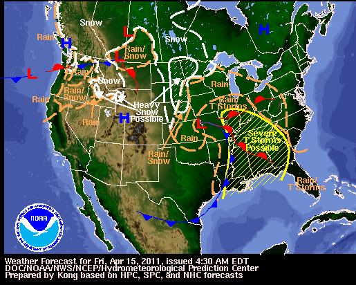
Gister 7 tornado reports.. vandaag verwacht men weer een outbreak. De lijn is verschoven naar het oosten en onder andere Mississippi & Tennessee gaan er flink van langs krijgen.

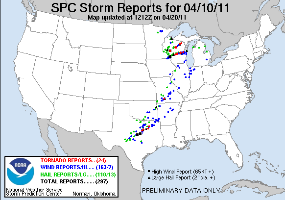
Mooie cel!quote:Op zondag 10 april 2011 21:54 schreef meteo-online het volgende:
Gisteren....
[ afbeelding ]
[ afbeelding ]
[ afbeelding ]
[ afbeelding ]


Jep en kans op krachtige tornado's/ flinke hagel en wind.. Het daar pas laat in de middag/avond gaan gebeuren dus dat is voor ons rond middernacht.quote:
15% kans op tornado's, dat is best veel.
http://www.news9.com/cate(...)er-2?redirected=true
Voor mensen die het willen volgen. Nieuws zender in Oklahoma met verschillende chasers + heli
[ Bericht 16% gewijzigd door Drassss op 14-04-2011 23:07:26 ]
Voor mensen die het willen volgen. Nieuws zender in Oklahoma met verschillende chasers + heli
[ Bericht 16% gewijzigd door Drassss op 14-04-2011 23:07:26 ]
Mooie beelden, bedankt Drassss! Die cel bij Tulsa en in het zuiden van OK zien er goed uit.
's Avonds een man, overdags rustig an
Geen probleem.quote:
Mooie beelden, bedankt Drassss! Die cel bij Tulsa en in het zuiden van OK zien er goed uit.
Ja die cel is briljant.. helaas gaat hij door bevolkt gebied dus dat is minder relax..
Ja dat is/wordt gevaarlijk. Veel cellen hebben ook een mooie haak, dus dat belooft wat.
's Avonds een man, overdags rustig an
Michael Ratliff volgen: http://chase.tornadovideos.net/pages/full_screen
's Avonds een man, overdags rustig an
Toch nog 1 dode..quote:OKLAHOMA CITY -- Severe storms that extended east of I-35 from Ardmore to Ponca City caused large hail, multiple tornadoes and one fatality Thursday.
One person was killed and four people were critically injured in Tushka in Atoka County. The sheriff reported the school was heavily damaged and part of the roof was blown off at Walmart. Many homes and businesses in the town five miles south of Atoka were damaged when a large tornado moved through the area.
Track storms using News 9's Interactive ESP Radar
Severe Weather
At 4:15 p.m. storm spotters confirmed a very dangerous tornado moving near Shidler, northeast at 30 mph. Shidler is located about 30 miles east of Ponca City.
Another tornado was spotted in southeastern Oklahoma near Davis.
A third tornado was spotted northeast of Stroud at about 4:42 p.m. People in the area said the funnel appeared for only a minute or so, but blew out some windows in the area.
A tornado touched down near Welty at about 6:15 p.m. Welty is 15 miles south of Bristow.
A tornado was reported just north of Madill at 6:10 p.m. overturning three tractor trailers and damaging power lines. The Oklahoma Highway Patrol said it may have hit a trailer park, but no injuries were reported. Marshall County Emergency Management Director Hubert Weaver said three structures had roof damage from the storm that hit east of town near Highway 99.
Storm trackers also spotted a tornado near Milburn at about 7 p.m.
Osage County deputy emergency management director Adrian Horn said a twister touched down near Hominy Thursday, damaging at least one home and a business, and knocking down telephone poles, power lines and trees. There were no reports of injuries.
Horn also said officials were trying to confirm whether a tornado touched down near Burbank.
Pontotoc County Emergency Management reported downed power lines and tree limbs in the Allen and Stonewall areas. Additional damage was reported south of Stonewall toward Fittstown where one trailer had its roof blown off and three homes lost roofs. A tree also fell on a car. Softball size hail was reported west of Hickory.
Because of the severity of the storms, it is important to make sure you and your family have a severe weather plan, and know where you're going to take shelter if necessary.
Nog steeds waarschuwingen voor tornado's
[ Bericht 58% gewijzigd door #ANONIEM op 15-04-2011 13:53:16 ]
[ Bericht 58% gewijzigd door #ANONIEM op 15-04-2011 13:53:16 ]
Strong Storm, Tornado Threat Shifts to the Southeast
Following deadly tornadoes and strong thunderstorms across the nation's midsection late Thursday, the threat for powerful storms will shift to the Southeast today.
A line of damaging thunderstorms will plow through the lower Mississippi Valley first today, impacting cities such as Alexandria, La., Vicksburg, Miss., and Jackson, Tenn., this morning.
By this afternoon and evening, more storms are expected to blossom farther east, making for a potentially active severe weather day across the Mississippi Delta region, the Florida Panhandle, much of Alabama and Mississippi and areas north to the Ohio Valley.
The primary threat from most of the storms will be powerful wind gusts, perhaps greater than 70 mph, as well as large hail that could shatter car windshields and damage homes.
The threat for tornadoes is also particularly high today. Whether at work, home or on the road, stay alert for any possible tornado warnings and seek a safe shelter right away if warned.
Safe shelters for those indoors include basements, interior closets and hallways. Mobile homes and vehicles should be abandoned for a secure building right away.
Cities that are under the threat for severe storms today include Evansville, Ind., Louisville and Bowling Green, Ky., Nashville, Tenn., Huntsville, Birmingham and Montgomery, Ala., Jackson, Miss., Baton Rouge and New Orleans, La., and Pensacola, Fla.
Numerous interstates will be impacted, including I-10, I-24, I-40, I-55, I-59, I-65 and I-85.
Given the powerful nature of the parent storm system, the threat for severe thunderstorms and isolated tornadoes will persist well after dark as storms march east into western Florida, Georgia and the southern Appalachians.
Asheville, N.C., Atlanta, Ga., and Tallahassee, Fla., are among the locations that could see a dangerous thunderstorm by nightfall.
On Saturday, severe storms could approach the Atlantic coastline, threatening communities from the Delmarva Peninsula south to the coast of eastern Florida.

Following deadly tornadoes and strong thunderstorms across the nation's midsection late Thursday, the threat for powerful storms will shift to the Southeast today.
A line of damaging thunderstorms will plow through the lower Mississippi Valley first today, impacting cities such as Alexandria, La., Vicksburg, Miss., and Jackson, Tenn., this morning.
By this afternoon and evening, more storms are expected to blossom farther east, making for a potentially active severe weather day across the Mississippi Delta region, the Florida Panhandle, much of Alabama and Mississippi and areas north to the Ohio Valley.
The primary threat from most of the storms will be powerful wind gusts, perhaps greater than 70 mph, as well as large hail that could shatter car windshields and damage homes.
The threat for tornadoes is also particularly high today. Whether at work, home or on the road, stay alert for any possible tornado warnings and seek a safe shelter right away if warned.
Safe shelters for those indoors include basements, interior closets and hallways. Mobile homes and vehicles should be abandoned for a secure building right away.
Cities that are under the threat for severe storms today include Evansville, Ind., Louisville and Bowling Green, Ky., Nashville, Tenn., Huntsville, Birmingham and Montgomery, Ala., Jackson, Miss., Baton Rouge and New Orleans, La., and Pensacola, Fla.

Numerous interstates will be impacted, including I-10, I-24, I-40, I-55, I-59, I-65 and I-85.
Given the powerful nature of the parent storm system, the threat for severe thunderstorms and isolated tornadoes will persist well after dark as storms march east into western Florida, Georgia and the southern Appalachians.
Asheville, N.C., Atlanta, Ga., and Tallahassee, Fla., are among the locations that could see a dangerous thunderstorm by nightfall.
On Saturday, severe storms could approach the Atlantic coastline, threatening communities from the Delmarva Peninsula south to the coast of eastern Florida.