WKN Weer, Klimaat en Natuurrampen
Lees alles over het onstuimige weer op onze planeet, volg orkanen en tornado's, zie hoe vulkanen uitbarsten en hoe Moeder Aarde beeft bij een aardbeving. Alles over de verwoestende kracht van onze planeet en tal van andere natuurverschijnselen.


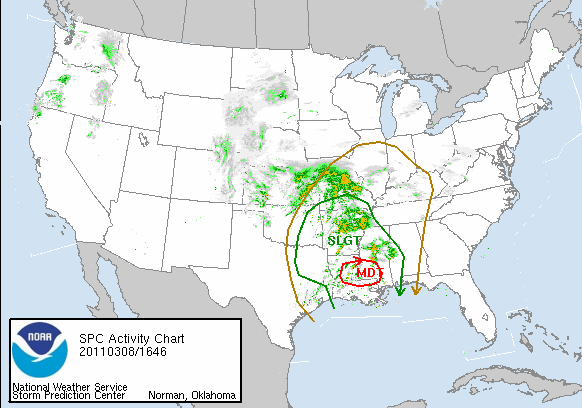
Tornado Risk for Louisiana... Again
Powerful thunderstorms, some capable of spawning tornadoes, will soon fire from Texas to Oklahoma then shift eastward into hard-hit Louisiana, the Florida Panhandle, Georgia, Tennessee and perhaps as far northeast as Ohio.
A multifaceted storm will target the middle of the nation today into Wednesday with snow and flooding rain in addition to the severe thunderstorms.
High winds, not associated with thunderstorms, were already causing damage and kicking up dust in California and neighboring states. This is a sign of a very dynamic system, much more so than the system that hit the south central states this past weekend.
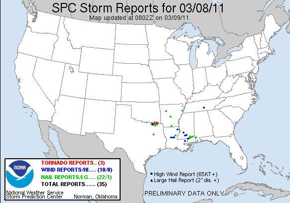
The setup later today into Wednesday will bring the threat of multiple tornadoes. A few of the tornadoes could even be strong.
Along with the threat of tornadoes is the likelihood of multiple incidents of large hail, damaging wind gusts, lightning strikes and flash flooding.
Today/Tonight
The area of concern for today into tonight lies from Dallas and Oklahoma City eastward to Springfield, Mo., Memphis, Tenn., and New Orleans.
Severe Weather Expert and WeatherData.com CEO Mike Smith is concerned that many of the storms will occur after dark Today.
"Some of the forecast tornadoes may be especially dangerous because people will not realize the storms are there until they are at the doorstep," Smith said.
The waves of storms will progress to the east, crossing the Mississippi River and igniting to the south toward the Gulf Coast.
South and west of the main center of the large storm system, strong winds will roar in the clear air over parts of New Mexico and western Texas. The winds will be strong enough to kick up dust, knock over high profile vehicle and down power lines. The winds could also spread wildfires.
Wednesday and Beyond
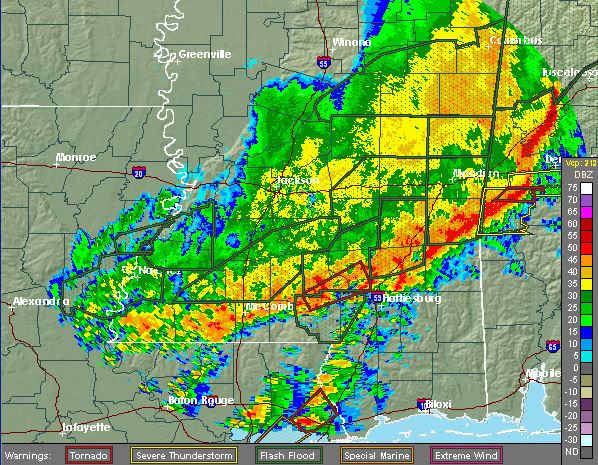
Tuesday night into Wednesday, the greatest risk of tornadoes will be in the Deep South from Louisiana to the Florida Panhandle, including much of Mississippi and Alabama. However, severe thunderstorms could occur as far north as the Ohio Valley.
Like most others, this storm system will eventually reach the Atlantic coast. For much of this area the major threat may be flash and urban flooding.
At least a few of the storms along the Atlantic Seaboard late in the week could be heavy and gusty. However, it is certainly possible that severe weather rolls along part of the I-95 corridor from Florida to Maine.
Meteorology of the Outbreak
A surge of warm, moist air will roll northward over the lower Mississippi Valley and into the southern Plains today. At the same time a sweep of dry air will attack from the west.
The combination of these two clashing air masses along with a developing surface storm and jet stream energy from above will allow severe thunderstorm to develop.
The shifting of winds with height will cause some of these thunderstorms to rotate. The rotation, in turn, can yield a tornado.
In more technical terms, the storm system will take on what meteorologists call a "negative tilt."
Intensifying systems of this nature have a long history of producing multiple tornadoes because of the way they are stacked through various layers of the atmosphere.
They are indicative of a cold air invasion high in the atmosphere, which allows the rising column of air within the thunderstorms to always be warmer than its surrounding environment.
[ Bericht 3% gewijzigd door #ANONIEM op 08-03-2011 17:00:38 ]
Powerful thunderstorms, some capable of spawning tornadoes, will soon fire from Texas to Oklahoma then shift eastward into hard-hit Louisiana, the Florida Panhandle, Georgia, Tennessee and perhaps as far northeast as Ohio.
A multifaceted storm will target the middle of the nation today into Wednesday with snow and flooding rain in addition to the severe thunderstorms.
High winds, not associated with thunderstorms, were already causing damage and kicking up dust in California and neighboring states. This is a sign of a very dynamic system, much more so than the system that hit the south central states this past weekend.
The setup later today into Wednesday will bring the threat of multiple tornadoes. A few of the tornadoes could even be strong.

Along with the threat of tornadoes is the likelihood of multiple incidents of large hail, damaging wind gusts, lightning strikes and flash flooding.
Today/Tonight
The area of concern for today into tonight lies from Dallas and Oklahoma City eastward to Springfield, Mo., Memphis, Tenn., and New Orleans.
Severe Weather Expert and WeatherData.com CEO Mike Smith is concerned that many of the storms will occur after dark Today.
"Some of the forecast tornadoes may be especially dangerous because people will not realize the storms are there until they are at the doorstep," Smith said.

The waves of storms will progress to the east, crossing the Mississippi River and igniting to the south toward the Gulf Coast.
South and west of the main center of the large storm system, strong winds will roar in the clear air over parts of New Mexico and western Texas. The winds will be strong enough to kick up dust, knock over high profile vehicle and down power lines. The winds could also spread wildfires.
Wednesday and Beyond
Tuesday night into Wednesday, the greatest risk of tornadoes will be in the Deep South from Louisiana to the Florida Panhandle, including much of Mississippi and Alabama. However, severe thunderstorms could occur as far north as the Ohio Valley.
Like most others, this storm system will eventually reach the Atlantic coast. For much of this area the major threat may be flash and urban flooding.
At least a few of the storms along the Atlantic Seaboard late in the week could be heavy and gusty. However, it is certainly possible that severe weather rolls along part of the I-95 corridor from Florida to Maine.
Meteorology of the Outbreak
A surge of warm, moist air will roll northward over the lower Mississippi Valley and into the southern Plains today. At the same time a sweep of dry air will attack from the west.
The combination of these two clashing air masses along with a developing surface storm and jet stream energy from above will allow severe thunderstorm to develop.
The shifting of winds with height will cause some of these thunderstorms to rotate. The rotation, in turn, can yield a tornado.
In more technical terms, the storm system will take on what meteorologists call a "negative tilt."
Intensifying systems of this nature have a long history of producing multiple tornadoes because of the way they are stacked through various layers of the atmosphere.
They are indicative of a cold air invasion high in the atmosphere, which allows the rising column of air within the thunderstorms to always be warmer than its surrounding environment.
[ Bericht 3% gewijzigd door #ANONIEM op 08-03-2011 17:00:38 ]
 Op
Op 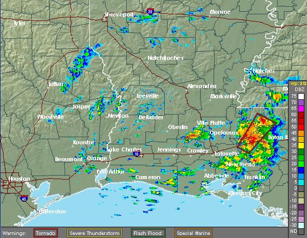

SPOILEROm spoilers te kunnen lezen moet je zijn ingelogd. Je moet je daarvoor eerst gratis Registreren. Ook kun je spoilers niet lezen als je een ban hebt.Wanneer je het wil volgen, klik op bovenstaand linkje.
Veel wateroverlast momenteel in de regio New Orleans
Stad Pensacola onder een tornado-warning momenteel
Hier is alles weer te volgen:
http://www.fox10tv.com/generic/video/LiveStream_FOX10
Hier is alles weer te volgen:
http://www.fox10tv.com/generic/video/LiveStream_FOX10
Meerdere tornado waarschuwingen, idd in de buurt van Pensacola
[ Bericht 1% gewijzigd door #ANONIEM op 09-03-2011 19:17:54 ]
[ Bericht 1% gewijzigd door #ANONIEM op 09-03-2011 19:17:54 ]
Weet niet of je mee kijkt Aloa, maar er is toch in de buurt van Mobile een krachtige tornado voorbij gekomen.. veel schade daar aan winkels/gebouwen/hoog spanningen etc etc
Edit: Stadje, Silverhill in Alabama getroffen door een tornado
[ Bericht 17% gewijzigd door Drassss op 09-03-2011 23:27:28 ]
Edit: Stadje, Silverhill in Alabama getroffen door een tornado


[ Bericht 17% gewijzigd door Drassss op 09-03-2011 23:27:28 ]
Er gebeurt veel momenteel zo te zien... tornadovideos.net zal ook wel live broadcasten.
's Avonds een man, overdags rustig an

Severe Outbreak Next Week May Affect a Quarter of US
After Florida was ransacked two days in a row with tornadoes, wind damage and battering hail, another outbreak of severe thunderstorms, including the risk of tornadoes, is set to unfold across a much larger area of the country early next week.
"This severe weather outbreak may affect a quarter of the U.S.," AccuWeather.com Senior Meteorologist Mike Smith stated.
It's a storm set to unload more snow across areas from the Rockies into the Upper Midwest this weekend into early next week that will also spark the widespread severe weather to its south.
"This is a very serious weather situation we have coming up and we have been issuing pinpoint severe weather warnings the past several days," said Bradley J. Mitchell, Chief Commercial Officer of AccuWeather Enterprise Solutions, "Notifying our SkyGuard clients of how this severe weather could affect their most important assets is a top priority for us."
While a few thunderstorms affecting areas from Missouri into Iowa and parts of the lower Midwest Saturday night into Sunday could become severe (mainly due to hail), the main outbreak of severe weather will not get under way until Sunday night and Monday.
On Sunday night, nasty thunderstorms will strike an area from northeastern Texas to northern Illinois and Indiana. Chicago and St. Louis are both included in the zone at risk for damaging thunderstorms.
The greatest threat for tornadoes will lie from northwestern Illinois to eastern Iowa and Missouri.
Threats with this outbreak Monday and Tuesday will include high winds, capable of downing trees and power lines and causing structural damage, large hail, and torrential rainfall, and even tornadoes with the strongest of thunderstorms.
Travel disruptions, by ground and air, are likely. Power outages will also be a problem for communities that are hit.
Areas from the Ohio, Tennessee, and Lower Mississippi valleys will be at risk by Monday as an extensive line of severe thunderstorms develops. Cities and towns from East Texas to western Pennsylvania are included.
The threat will then expand farther east across the Southeast and mid-Atlantic Monday night into Tuesday.
Metropolitan areas that could be affected Monday include Pittsburgh, Pa., Columbus, Ohio, Indianapolis and Evansville, Ind., Memphis, Tenn., Shreveport, La., and Houston, Texas.
Areas that will have to be monitored for possible impacts Monday night into Tuesday include Atlanta, Ga., Raleigh and Charlotte, N.C., Charleston, S.C. The thunderstorms could end up being disruptive to Tuesday's practice round for the Masters Golf Tournament in Augusta, Ga., if the line of thunderstorms progresses slower than expected.
It is still uncertain how far south the severe weather will extend into Florida Tuesday. Areas such as Tampa and Orlando that were in the heart of severe weather last Wednesday into Thursday will be closely monitored for potential impacts.

Op dit moment 10 thunderstorm warnings en 1 tornado warning. Ziet er spectaculair uit allemaal. Maar echt mooi georganiseerde / losstaande cellen heb ik nog niet gezien.
Weinig kans op tornado's vandaag 5% ongeveer.. Het weer is er net niet voor en zoals Them2 al aangeeft, weinig cellen maar meer 1 groot front.
| Forum Opties | |
|---|---|
| Forumhop: | |
| Hop naar: | |