WKN Weer, Klimaat en Natuurrampen
Lees alles over het onstuimige weer op onze planeet, volg orkanen en tornado's, zie hoe vulkanen uitbarsten en hoe Moeder Aarde beeft bij een aardbeving. Alles over de verwoestende kracht van onze planeet en tal van andere natuurverschijnselen.


Extreem weer in de V.S.
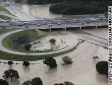
De Verenigde Staten kennen extreme weersituaties. Tornado's en orkanen eisen elk jaar tientallen levens. Plotseling opkomende onweersbuien zijn vooral in Florida gevaarlijk. In bergachtige gebieden en in woestijnen neemt de grond weinig water op en veranderen beekjes als gevolg van hevige regenval plotseling in kolkende watermassa's.
Tornado's
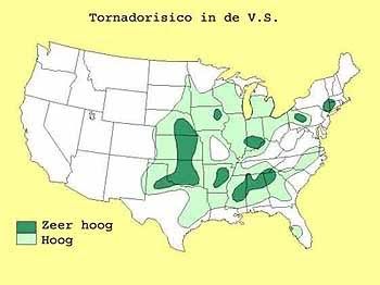
Tornado's ontstaan overal in de Verenigde Staten, maar het merendeel ten oosten van de Rocky Mountains in Texas, Kansas en Oklahoma, ook wel Tornado Alley genoemd. Jaarlijks razen ongeveer 1000 tornado's over de Verenigde Staten.
Er zijn twee tornadoseizoenen. De eerste is in april en mei en het tweede in november. In november beperken de tornado's zich tot Alabama, Mississippi en Louisiana.
Florida is berucht wegens het grote aantal onweersdagen. In Lightning Alley onweert het op meer dan 90 dagen per jaar.
vorige delen
Deel1: Weeralarm VS: Ongewoon zwaar tornadoseizoen
Deel2: Weeralarm V.S. #2 Extreem weer - Tornado touchdown!
enkele site's voor informatie
http://www.news9.com/
http://www.tornadovideos.net/
http://www.accuweather.com/news.asp
Amerikaanse weerinstituut National Weather Service
Voor orkanen is er: Hurricane Season 2010
Hagelstenen van een onweersbui bij Oklahoma City
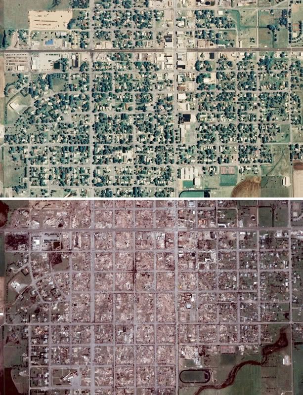
Foto Greensburg voor en na de Tornado Ramp
[ Bericht 5% gewijzigd door #ANONIEM op 17-05-2010 13:19:49 ]

De Verenigde Staten kennen extreme weersituaties. Tornado's en orkanen eisen elk jaar tientallen levens. Plotseling opkomende onweersbuien zijn vooral in Florida gevaarlijk. In bergachtige gebieden en in woestijnen neemt de grond weinig water op en veranderen beekjes als gevolg van hevige regenval plotseling in kolkende watermassa's.

Tornado's
Tornado's ontstaan overal in de Verenigde Staten, maar het merendeel ten oosten van de Rocky Mountains in Texas, Kansas en Oklahoma, ook wel Tornado Alley genoemd. Jaarlijks razen ongeveer 1000 tornado's over de Verenigde Staten.
Er zijn twee tornadoseizoenen. De eerste is in april en mei en het tweede in november. In november beperken de tornado's zich tot Alabama, Mississippi en Louisiana.
Florida is berucht wegens het grote aantal onweersdagen. In Lightning Alley onweert het op meer dan 90 dagen per jaar.
Nieuwsberichten, foto's, filmpjes over tornado's, onweer, overstromingen etc etc kun je hier in dit topic kwijt.quote:Tornado Parkersburg tweede EF5 van de eeuw
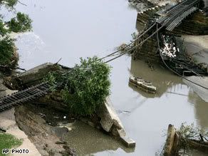
De tornado die zondagmiddag om 18 uur door Parkersburg in de stad Iowa trok is gedefinieerd als een EF-5 tornado. Daarmee is sprake van de tweede EF5-tornado van deze eeuw. De laatste keer dat dit gebeurde was op 4 mei 2007 in Greensburg (Kansas).
De tornado in Parkersburg was de zwaarste tornado voor Iowa sinds 1976. De tornado trok met windsnelheden van 328 kilometer per uur door het dorp en had een breedte van 800 meter. Daarbij vielen volgens de officiële statistiek van de Nationale Weerdienst 6 doden. 50 mensen raakten gewond.
vwk
vorige delen
Deel1: Weeralarm VS: Ongewoon zwaar tornadoseizoen
Deel2: Weeralarm V.S. #2 Extreem weer - Tornado touchdown!
enkele site's voor informatie
http://www.news9.com/
http://www.tornadovideos.net/
http://www.accuweather.com/news.asp
Amerikaanse weerinstituut National Weather Service
Voor orkanen is er: Hurricane Season 2010
Hagelstenen van een onweersbui bij Oklahoma City
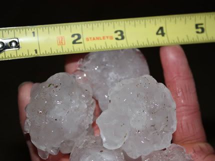
Foto Greensburg voor en na de Tornado Ramp
[ Bericht 5% gewijzigd door #ANONIEM op 17-05-2010 13:19:49 ]
http://www.news9.com/
Misschien deze link nog in de OP zetten. Newszender die er altijd bij is wanneer er tornado's in Oklahoma zijn. Heli's die naast tornado's vliegen etc
Misschien deze link nog in de OP zetten. Newszender die er altijd bij is wanneer er tornado's in Oklahoma zijn. Heli's die naast tornado's vliegen etc

Ik heb hem er tussen gezetquote:Op maandag 17 mei 2010 13:14 schreef Drassss het volgende:
http://www.news9.com/
Misschien deze link nog in de OP zetten. Newszender die er altijd bij is wanneer er tornado's in Oklahoma zijn. Heli's die naast tornado's vliegen etc

Ging snel ineens. Topic geopend in 2008.quote:Op maandag 17 mei 2010 14:29 schreef Frutsel het volgende:
[..]
Mooie OP
Deeltje 3 alweer... deel 2 liep ineens een stuk sneller
http://www.news9.com/Global/category.asp?C=116601&clipId=4793811&autostart=true
Nog even wat filmpjes van het hagelgeweld. Sorry voor het laffe Amerikaanse gezeik eromheen...
Nog even wat filmpjes van het hagelgeweld. Sorry voor het laffe Amerikaanse gezeik eromheen...
Nog wat beelden van de hagel:
1. http://www.zie.nl/video/o(...)elstorm/m1cziiafijuj
2.
[ Bericht 0% gewijzigd door i2Them2 op 18-05-2010 16:02:44 ]
1. http://www.zie.nl/video/o(...)elstorm/m1cziiafijuj
2.

[ Bericht 0% gewijzigd door i2Them2 op 18-05-2010 16:02:44 ]
The fuck, je auto zou maar buiten staanquote:Op dinsdag 18 mei 2010 14:53 schreef i2Them2 het volgende:
Nog wat beelden van de hagel:
http://www.zie.nl/video/o(...)elstorm/m1cziiafijuj
Op woensdag 21 maart 2012 19:42 schreef Drassss het volgende:
Ben ik de enige die steeds Sideboobie leest ipv van Sideshowbobbie
Ben ik de enige die steeds Sideboobie leest ipv van Sideshowbobbie
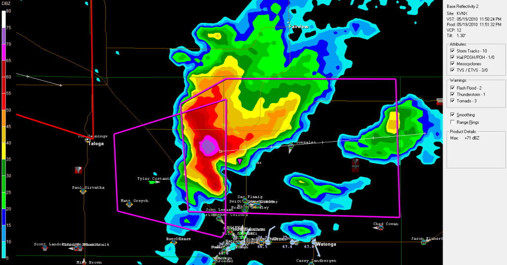
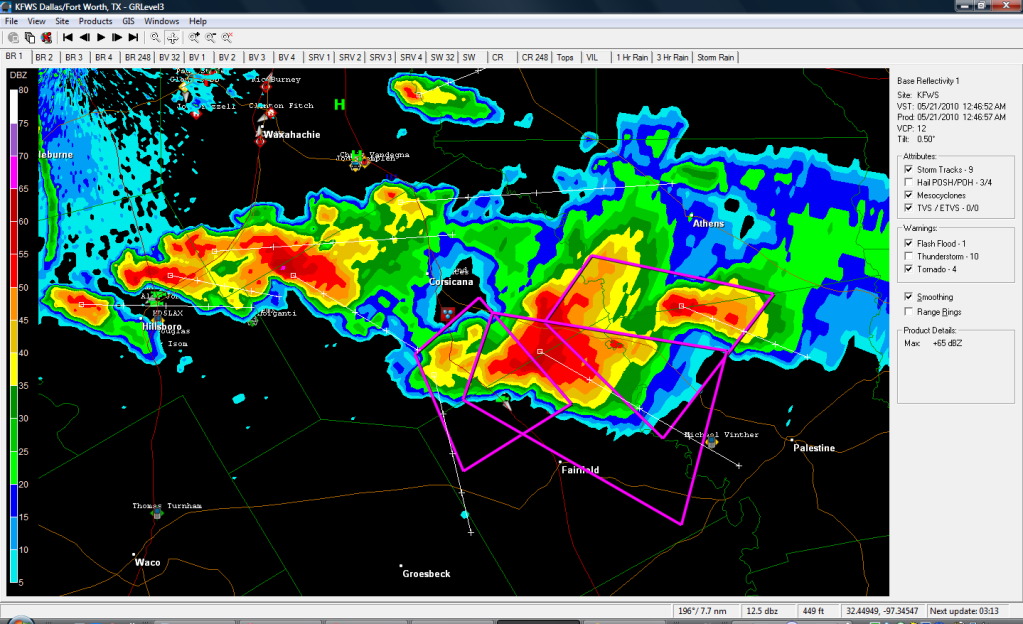
Tornado gebied gaat nu recht op het plaatsje Taloga af. Daar achter is nog een cel actief en die gaat op Lipscomb af.
Lipscomb krijgt nu een tornado warning. 2 cellen om het dorpje heen.
Andere cel ( 1,5 inch hagel ) is nu noord van Watonga en oostwaards aan het gaan
Andere cel ( 1,5 inch hagel ) is nu noord van Watonga en oostwaards aan het gaan
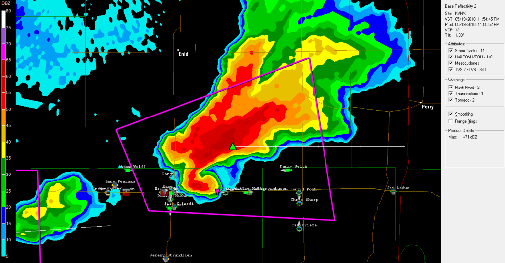
Zwaar deel met hagel van 2 inches gaat recht op Perry af. Hopelijk blijft het bij dit en gaat het geen tornado worden. Het is daar nu 6u sochtends....
Klopt, dat duurt nog wel eventjes, maar alles schuift langzaam richting Tulsa.
Edit: Alhoewel het iets noord van Tulsa lijkt te trekken.
Edit: Alhoewel het iets noord van Tulsa lijkt te trekken.

Leuk lijntje! Vooral op de plek waar de lijn zich lijkt te splitsen kans op een tornado of andere hevige windverschijnselen. Dit geldt ook voor het zuidelijkste punt.
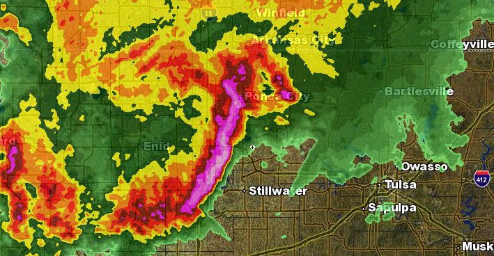
OKLAHOMA CITY – Severe storms are rolling through northern Oklahoma this morning. and more severe weather is expected this afternoon.
The storms have been concentrated in north central Oklahoma this morning moving through the Enid and Ponca City areas. A severe thunderstorm watch is in effect for north central and northwestern Oklahoma until 10 a.m.
A strong system may produce severe storms Wednesday afternoon into Wednesday evening. The storms will likely begin to develop after 3 p.m.
The biggest threat with the storms will be large hail, damaging wind and tornadoes.
AddThis Social Bookmark Button
Weer heel wat gebeurd gisteravond zeg! En vanavond/vannacht high kans op severe weather...
Check dit dan. Hagelbui afgelopen zondag, bizar:
Check dit dan. Hagelbui afgelopen zondag, bizar:


's Avonds een man, overdags rustig an

Filmpje stond er al in. Dat zwembadquote:Op woensdag 19 mei 2010 19:04 schreef Burnie88 het volgende:
Weer heel wat gebeurd gisteravond zeg! En vanavond/vannacht high kans op severe weather...
Check dit dan. Hagelbui afgelopen zondag, bizar:
Tussen 00.00 en 03.00 onze tijd zal in OKC moderate risk van severe weather zijn. Kans op tornado's etc. Kan weer een zware dag voor Oklahoma worden..
OKLAHOMA CITY – Severe storms rolled through northern Oklahoma Wednesday morning and more severe weather is expected through this afternoon and into the evening.
The storms were concentrated in north central Oklahoma this morning moving through the Enid and Ponca City areas. A severe thunderstorm watch was in effect for north central and northwestern Oklahoma until 10 a.m.
A strong system may produce severe storms Wednesday afternoon into Wednesday evening. The storms will likely begin to develop after 3 p.m.
The biggest threat with the storms will be large hail, damaging wind and tornadoes.
[ Bericht 35% gewijzigd door Drassss op 19-05-2010 21:11:10 ]
Ze hebben nu al een county of 20 een watch gegeven in Oklahoma. Gaat echt een zware dag worden. Toch maar eens allemaal volgenquote:Op woensdag 19 mei 2010 22:00 schreef aloa het volgende:
Pittsburg krijgt het zo zwaar te verduren.
Er is nu wel een Tornado watch uitgegeven.
Echte uitbraak gaat over 40 min beginnen. Weermensen in Oklahoma verwachten toch wel een afschuwelijke dag... misschien nog erger dan vorige week maandag.
Correct, ziet er erg slecht uit.quote:Op woensdag 19 mei 2010 22:26 schreef Frutsel het volgende:
Oklahoma City ligt midden in het potentieel gevaarlijkste gebied?
http://www.news9.com/Global/category.asp?C=184600
Kan je live weather news zender volgen met Gary, en freaks die naast tornado's gaan vliegen/rijden.
Kan je live weather news zender volgen met Gary, en freaks die naast tornado's gaan vliegen/rijden.
Enid kan weer een hit krijgen van een cell die net op het scherm is gekomen.
Voor de warning in het westen van Oklahoma op dit moment.
Voor de warning in het westen van Oklahoma op dit moment.
Geen probleem Burnie.
Ja gaat echt al los en pas over 15 min zou het echt losgaan volgens weatherchannel.
Nu al 4 cellen actief met 2 warnings.
Edit: Vorig jaar vaak genoeg achter men televisie gezeten toen ik daar was
Ja gaat echt al los en pas over 15 min zou het echt losgaan volgens weatherchannel.
Nu al 4 cellen actief met 2 warnings.
Edit: Vorig jaar vaak genoeg achter men televisie gezeten toen ik daar was
De westelijk cel schijnt al even een tornado aan de grond te hebben. In ieder geval 10 minuten geleden nog wel. Ook al 2 inch hail trouwens.
Maar ben benieuwd hoe lang die cel het nog uit houdt. Inflow lijkt afgesneden te worden door een ander buitje.
Maar ben benieuwd hoe lang die cel het nog uit houdt. Inflow lijkt afgesneden te worden door een ander buitje.
Geweldige beelden vanuit die helikopter. Ik denk dat het voorlopig nog even wachten zal zijn totdat er wat gaat gebeuren. Deze cells zijn mooi, maar geen haak en rotatie. Wel mooie wallclouds 
's Avonds een man, overdags rustig an
Het lijkt er trouwens op dat de cells wat afzwakken. Helaas, morgenochtend weer werken, dus ik hou het voor gezien. Veel plezier vanavond en post wat mooie beelden/footages s.v.p.!
's Avonds een man, overdags rustig an


Die er net achter, west?quote:Op woensdag 19 mei 2010 23:52 schreef i2Them2 het volgende:
De grotere supercell iets naar het westen begint ook zijn krachten weer terug te krijgen. Ben benieuwd of die nog wat op de grond zet.
Tevens die cell noord van Lawton zit zal zo wat laten zien. Ook beginnende cellen oost van Oklahoma City.
Zal flink wat hagel in zitten waarschijnlijk. Verder een mooie cel.
Nadeel is wel dat er alweer buien ontstaan in het pad van de cel. Hierdoor zal de inflow waarschijnlijk weer wat afgesneden worden.
Nadeel is wel dat er alweer buien ontstaan in het pad van de cel. Hierdoor zal de inflow waarschijnlijk weer wat afgesneden worden.
Jep hij kan zomaar gaan afzwakken.
Let goed op de cell bij Lawton, dat kan echt een klapper gaan worden.
Let goed op de cell bij Lawton, dat kan echt een klapper gaan worden.
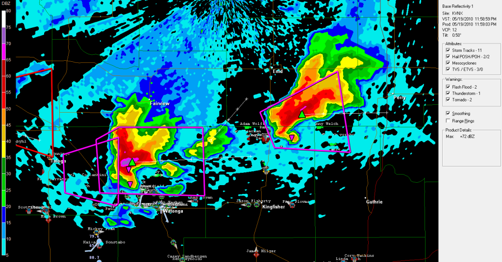
Ja die is prachtig. Daar kwam net de 1ste tornado uit.quote:Op donderdag 20 mei 2010 00:04 schreef i2Them2 het volgende:
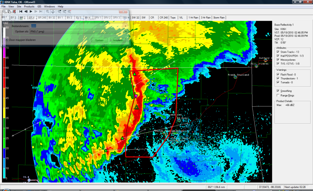
Beeld van de andere cel. Zit een leuke haak aan.
[ afbeelding ]
Die cell idd in de gaten houden.quote:Op donderdag 20 mei 2010 00:04 schreef Drassss het volgende:
Jep hij kan zomaar gaan afzwakken.
Let goed op de cell bij Lawton, dat kan echt een klapper gaan worden.
Beeld van de beide noordelijke cellen dan maar.

Ja zit nu een thunderstorm warning op. Gelukkig woont in dat gebied echt niemand.quote:Op donderdag 20 mei 2010 00:14 schreef i2Them2 het volgende:
Nu ook een cel verder in het oosten ontstaan. Gaat zeer hard. Lijkt al een haak aan te zitten.

Ziekelijk nu. Overal zijn cellen, Stillwater krijgt nu een direct hit. Guthrie van een andere cell, zuid van OKC ook een aantal cellen. Niet te geloven dit.


quote:Multiple Tornadoes Touch Down Across Oklahoma
OKLAHOMA CITY -- At least six tornadoes touched down across the state Wednesday.
The National Weather Service reported tornadoes in mostly sparsely populated areas of central and northern Oklahoma, although warnings extended as far south and east as the Oklahoma City and Tulsa metropolitan areas.
The National Weather Service reported tornadoes near Leedey in Dewey County, near Douglas in Garfield County, near Marshall in Logan County and near Loyal, Hennessey in Kingfisher County, and near Wynnewood in Garvin County.
Several areas reported large hail. One report was up to baseball size.
A very large tornado touched down around 4:40 and barely missed Hennessey. It was on the ground for at least six or seven minutes. The twister brushed closely to the west and northwest side of the city, but there are no reports of major damage. After it disappeared, another, smaller rope tornado briefly touched down from the same cloud.
SkyNEWS 9 HD also reported a tornado just south of Marshall.
The Kingfisher Fire Department reported power lines down in the area, just 2 miles west of Loyal. They also said an overturned semi was struck by a tornado about 2 miles south of Dover. Emergency management director Steve Loftis said the driver was taken to a nearby hospital with injuries that weren't considered life-threatening.
Power lines are down inside the city of Loyal. Damage was reported to one unoccupied trailer in a trailer park on the west side of Loyal. Residents have also said large trees have been uprooted in the area.
Residents reported major hail damage in Canton with broken windows and destroyed wheat fields.
Severe storms rolled through northern Oklahoma Wednesday morning. The storms were concentrated in north central Oklahoma this morning moving through the Enid and Ponca City areas. A severe thunderstorm watch was in effect for north central and northwestern Oklahoma until 10 a.m.
Authorities said at least one person was hurt as severe weather raked across northern Oklahoma Wednesday morning. Oklahoma Department of Emergency Management spokeswoman Michelann Ooten said a truck driver was injured when straight-line winds blew over a semi on Interstate 35 near Tonkawa. The driver was taken to a local hospital and his condition was not known, Ooten said. Two other semitrailers also were blown over on the interstate, she said.
The National Weather Service said at least three tornadoes may have touched down overnight Wednesday in far northwestern Oklahoma, including one near Arnett and two near Guymon.

Heb je daar nog (radar)beelden van?quote:Op donderdag 20 mei 2010 01:23 schreef Drassss het volgende:
Ziekelijk nu. Overal zijn cellen, Stillwater krijgt nu een direct hit. Guthrie van een andere cell, zuid van OKC ook een aantal cellen. Niet te geloven dit.
Spijt me die heb ik niet meer gemaakt. Cellen bij Stillwater en de west cell werden opeens 2x zo groot. Kijken of ik wat reports kan vinden van ze.quote:
Mag ik stellen dat het gisteren was tegenviel uiteindelijk? Wel mooie beelden trouwens! Bedankt voor de footage heren, leuk om terug te lezen
's Avonds een man, overdags rustig an
Qua tornado's viel het tegen, maar qua stormen die overal en nergens waren was het eigenlijk best ziek. Veelquote:Op donderdag 20 mei 2010 23:33 schreef Burnie88 het volgende:
Mag ik stellen dat het gisteren was tegenviel uiteindelijk? Wel mooie beelden trouwens! Bedankt voor de footage heren, leuk om terug te lezen
grote steden werden getroffen. Ik hoop nog wat amerikanen te spreken, misschien weten ze nog iets meer.
http://www.news9.com/Global/category.asp?C=116601&clipId=4801312&topVideoCatNo=118433&autoStart=true
Stillwater kreeg echt een direct hit, ook een aantal steden zuid van OKC ( Moore/Norman ).
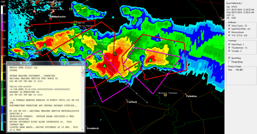
Nu iets van een haak. Verder wordt er gesproken over een funnelcloud. Naast deze tornado warning staat er ook nog een warning uit in Missouri. Die cel is wel wat minder spectaculair.
quote:Severe storms to rattle Michigan to West Texas
.Severe storms will ignite over a large part of the Plains by later today and tonight, threatening lives and property. The strongest storms could spawn tornadoes.
From northern Ontario, Canada, and northern Michigan to West Texas, some severe storms will erupt along the collision of steamy air surging from the Gulf of Mexico and less humid air farther west. A new storm arriving in the High Plains by tonight will trigger intense storms that rattle portions of the Plains.
Places at risk for severe storms include: Green Bay, Wis., Minneapolis, Minn., Omaha, Neb., to Goodland and Liberal, Kan., Roswell, N.M., and Lubbock, Texas.
Severe Storm Threats Today and Tonight
Hail larger than quarters and even golf balls, damaging wind gusts over 60 mph, and a few tornadoes will threaten to cause damage. Trees and power lines will be downed, littering some communities, while structural damage to homes and businesses will be a possibility.
Flash flooding could force some roads to be closed where the heaviest downpours are unleashed.
Along a cold front that sparked severe storms in the Dakotas on Saturday, some severe storms will develop during the afternoon over southern Minnesota, northern Iowa, western Wisconsin and western portions of the Upper Peninsula of Michigan.
These storms will shift farther east and become more sparse by the overnight hours.
Farther to the south, a few isolated, severe storms will erupt from West Texas to southwestern Iowa, during the peak warm afternoon hours.
Storms in the central and southern Plains, especially in eastern Colorado, western Kansas, the Oklahoma Panhandle and northern portions of the Texas Panhandle, will become more widespread and violent into the late evening and overnight hours. This will happen as a storm system over the Four Corners region advances northeastward toward the High Plains.
The most violent storms will shift northward into Nebraska and southern South Dakota by the early morning hours.
Severe Storms to Ignite Over Length of Plains Again Monday
Potentially damaging severe storms will fire from central Minnesota to West Texas again on Monday along the cold front of a storm arriving in the northern Plains.
Storms will be capable of producing more tornadoes, large hail and damaging wind gusts.


Dat 2e filmpje is inderdaad geweldig. Gewoon een EF4 terwijl er geen high risk was o.i.d.
's Avonds een man, overdags rustig an
Inmiddels gaan we weer los. Al 3 weather watches, een paar supercells aan het ontwikkelen. Moderate Risk.
's Avonds een man, overdags rustig an
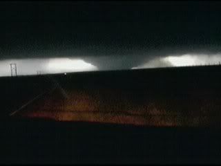
Live beelden van een tornado
http://www.severestudios.com/cgi-bin/player-full.pl?username=john.wetter&uid=84
http://www.severestudios.com/cgi-bin/player-full.pl?username=john.wetter&uid=84


Het was gisteravond/vannacht weer een chaos in de VS, nu vooral in het noorden. Al 46 tornado's bevestigd waaronder een aantal fatale... Ook zijn er een aantal dorpen heftig beschadigd wat toch wel duidt op de wat grotere tornado's. Beelden zullen vast en zeker snel beschikbaar zijn.
's Avonds een man, overdags rustig an
Hmm ik zal eens wat rondkijken op wat sites. Misschien vind ik wat.quote:Op zondag 6 juni 2010 10:25 schreef Burnie88 het volgende:
Het was gisteravond/vannacht weer een chaos in de VS, nu vooral in het noorden. Al 46 tornado's bevestigd waaronder een aantal fatale... Ook zijn er een aantal dorpen heftig beschadigd wat toch wel duidt op de wat grotere tornado's. Beelden zullen vast en zeker snel beschikbaar zijn.