WKN Weer, Klimaat en Natuurrampen
Lees alles over het onstuimige weer op onze planeet, volg orkanen en tornado's, zie hoe vulkanen uitbarsten en hoe Moeder Aarde beeft bij een aardbeving. Alles over de verwoestende kracht van onze planeet en tal van andere natuurverschijnselen.


Jup, pwetty lights en warm water in het smeltwaterriviertje. Nog geen bevingen, die lava stroomt er gewoon rustig uit. Dit is het dag rapport van vandaag:quote:Op maandag 3 mei 2010 00:39 schreef mouzzer het volgende:
[..]
Dan zou ik nu even kijken
http://eldgos.mila.is/eyjafjallajokull-fra-fimmvorduhalsi/
Lol, hij snottert hete lava en de metingen komen waarschijnlijk van ijs-lava interactie of omstandigheden op de eruptiesite, klinkt logisch. Wat me opvalt is dat de patronen in de gletsjer wat veranderen. Ik weet niet wat dat betekent maar het lijkt me dat er dan dingen veranderen, of dat goed of slecht is weet ik niet....quote:Eruption in Eyjafjallajökull - Status Report: 21:00 GMT, 02 May 2010
Icelandic Meteorological Office and Institute of Earth Sciences, University of Iceland
Compiled by: MJR / MTG / FS / BO / SSJ / SH
Based on: IMO seismic monitoring; IES-IMO GPS monitoring; IMO hydrological data; web cameras of the eruption site from Vodafone, Mila, and Múlakot; IMO weather radar measurements; information from scientists at Gígjökull. [No scientific overflight today.]
Eruption plume:
Height (a.s.l.): Estimated from web-camera views and observers on the ground at an elevation of 4–5.4 km (13–18,000 ft). Clouds of ash at lower elevations observed drifting south-east of the eruption site. No verifiable detections from the weather radar at Keflavík Airport.
Heading: South-east from the eruption site. Plume track visible at least 200 km from the eruption site on MODIS (12:35 GMT) and EUMETSAT (17:15 GMT) satellite imagery.
Colour: Dark grey (ash) clouds observed over the eruptive site. White (steam) plumes rising from Gígjökull, north of the eruption site.
Tephra fallout: Moderate ash-fall reported in the village of Vík (12:00 GMT), located 40 km south-east of Eyjafjallajökull.
Lightning: No detections today over the eruption site (18:00 GMT).
Noises: Booming sounds heard during the night and throughout the day up to 40 km south-east of the eruption site.
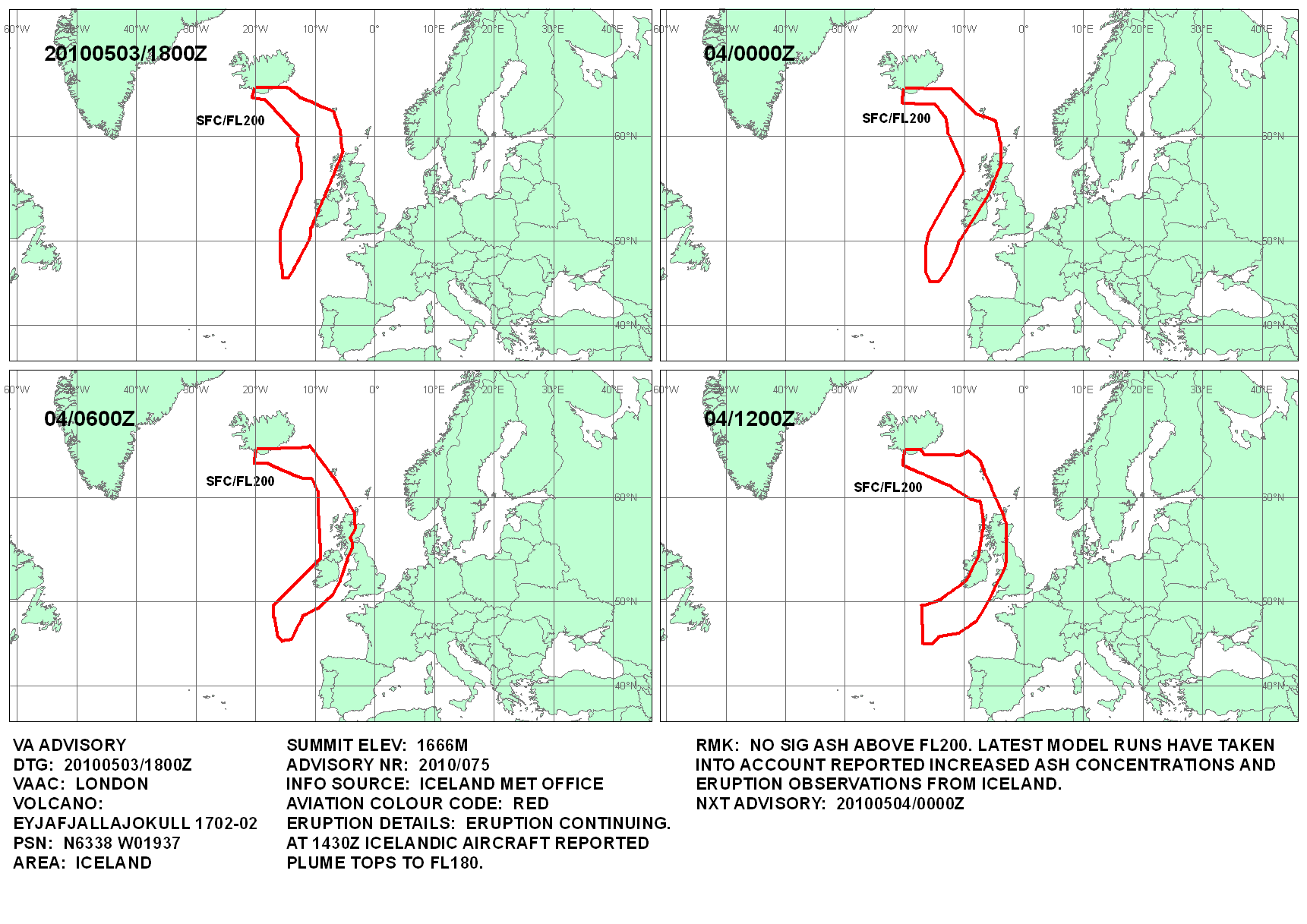
Additional note: Plumes of white steam extend partway down Gígjökull. Lava appears to have advanced further down Gígjökull overnight. Aerial observations at 18:25 GMT confirmed a dense cloud of ash between 3–3.3 km a.s.l. (10,000–11,000 ft) at 60° N, 16° W (~470 km south-east of Iceland). London VAAC have been informed about this siting.
Meltwater:
Before 16:00 GMT, discharge levels at the old Markarfljóts bridge, ~18 km downstream from Gígjökull, were noticeably lower than yesterday's levels. Between 16:00–17:00 GMT, a meltwater pulse was detected at the bridge; the flood was comparable in size to earlier floods on 30 April. At 19:40 GMT, web-camera images of Gígjökull showed plumes of steam rising from the glacier edge. Additionally, steam is rising from the delta that occupies the lake basin, suggesting
the discharge of near-boiling meltwater.
Conditions at eruption site:
Explosive activity has increased somewhat over the last 2–3 days; mass flux in the plume is estimated at 10–20 tonnes/s. A scoria cone continues to form at the eruption site. Lava is propagating down Gígjökull and most of its energy is being used to melt ice. As lava advances down-glacier, the size of the ice canyon increases. Large plumes of steam are produced where lava is in contact with ice and meltwater.
Seismic tremor:
During the last 30 hours, tremor levels have intensified. This intensification could be due to lava-ice interactions within Gígjökull, or conditions at the eruption site.
Earthquakes:
No locatable seismicity detected beneath Eyjafjallajökull.
GPS deformation:
Horizontal displacement towards the centre of the volcano, in addition to vertical subsidence. In the last couple of days increased subsidence has been observed at stations closest to the eruptive crater. These observations are consistent with deflation of a magma reservoir beneath Eyjafjallajökull, although the deformation pattern has changed somewhat.
Magma flow:
See overall assessment.
Other remarks:
No measurable geophysical changes within the Katla volcano.
Overall assessment:
The eruption is mixed, with the lava-producing phase being larger than the explosive phase. During the last 2–3 days, the plume has been darker and wider than in the preceding week. Tephra fall-out in the vicinity of Eyjafjallajökull has increased. From the location of the steam plume over Gígjökull, lava has advanced over 3 km north of the eruption. Steam plumes over the glacier edge from 19:40 GMT suggest that lava may have advanced even further. A rough order-of-magnitude estimate of lava volume can be obtained from the dimensions of the ice canyon. This estimate gives a lava production rate of-the-order 20 m3 /s (i.e. 50 tonnes/s). The explosive phase may be 10–20 tonnes/s. The explosive phase has increased somewhat in intensity during the last few days. Presently, there are no measurable indications that the eruption is about to end.
Bron: http://www2.norvol.hi.is/page/ies_Eyjafjallajokull_eruption
be nice or go away
Het zijn vijf bevingen! Oei! Zie hier close-up van de kaart: http://en.vedur.is/earthq(...)uakes/myrdalsjokull/
Allemaal tegelijk rond 5 uur. Er wordt nog nergens over gesproken en er zijn te veel wolken om op de cams te kijken.quote:Op maandag 3 mei 2010 10:27 schreef Mountainwatcher het volgende:
Het zijn vijf bevingen! Oei! Zie hier close-up van de kaart: http://en.vedur.is/earthq(...)uakes/myrdalsjokull/
Op de grafiekjes nog immer veel activiteit, ik kan er de bevingen niet op terugvinden, geen idee wat en hoe, bij het dagrapport vanavond zullen we het wel lezen denk ik.
be nice or go away

Even een jaar oude kick
Mount St.Helens - Mei 1980 - Toen en Nu
KABOOEEEMM zei de vulkaan... één van de roemruchtigste uitbarstingen van de 20e eeuw
30 jaar geleden deze maand
Mount St.Helens - Mei 1980 - Toen en Nu
KABOOEEEMM zei de vulkaan... één van de roemruchtigste uitbarstingen van de 20e eeuw
30 jaar geleden deze maand
Nee, dit is nog niet eng, dan moet er meer gebeuren, de eerste dag van de uitbarsting was er bijna niets anders te zien dan stipjes, ik gok op een stuk gletjer dat is ingestort door zijn eigen gewicht boven de gaten die de lava hebben gemaakt, daarom wil ik graag beeld zien op de cams maar het is te bewolkt.quote:Op maandag 3 mei 2010 11:23 schreef Mountainwatcher het volgende:
Is het dan een clusterbeving? Die gaan toch meestal vooraf aan een nieuwe uitbarsting?
be nice or go away
Weet jij wat er gebeurt als er een stuk gletsjer gaat rommelen? Ik ook niet.quote:Op maandag 3 mei 2010 12:32 schreef Isdatzo het volgende:
Met een diepte van rond de 18km (4) en 2km (2) lijkt dat niet bepaald 't geval.
be nice or go away

Ik welquote:Op maandag 3 mei 2010 12:46 schreef kahaarin het volgende:
[..]
Weet jij wat er gebeurt als er een stuk gletsjer gaat rommelen? Ik ook niet.
Moet sowieso een héél groot stuk gletsjer zijn om boven de 1 op de richterschaal uit te komen. En dan niet op een diepte van 18km natuurlijk.
Huilen dan.
Lol, echt waar?!quote:Op maandag 3 mei 2010 12:50 schreef Isdatzo het volgende:
[..]
Ik wel.
Moet sowieso een héél groot stuk gletsjer zijn om boven de 1 op de richterschaal uit te komen. En dan niet op een diepte van 18km natuurlijk.
be nice or go away

Neuh, geen reden tot paniek. Misschien wel een reden om nog maar eens een optie op een vliegticket te nemen misschienquote:
[..]
Lol, echt waar?!
Huilen dan.
Oeh, dan wel foto's maken en hier posten!quote:Op maandag 3 mei 2010 14:59 schreef Isdatzo het volgende:
[..]
Neuh, geen reden tot paniek. Misschien wel een reden om nog maar eens een optie op een vliegticket te nemen misschien.
quote:Increased Explosive Activity in Iceland Volcano
The explosive activity in the volcano in Eyjafjallajökull glacier seems to be increasing as the volcanic cloud has been larger and darker in color in the past few days than what it was the week prior, according to a new report from the Icelandic Meteorological Office.
The eruption in Eyjafjallajökull. Photo by Páll Stefánsson.
The same applies to the eruption activity. The report says this increase might be caused because of the interplay between ice and lava in the Gígjökull glacial tongue or changes to the volcanic channel. There is nothing that indicates that the eruption is ending, visir.is reports.
The water flow in the Markarfljót river, which originates in Gígjökull, increased temporarily yesterday and reached the same level as during the flooding of April 30.
Around 7:30 last night webcams showed a steam cloud at the edge of the glacial tongue, which indicates that the ice which has melted has heated up.
A dust storm raged in the area where the most ash had fallen below the Eyjafjöll mountain range yesterday afternoon, Morgunbladid reports.
A dense volcanic cloud filled with ash emerged from the clouds overhanging the mountains and blew across the farmstead of Raufarfell, while old ash was carried with the northwestern wind from the slopes of the mountains, blocking the view.
Close to midnight last night the lava flow from the volcano appeared to have reached the end of Gígjökull. Eyewitnesses told police in Hvolsvöllur that the lava is flowing by the edge of the glacial tongue. A red glow was seen at Gígjökull.

be nice or go away

Yup, had ook begrepen dat de lava ondertussen het einde van de gletsjer bereikt had. Da's dus een mooie bonus als ik ga  .
.
* Isdatzo weer eens met reiscompagnon gaat overleggen.
* Isdatzo weer eens met reiscompagnon gaat overleggen.
Huilen dan.
Ja, dat las ik ook, ik hoop dat je reiscompagnon er ook zin in heeft.quote:Op maandag 3 mei 2010 17:00 schreef Isdatzo het volgende:
Yup, had ook begrepen dat de lava ondertussen het einde van de gletsjer bereikt had. Da's dus een mooie bonus als ik ga
* Isdatzo weer eens met reiscompagnon gaat overleggen.
oh ja, bron voor het artikel: http://icelandreview.com/icelandreview/daily_news/?cat_id=16539&ew_0_a_id=361709
be nice or go away
Maar die lava stroomt nu dus langzaam dat dal in als het goed begrijp ? Vet, kun je hem straks helemaal volgen tot aan de zee
Ja, jammer genoeg is het steeds bewolkt, als het helder was dan was het een veel spectaculairder gezicht geweest denk ik.quote:Op maandag 3 mei 2010 17:05 schreef Ermanon het volgende:
Maar die lava stroomt nu dus langzaam dat dal in als het goed begrijp ? Vet, kun je hem straks helemaal volgen tot aan de zee
Tot aan zee trouwens? Je weet dat de gletsjer 10km van de zee af is?

be nice or go away

Yup, zag 't op twitter voorbijkomen...quote:
Waarschijnlijk het luchtruim van Ierland weer dicht.
quote:@drivetimerte: Breaking News: IAA may be forced to restrict flights over Irish airspace because of volcanic ash #ashtag on air now @RTERadio1
quote:Vliegvelden Ierland morgen gesloten
Vanaf morgenvroeg is het vliegverkeer
van en naar Ierland niet mogelijk.De
Ierse luchtvaartautoriteiten hebben
besloten geen vluchten toe te laten
vanwege vulkaanas dat vanuit IJsland
over Ierland waait.Er staat morgen een
noordelijke wind.
Om 8.00 uur Nederlandse tijd wordt het
vliegverkeer stilgelegd.Vooralsnog
geldt het vliegverbod tot 14.00 uur
morgenmiddag,dan wordt de situatie
opnieuw bekeken.
Vluchten die op grote hoogte over
Ierland heengaan vallen niet onder het
vliegverbod.
Never in the entire history of calming down did anyone ever calm down after being told to calm down.
Yup, dagrapport heeft het ook over de verhoogde activiteit.quote:
Hmm, ik krijg een beetje een snelkookpan idee, alle ingredienten zijn er, stoom, een hittebron en een vat. (de berg zelf)quote:Eruption in Eyjafjallajökull - Status Report: 16:00 GMT, 03 May 2010
Icelandic Meteorological Office and Institute of Earth Sciences, University of Iceland
Compiled by: Sigurlaug Hjaltadóttir, Freysteinn Sigmundsson, Björn Oddsson, Sigrún Hreinsdóttir, Þórdís Högnadóttir.
Based on: IMO seismic monitoring; IES-IMO GPS monitoring; IMO hydrological data; web cameras of the eruption site from Vodafone; IMO weather radar measurements, MODIS satellit image; information from scientists at Gígjökull, information from the Icelandic Coast Guard flight.
Eruption plume:
Height (a.s.l.): Largest plumes observed at 5-5,5 km height (17-18,000 ft) estimated from the Icelandic Coast Guard (ICG) flight at 14:30. The plume has also been observed on IMO's weather radar at 4.0-5.2 km height between 13:00 and 15:00 GMT. The plume rises higher after large explosions.
Heading: East-south-east to south-east from the eruption site. Plume track clearly visible at least 200 km from the eruption site and probably another 200 further to the SE on MODIS (11:20 GMT) satellite imagery.
Colour: Observation from ICG-flight: Dark grey (ash) clouds observed over the eruptive site. White (steam) plumes rising from Gígjökull otulet glacier, north of the eruption site (similar as yesterday).
Tephra fallout: Moderate ash-fall reported in Álftaver, 65-70 km east-south-east of Eyjafjallajökull (07:00-10:00 GMT. An ash cloud also observed over village of Vík (10:00 GMT), 40 km south-east of Eyjafjallajökull.
Lightning: No detections today over the eruption site (16:00 GMT).
Noises: Scientists working at Gígjökull regularly hear explosions and booming sounds and feel the ground vibrate. The vibrations are not felt in 3-4 km distance.
Additional note: The scientists at Gígjökull experienced discomfort due to gas.
Meltwater: Today water temperature at the Markarfljot bridge was measured 11°C but about 3°C in a 2 km distance from Gígjökull. Water is flowing on both sides of the glacier and pulses of meltwater flow down the channels every 10 minutes or so (according to scientists at Gígjökull). Water level gauge at Gígjökull also records the pulses. Temperature measurements at Markarfljot bridge show a pulse of water temperature up to 17°C at 06:00 GMT this morning and another smaller pulse reaching about 15°C between 08:00 and 09:00. Water temperature has now dropped down below 4°C.
Conditions at eruption site: The eruption site was seen on a vido camera around noon (13:00 GMT). Dark ash clouds propagating eastwards. The lava is probably still propagating down Gígjökull producing more meltwater and steam.
Seismic tremor: Tremor levels intensified last night (2 May) and have remained high since. This intensification is seen in the frequency range 0,5-2 Hz but not above 2Hx (2-4 Hz).
Earthquakes: A few earthquakes occurred early this morning. They seem to be located at about 18 km depth just south of the eruption site.
GPS deformation: Horizontal displacement towards the center of Eyjafjallajökull volcano. Vertical displacement at stations closest to the eruption site had indicated increased subsidence rate in the last few days but now the deformation is similar as before 29. April.
Other remarks: No measurable geophysical changes within the Katla volcano.
Overall assessment: The overall activity has not changed much since yeasterday (from the last report). Presently there are no indications that the eruption is about to end.
Sorry, weer bron vergeten: http://www2.norvol.hi.is/page/ies_Eyjafjallajokull_eruption
be nice or go away
Allerlei vreemde lichtstrepen op de camcorder van Hvolvelli, zijn dat een soort bliksem schichten of wat kan het anders zijn 
Condens op de lensquote:Op dinsdag 4 mei 2010 00:50 schreef smeltwater het volgende:
Allerlei vreemde lichtstrepen op de camcorder van Hvolvelli, zijn dat een soort bliksem schichten of wat kan het anders zijn
Mooi gezicht maar niet waar ik naar wilde klijken 
[ Bericht 100% gewijzigd door smeltwater op 04-05-2010 01:03:30 ]
[ Bericht 100% gewijzigd door smeltwater op 04-05-2010 01:03:30 ]
Ondergaande zon in de lens, geen paniek.quote:Op dinsdag 4 mei 2010 00:54 schreef smeltwater het volgende:
Het ziet er heel vreemd uit ik hoop dat iemand die er verstand van heeft dit ook ziet en uitleg kan geven.
be nice or go away
Ik hoorde het radio journaal geen vlucht verkeer, dacht meteen ff kieken hier en verrek, weer wat activiteit enzo.
[b]Hobbelicious is back!
[/b]
[/b]
Ja echt vervelend, nu moet het daar mooi weer zijn en dan blijven die bewolking en mist maar hangen.quote:

Lol, had je dat nog niet eerer gezien?quote:Op dinsdag 4 mei 2010 09:08 schreef Isdatzo het volgende:
http://hraun.vedur.is/ja/Katla2009/stodvaplott.html
Ahaha dat zinnetje bovenaan de pagina
Nieuwe link: http://www.metoffice.gov.(...)no/volcano_blog.html
Dit is een blogger die post op de John Seach manier, John Seach is nu op IJsland als het goed is dus twittert hij niet.
be nice or go away
Neuh, afgelopen dagen niet zo heel veel tijd gehadquote:
[..]
Lol, had je dat nog niet eerer gezien?
Joah was 'm eerder ook al eens tegengekomen.. hij geeft wel aardige samenvattingen.quote:Nieuwe link: http://www.metoffice.gov.(...)no/volcano_blog.html
Dit is een blogger die post op de John Seach manier, John Seach is nu op IJsland als het goed is dus twittert hij niet.
Huilen dan.
Mgoed, nog even over die aardbevingen.. dat kan eigenlijk maar 2 dingen betekenen:
1. Er komt meer lava omhoog op grote diepte waardoor de druk op de rotsbodem toeneemt tot 'ie breekt. Voila, aardbeving.
2. De lava zakt terug waardoor de bodem inzakt en breekt. Voila, aardbeving.
Dat laatste komt wel overeen met de gpsmetingen die laten zien dat de bodemdaling nog steeds doorzet alleen niet met de toegenomen activiteit die nu toch echt plaatsvindt.
Alhoewel, in geval van optie 2 zou je de aardbevingen op een geringere diepte verwachten eigenlijk.
Huilen dan.
vlak in deze gassen niet uit, die kunnen ook best voor opschudding zorgen.quote:Op dinsdag 4 mei 2010 11:21 schreef Isdatzo het volgende:
Mgoed, nog even over die aardbevingen.. dat kan eigenlijk maar 2 dingen betekenen:
1. Er komt meer lava omhoog op grote diepte waardoor de druk op de rotsbodem toeneemt tot 'ie breekt. Voila, aardbeving.
De lavakomt er ook nog uit natuurlijk, daardoor verschilt de druk op de aardkorst af en toe. Hoe dan ook, de uitbarsting is nog niet over, ik vind de recente bevingen en hernieuwde intensiteit best wel een aandachtspuntje.quote:2. De lava zakt terug waardoor de bodem inzakt en breekt. Voila, aardbeving.
Dat laatste komt wel overeen met de gpsmetingen die laten zien dat de bodemdaling nog steeds doorzet alleen niet met de toegenomen activiteit die nu toch echt plaatsvindt.
Alhoewel, in geval van optie 2 zou je de aardbevingen op een geringere diepte verwachten eigenlijk.
Oh, weather forecast geeft opklaringen, wie weet kunnen we straks af en toe zien wat er gebeurt op de enige overgebleven webcam. http://en.vedur.is/weather/forecasts/areas/#view=table
be nice or go away
Maar op 18km diepte is dat niet echt iets om rekening mee te houdenquote:
[..]
vlak in deze gassen niet uit, die kunnen ook best voor opschudding zorgen.
Maar bij het afnemen van druk zie je meestal geen aardbevingen omdat de bodem dan toch min of meer 'rustig' inzakt. Mja, blijft lastig om precies te achterhalen waardoor die aardbevingen ontstaan.quote:[..]
De lavakomt er ook nog uit natuurlijk, daardoor verschilt de druk op de aardkorst af en toe. Hoe dan ook, de uitbarsting is nog niet over, ik vind de recente bevingen en hernieuwde intensiteit best wel een aandachtspuntje.
Beetje speculatie: die bevingen kunnen oorzaak of gevolg zijn van het vinden van een nieuwe doorgang en evt. menging van hete basaltlava met oudere lavareservoirs (ryoliet of andere lava op silicabasis) kan voor een nieuw spectakelstuk zorgen.
Huilen dan.

aardbevingen van 1-2 op Richter is toch meestal niet meer dan een vrachtwagen die voorbij rijdt qua intentie?
04-08-11, 02-02-12, 20-06-14, 13-08-15
Aha, het rommelt weer daar. Ik lees weer even mee
Dus dit is niets anders dan een TVP
Dus dit is niets anders dan een TVP
'Please don't sit on my imaginaire friend'
Joah, je merkt er niet veel van maar ook om een kleine aardbeving te veroorzaken is een enorme hoeveelheid energie nodigquote:Op dinsdag 4 mei 2010 12:01 schreef Re het volgende:
aardbevingen van 1-2 op Richter is toch meestal niet meer dan een vrachtwagen die voorbij rijdt qua intentie?
Huilen dan.
Ja dan trillen je ruiten, maar de laatste beving was 1 van 2,9.quote:Op dinsdag 4 mei 2010 12:01 schreef Re het volgende:
aardbevingen van 1-2 op Richter is toch meestal niet meer dan een vrachtwagen die voorbij rijdt qua intentie?
Dat is al wat meer als een vrachtwagen.
Nee, dat klopt, de meer aan de oppervlakte gesignaleerde bevingen wel. Lol, het zou wat zijn, op 18 km diepte.quote:Op dinsdag 4 mei 2010 11:59 schreef Isdatzo het volgende:
[..]
Maar op 18km diepte is dat niet echt iets om rekening mee te houden
Van wat ik heb begrepen kan er, als er op een gegeven moment veel lava uit komt, een beving ontstaan door het weer opvullen van het 'tekort' aan lava. Categorietje wet van de communicerende vaten.quote:Maar bij het afnemen van druk zie je meestal geen aardbevingen omdat de bodem dan toch min of meer 'rustig' inzakt. Mja, blijft lastig om precies te achterhalen waardoor die aardbevingen ontstaan.
Ja, iig een andere samenstelling van de aswolk/gassen die vrijkomen. Wat ik me eigenlijk ook afvroeg, stel dat de lopening, die nu wordt uitgehold door de lava, instort, dan kan er toch weer opnieuw een situatie ontstaan waarbij de kratermond onder water komt te staan? Ik bedoel eigenlijk dat er dan weer een boel water in terecht kan komen? Dan zouden we weer terug bij af zijn....quote:Beetje speculatie: die bevingen kunnen oorzaak of gevolg zijn van het vinden van een nieuwe doorgang en evt. menging van hete basaltlava met oudere lavareservoirs (ryoliet of andere lava op silicabasis) kan voor een nieuw spectakelstuk zorgen.
be nice or go away
Het ijs rond de krater is nu wel zo'n beetje helemaal weg, daar valt weinig aan in te storten. De lava die onder 't ijs doorglijdt, tja als daar water en ijs op komt krijg je vooral veel stoom en smeltwater. Dat gebeurt nu al. En dat smeltwater stroomt mooi de berg af  .
.
Huilen dan.
De Ierse luchthavens gaan om 14.00 uur Nederlandse tijd weer open. Dat maakte de Ierse luchtverkeersleiding dinsdag bekend.
De autoriteiten besloten het vliegverkeer vanaf 08.00 uur stil te leggen, omdat er te veel vulkaanas uit IJsland in de atmosfeer aanwezig was. De luchtverkeersleiding houdt de komende dagen een vinger aan de pols om te zien of de luchthavens open kunnen blijven.
Vorige maand werd het vliegverkeer in grote delen van Europa een week lang ontregeld na een vulkaanuitbarsting op IJsland.
We kunnen weer vliegen
Dare to unleash my rage..
That's my secret Captain... I'm always angry...
There's nothing like a trail of blood, to find your way back home.
That's my secret Captain... I'm always angry...
There's nothing like a trail of blood, to find your way back home.