WKN Weer, Klimaat en Natuurrampen
Lees alles over het onstuimige weer op onze planeet, volg orkanen en tornado's, zie hoe vulkanen uitbarsten en hoe Moeder Aarde beeft bij een aardbeving. Alles over de verwoestende kracht van onze planeet en tal van andere natuurverschijnselen.


Weer 2 nieuwe rode stippen waarvan 1 dichtbij Katla.

Opgeblazen gevoel of winderigheid? Zo opgelost met Rennie!
Volgens mij zeggen die stippen niet zo heel veel.. althans, er volgt niet zo heel veel actie uit, behalve hier op het forum 
Vroegah, toen we voor een loempia nog naar Vietnam moesten.
Die stippen zeggen volgens mij meer dan omhooggaande grafiekjes.quote:Op donderdag 29 april 2010 15:51 schreef djayzz het volgende:
Volgens mij zeggen die stippen niet zo heel veel.. althans, er volgt niet zo heel veel actie uit, behalve hier op het forum
Opgeblazen gevoel of winderigheid? Zo opgelost met Rennie!

Stippen zijn bevingen, vlak voordat Eyjafjallajökull uit ging barsten zagen we veel bevingen, een cluster, bij elkaar, nu begint Katla te rommelen, als er nu weer een cluster bevingen is moet jij eens zien hoe gezellig het hier weer wordt.quote:Op donderdag 29 april 2010 15:51 schreef djayzz het volgende:
Volgens mij zeggen die stippen niet zo heel veel.. althans, er volgt niet zo heel veel actie uit, behalve hier op het forum
be nice or go away
dat bedoel ik.quote:Op donderdag 29 april 2010 15:57 schreef Frutsel het volgende:
En hoe vaak waren die stippen zichtbaar 'voordat' we hier gezellig zaten te keuvelen dan?
Vroegah, toen we voor een loempia nog naar Vietnam moesten.
Hmm, goed punt, maar zelfs op Icenews hadden ze het er over dat er bijna nooit zo veel bevingen bij elkaar zaten dus ik vermoed dat dit wel een teken zou zijn.quote:Op donderdag 29 april 2010 15:57 schreef Frutsel het volgende:
En hoe vaak waren die stippen zichtbaar 'voordat' we hier gezellig zaten te keuvelen dan?
be nice or go away
Misschien moet je sowieso niet uitgaan van alle vulcanologen hier op het forumquote:
Als de mensen die ervoor geleerd hebben al moeite hebben om te voorspellen wanneer een vulkaan uitbarst, lijkt het me niet dat wij hier op basis van een paar grafiekjes kunnen vertellen wanneer het wel gaat gebeuren.
Damn, those alien bastards are gonna pay for shooting up my ride!

Fok!kers zijn wel uitermate goed hoorquote:
[..]
Misschien moet je sowieso niet uitgaan van alle vulcanologen hier op het forum
Als de mensen die ervoor geleerd hebben al moeite hebben om te voorspellen wanneer een vulkaan uitbarst, lijkt het me niet dat wij hier op basis van een paar grafiekjes kunnen vertellen wanneer het wel gaat gebeuren.
Vroegah, toen we voor een loempia nog naar Vietnam moesten.
Hoiquote:Op donderdag 29 april 2010 16:49 schreef djayzz het volgende:
[..]
Fok!kers zijn wel uitermate goed hoor
Huilen dan.
Laatste dagen geen grafiekjes gevolgd, zal van 't weekend eens kijken als ik er weer aan toe kom en 't kreng is nog niet ontploft  .
.
Huilen dan.
Topic kan dus wel op slot, tot er meer nieuws isquote:
Ik moet jullie teleurstellen
Ik ben vannacht gewoon een paar keer uit me bed gevallen, en dat rommelt altijd een beetje....
Had een paar nachtmerries over betonnen ballen in me strot
Dus dan bepaald 1 mod wanneer iets 'nieuws' isquote:Op donderdag 29 april 2010 17:05 schreef Frutsel het volgende:
[..]
Topic kan dus wel op slot, tot er meer nieuws is
Opgeblazen gevoel of winderigheid? Zo opgelost met Rennie!
In IJsland zijn de geleerde het ook niet overeens waarom de slapende vulkanen zo actief zijn op Fok!.quote:Op donderdag 29 april 2010 16:46 schreef Drumfire het volgende:
[..]
Misschien moet je sowieso niet uitgaan van alle vulcanologen hier op het forum
Als de mensen die ervoor geleerd hebben al moeite hebben om te voorspellen wanneer een vulkaan uitbarst, lijkt het me niet dat wij hier op basis van een paar grafiekjes kunnen vertellen wanneer het wel gaat gebeuren.
Dan kan de Katlaah zelf een topic openen of nietquote:
[..]
Dus dan bepaald 1 mod wanneer iets 'nieuws' is
Daar hoef je niet eens een mod voor te zijn, zelfs ik kan datquote:Op donderdag 29 april 2010 17:31 schreef Katlaah het volgende:
[quote]
Kan, of ik wordt gewoon een mod en open dan weer dit topic
Dare to unleash my rage..
That's my secret Captain... I'm always angry...
There's nothing like a trail of blood, to find your way back home.
That's my secret Captain... I'm always angry...
There's nothing like a trail of blood, to find your way back home.
Huh?! Als Fruts een topic sluit kun jij dat weer openen?quote:Op donderdag 29 april 2010 18:17 schreef Burner82 het volgende:
[..]
Daar hoef je niet eens een mod voor te zijn, zelfs ik kan dat
be nice or go away
Nee, ik open dan een ander, maar toch weer hetzelfde topicquote:Op donderdag 29 april 2010 18:20 schreef kahaarin het volgende:
[..]
Huh?! Als Fruts een topic sluit kun jij dat weer openen?Ik dacht het toch niet hoor.
Dare to unleash my rage..
That's my secret Captain... I'm always angry...
There's nothing like a trail of blood, to find your way back home.
That's my secret Captain... I'm always angry...
There's nothing like a trail of blood, to find your way back home.
Dat kan! Geen punt.quote:Op vrijdag 30 april 2010 07:11 schreef Burner82 het volgende:
[..]
Nee, ik open dan een ander, maar toch weer hetzelfde topic
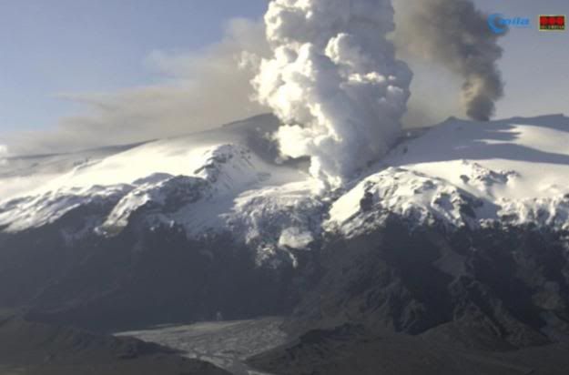
Ondertussen is het smeltwaterstroompje een smeltwatermeer geworden: http://eldgos.mila.is/eyjafjallajokull-fra-fimmvorduhalsi/
En nog een leuk berichtje:
quote:Many Volunteers Help Clean Ash in South Iceland
The cleaning begins. Around 100 people, including search and rescue team members, volunteered to help out with the ash cleaning last weekend. Photo by Benedikt Jóhannesson.
At least 100 people have volunteered to help clean ash from farms and other inhabited areas below the Eyjafjöll mountain range this weekend that were subject to the most extensive ash fall from the volcano in Eyjafjallajökull glacier.

be nice or go away
En hier een hele mooie fotoserie: http://gallery.me.com/thorleifur#100082&bgcolor=black&view=grid
be nice or go away
Status report van gisteren:
Sluiten lijkt me nog een beetje voorbarig Frutsel.quote:Eruption in Eyjafjallajökull - Status Report: 18:00 GMT, 29 April 2010
Icelandic Meteorological Office and Institute of Earth Sciences, University of Iceland
Compiled by: MJR / HB / MTG / SSJ / GS / BO
Based on: IMO seismic monitoring; IES-IMO GPS monitoring; IMO river gauges; web cameras of the eruption site from Vodafone, Mila, and Múlakot; IMO weather radar measurements; information from the local police; and aerial observations from a scientific flight with the Icelandic Coastguard (observation plane TF-SIF).
Eruption plume:
Height (a.s.l.): Not visible above clouds at 3.6–5.1 km (12–17,000 ft), but most likely below 3.6 km (12,000 ft). Before the overflight this morning, the eruption plume was not seen on radar images from Keflavík, nor on satellite images.
Heading: West and possibly southwest from the eruption site, but probably remaining close to Eyjafjallajökull due to light winds.
Colour: Cloud-cover obscured direct observations.
Tephra fallout: Light, fine-grained ash-fall reported in the morning during rain at
Ásólfsskáli, located 10.5 km south-west of the eruption site. Similar conditions also reported from a farm 12 km south-southwest of the eruption site at 15:00 GMT.
Lightning: Four lightning strikes detected over the summit of Eyjafjallajökull between 19:47 and 20:03 GMT on 28 April.
Noises: Booming sounds were reported yesterday evening, and again this morning, from Selsund, located ~40 km north-northwest of the eruption site.
Additional note: 16:13 GMT:Asulphur smell was detected at 3 km a.s.l. (10,000 ft) by pilots on a passenger flight 50–60 nautical miles east of Keflavík Airport.
Meltwater: Web-camera views show continued discharge of water from Gígjökull due to lava-ice interactions. On 28 April, the discharge of Markarfljót was measured twice at the old bridge, ~18 km downstream from Gígjökull. The flood that began at Gígjökull at ~11:30 GMT yesterday reached a peak discharge of 250 m3 s–1 two hours later at the bridge. Both yesterday and today, mean discharge from Gígjökull was 130–150 m3 s–1, which is higher than in previous days. The electrical conductivity of Krossá and Steinholtsá remains high (see report from 28 April for details).
Conditions at eruption site:
Airborne radar surveys from TF-SIF show a well-formed crater. Lava is spreading northward from the crater toward the head of Gígjökull. Ice continues to be melted by the propagating lava
front.
Seismic tremor: Intensity comparable to the preceding six days of eruptive activity.
Earthquakes: At 13:10 GMT, an Ml 1.5 earthquake was detected at shallow depth beneath the summit caldera; it is possible that this earthquake was a seismic explosion from the erupting crater.
GPS deformation: Horizontal displacement towards the centre of the volcano, in addition to vertical subsidence. These observations are consistent with deflation of a magma reservoir
beneath Eyjafjallajökull.
Magma flow: No measurements possible today.
Other remarks: No measurable geophysical changes within the Katla volcano.
Overall assessment: Plume elevations and magma discharge levels remain similar to the preceding six days of activity. Lava continues to flow north from the eruption site toward the head of the Gígjökull glacier. Today's explosive activity and ash production represents a fraction of conditions during the height of the eruption (14–17 April). Presently, there are no measurable indications that the eruption is about to end.
be nice or go away

Zeggen die drie aarbevingen op de Katla niets dan? 
http://en.vedur.is/earthquakes-and-volcanism/earthquakes/
http://en.vedur.is/earthquakes-and-volcanism/earthquakes/
Op zich niet veel, het is natuurlijk een actieve vulkaan (dwz met magmakamer e.d.) die hebben altijd wat activiteit, een beving kan domweg een uitstoot van wat overtollig gas oid zijn.quote:Op vrijdag 30 april 2010 15:17 schreef Mountainwatcher het volgende:
Zeggen die drie aarbevingen op de Katla niets dan?
http://en.vedur.is/earthquakes-and-volcanism/earthquakes/
Pas als er over een langere periode continu kleine oprispingen, bevingen en verschuivingen zijn icm een verandering in temperatuur en een ophoging van de grond door opbouw van magma gaat men denken aan bang worden voor een uitbarsting. En dan nog hoeft het geen grote te zijn, een uitbarsting is niet altijd enorm explosief compleet met pyroclastic flows en rondvliegende lavabommen, levensgevaarlijk gas en allesvernietigende aardschokken.
Nieuw dagraport van vanavond (altijd leuk nieuwe links. ) http://www2.norvol.hi.is/page/ies_Eyjafjallajokull_eruption
quote:Eruption in Eyjafjallajökull - Status Report: 17:00 GMT, 30 April 2010
Icelandic Meteorological Office and Institute of Earth Sciences, University of Iceland
Compiled by: MJR / MTG / FS / GS / SSJ
Based on: IMO seismic monitoring; IES-IMO GPS monitoring; IMO hydrological data; web cameras of the eruption site from Vodafone, Mila, and Múlakot; IMO weather radar measurements; information from scientists at Gígjökull; and aerial observations from the Icelandic Coastguard (observation plane TF-SIF).
Eruption plume:
Height (a.s.l.): Detected by weather radar at 15:20 GMT at an elevation of 2.8 km over the eruption site. TF-SIF observations at 15:40 GMT confirmed a steam plume rising to 4.5–5.1 km (15–17,000 ft). Clouds of ash at lower elevations observed drifting south of the eruption site.
Heading: South and south-west from the eruption site, but probably remaining close to Eyjafjallajökull due to light winds.
Colour: White (steam) clouds at higher elevation; dark grey (ash) clouds seen intermittently at lower elevation (see above).
Tephra fallout: Dark, fine-grained ash-fall reported over a 10 km region south of Eyjafjallajökull between Núpur and Skógar.
Lightning: No detections today over the eruption site (17:00 GMT).
Noises: Booming sounds reported in the vicinity of Eyjafjallajökull.
Additional note: Plumes of white plume were noticed over Gígjökull (15:40 GMT); this steam probably represents the position of the northward-flowing lava flow.
Meltwater: Web-camera views show continued discharge of water from Gígjökull due to lava-ice interactions. At 05:00 GMT a flood was detected leaving the Gígjökull lake basin. The flood reached a maximum discharge about two hours later at the old bridge over Markarfljót, ~18 km downstream. The flood was comparable in size to yesterday's gauged flows. At 14:00 GMT, meltwater flow beneath the bridge was ~200 m3 s–1. Discharge from Gígjökull decreased during the afternoon. Steaming blocks of rock are being deposited in the Gígjökull basin; these blocks are probably solidified lava from eruption. The electrical conductivity of Krossá and Steinholtsá remains high (see reports from 28 and 29 April for details).
Conditions at eruption site:
Airborne radar surveys from TF-SIF show a well-formed crater. Lava is spreading northward from the crater toward the head of Gígjökull. Ice continues to be melted by the propagating lava front.
Seismic tremor: Intensity comparable to the preceding six days of eruptive activity.
Earthquakes: No locatable seismicity detected beneath Eyjafjallajökull.
GPS deformation: Horizontal displacement towards the centre of the volcano, in addition to vertical subsidence. These observations are consistent with deflation of a magma reservoir beneath Eyjafjallajökull.
Magma flow: No measurements possible today.
Other remarks: No measurable geophysical changes within the Katla volcano.
Overall assessment: Plume elevations and magma discharge levels remain similar to the preceding seven days of activity. Lava continues to flow north from the eruption site and down the Gígjökull glacier. Today's explosive activity and ash production represents a fraction of conditions during the height of the eruption (14–17 April). Presently, there are no measurable indications that the eruption is about to end.
be nice or go away
Het lijkt wel of door de eruptie van EyFrutselNogwat de geologen op aarde wakker worden gemaakt..
quote:The eruption of Iceland’s Eyjafjallajökull set geologists on frantic runs to monitor possible volcano eruptions
Next on their radar is volcano Vesuvius located in the Bay of Naples, Italy.
Italian volcanologists are keeping track of two active sites after Guido Bertolaso, the president of Italy’s Civil Protection Department, announced that there is a possibility that the island of Ischia, a close neighbor of Vesuvius, will erupt very soon.
An estimated 650,000 people inhabit the slopes of Vesuvius and are at high risk. Due to the potentially detrimental effects of the island’s volcanos, the Italian minister called for a reevaluation of the emergency response team in the region around the two volcanoes. Up to 1 million people may need to be evacuated.
Katla, another volcano in Iceland is also under surveillance, according to recent speculations that Eyjafjallajökull might have upset Katla’s 92-year-long sleep.The reason for the prediction is historical evidence that the previous three times Eyjafjallajökull erupted, Katla followed.
“As bad as Eyjafjallajökull is, Katla could be much, much worse,” said Jay Miller, manager of Technical & Analytical Services at the A&M University in Texas, according to the Texas A&M University website.
Other volcanoes that are also getting special attention now include Mauna Loa, Hawaii; Sakurajima and Mount Hokodate-yama both in Japan; St. Helens, Washington; and Popocatepelt, Mexico.
Most of these volcanoes are among the most active in the world, so geologists have been watching them since their formation.
According to AFP, Bertolaso said, "Unfortunately, no one in the world can predict when a volcano will wake up … or predict an earthquake. There's a week or 10 days from the first signs until the moment it's too late
Lol @ deze zin:quote:Op vrijdag 30 april 2010 23:30 schreef Frutsel het volgende:
Het lijkt wel of door de eruptie van EyFrutselNogwat de geologen op aarde wakker worden gemaakt..
[..]
In het kader van op naar de volgende, next!quote:Next on their radar is volcano Vesuvius located in the Bay of Naples, Italy.
Wat me opvalt aan de dagrapporten is dat er steeds wordt gezegd dat er geen zicht is op het einde van de uitbarsting en dat er nog steeds veel water smelt. De doemdenkers van de klimaatlobby hadden het over het gevaar van verhoogde seismische activiteit als de gletsjers smelten omdat dit de druk op de aardkorst zou verminderen. Ik vraag me af of dat ook geldt voor IJsland. Het lijkt mij vergezocht.
be nice or go away
Op IJsland verwachten ze weer wat as:
De stoom/aswolken blijven voor het grootste gedeelte verstopt onder de wolken, ik vind het tijd voor opklaringen rondom IJsland.
@mountainwatcher: np.
[ Bericht 3% gewijzigd door kahaarin op 01-05-2010 16:10:47 ]
quote:Iceland volcano rumbles on, life does too
Posted on01 May 2010. Tags: Eyjafjallajokull, Iceland, Iceland volcano picture, volcano
The Iceland volcano erupting from Eyjafjallajokull is expected to cause ash fall in the southeast of Iceland today due to gentle north-westerly winds. Relatively small amounts of ash fell to the south of the volcano yesterday and Thursday, which temporarily stopped the farm clean-up operation.
Weather radar shows that the gas cloud reached around three kilometres high yesterday afternoon but the skies over the Eyjafjallajokull glacier began to clear again yesterday evening. Webcams pointing at the volcano showed clouds of steam coming from the rift on the Gigjokull glacial tongue, indicating that the lava running over the glacier is melting more ice under the brand new crust, RUV reports.
The ongoing eruption remains relatively stable and all Icelandic airports and main roads are open as usual, causing an increasing flow of visitors eager to see the volcano – although close-up viewing remains prohibited by police.
Photographer: Anders Peter Amsnæs / www.imagix.dk

De stoom/aswolken blijven voor het grootste gedeelte verstopt onder de wolken, ik vind het tijd voor opklaringen rondom IJsland.
@mountainwatcher: np.
[ Bericht 3% gewijzigd door kahaarin op 01-05-2010 16:10:47 ]
be nice or go away

Hmm, dat valt en staat met de Katla en of er een nieuwe krater opent onder de gletsjer, dan begint het feest namelijk van voor af aan. Het is nu stabiel, wel met nog immer verhoogde seismische rommels maar niet urgent paniek opwekkend. Zelfs de geleerden zijn het er over eens dat er nog niets anders van valt te zeggen als dat de uitbarsting stabiel is maar er nog geen zicht is op het einde van de uitbarsting of juist een nieuwe......quote:Op zaterdag 1 mei 2010 16:04 schreef Re het volgende:
ik moet over 2 weken weer 3x vliegen...
verkapte tvp dus
be nice or go away
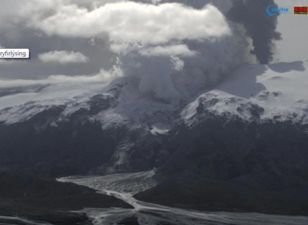
Zo, opgeklaard, steamy as ever. (pun intended. )
http://eldgos.mila.is/eyjafjallajokull-fra-thorolfsfelli/
http://eldgos.mila.is/eyjafjallajokull-fra-thorolfsfelli/
be nice or go away


Het is nu helder, en het is zeker geen dooie boel.
http://eldgos.mila.is/eyjafjallajokull-fra-fimmvorduhalsi/
http://eldgos.mila.is/eyjafjallajokull-fra-fimmvorduhalsi/
Ziet er mooi uit 
Dare to unleash my rage..
That's my secret Captain... I'm always angry...
There's nothing like a trail of blood, to find your way back home.
That's my secret Captain... I'm always angry...
There's nothing like a trail of blood, to find your way back home.
Jammer dat we niet kunnen inzoomen
Dare to unleash my rage..
That's my secret Captain... I'm always angry...
There's nothing like a trail of blood, to find your way back home.
That's my secret Captain... I'm always angry...
There's nothing like a trail of blood, to find your way back home.
Dagrapport van gisteren:
Er is nog wel een beetje asuitstoot bij de orginele krateruitgang en de uitbarsting is op een vergelijkbaar niveau als de afgelopen dagen.
Het betreft dus geen 2e krater maar een goot die door de lava in de gletsjer is uitgesmolten, daarom is de 2e pluim zo wit, het is alleen maar stoom.quote:Eruption in Eyjafjallajökull - Status Report: 18:00 GMT, 1 May 2010
Icelandic Meteorological Office and Institute of Earth Sciences, University of Iceland
Compiled by: MJR / HB / FS / SSJ / BO
Based on: IMO seismic monitoring; IES-IMO GPS monitoring; IMO hydrological data; web cameras of the eruption site from Vodafone, Mila, and Múlakot; IMO weather radar measurements; information from scientists at Gígjökull; aerial observations from two scientific overflights: TF-SIF (10:30–11:00 GMT) and Eagle Air (16:40–17:15 GMT).
Eruption plume:
Height (a.s.l.): TF-SIF observations at 10:30 GMT confirmed an ash plume rising to 4–5.4 km (13–18,000 ft) near to Eyjafjallajökull. Clouds of ash at lower elevations observed drifting south-east of the eruption site. No verifiable detections from the weather radar at Keflavík Airport.
Heading: South-east from the eruption site. Plume track detected up to 400 km from the eruption site on AHRR and MODIS satellite imagery (12:11 GMT and 13:30 GMT).
Colour: Dark grey (ash) clouds observed up to 4 km a..s.l. (~13,000 ft). White (steam) plumes rising from Gígjökull, north of the eruption site.
Tephra fallout: Dark, coarser-grained ash-fall reported at Ytri Sólheimar (11:00 GMT), located 22 km south-east of Eyjafjallajökull.
Lightning: No detections today over the eruption site (18:00 GMT).
Noises: Booming sounds reported in the vicinity of Eyjafjallajökull.
Additional note: Plumes of white steam extend partway down Gígjökull. The uppermost plume represents the position of the northward-flowing lava flow, whereas the lower plumes are from hot meltwater.
Meltwater:
Discharge remains high from Gígjökull due to lava-ice interactions. Aerial observations of Gígjökull show that warm meltwater has carved a trench partway down the glacier. The electrical conductivity of Krossá and Steinholtsá remains high (see reports from 28–30 April for details).
Conditions at eruption site:
A 200-m-wide eruptive crater is visible within the ice cauldron. The rim of the crater appears to be ~30 m lower than the adjacent ice surface. Lava has propagated ~1 km north from the crater toward Gígjökull. Although steam is forming over the lava front, no large emissions of steam originate from the eruptive crater.
Seismic tremor:
Intensity comparable to the preceding eight days of eruptive activity.
Earthquakes:
No locatable seismicity detected beneath Eyjafjallajökull.
GPS deformation:
Horizontal displacement towards the centre of the volcano, in addition to vertical subsidence. These observations are consistent with deflation of a magma reservoir beneath Eyjafjallajökull.
Magma flow:
No measurements possible today.
Other remarks:
No measurable geophysical changes within the Katla volcano.
Overall assessment:
Plume elevations and magma discharge levels remain similar to the preceding eight days of activity. Lava continues to flow north from the eruption site and down the Gígjökull glacier. Today's explosive activity and ash production represents a fraction of conditions during the height of the eruption (14–17 April). Presently, there are no measurable indications that the eruption is about to end.
Er is nog wel een beetje asuitstoot bij de orginele krateruitgang en de uitbarsting is op een vergelijkbaar niveau als de afgelopen dagen.
be nice or go away

Was me paar dagen geleden al opgevallen dat er veel meer rook uit de buurt van de gletsjertong kwam, benieuwd of we straks ook lava gaan zien als de goot de rivier bereikt. Vanacht was het ook weer een mooi schouwspel.quote:Op zondag 2 mei 2010 12:06 schreef kahaarin het volgende:
Dagrapport van gisteren:
[..]
Het betreft dus geen 2e krater maar een goot die door de lava in de gletsjer is uitgesmolten, daarom is de 2e pluim zo wit, het is alleen maar stoom.
Er is nog wel een beetje asuitstoot bij de orginele krateruitgang en de uitbarsting is op een vergelijkbaar niveau als de afgelopen dagen.
Als deze stijging in de grafieken ziet... ik kan het helaas niet interpreteren. Wat denken jullie?
http://hraun.vedur.is/ja/Katla2009/gosplott.html
[ Bericht 0% gewijzigd door Mountainwatcher op 02-05-2010 22:19:16 ]
http://hraun.vedur.is/ja/Katla2009/gosplott.html
[ Bericht 0% gewijzigd door Mountainwatcher op 02-05-2010 22:19:16 ]
Ik denk dat het niks betekent!quote:Op zondag 2 mei 2010 21:48 schreef Mountainwatcher het volgende:
Als deze stijging in de grafieken ziet... ik kan het helaas niet interpreteren. Wat denken jullie?
http://hraun.vedur.is/ja/Katla2009/gosplott.html
Kijk eens naar de grote zwarte letters bovenaan de pagina die er sinds kort staan
Ik zag ze ook pas net
Opgeblazen gevoel of winderigheid? Zo opgelost met Rennie!
Nee, voor de Katla, maar voor de moeilijke naam ;-) Het ziet er nogal stijgend uit, sommige pieken zitten al hoger dan tijdens het begin van de eruptie
Hmm, misschien zo eens ff kijken.quote:Op zondag 2 mei 2010 17:19 schreef mouzzer het volgende:
[..]
Was me paar dagen geleden al opgevallen dat er veel meer rook uit de buurt van de gletsjertong kwam, benieuwd of we straks ook lava gaan zien als de goot de rivier bereikt. Vanacht was het ook weer een mooi schouwspel.
Over de grafieken, bedenk dat een verandering van windrichting al voor trillingen kan zorgen, ik denk dat het smeltwater is en ijs dat zich aan het zetten is, het dagrapport rept ook over lawaai van brekend ijs dus denk ik dat het niet in de berg zit maar dat het ligt aan het ijs dat er bovenop ligt.
be nice or go away
Eyjafjallajökull?quote:Op zondag 2 mei 2010 22:41 schreef Mountainwatcher het volgende:
Nee, voor de Katla, maar voor de moeilijke naam ;-) Het ziet er nogal stijgend uit, sommige pieken zitten al hoger dan tijdens het begin van de eruptie
be nice or go away
Dan zou ik nu even kijkenquote:Op zondag 2 mei 2010 23:03 schreef kahaarin het volgende:
[..]
Hmm, misschien zo eens ff kijken.
Over de grafieken, bedenk dat een verandering van windrichting al voor trillingen kan zorgen, ik denk dat het smeltwater is en ijs dat zich aan het zetten is, het dagrapport rept ook over lawaai van brekend ijs dus denk ik dat het niet in de berg zit maar dat het ligt aan het ijs dat er bovenop ligt.
http://eldgos.mila.is/eyjafjallajokull-fra-fimmvorduhalsi/