WKN Weer, Klimaat en Natuurrampen
Lees alles over het onstuimige weer op onze planeet, volg orkanen en tornado's, zie hoe vulkanen uitbarsten en hoe Moeder Aarde beeft bij een aardbeving. Alles over de verwoestende kracht van onze planeet en tal van andere natuurverschijnselen.


quote:Dodental Vietnam loopt op naar veertig
Het dodental van de tropische storm Mirinae in Centraal-Vietnam is gestegen tot minstens veertig. Er zijn ook elf vermisten. In verschillende steden traden rivieren buiten hun oevers. Straten staan meer dan een meter onder water. Alleen al in de Vietnamese provincie Phu Yen vielen volgens een krant dertien doden. De nationale autoriteiten gaven nog geen cijfers over de gewonden vrij.
De storm gaat gepaard met windvlagen met een snelheid tot 133 km per uur en hevige stortregens. Maandagochtend kwam Mirinae aan land in de provincies Phu Yen, Binh Dinh, Quang Ngai en Khanh Hoa. Meer dan 150 huizen zijn vernield. Het dak van verschillende scholen en ziekenhuizen is weggewaaid. Minstens 900 hectare rijstvelden en 830 hectare akkers zijn vernield of staan onder water.
Vietnam Airlines heeft maandag 34 vluchten van en naar de centrale regio van Vietnam geannuleerd waardoor 2.000 passagiers in de problemen kwamen. Meer dan 27.000 mensen zijn geëvacueerd. De overheid waarschuwt de 104.000 vissers in 18.000 visbootjes om bescherming te zoeken.
Toen Mirinae vorig weekend over de Filipijnen raasde, was ze nog een taifoen en stierven er negentien mensen. Volgens de autoriteiten valt de dodentol in Vietnam relatief mee omdat de mensen op hun hoede zijn sinds de taifoen Ketsana, die in september 172 levens eiste in Vietnam

Wat te fuck 
Doe mee met het voorspellen van het weer!
Weekvoorspelling | Week 12 (invullen tot 16-03 - 11:59)
Maandvoorspelling Maart (Inzendingen gesloten)
Jaarvoorspelling 2025 / 2026
Weekvoorspelling | Week 12 (invullen tot 16-03 - 11:59)
Maandvoorspelling Maart (Inzendingen gesloten)
Jaarvoorspelling 2025 / 2026

quote:Late tropische storm Ida bedreigt Nicaragua
Voor de Caraïbische kust van Midden-Amerika heeft zich een wervelstorm ontwikkeld. Volgens het Amerikaans orkaancentrum in Miami bedreigt de tropische storm 'Ida' vooral Nicaragua. Hij zal donderdagmorgen lokale tijd mogelijk op orkaansterkte het vasteland in Nicaragua treffen en dan verder richting Honduras trekken.
Overstromingen
De regering in Managua heeft uit voorzorg een stormwaarschuwing gegeven en liet noodverblijven voor duizenden mensen in de regio voorbereiden. Er wordt vooral rekening gehouden met overstromingen en grondverschuivingen, waardoor in de regentijd de meeste mensen om het leven komen.
Rustig orkaanseizoen
Het orkaanseizoen, dat officieel tot eind oktober duurt, is dit jaar in de hele regio betrekkelijk goed verlopen. In de Caraïben, waar het voorbije jaar verschillende stormen vooral in Cuba en Haïti zware verwoestingen hebben aangericht, heeft dit jaar geen enkele orkaan het vasteland getroffen.

Toe maar, ben wel eens benieuwd wat die gaat doen boven de golf
Je weet maar nooit, voor je het weet kan het net zo erg als Katrina worden als alles wil mee werken
Je weet maar nooit, voor je het weet kan het net zo erg als Katrina worden als alles wil mee werken
Doe mee met het voorspellen van het weer!
Weekvoorspelling | Week 12 (invullen tot 16-03 - 11:59)
Maandvoorspelling Maart (Inzendingen gesloten)
Jaarvoorspelling 2025 / 2026
Weekvoorspelling | Week 12 (invullen tot 16-03 - 11:59)
Maandvoorspelling Maart (Inzendingen gesloten)
Jaarvoorspelling 2025 / 2026
Dat denk ik niet want het water is er al behoorlijk kouder gewordenquote:Op donderdag 5 november 2009 21:22 schreef SpeedyGJ het volgende:
Toe maar, ben wel eens benieuwd wat die gaat doen boven de golf
Je weet maar nooit, voor je het weet kan het net zo erg als Katrina worden als alles wil mee werken
Ah dat heb ik nog niet gezien this indd kouder geworden maar een TS of cat 1 zou toch haalbaar moeten zijn 
Doe mee met het voorspellen van het weer!
Weekvoorspelling | Week 12 (invullen tot 16-03 - 11:59)
Maandvoorspelling Maart (Inzendingen gesloten)
Jaarvoorspelling 2025 / 2026
Weekvoorspelling | Week 12 (invullen tot 16-03 - 11:59)
Maandvoorspelling Maart (Inzendingen gesloten)
Jaarvoorspelling 2025 / 2026

Orkaan treft 40.000 mensen in Nicaragua
Orkaan Ida heeft in Nicaragua 40.000 personen getroffen. Er is grote materiële schade en minstens één vermiste. De orkaan heeft huizen, waterputten en grote delen van de oogst vernield.
De schade en het aantal slachtoffers kan nog oplopen door de hevige regens die volgen achter de orkaan. Verschillende dorpen zijn afgesneden van stromend water, elektriciteit en communicatieverbindingen.
De orkaan trof de kusten van Nicaragua gisteren met rukwinden tot 140 kilometer per uur. Ze heeft minstens 530 huizen, 240 waterputten en 1.900 hectaren landbouwgrond vernield. (afp/gb)
hln
IDA is nu weer in open water terecht gekomen en is op weg naar de golf.
quote:TD Ida emerging into Caribbean again
Tropical Depression Ida has begun to emerge in the western Caribbean and will soon gain strength back to a Tropical Storm.
As of 4 PM EST, Ida was located on the northeast Honduran border edging back into the western Caribbean with top winds of 35 mph.
The current movement is N at 8 mph.
The system is expected to slowly move northward toward the Yucatan Channel and then into the Gulf of Mexico over the next few days as it strengthens back to a moderate to strong Tropical Storm.
Residents along the Yucatan need to monitor Ida closely for strong gusty winds and heavy rain. Then mariners and residents of the northeast Gulf of Mexico will need to monitor the progress of Ida as it heads slowly northward.
Ida will combine with a strong High Pressure area to the north to bring a srong pressure gradient that will result in gusty winds all across eastern Florida down into the Keys and Gulf of Mexico.
High Surf and Dangerous Rip Currents will persist for days and boaters and swimmers are urged to use extreme caution. If you are not a good swimmer you don't want to press your luck and take on the waves you could lose your life.
Stay tuned all weekend to The Weather Channel with frequent updates on Tropical Storm Ida with Tropical Expert Dr Steve Lyons and Weather.Com.
On average, about one tropical storm develops every two years during the month of November and every three years a hurricane develops. The southwest Caribbean is the most favored location for this to occur.
The last season with a named storm in November was 2008 when Paloma developed and impacted the Cayman Islands and Cuba.
IDA gaat weer een orkaan worden. Trekt nu tussen Mexico en Cuba door naar de Golf van Mexico.
Het water is daar nog rond de 26/27 graden.
Het water is daar nog rond de 26/27 graden.


Tja ik zei het al een beetje, oke extreem wordt het misschien niet maar toch.
Doe mee met het voorspellen van het weer!
Weekvoorspelling | Week 12 (invullen tot 16-03 - 11:59)
Maandvoorspelling Maart (Inzendingen gesloten)
Jaarvoorspelling 2025 / 2026
Weekvoorspelling | Week 12 (invullen tot 16-03 - 11:59)
Maandvoorspelling Maart (Inzendingen gesloten)
Jaarvoorspelling 2025 / 2026

Orkaan Ida eist levens in El Salvador
CANCUN - Orkaan Ida heeft dit weekeinde ten minste 42 levens geëist in El Salvador. Dit aantal loopt vermoedelijk nog op, aldus het ministerie van Binnenlandse Zaken van het Centraal-Amerikaanse land.
De meeste slachtoffers vielen door modderstromen. Deze werden veroorzaakt door de hevige regenval die de orkaan met zich meevoerde.
Ida doet later op zondag de Golf van Mexico aan. Inwoners van Mexicaanse kustgebieden worden uit voorzorg geëvacueerd. Buitenlandse toeristen in populaire badplaatsen als Cancun en Playa del Carmen worden nog niet geëvacueerd.
Ida valt vooralsnog in de eerste en laagste categorie op de zogeheten Saffir-Simpsonschaal met windkrachtsnelheden tot 152 kilometer per uur. (ANP)
AD
Tropische storm Mirinae eiste al 122 levens in Vietnam
Tot nu toe zijn er in het centrum van Vietnam al minstens 122 doden gevallen bij de doortocht van de tropische storm Mirinae. Dat melden de Vietnamese autoriteiten. Ze schatten de materiële schade op ruim 5.000 miljard dong (ongeveer 190 miljoen euro). Twee mensen zijn vermist en 145 raakten gewond, zo blijkt uit een nieuw rapport van het nationale comité voor overstromingen en stormen
Grondverschuiving
Bij een grondverschuiving in een provincie ten noorden van het gebied dat door Mirinae getroffen werd, vielen nog eens minstens dertien doden in de nacht van donderdag op vrijdag. Volgens de nationale statistieken leidde Mirinae tot het instorten, de beschadiging of de overstroming van ruim 100.000 woningen. Honderdduizenden hectare bebouwde akkers raakten eveneens verwoest bij de doortocht van de storm.
Voedsel
De prioriteit van de overheden bestaat uit "het bevoorraden met water en voedsel van de getroffen bevolking en de problemen rond milieuvervuiling oplossen", luidt het. Mirinae maakte eerder ten minste 27 slachtoffers op de Filipijnen. (belga/kh)
hln
[ Bericht 1% gewijzigd door #ANONIEM op 08-11-2009 21:16:20 ]
Zo gaat wel lekker zeg dit jaar daar zo.
Doe mee met het voorspellen van het weer!
Weekvoorspelling | Week 12 (invullen tot 16-03 - 11:59)
Maandvoorspelling Maart (Inzendingen gesloten)
Jaarvoorspelling 2025 / 2026
Weekvoorspelling | Week 12 (invullen tot 16-03 - 11:59)
Maandvoorspelling Maart (Inzendingen gesloten)
Jaarvoorspelling 2025 / 2026


Anja is cat.4 inmiddels... je ziet ze niet vaak naar het zuiden gaan en afbuigen richting de Westkust van Australie
't is wel een schattig klein dingetje.
Maar dat zegt niets.
TC Tracy was klein, maar heeft indertijd een behoorlijke bende gemaakt in australië
Maar dat zegt niets.
TC Tracy was klein, maar heeft indertijd een behoorlijke bende gemaakt in australië
Ik ben een eckte rapnegert
quote:2009 A YEAR OF "IT ONLY TOOK ONE"
For much of the hurricane season, nothing really caused much alarm except for perhaps hurricane Bill which did impact the U.S. East Coast and the Canadian Maritimes. No hurricanes made landfall in the U.S. this season but it all came down to one storm that made all the difference: Ida. The late season hurricane brought floods and loss of life to portions of Central America before making landfall as a tropical storm along the central Gulf Coast. From there, it transitioned in to a powerful extra-tropical storm that lashed the Mid-Atlantic states for several days. In the end, Ida will be remembered as THE storm of 2009. Do not be surprised if it ends up as a $1 billion event, perhaps more. Miles and miles of beach were eroded away and in some areas, homes and businesses fell in to the sea. In Rodanthe, NC, the highway was all but washed away and will take some time to repair. The power of one storm and its legacy in how we remember the 2009 hurricane season is proof once again that it does not take an over-active season to cause big trouble. At least we are done, there will be no more hurricanes this season which officially ends on the 30th. However, the threat of Nor'easters, which Ida was compared to and perhaps technically was, will remain throughout the upcoming winter season. From Long Island to Cape Hatteras, the shore line remains very vulnerable and any subsequent storms will only add to the problems.
IDA dus nog behoorlijke schade aangericht lees ikquote:ANOTHER COASTAL STORM SHOWING UP IN THE MODELS, NOT GOOD FOR BATTERED EAST COAST BEACHES
Though not tropical in nature, it looks like another coastal storm is in store for portions of the East Coast over the weekend and early next week. A shot of energy coming in from a powerful Pacific storm will develop a low pressure area at the surface in the northern Gulf of Mexico, bringing more rain to the Deep South and Southeast. It looks like it will then take a similar track the Ida did and move off the Mid-Atlantic coast late this weekend. While not as powerful a storm as the Nor'easter that Ida became, any storm is going to be a problem for the beaches ravaged by numerous coastal non-tropical storms this season. Be aware of the situation and if you have property along the coast from North Carolina to Long Island, you might want to keep an extra close eye on this situation. We are in for a rough winter as the type of pattern we are in will favor the development of these Nor'easter events and when the cold air gets involved, look out, major snow storms are likely. For now, people who just dealt with the Ghost of Ida just might be dealing with yet another significant erosion event with the coming storm. I will post more about it over the coming days as the computer models resolve its track and intensity better.
Even wennen, dat ze op het zuidelijk halfrond de andere kant opdraaien.
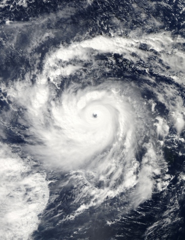
Tropical Cyclone Anja
After forming as a tropical storm over the Southern Indian Ocean on November 14, 2009, Anja strengthened to a cyclone one day later. By November 16, 2009, Anja was a Category 3 cyclone, with maximum sustained winds of 105 knots (195 kilometers per hour), and gusts up to 130 knots (240 kilometers per hour). Anja was located near 14.7 degrees South and 68.3 degrees East.
The Moderate Resolution Imaging Spectroradiometer (MODIS) on NASA’s Terra satellite captured this true-color image on November 16, 2009. Far away from any major landmasses, Anja sprawls over the Southern Indian Ocean, her long arms spiraling outward, and her eye easily detectable.
Tropical Cyclone Anja

After forming as a tropical storm over the Southern Indian Ocean on November 14, 2009, Anja strengthened to a cyclone one day later. By November 16, 2009, Anja was a Category 3 cyclone, with maximum sustained winds of 105 knots (195 kilometers per hour), and gusts up to 130 knots (240 kilometers per hour). Anja was located near 14.7 degrees South and 68.3 degrees East.
The Moderate Resolution Imaging Spectroradiometer (MODIS) on NASA’s Terra satellite captured this true-color image on November 16, 2009. Far away from any major landmasses, Anja sprawls over the Southern Indian Ocean, her long arms spiraling outward, and her eye easily detectable.
Tropical Cyclone 26
In het midden van de Pacific
Tropical Cyclone 2
Zuid Oost Afrika en Madagaskar dus..
In het midden van de Pacific
Tropical Cyclone 2
Zuid Oost Afrika en Madagaskar dus..
Gaat lekker mag onze kant wel even opkomen
Doe mee met het voorspellen van het weer!
Weekvoorspelling | Week 12 (invullen tot 16-03 - 11:59)
Maandvoorspelling Maart (Inzendingen gesloten)
Jaarvoorspelling 2025 / 2026
Weekvoorspelling | Week 12 (invullen tot 16-03 - 11:59)
Maandvoorspelling Maart (Inzendingen gesloten)
Jaarvoorspelling 2025 / 2026

(Super)typhoon Nida
Op dit moment raast er door de Pacific Nida, een supertyphoon (cat 5) met windsnelheden van zo'n 216 km/h en windstoten tot 233 km/h. Nida scheert langs eilandjes als Guam en San Jose in de Grote Oceaan maar een echte landfall zit er nog niet in, het dichtst bij zijn de Filipijnen op 1400 km afstand. Haar richting lijkt naar Japan of Taiwan te gaan, maar het is onduidelijk in welke toestand Nida dan zal zijn, aangezien Nida naar kouder water gaat.
onweer-online
Weer of geen weer, altijd actueel www.onweer-online.nl
doe maar nietquote:Op dinsdag 24 november 2009 14:14 schreef SpeedyGJ het volgende:
Gaat lekker
| Wordfeud: marcel-o |plug.dj/uptempo |<-- draai zelf je platen

quote:Nida was strengthening to a super typhoon near Guam when the Moderate Resolution Imaging Spectroradiometer (MODIS) on NASA’s Aqua satellite captured this true-color image on November 25, 2009. MODIS acquired this image 1:55 p.m. local time (03:55 UTC). In the six-hour time span during which this picture was taken, Nida strengthened from a category 3 typhoon to a category 4 super typhoon. On November 25, Unisys Weather reported that Nida had maximum sustained winds of 150 knots (280 kilometers per hour) with gusts up to 180 knots (335 kilometers per hour).
leuk stukje informatie

rest van het artikelquote:Living on an island in the balmy tropics of the western Pacific, the residents of the Philippines are accustomed to tropical storms. The storms can form at any time of the year, and they frequently impact the island nation as they track west across the Pacific. This image illustrates how much rain the Philippines received from tropical cyclones between May and October in 2009. In that period, 12 named storms poured heavy rain over the Philippines. Two storms, Ketsana and Parma, brought unusually heavy flood-inducing rain within a two-week span at the end of September and early October. The two storms alone left at least 460 people dead.
Inorbit: zeg dat dan typluie triangeljosti
Beauregard: Een beetje FOK!ker laat het brood door z'n moeder smeren.
Ecosia
ek's 'n flash drive, jy's 'n floppy
Beauregard: Een beetje FOK!ker laat het brood door z'n moeder smeren.
Ecosia
ek's 'n flash drive, jy's 'n floppy
Komt die naar ons toe?  kommah kommah
Doe mee met het voorspellen van het weer!
Weekvoorspelling | Week 12 (invullen tot 16-03 - 11:59)
Maandvoorspelling Maart (Inzendingen gesloten)
Jaarvoorspelling 2025 / 2026
Weekvoorspelling | Week 12 (invullen tot 16-03 - 11:59)
Maandvoorspelling Maart (Inzendingen gesloten)
Jaarvoorspelling 2025 / 2026
Cleo vormt (nog) geen bedreiging. Het is nu een cat. 3 met een windveld van 185 km/uur en windstoten tot 230 km/uur.

quote:Forecasts 2010
An early forecast for 2010 calls for an “above-average” hurricane season, according to the Tropical Meteorology Project at Colorado State University.
The team expects 11 to 16 named storms, 6 to 8 hurricanes and 3 to 5 major hurricanes — ones with sustained winds of 111 mph or greater.
Today’s prediction marks the first time William Gray’s team at CSU has provided a range of storms in its December early season forecast. The report is the team’s 27th year of hurricane seasonal predictions.
Because the report is based on Atlantic basin conditions, the team says its forecast could change substantially by the start of the hurricane season, which runs on June 1 to Nov. 30.
Gray’s team plans to list specific numerical forecasts in its next forecast on April 7.
“The Atlantic basin has the largest year-to-year variability of any of the global tropical cyclone basins,” Phil Klotzbach, the team’s leader, said in a release.
A weakening El Nino will allow more hurricanes to form, the team predicts. El Nino is a pattern of warmer-than-usual water in the Pacific Ocean, near the equator. The pattern creates more wind shear over the Atlantic, which breaks up tropical storms as they form.
“We anticipate the current El Nino event to dissipate by the 2010 hurricane season,” Gray said in the release, “and warm sea surface temperatures are likely to continue being present in the tropical and North Atlantic during 2010 — conditions that contribute to an above-average season.”
Their forecast is based on a statistical prediction scheme that uses 58 years of “hindcast” data. Over that time period, the scheme correctly forecasted above- or below-average seasons in 44 out of 58 years, the team said.
For the 2010 Atlantic basin hurricane season, the CSU hurricane forecast team expects:
*A 64 percent chance that at least one major hurricane will make landfall on the U.S. coastline in 2010. The long-term average probability is 52 percent.
*40 percent chance (the long-term average is 31 percent) of a major hurricane making landfall along the U.S. East Coast, including the Florida Peninsula.
*A 40 percent chance (the long-term average is 30 percent) of a major hurricane making landfall along the Gulf Coast, from the Florida Panhandle west to Brownsville.


Zo dan, dat gaat nog lekker zeg
Doe mee met het voorspellen van het weer!
Weekvoorspelling | Week 12 (invullen tot 16-03 - 11:59)
Maandvoorspelling Maart (Inzendingen gesloten)
Jaarvoorspelling 2025 / 2026
Weekvoorspelling | Week 12 (invullen tot 16-03 - 11:59)
Maandvoorspelling Maart (Inzendingen gesloten)
Jaarvoorspelling 2025 / 2026
speedyquote:
Dat is je pier linkquote:WARNING: ProxyAV has detected a virus/PUS in this
file!
File has been dropped.
2009-12-14 09:15:52+01:00CET
ProxyAV (Version 3.2.3.1(39265)) - http://www.BlueCoat.com/
Antivirus Vendor: Kaspersky Labs
Scan Engine Version: 8.0.1.23
Pattern File Version: 091214.055900.3364740 (Timestamp: 2009.12.14 05:59:00)
Virus/PUS: "Trojan.JS.Agent.awm" found!
www.weerstation-holwerd.nl
[ Bericht 6% gewijzigd door Jumparound op 16-12-2009 09:06:26 ]
Inorbit: zeg dat dan typluie triangeljosti
Beauregard: Een beetje FOK!ker laat het brood door z'n moeder smeren.
Ecosia
ek's 'n flash drive, jy's 'n floppy
Beauregard: Een beetje FOK!ker laat het brood door z'n moeder smeren.
Ecosia
ek's 'n flash drive, jy's 'n floppy


quote:Tropische cycloon Laurence stormt af op West-Australië
De tropische cycloon Laurence zet met een snelheid van 230 kilometer per uur koers naar de kust van Kimberly in West-Australië. Het is de eerste cycloon van het seizoen die de Australische deelstaat bedreigd. Bewoners van de kust hebben de raad gekregen om zich voor te bereiden op de cycloon.
De tropische storm bevindt zich momenteel op 55 kilometer ten noorden van Kuri Bay en 155 kilometer ten noordoosten van Cockatoo Island. Verwacht wordt dat ze vandaag het eiland en de Koolaneilanden bereikt met windstoten van honderd kilometer per uur. De hevige wind zal volgens de laatste voorspellingen ook gepaard gaan met stevige buien.
De bewoners van de eilanden hebben de raad gekregen om zich voor te bereiden op de storm. De plaatselijke luchthaven wordt alvast gesloten en de aboriginalgemeenschap in Oombulgurri sluit ook haar deuren. Laurence onstond zondag boven de Timorzee en is in kracht toegenomen van categorie één naar categorie vier.
quote:Vier doden door cycloon Mick op de Fiji's
Zware onweders hebben op de Fiji Eilanden in de Zuidzee enorme schade aangericht. Minstens vier mensen zijn om het leven gekomen, toen cycloon Mick gisteren met topsnelheden van 150 kilometer per uur over de eilanden raasde. Dat deelden de media vanuit de hoofdstad Suva mee. Meer dan 2000 mensen vluchtten weg uit hun beschadigde huizen.
Mick was de eerste zware wervelstorm van het zomerseizoen op het zuidelijk halfrond. De stroomvoorziening was op vele plaatsen onderbroken en vele wegen overstroomden en waren niet meer toegankelijk. Op het eiland Yasawa werd een toeristisch complex aan het strand zwaar beschadigd. De ongeveer 60 gasten moesten vluchten naar een speciaal voor onweders gebouwd noodverblijf.
Niemand raakte gewond, zei een woordvoerster op de Nieuw-Zeelandse radio. De meeste toeristen op Fiji komen uit Australië en Nieuw-Zeeland. (afp/adb)
hln